Haiti Earthquake Maps
A massive 7.0 magnitude earthquake has struck Haiti. Whilst the extent of the damage and cost of the quake is still unclear there are fears thousands of people may have died.

Before and after satellite imagery of an area of Port-au-Prince
Ushahidi Haiti Earthquake Map

Ushahidi, in a joint effort with UN OCHA/Colombia and the International Network of Crisis Mappers (CM*Net) have produced this Google Maps mashup to track the latest news and incidents related to the Haiti earthquake.
The map reports incidents such as collapsed roads and buildings to try and provide as much up-to-date news for Haitian citizens as possible. It is possible to submit information to the map by completing a short form.
Via: Street View Gallery
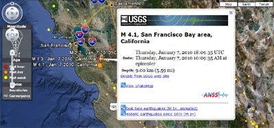
Microformats USGS Earthquake Map

This Google Map mashup displays data from the United States Geological Survey. Currently the map shows a lot of activity in Haiti.
Haiti Earthquake Tweet Map
Mibazaar has quickly put together this Twitter map that shows real-time Tweets about the Haiti earthquake. He has also created a YouTube Video Map showing geotagged videos of news reports on the earthquake.
Earthquakes in the Last Week
This map shows recent earthquakes around the world. It also includes the latest earthquake news. The map uses different coloured map markers to show the strength of different earthquakes.
Real-time USGS Earthquake Mapplet
This mapplet plots the past week of earthquakes around the world, showing the location, time and magnitude. Each earthquake includes a link to the USGS earthquake website for more information.
USGS Real-Time Earthquakes
This map uses the Google Earth browser plug-in with the USGS's KML of the past 7 days' earthquakes.
This Google Earth browser plug-in tool also works with other KML's. Just replace the KML address in your browser address bar to view other KML's in the plug-in.
USGC Did You Feel It Map?

Although the USGC doesn't seem to be mapping their Twitter data yet they do have a Did You Feel It Map? The map uses Google Maps to show user contributed reports of earthquakes. Just click on the 'Report Unknown Event' button if you have felt an earthquake that is not yet mapped.
________________
Before and after satellite imagery of an area of Port-au-Prince
- American Red Cross International Response Fund
- Pan American Relief appeal for Haiti
- British Red Cross Haiti Appeal
- Oxfam Haiti Appeal
Ushahidi Haiti Earthquake Map
Ushahidi, in a joint effort with UN OCHA/Colombia and the International Network of Crisis Mappers (CM*Net) have produced this Google Maps mashup to track the latest news and incidents related to the Haiti earthquake.
The map reports incidents such as collapsed roads and buildings to try and provide as much up-to-date news for Haitian citizens as possible. It is possible to submit information to the map by completing a short form.
Via: Street View Gallery
Microformats USGS Earthquake Map
This Google Map mashup displays data from the United States Geological Survey. Currently the map shows a lot of activity in Haiti.
Haiti Earthquake Tweet Map
Mibazaar has quickly put together this Twitter map that shows real-time Tweets about the Haiti earthquake. He has also created a YouTube Video Map showing geotagged videos of news reports on the earthquake.
Earthquakes in the Last Week
This map shows recent earthquakes around the world. It also includes the latest earthquake news. The map uses different coloured map markers to show the strength of different earthquakes.
Real-time USGS Earthquake Mapplet
This mapplet plots the past week of earthquakes around the world, showing the location, time and magnitude. Each earthquake includes a link to the USGS earthquake website for more information.
USGS Real-Time Earthquakes
This map uses the Google Earth browser plug-in with the USGS's KML of the past 7 days' earthquakes.
This Google Earth browser plug-in tool also works with other KML's. Just replace the KML address in your browser address bar to view other KML's in the plug-in.
USGC Did You Feel It Map?
Although the USGC doesn't seem to be mapping their Twitter data yet they do have a Did You Feel It Map? The map uses Google Maps to show user contributed reports of earthquakes. Just click on the 'Report Unknown Event' button if you have felt an earthquake that is not yet mapped.
________________


Comments
http://realtimetools.de
using the google maps apifor flash