
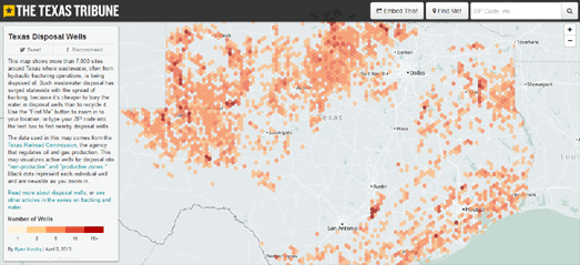
The Texas Tribune has published a map showing the location of disposal wells where waste-water, often from hydraulic fracturing sites, is being disposed of in the state. Texas Disposal Wells visualizes the location of 7,000 disposal wells in Texas.
The map uses hexagonal binning to highlight the number of wells within an area.. You can zoom in on the map to view the location of the individual wells.
The Texas Tribune uses the Mapbox platform. Mapbox has written a nice tutorial on how to use hexagonal binning with Mapbox created maps. Binning: an Alternative to Pointmaps explains how the free and open source QuantumGIS tool can be used to create a hexagon density layer, which you can then overlay on top of a Mapbox map.
No comments:
Post a Comment