
The Accidental Skyline is a well designed map of New York showing the Floor Area Ratio of building lots. The map is designed to highlight where new development could occur across the city.
A quirk of New York City planning regulations allows for the transfer of unused development rights from one site to another development site. The transfer of these air rights allows buildings to become taller and bigger than the city zoning code otherwise allows.
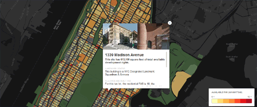
Using the map you can select individual building lots on the map to view the available building rights and check to see if the lot has been combined with other lots. Lots with development rights are shaded yellow to red. You can also select to view historic districts on the map (a factor which may also influence what can be built on a site).
No comments:
Post a Comment