
The availability of accurate maps is particularly important in times of emergency to help disaster response teams and aid agencies to effectively manage the teams on the ground.
Humanitarian Open Street Map Team (HOT) is a non-profit organization which coordinates the creation and distribution of free mapping resources to support humanitarian relief. Since the devastating earthquake in Nepal HOT has been organizing the response of the Open Street Community to improve the OSM maps of Nepal.
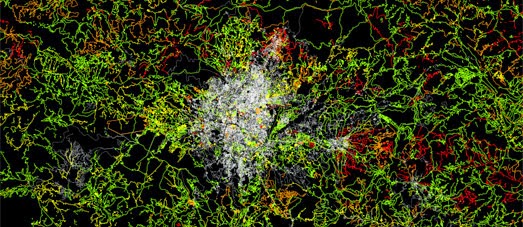
Mapbox has created a map visualizing the improvements to OpenStreetMaps in Nepal following the 2015 earthquake. Nepal Freshness shows the OpenStreetMap roads and features which have been created or updated since the earthquake. The yellow features are the newest updates to the map.
The response of OpenStreetMap contributors has been truly amazing. Over 2,000 different volunteers have been helping improving the map of Nepal, quadrupling the road coverage and adding 30% more buildings to OpenStreetMap in Nepal.
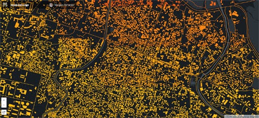
Mapbox has also released a map which is designed to help OSM mappers identify areas of Nepal which are likely to have suffered the most damage. The Nepal Damage Analysis map visualizes approximate impact levels for every building and road in OpenStreetMap.
Building footprints on the map are colored by the interpolated peak ground acceleration at each location. The red buildings are the ones which are likely to have experienced the strongest shocks. The areas with the reddest buildings are the places which have experienced the most ground movement and are therefore likely to have suffered the most damage.
No comments:
Post a Comment