
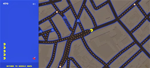
Indubitably the mapping event of the week was Google Maps' annual April Fools prank. This year Google Maps transmogrified into a global PacMan game - and not just for April 1st.
April Fools Day may be over but if you go to Google Maps you can still play the game. Click the PacMan button that appears at the bottom of the map and Google Maps turns into a fully functioning PacMan game. If you don't see the button then zoom in on an area with lots of roads.
Make sure to turn on sound if you want to wacca, wacca, wacca across the map in style.

As fun as Google Maps PacMan may be my favorite map was this clever 'about' page from Japan Registry Services.
When the map first loads you are presented with an interactive photograph which I presume was created with the Image Map Types function within the Google Maps API. You can explore the image overlay using the Google Maps usual panning and zooming controls. You can also use the numbered menu to quickly navigate to different sections of the image map.
More surprises await you when you zoom out on the map. One zoom level even appears to have a video embedded within the map tile layers (I have no idea how this effect was achieved). After the video finishes playing you can mouse-over the numbers on the map and the people in the map magically move and interact with the numbers.
When you zoom right out the map changes to Google Maps satellite view and shows you the offices of Japan Registry Services in Tokyo.

PacMan wasn't the only map game this week. We were also blessed with this difficult transit map quiz.
Can you recognize a city purely from its transit network? Well you can now find out on this fun Google Maps based quiz, Guess the City by Transit Stops.
The game is very simple. You are shown a series of maps which only contain a city's transit stops. You are then given a choice of four cities to pick from. Guess the right city and you get a point. There are five cities in each level and four levels in all. However be warned the quiz gets more difficult as you level-up.

I was also impressed this week with another attractive map style created using Mapbox Studio. Blueprinted is a map style designed to resemble cyanotype reproductions of technical drawings. Cyanotype is a photographic printing process, which was at one time particular popular with engineers, that produces a cyan-blue print - commonly known as blueprints.
This attractive Blueprinted map style was created by Lauren Ancona using Mapbox Studio. If you like the style you can fork the repository for the Mapbox Studio files on Github.
No comments:
Post a Comment