

The Ocean Cleanup claims that "80% of river plastic pollution entering the world's oceans stem from 1000 rivers". In Plastic Sources the organization has mapped out the world's 1,000 most polluting rivers and the 30,000 rivers responsible for the other 20% of the plastic entering our oceans.
Currently the map includes very little information on how the organization calculates the amount of plastic waste distributed by each river or how they determine which are the most polluted rivers. The organization says that their model is based on data on 'plastic waste, land-use, wind, precipitation and rivers' but not where that data comes from. It does say that "Detailed information on our modeling approach and data will follow in our scientific update."
On the interactive map the 1,000 worst plastic polluting rivers are marked with large red & white circular markers. The other 3,000 polluting rivers around the world are marked with smaller blue markers. If you select a river's marker on the map you can read more about how much plastic the river is estimated to be carrying into the ocean.
The Ocean Cleanup has developed technology which they claim can intercept plastic in rivers and therefore stop it reaching the ocean. Having identified the 1,000 most polluting rivers it now wants to use its technology in those rivers and by so doing reduce by 80% the amount of plastic entering the oceans.

Around 8 million tonnes of plastic is dumped into the world's oceans every single year. This plastic is not only dangerous to marine life it is also a danger to us as well. Once the plastic enters the food chain it ends up being a threat to the health of people around the world. The plastic in the world's oceans comes from mismanaged plastic waste and waste which is intentionally dumped into the world's rivers, which then flows into our seas. Studies are now beginning to map where this plastic ends up and where it originates from.
Litterbase is one organization attempting to collate the results of scientific studies researching the levels of plastic pollution found in the world's oceans. Currently Litterbase provides a summarized overview of the results from over 1,900 studies into the amount and composition of litter and its effect on marine environments. An example of one of these summaries is Distribution of Litter Types in Different Realms, which is an interactive map created from the results of 916 scientific publications on the amount, distribution and composition of litter in the world's oceans.
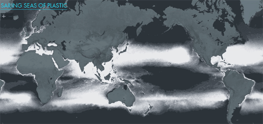
There are gaps in our knowledge where little scientific research has taken place, for example around Africa and the Polar regions. One way that we can fill in these gaps in our knowledge is by modeling the density of pollution in the oceans based on the results of scientific studies. Sailing Seas of Plastic is a dot density map which shows the estimated concentration of floating plastic in the oceans based on the results of 24 survey expeditions (2007-2013) and on wind and ocean drift models.
Each dot on the Sailing Seas of Plastic map represents 20 kg of floating plastic. According to the map there are 5,250 billion pieces of plastic adrift on the seas of the world. If you want you can also overlay the sailing tracks of the 24 survey expeditions on top of the dot map.
1 comment:
If you watch Boyan Slat's presentation on the unveiling of the Interceptor, he states at about 03:18 that they have installed camera's on the bridges of the most polluting rivers to monitor the amount of plastic coming out of them (https://www.youtube.com/watch?v=KyZArQMFhQ4). He doesn't state how many rivers these are installed on but certainly gives more information than on the website.
Post a Comment