
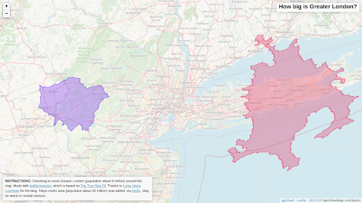
Alasdair Rae has used the leaflet-truesize plug-in for the Leaflet mapping platform to create a map which allows you to compare the size of Greater London and the Tokyo metro area with any other location in the world.
Alasdair's How big is Greater London map contains two draggable polygons. One polygon represents the size of Greater London (placed over London) the other is the size of the Tokyo metro area (placed over Tokyo). You can simply click and grab either of these polygons to drag it around the map and compare its size with any other global location.
The leaflet-truesize plug-in is a great tool for quickly creating a map visualization showing the geographical size of something. You can also use the Google Maps API's draggable polygons to create simple comparison maps.
Comparison maps such as:
How much of America does Bill Gates own?
How Big is Glastonbury?
How Big is the Great Pacific Garbage Patch?
How Big is Occupied Ukraine?
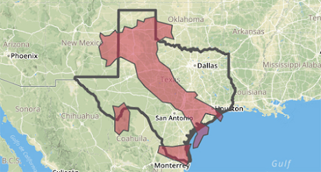
The Reprojector tool allows you to upload any GeoJSON polygon onto an interactive map. This GeoJSON can be anything you want, including country or state borders. Once you have uploaded a polygon onto the Reprojector map you can move the shape around to overlay the polygon on any location in the world. When you are happy with the location of your polygon you can then download a GeoJSON file with the data to display your polygon in its new position.
You can see in the screenshot above an example where I positioned a GeoJSON polygon of Italy on top of the state of Texas. If you want to experiment with moving different country polygons around on the Reprojector map then you might find GeoJSON Maps of the Globe useful. This simple tool allows you to click on a country on an interactive map and then download it as a GeoJSON file (which you can then upload onto the Reprojector map).
No comments:
Post a Comment