Great New Polygons in the Maps API v3
Google have added Polylines and Polygons to Maps API v3 and made some great improvements to their use. Polylines and polygons allow you to draw lines or filled regions on a map, specify stroke and fill styles, and handle events.
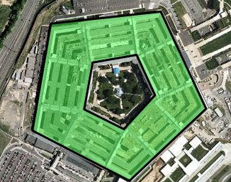
Now you can create polygons with holes like in this Pentagon example.
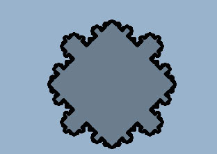
You can also now create vertices with polygons as in this fractal snowflake poly example.
Via: Google Geo Developers Blog
_____________
Now you can create polygons with holes like in this Pentagon example.
You can also now create vertices with polygons as in this fractal snowflake poly example.
Via: Google Geo Developers Blog
_____________


Comments
Alternatively you could add labels using the Label library -
http://googlemapsmania.blogspot.co.uk/2011/05/introducing-google-maps-label-library.html