Measure Distances with Google Maps
Build a Distance Finder with the Google Maps API

This tutorial will teach you how to build a distance finder using the Google Maps API v3. If you want to see what the finished map will look like there is a demo here.
The application allows the user to enter two addresses. The addresses are then shown on a Google Map with the straight line distance between the two addresses calculated and the approximate driving time shown as well.
Distance Finder
Calculate the straight-line distance between two points.
Distance Measurement Tool
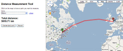
Google Maps Labs has a new distance measurement tool. If you select the tool from Google Maps a small ruler will be added to the bottom of the map next to the distance scale.
________________
This tutorial will teach you how to build a distance finder using the Google Maps API v3. If you want to see what the finished map will look like there is a demo here.
The application allows the user to enter two addresses. The addresses are then shown on a Google Map with the straight line distance between the two addresses calculated and the approximate driving time shown as well.
Distance Finder
Calculate the straight-line distance between two points.
Distance Measurement Tool
Google Maps Labs has a new distance measurement tool. If you select the tool from Google Maps a small ruler will be added to the bottom of the map next to the distance scale.
________________


Comments