Thursday, May 14, 2009

Angels & Demons on Google Maps

Path of Illumination

To celebrate the Japanese release of Angels and Demons, the movie directed by Ron Howard and starring Tom Hanks, YouTube have released a Google Maps competition. The objective of the competition is to find four sculptures at "Path of Illumination" in Marunouchi using Google Maps and Google Maps Street View. Prizes include an Alfa Romeo 159 and a $1000 travel coupon.

Unfortunately the competition is only open to Japanese residents. However that doesn't mean that non-Japanese residents can't play the game and try to find the four earth, wind, air and fire sculptures hidden on the Google Map (you just won't win any prizes).

________________

US Cities Going Green with Google Maps

Baltimore Green Map

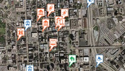
Baltimore Green Map has used the map making tool, Green Map, to map Baltimore's ecological and cultural resources. Over 250 green sites in the Baltimore region are featured on the map and it is possible to nominate other sites to be included on the map.

The map shows a number of positive citizen activities in Baltimore, such as community gardens planted, murals painted, parks’ partnerships activated, “green” schools, farmers markets, bicycle-friendly roadways; recycling centers and healthy eating venues.

Easton Urban Ecology Maps

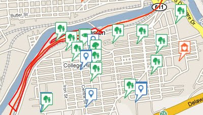
Easton in Pennsylvania has created two green Google Maps mashups, an Urban Gardens and Urban Ecology Map and a Public Transportation and Biking Map.

The Urban Gardens and Urban Ecology Map displays community gardens, church gardens, select private gardens and other public gardens. Also included on this map are sites of interests in Easton such as restaurants, community centers, museums, and other attractions.

The Public Transportation and Biking Map identifies bike trails, pedestrian urban walking trails, greenways, parks, scenic views and by-ways, waterways, transportation facilities, and environmental amenities in Easton.


All three maps featured in this post use Green Map Icons V3 for the map markers. The Baltimore Green Map website has a legend page that identifies what each icon represents.

________________

Wednesday, May 13, 2009

African Tourism on Google Maps

African Tourism Portal

The African Tourism Portal is an interactive African tourist guide which features rich media content including videos, photographs and tourism podcasts. The site currently covers countries in the southern half of the continent.

The African Tourism Portal allows the user to select categories of map marker to view for each country in the guide. It is possible to select categories of map marker from 'attractions', 'restaurants' and 'accommodation'. Within each of these categories it is then possible to select from a number of subcategories.

Clicking on any of the star shaped 'destination' map markers opens an information window which contains rich media content about that location. The rich media content includes podcast descriptions of the destination's attractions and/or tourist guide videos and photographs of the location from Flickr.

This video provides a good introduction to The African Tourism Portal:


Via: Programmable Web

________________

Plug & Play Google Maps

Plug and Play Maps

Plug and Play Maps is a free map creation tool that can create a Google Map from spreadsheets or similar tabulated data, from KML files, from GIS shapefiles or from data in a web database. To create a map using Plug and Play you don't need to know HTML, Javascript or the Google Maps API because Plug and Play does all the mapping work for you.

It is possible to define a number of parameters with Plug and Play to define the design of your map. You can set the map size, define the initial map type, configure the map controls and set the intitial map view. It is also possible to style the data and the map legend.

Plug and Play Maps have a demo gallery of the types of maps that are able to be created using the service.

Other Google Map Creation Sites
Via: Mapperz

________________

Tour the World in Street View

STREETvi

This new Google Maps mashup lets users view the Google Maps Street View for locations around the world. For each location it is also possible to view Wikipedia articles, YouTube videos and Panoramio photographs alongside the Street View and Google Map.

Registered users of the site can also save and share their favourite places, add comments about a location and create their own tours. STREETvi also uses Google Translate so that users can view the site in their preferred language.

________________

Tuesday, May 12, 2009

Sky Map for Android

Google Sky Map
Google have today released a new application for Android phones called Google Sky Map. The application allows you to discover and browse the night sky just by pointing your phone to space.

The application is able to determine your current location and show you a star map for your location.

This video explains the application in more detail:


Also See

Via: Google LatLong

________________

Google Map of Eurovision Song Contest

Eurovision Song Contest 2009
The Eurovision Song Contest Semi-Finals are just about to be broadcast live on television stations across Europe. If that wasn't enough punishment Soren Johannessen has released a Google Gadget version of his Google Maps mashup that geotags the YouTube videos for each country's entry to the contest.

The gadget is embedded below:


Via: Microformats.dk

________________

Google Earth Plug-in & Twitter

Earthtwit

Earthtwit is a very cool mashup of the Google Earth plugin and Twitter. The mashup allows you to browse Google Earth and post an update to Twitter with a link to any location in Google Earth. When your followers on Twitter click on the short URL of the view you submitted they will then be taken to the view in the Google Earth plugin.

This is a great way to share your favourite locations or favourite 3D buildings in Google Earth.

Here's the Eiffel Tower in Earthtwit: http://bit.ly/xf0BL

Maptwit
The same developer, Hussein Nasser, has also created a Google Maps version of Earthtwit. Maptwit allows you to send a Twitter update with a short URL link and message from any location. When your followers on Twitter click on the link they will be taken to the location on Google Maps within Maptwit.

Geshout

If that wasn't enough Hussein Nasser has also created a new social network with the Google Earth plugin. The application allows you to connect and chat to your friends from within the Google Earth plugin.

Users' profile photos are shown on the Google Earth plugin. It is therefore possible to view the locations of your friends directly in Google Earth. It is also possible to see the geographical connections between different users, friend connections are shown by lines between various users.

As with Earthtwit and Maptwit it is also possible to send an update with a link to a location to your Twitter account.

________________

Ask Questions About Anywhere

Travellr

Do you want to know where you can find the best pizza in New York of where you can buy the best fish and chips in London? Perhaps you want to know the cheapest way to get from Venice to Vienna or the best place to stay to watch the Tour De France. If so Travellr can help you find the answer.

Travellr is a new website that lets anyone ask questions about anywhere in the world and receive answers from locals or past visitors. In this way Travellr hopes to ensure that you can find the best local knowledge about anywhere in the world.

Travellr also includes an intelligent recommendation system. Travellr can recommend questions to you based on where you've lived and travelled and the more you participate in the conversation, the more Travellr will tailor your recommendations to your own interests.

The site uses Google Maps in a number of ways. There is a Google Map of recent questions in all locations. This map geotags all the recent questions asked on the site. Using the map it is possible to zoom in on a location and browse the questions asked about the area.

Travellr also includes a list of popular destinations. Choosing one of these destinations takes you to a dedicated page which includes a Google Map of the location.

Now, where were the best fish & chips in London?

________________

Google Maps Discovers America

DiscoverAmerica.com

DiscoverAmerica.com is the official travel and tourism website of the United States. The U.S. Travel Association has worked together with all 50 state tourism offices and more than 100 convention and visitors bureaus to create this one-stop travel planning source, featuring special deals and offers to help U.S. residents save time and money and get on the road this summer.

DiscoverAmerica.com contains over 7,000 pages featuring official content on all 50 states, the five U.S. territories, more than 100 cities and regional destinations, and more than 3,000 popular trip activities. Each location on the site features a Google Map and a list of Attractions & Activities, Hotels, Dining Options, Shopping Venues, Travel Articles and Itineraries.

Each Google Map includes an option to get the driving directions to the chosen location from anywhere else in the United States.

________________