Showing posts with label Africa. Show all posts

Wednesday, August 04, 2021

516 Million Building Outlines in Africa

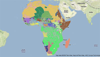
Google’s Open Buildings is a new open dataset containing the location and geometry of 516 million buildings across Africa.The data includes the polygon outline of each building, its size in square meters and a confidence score of it being a valid building.

Anyone can download the full dataset of over 500,000,000 buildings or download smaller datasets for individual level 4 S2 cells. The full data can be downloaded in CSV format or the tile geometry and URLs in GeoJSON format. 

 It is hoped that the data will help refine an understanding of where people live, helping authorities to identify where infrastructure and vital services are required. It is also hoped that the data will contribute to a better understanding of population density, help authorities plan emergency responses, help with the rollout of digital address systems, and help with national planning.

The buildings were detected from satellite imagery by AI. The building data in some areas may be more accurate than in others. These confidence differences can emerge for a number of reasons. For example geological or vegetation features may have been confused with built structures. In some areas the delineations between individual buildings may not be clear in the satellite imagery. Buildings which are the same colors as the surrounding environment or terrain may be difficult to identify. Also very small buildings may be difficult to determine at the satellite resolution.

Wednesday, February 25, 2015

Mapping African Democracy


President Teodoro Obiang Nguema Mbasogo of Equatorial Guinea and President Jose Eduardo dos Santos of Angola have both been leaders of their respective countries for 35 years. According to the Economist neither country qualifies as a full democracy. There are 27 countries in Africa ruled by an authoritarian regime or a nominal democracy. The Economist claims that Mauritius is the only African country to qualify as a full democracy.

In a series of interactive maps The Guardian has mapped various indicators of democracy and government in Africa. Using data from the Economist Intelligence Unit Democracy Index 2014, the CIA Factbook, the World Intellectual Property Organisation and Intellectual Ideal the newspaper has mapped out the presidential term limits, voter turnouts and the longest serving leaders in African countries.

Power in Africa: Democracy Mapped uses CartoDB to present a series of interactive maps showing the state of democracy, the number of registered voters and the number of voters in African countries. It also includes maps of presidential terms limits and the lengths served by Africa's current leaders.

Monday, August 05, 2013

On Safari with Google Maps


Wild Africa Live is a Google Map that shows animal sightings reported by users of the Wild Africa app over the last 24 hours. The animals are displayed on the map with categorised map markers which display the species of animal sighted. Users can click on the individual markers to discover when an animal was spotted.

Wild Africa Live has also created a Google Map of all the sightings submitted over the last eight months. The Historic Sightings map shows the location of over 14,000 sightings made by owners of the Wild Africa Live app.

Friday, September 14, 2012

African Elephant Populations on Google Maps


The Save the Elephants charity has created the Elephants in Peril website with the help of a Google Earth Outreach Development Grant.

The website includes two Google Maps to show the location of where elephants are being illegally killed in Africa and the current African elephant population density. The maps were created with the help of Fusion Tables and Google Maps Engine.

By creating and maintaining these two maps Elephants in Peril hope to bring together public data sets and to reveal the complete story of elephant populations over time and understand what trends can be seen.

Via: Google Lat Long

Wednesday, March 07, 2012

African Conflicts on Google Maps


The Map of Conflict in Africa is a Fusion Tables driven Google Map of all African conflicts between 1997 and 2010.

The article accompanying the map includes a link to the Google Fusion Table holding the data so it is possible to access the table and create a heat map of the conflicts. The developer, Zachary M. Jones, also says he is working on "producing a map that will sequentially display data points (a subset of the ones shown here) by conflict and over time."

It would also be great if conflicts post 2010 were added, obviously the map at the moment doesn't include conflicts arising out of the Arab Spring.

Thursday, February 18, 2010

Maps Domains in 30 African Countries

Google have today launched Google Maps domains in 30 African countries. Unfortunately the Google Maps for Africa blog hasn't announced which 30 African countries have been given their own domains.

Mapperz, however, has done a good job in tracking down 12 of the new domains:

http://maps.google.com.na/ Nambia
http://maps.google.com.ng/ Nigeria
http://maps.google.com.et/ Ethiopia
http://maps.google.com.sl/ Sierra Leone
http://maps.google.cg/ Congo, Republic of,
http://maps.google.ci/ Côte d'Ivoire
http://maps.google.dj/ Djibouti
http://maps.google.ga/ Gabon
http://maps.google.gm/ The Gambia
http://maps.google.com.gh/ Ghana
http://maps.google.mw/ Malawi
http://maps.google.sn/ Senegal


Via: Official Google Africa Blog

_____________

Thursday, October 29, 2009

Southern Africa Tourism on Google Maps

Southern Destinations

Southern Destinations have produced a number of Google Maps to highlight some of the stunning tourism opportunities available in southern Africa. The site includes a number of Google Maps for South Africa, Botswana, Namibia, Mozambique and Zambia.

Each of the destinations includes a number of categories to choose from when exploring the area. For example, the Cape Town map includes golf courses, activities, wine regions, adventure activities and whale watching opportunities. Each category includes a number of map markers that, when clicked, open information windows that display photographs and videos of the chosen location.

________________

Tuesday, October 27, 2009

Google Maps Safari - Part Two

Africa Photo Safari

Soren Johannessen was inspired by my animated map of explorer/ecologist J. Michael Fay's close-up imagery of Africa and decided to create a Google Earth browser plug-in tour using the same imagery.

The tour features music by Idealist and also comes with a link to the kmz file, so it is also possible to watch the tour directly in Google Earth.

_____________

Saturday, October 24, 2009

Google Maps Safari

Safari

One of the hidden treasures of Google Maps is Mike Fay's Megaflyover images of Africa. These images provide some super close-ups of a number of African animals. This Safari map animates through a few of the best images from the Megaflyover.

Unfortunately this map tries to default back to Google Maps' normal zoom levels. The secret in using this map is to press the 'Play again' button (bottom right) which forces the map to zoom in beyond the default levels and exposes some great close up shots of the animals.

_____________

Monday, September 14, 2009

Global Finances on Google Maps

Standard Bank Google Map

Standard Bank is a leading African banking group that focuses on emerging markets. The bank is using Google Maps to highlight the organisation's operations and publicise it's deals around the world.

The map's markers are colour coded by 'operations, 'deals', 'accolades' and 'news'. The category of map marker currently shown on the map can be further refined by using the drop down menus at the top of the map. Featured deals are also shown in the map sidebar. Clicking on any of the sidebar links will centre the map on that featured deal and open an information window with further information.

_____________

Thursday, August 13, 2009

Map of Essential Medicine Shortages

Stop Stock-Outs


A stock-out is when a pharmacy has no medicine on the shelves. Obviously a stock-out can have very grave consequences for patients. Stop Stock-Outs aim to ensure access to essential medicines for who ever is in need of them. To help achieve this aim the organisation have held a 'pill check week'.

During 'pill check week', researchers visited public health institutions in Kenya, Malawi, Uganda and Zambia and checked on the availability of a list of 10 essential medicines. These are medicines that should be readily available in public health facilities.

The team then reported the results through short messaging services (SMS) to a common site, and then added the data to a Google Map. The resulting map provides a snap shot of the shortage of essential medicines in these countries just in this one week.

_____________

Monday, July 20, 2009

African Safari Camps on Google Maps

Expert Africa

Tour operator Expert Africa have a large number of Google Maps mashups for the countries, areas, safari camps and lodges in Africa that they send their customers to. Here are a couple of examples:


The maps allow customers to view close up satellite images of the camps and lodges and view details of nearby towns. The map markers for each of the camps and lodges include pictures and a brief description of the camp. Each marker also contains a link to a detailed description of the camp or lodge.

Expert Africa have just added a new feature to the maps allowing anyone to add any of the maps to their own website.

________________

Friday, July 10, 2009

Special Site for Obama's Ghana Visit

Obama Visits Africa

Google have teamed up with the Ministry of Tourism in Ghana to create a special site for President Obama's visit to the country. The site features a Google Earth plug-in tour of President Obama's itinerary in Ghana and a Google Map that includes embedded YouTube videos of two of the President's destinations on his visit.

The website includes a link to a specially created YouTube channel, that contains videos of some of Ghana's tourist sights, and a Picassa slideshow showing photographs of the country.

Via: Official Google Africa Blog

_____________

Wednesday, June 24, 2009

Africa's First Live Traffic Google Map

eNowNow Live Lagos Traffic

Nigerian website eNowNow has launched what I think is the first African Google Maps mashup to show live traffic conditions. The map shows 'live' traffic updates for Lagos. Currently the traffic conditions are updated between the hours of 6am and 8pm Monday to Friday, however the frequency of updates may vary.

eNowNow have overcome the lack of any central or government information about traffic conditions with a marvellously low-tech solution. Traffic information is collected via a team of mobile traffic monitors, who each follow a series of pre-determined routes around Lagos. At a number of pre-selected points along these routes the monitors stop and take a photograph of the current traffic conditions which is then sent via an MMS message.

Roads on the map are coloured to show the current speed of traffic. If you click on any of the map markers an information window opens with information about the speed of traffic and a recently taken photo.

_____________

Wednesday, May 13, 2009

African Tourism on Google Maps

African Tourism Portal

The African Tourism Portal is an interactive African tourist guide which features rich media content including videos, photographs and tourism podcasts. The site currently covers countries in the southern half of the continent.

The African Tourism Portal allows the user to select categories of map marker to view for each country in the guide. It is possible to select categories of map marker from 'attractions', 'restaurants' and 'accommodation'. Within each of these categories it is then possible to select from a number of subcategories.

Clicking on any of the star shaped 'destination' map markers opens an information window which contains rich media content about that location. The rich media content includes podcast descriptions of the destination's attractions and/or tourist guide videos and photographs of the location from Flickr.

This video provides a good introduction to The African Tourism Portal:


Via: Programmable Web

________________

Wednesday, February 25, 2009

Harvard Map of Africa

AfricaMap

This Google Map mashup contains an amazing amount of data about the African continent. AfricaMap has been developed by the Center for Geographic Analysis at Harvard University to make spatial data on Africa easier for researchers to discover and explore.

The incredible amount of data on this map is organised into three main categories: View, Map Layers and Places. The three categories can be accessed via tabs at the top of the map.

The View tab is the one to select to view the map and to select from the different map types. The Map Layers tab is the main tab for selecting what data you wish to see presented on the map. The data is then sub-categorised into Base Mapping, Economic, Environmental, Ethno Linguistic, Ethno Classification, Harvard Collections, Historic Maps 1800 to 1950, Historic Maps 1800 to 1950, Local Projects, Period Maps, Place Names & Political and Population.

The Places tab allows users to access Place Name information across the continent by category. The database contains hundreds of Place Types for Africa (i.e. administrative divisions, populated places, farms, streams, etc.).

________________