The Digital Atlas Ortelius
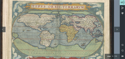
The Atlas Ortelius was the first 'modern' world atlas. Abraham Ortelius printed his 'Theatrum orbis terrarum' at the end of the sixteenth century in Antwerp. Before the publication of Ortelius' atlas maps were printed and sold separately or composite atlases could be made to order. These composite atlases usually consisted of maps of different sizes and styles.
Ortelius' 'Theatrum orbis terrarum' was a collection of maps, all of the same size and all with the same look & feel, sold as one book. This book was also not custom made for one client but was published in several copies for sale to many different customers. First published in 1571 the 'Theatrum orbis terrarum' consisted of 53 individual maps. The atlas was an instant success and the first edition quickly sold out. New editions were soon published and German, French, Spanish, English and Italian editions also soon appeared.
You can now explore Ortelius' atlas for yourself on the Royal Library of the Netherland's Digital Masterpiece: Theatrum orbis terrarum. This digitized copy of the Atlas Ortelius allows you to view all pages of the atlas and pan and zoom around each of the atlas' 53 individual maps. The library's digitized version of the atlas also includes a guided tour of the 'Theatrum orbis terrarum'. This guided tour provides information about some of the more interesting maps in the atlas and about the contemporary knowledge & understanding of the world from which the maps were drawn.
The Atlas Ortelius which has been digitized here is the library's own copy. This copy of the atlas includes the 53 maps from the first Dutch edition from 1571. The copy also includes later additions and must have been bound some time after 1584.


Comments