A Bird's Eye View of America
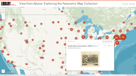
The Library of Congress owns a huge collection of panoramic bird's eye maps of American cities, most of which were published in the late nineteenth and early twentieth centuries. You can now browse and explore these vintage panoramic maps of American cities on the library's View from Above interactive map.
The map allows you to view over 1,500 panoramic maps of towns and cities across the United States. The location of the library's panoramic maps are shown using a clustered marker system. Simply click on a marker to view a listing of maps in that area. Selecting an individual map's marker will reveal a preview image of the map and links to see the fully digitized map on the Library of Congress website. You can also search for locations using the map's search bar.
Leaflet-IIIF is a simple to use plug-in for creating a Leaflet based browser for IIIF manifests or images shared using the IIIF Image API. Using this plug-in you can make interactive maps from tens of thousands of manuscripts, paintings and other images held by some of the best known global art galleries, museums and universities. And the Library of Congress.
I used the Leaflet-IIIF plug-in to create a Leaflet.js map of one of the vintage panoramic maps from the Library of Congress. This Sherbrooke Panoramic Map shows an 1881 panoramic map of a southern Quebec city. I've even added some markers to identify some of the city's notable buildings on the map.

When visiting cities the photographers of the Detroit Publishing Co would often find a high building from which to take a series of bird's eye view photographs. When stitched together these pictures can be made into one long panoramic image of the city. Which is what I did to create this interactive Leaflet panorama of Indianapolis in 1907.
Comments