Showing posts with label TVMaps. Show all posts

Thursday, July 31, 2025

Play Destination X

Have you ever dreamed of playing GeoGuessr in real life? Well, hold on to your hats, because the new reality show Destination X (airing in the US and the UK) is an interactive geoguessing game that you can actually play yourself - right from your own home.

In Destination X, contestants are whisked away on a bus with blacked-out windows, dropped at secret locations across Europe, and challenged to solve cryptic clues to figure out exactly where they are. It’s part travel adventure, part mystery, and part geography challenge - and here’s the best bit: you can join in online.

The Destination X Game lets you play along in real time. You’ll tackle geography quiz questions, and with every correct answer, your guessing area on an interactive map shrinks by 100 kilometers. Then, you’ll get a GeoGuessr-style photo clue of a famous European landmark. Identify it, and your search zone narrows again.

A new Destination X Game is released for each episode, challenging you to identify that episode’s location. If you play while an episode airs, you can even earn a special “LIVE” badge by finding the location before the contestants do.

To play Destination X, you’ll need to sign in to the BBC’s iPlayer - so you must be a UK TV licence payer to play.

I think it also helps to watch the show while playing. I tried the game without having seen the episode, and although I answered every quiz question correctly and identified the landmark, my guessing circle still covered half of Europe. Without the extra context from the show itself, it was virtually impossible to pinpoint last night's location. Presumably if I had watched the show I would have had many more clues to help me in my quest.

Monday, March 31, 2025

Free TV & Radio Maps

tvgarden is an interactive map that brings the world of live television to your fingertips. Inspired by the long running success of Radio Garden (which allows users to explore global radio stations through an interactive 3D map,) tvgarden applies the same concept to television, offering a seamless and engaging way to watch live TV from around the world.

Features and User Experience

One of TVGarden’s standout features is its intuitive 3D globe interface, which enables users to select channels by clicking on different countries. This makes for an effortless way to discover international news, entertainment, sports, and cultural programming. If you’re feeling adventurous, the “Random Channel” button lets you explore new content with just one click, making every visit to tvgarden a fresh experience.

The map sidebar provides an alternative method of discovering live TV. Here stations are organized into categories, including News, Music, Sports, Movies, Documentaries, and more, allowing users to quickly find content that matches their interests.

tvgarden curates a wide selection of live TV channels sourced from the IPTV community and YouTube. This ensures a broad variety of programming that is constantly updated. 

tvgarden admits to having been inspired by the popular Radio Garden interactive map. Since 2016, Radio Garden has helped users discover and listen to music from around the world. From the rhythmic Pacific sounds of Radio Guam to the distant Siberian melodies of Radio Sabir, Radio Garden’s interactive 3D map lets users explore and listen live to thousands of radio stations worldwide."

Radio Garden features radio broadcasts from hundreds of different countries. Just click on a marker on this interactive map, and you can tune in to local radio stations that provide live internet radio streams. Radio Garden is a great way to explore the sounds of different cultures worldwide. It even includes a "Balloon Ride" feature that transports users to random radio stations. Some users have likened the "Balloon Ride" feature to a blend of Radio Garden and GeoGuessr, as you can try to guess the location of each random radio station while the map slowly pans out to reveal where you are in the world.

Monday, January 29, 2024

The Interactive Anime Atlas

The Anime Site Mapping Project is a mapping project dedicated to plotting the real-world locations that are featured in popular anime series. It's like a giant treasure hunt for anime fans, but except instead of discovering gold, you can uncover the real-world cafes, shrines, and scenic vistas that inspired your favorite anime shows.

Currently the Anime Site Mapping Project consists of four main interactive maps. Three of the maps are dedicated to individual anime shows: Heya Camp, Kimi no Na wa and Yuru Camp. The fourth, main map allows you to explore the real-world locations of all three of the featured anime shows on one map. 

The Kawai Miyagawa Bus Stop, as feattured in Kimi no Na wa

The real fun for me though is hidden in the individual episode breakdowns for each anime series. On these episode pages individual locations featured in each episode of a show are listed with links to Open Street Map and Google Maps. Follow the Google Maps link and you can then compare an actual still of the anime depiction of the location with the real location on Google Maps Street View.

Via: Weekly OSM

Tuesday, October 11, 2022

New Maps of Westeros & Middle-earth

Amazon Prime's The Rings of Power is an epic tale which involves multiple charachters and plot-lines. So far we have been introduced to hobbits, dwarves, elves and humans. All of whom seem to be involved in their own individual journeys through Middle-earth. The show itself often uses maps to help illustrate these epic journeys being undertaken by the show's major characters. 

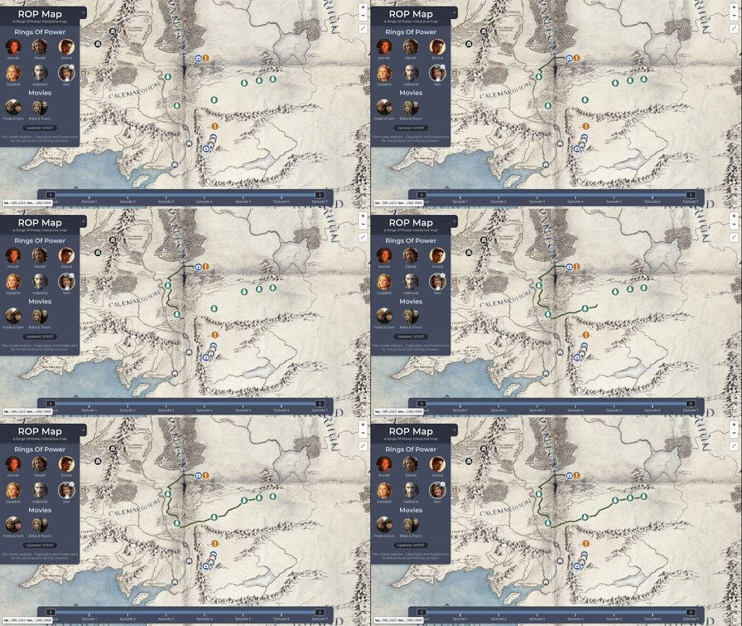
You can now also follow these Middle-earth journeys on an online interactive map. The Rings of Power Interactive Map is a very useful way to try to keep abreast of all the latest developments in Amazon's on-going series. The map features animated journey lines of some of the show's major journeys so you can follow along with the stories of Nori, Galadriel, Halbrand, Elrond, Elendil and Arondir. 

The map also includes a handy episode timeline which allows you to follow these individual journeys episode by episode.  If you select an individual episode on this timeline the map highlights the important Middle-earth locations featured in that episode. If you click on these location map markers you can learn more about each featured location. 

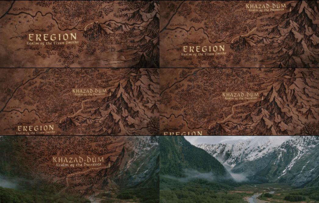
One of the many highlights from The Rings of Power have been the sumptuous and sweeping transitions from a map of Middle-earth straight into filmed (CGI) footage of the actual Middle-earth landscapes.  For example (shown above) in episode two when Elrond and Celebrimbor travel from Eregion (the Realm of the Elven Smiths) to Khazad-dûm (the Realm of the Dwarves) the journey is shown on a Tolkein inspired map of Middle-earth. 

If you want to explore these locations for yourself then the LOTR Project is another fantastic resource. The interactive map on the LOTR Project uses place names from the Third Age. The Rings of Power is set in the Second Age and many of the place-names used during this era have long since gone out of use by the time of the Third Age. 

For example Khazad-dûm is labeled Moria on the LOTR Project map (in the Second Age the dwarves were forced to leave Khazad-dûm. Subsequently this dark, empty underground kingdom became known as Moria, the Black Pit). Therefore if you want to find Khazad-dûm on the LOTR Project interactive map you need to search for Moria (the elven realm of Erigion can be found directly to the west of Moria on the map).  

If you want to have a better sense of the many locations featured in all the episodes of the House of the Dragon then you can refer to HBO's own interactive Map of Westeros. The first two episodes take place mainly at King's Landing. If you click on King's Landing on the interactive map you can learn more about some of the key locations in the capital city of the Seven Kingdoms. 

In the second episode Prince Daemon has taken up home at Dragonstone. A key scene of episode two takes place on Dragonstone, which you can find on the HBO map north-west of King's Landing at the entrance to Blackwater Bay.

Friday, January 14, 2022

The Witcher Interactive Maps

If you have been watching series 2 of the Witcher on Netflix then you might be interested in browsing these Witcher interactive maps. The Witcher novels and television series take place on the fictional land of Continent, mostly in the Northern Kingdoms region. 

Netflix's The Witcher: Welcome to the Continent is probably the most atmospheric interactive map that I have seen of the Continent. It is covered in an animated fog and other special effects. The map also includes a timeline which means that this map allows you to explore the Witcher world both by location and by chronology. 

Using the interactive map you can select individual locations in the Continent to learn more about the role that they play in the Witcher story. The timeline at the bottom of the map can be used to learn more about important events in the unfolding story of the Continent, beginning with the Conjunction of the Spheres, the mysterious event that led to the arrival of humans and monsters on the Continent.


The Witcher website also features a lovingly crafted interactive map of the medieval fantasy world created by the Polish author Andrzej Sapkowski. 

Zoom-in on Novigrad on this map and you can actually watch the smoke rising from rooftop chimneys. Zoom-in on Kaer Morhen and you can see the waves rippling on the lake. Elsewhere on the map you can find birds flapping their wings, moving windmills and even animated sea monsters.

Monday, January 18, 2021

The Relaxing World of Slow TV

Back in 2011 the Norwegian public service broadcasting company NRK broadcast live and non-stop the 134 hour long voyage of the cruise liner Hurtigruten, as it sailed around the Norwegian coastline. On the NRK website as well as watching the amazing live footage of the cruise you could also keep track of the position of the liner on a live real-time Google Map.

Slow television is the term used for these types of live 'marathon' television shows covering an ordinary event in its complete length. The Hurtigruten cruise wasn't the first 'slow television' broadcast by NRK (it had previously broadcast a number of films of complete train journeys). However the Hurtigruten broadcast in particular received a huge international following on the NRK website.

There is something extremely relaxing and meditative about most slow TV events. At a time when many of us are feeling more stressed and more confined than ever before I feel that watching slow TV can be an amazing way to unwind and adapt to the slower pace of life which Covid-19 is forcing upon so many of us.

If you need to relax then might I reccomend the Slow TV Map, a fantastic interactive map providing links to slow TV videos which have been filmed around the world. My smart TV is currently showing a ten hour hour long broadcast of a journey on the incredible Wuppertal Suspended Monorail in Germany. If suspended monorails aren't your cup of tea then you can use the Slow TV Map to discover calming videos of hikes in nature, beautiful car journeys, amazing train journeys, relaxing canal trips and aerial flights. The map even includes a filter control which allows you to filter the map to only show particular types of slow TV.

Friday, October 09, 2020

A Tapestry of Thrones

The Northern Ireland Game of Thrones Tapestry is a giant, 77 metre long medieval wall hanging, which depicts the whole epic tale of George R. R. Martin's fantasy novels in tapestry form. This huge hand-woven and hand-embroidered tapestry was created by a team of artists and illustrators. 

The tapestry is owned by the Ulster Museum Belfast but you can view it online at Northern Ireland Game of Thrones Tapestry. The tapestry is presented here in the form of an interactive map, allowing you to pan around the whole 77 meters of tapestry and to zoom into any of the details which catch your eye. 

The tapestry is organized in chronological order and depicts events from every single episode of all eight seasons of the Game of Thrones television series. As you pan around the tapestry the map tells you which season and episode you are currently viewing. The tapestry map also includes markers which provide more detail on key events depicted in the tapestry. However any fans of the television series will probably easily recognize all the scenes depicted - from the beheading of Ed Stark to the second coming of Jon Snow.

Monday, January 13, 2020

The Witcher Interactive Map


The Continent is a medieval fantasy world created by the Polish author Andrzej Sapkowski. It is the fictional realm where his Witcher series of novels take place. The Witcher is set on the 'Continent', mostly in the Northern Kingdoms region.

To accompany its new television series 'The Witcher' Netflix has released an interactive Map of the Continent. Netflix's map owes much in style to the fantasy maps developed for other fictional works, such as the Lord of the Rings and Game of Thrones. This includes the use of florid fonts and topographic features. The map itself should provide a useful guide for those who are following the television series. It allows you to search the Continent by major events in the television series and by place-name.


The Witcher website also features a lovingly crafted interactive map of the Continent. The Witcher fictional world map includes some wonderfully detailed animated elements. For example, if you zoom-in on Novigrad you can actually watch the smoke rising from the buildings' chimneys. Zoom-in on Kaer Morhen and you can see the waves rippling on the lake. Elsewhere on the map you can find birds flapping their wings, moving windmills and animated sea monsters.

Monday, June 10, 2019

A Game of Thrones Distance Calculator


The Game of Thrones Distance Calculator can tell you the distance between any two points in Westeros. This allows you to work out how far all the different characters in George R. R. Martin's classic epic have traveled throughout the various episodes and seasons.

The map was created by Mark Alicz based on clues gleamed from George R. R. Martin's novels. Jon Snow's closest friend, Samwell Tarly, tells us in 'A Storm of Swords' that the Wall is "a hundred leagues long." Martin himself tells us that 'a league is three miles'. Therefore the Wall is three hundred miles long. Mark Alicz can therefore use the length of the wall to calculate all the distances between different points on a map of Westeros.

If you click twice on the Game of Thrones Distance Calculator an information window will open revealing the distance between the two points. So, for example, the well trodden journey between Winterfell and King's Landing is 1645.29 miles as the dragon flies.

According to Google Maps this walking route from Paris to Moscow is 1,718 miles (so slightly longer than the journey between Winterfell and King's Landing). Google says this walk would take 563 hours. So if you walked 10 hours a day it would take you 56 days to complete the journey. When Robert Baratheon, the Lord of the Seven Kingdoms of Westeros, arrives in Winterfell his wife, Cerci, complains "We’ve been riding for months now, my love. Surely the dead can wait". Obviously the king traveled with a large, slow moving caravan and presumably spent many leisurely hours dining along the way. I can well believe it would take the king and his caravan a few months to travel 1,645 miles along the Kingsroad (BTW the journey on from Winterfell to Castle Black at the Wall is 2,199 miles long - so the Kingsroad itself is at least 3,800 miles long).

Of course the Game of Thrones Distance Calculator relies on the accuracy of the Westeros map. We have no way of knowing how accurate the map is. We might also do well to heed the words of George R. R. Martin when he said,

"I have deliberately tried to be vague about such things, so I don't have obsessive fans with rulers measuring distances on the map and telling me Ned couldn't get from X to Y in the time I say he did.
However, if you really must know, you can figure out the distances for yourself. The Wall is a hundred leagues long. A league is three miles. Go from there.
But if you turn up any mistakes in travel times by using that measure, let it be your secret".

Monday, April 29, 2019

A Geography of Thrones Game


How well do you know A Game of Thrones?

You might be able to tell the difference between a White Walker and a Wildling but can you point to where the Wildling's most permanent settlement is on a map of Westeros? A new interactive map game from Carto will test how well you know the geography of Westeros and Essos?

Let's put your Ice & Fire knowledge to the test with the Geom of Thrones game. In this Game of Thrones map trivia game you need to identify locations on an unlabeled map of Westeros and Essos. For example you might be asked to identify the city who's chief export are bedslaves trained in 'The Way of Seven Sighs.' All you need to do is click on the location of the city on the interactive map.

Get a question right and you are awarded 100 points and you progress to the next question. Get a question wrong and you will have points deducted from your overall score. There are five questions in all.

If you want to create your own interactive Game of Thrones map game then you might want to have a look at Carto's Game of Thrones Basemap of the Seven Kingdoms. This Game of Thrones basemap layer provides a great canvas on which you can add all of your Games of Thrones geo-data.

Friday, April 12, 2019

A Street View of Thrones


A Viz of Thrones is a map and data visualization about the characters and episodes of the HBO series Game of Thrones. The map allows you to view the setting in Westros or Essos where every single scene in all seven screened seasons of A Game of Thrones takes place.

At the heart of a Viz of Thrones is a mapped timeline which allows you to drill down into any scene, in any episode of all seven screened seasons of the television series. If you select an episode from the season timeline then the map sidebar will show all the individual scenes in that episode. Select any scene in the chosen episode and character markers will be added to the interactive map. The map therefore shows you both the location of the chosen scene and the characters who appear in it. If you click on a character's marker on the map you can even find out the length of their screen time in the chosen scene.


If you enjoy exploring these fictional locations on the interactive map then you might like to explore the real locations where these scenes were shot using Google Maps Street View. In Game of Thrones: The Old Views and the NewGoogle has curated a collection of Game of Thrones shooting locations which can be explored using Google Maps panoramic imagery. The collection includes the real shooting locations for King's Landing and Winterfell. Google's collection of magical Street Views is split into three main Houses, the Starks, Lannisters and the Mother of Dragons.


If you are impressed by A Viz of Thrones then why not create your own interactive Game of Thrones map. Thanks to Carto you don't even need to create your own basemap of Essos and Westeros. Carto's Game of Thrones Basemap of the Seven Kingdoms provides a great canvas on which you can add all of your Games of Thrones geo-data.

If you want to know how to add all your GoT geo-data to the Carto basemap then you need Patrick Triest's tutorial Building Aa Interactive Game Of Thrones Map (Part I) - Node.js, PostGIS, and Redis. The first installment of this two part tutorial explains how you can build a searchable backend to serve your data to the map. Part II of the tutorial shows you how to build a responsive interactive map for this data using Leaflet.js.

If you were wondering what a Node.js, PostGIS, and Redis powered Game of Thrones map looks like then you can find out on Patrick's Atlas of Thrones. The map includes lots of categorized points of information that you can view on the map. Including castles, towns, regions and landmarks. You can navigate to these via the categorized menu or by using the built-in search function.

Saturday, February 16, 2019

Amazon's Lord of the Rings Map


Amazon is busy creating a Lord of the Rings Prime Video series. Little is known about the television series, as of yet, but there is a Lord of Rings on Prime official Twitter account. On Wednesday that account made it's first Tweet, which was a short Tolkien quote,


Yesterday that Tweet was followed up with a link to an Amazon Prime interactive map of Middle Earth. The Amazon Prime map is a neat representation of Middle Earth, although it doesn't contain any place-name labels. The map does include a few fantasy map staples, such as a vintage looking compass rose, tattered edges and fold marks. There is also a download link which allows you to save the map as an image file.

This blank interactive map of Middle-Earth is an interesting marketing ploy, which is obviously little more than a teaser for the Amazon Prime television series. If you are a real fan of Tolkien's novels then you will probably have more fun exploring the interactive maps created by the LOTR Project. These include interactive maps of both Beleriand and Middle Earth.

The LOTR Project interactive maps include place-name labels and lots of optional layers which allow you to overlay time-lines, route and events from Tolkein's novels directly on top of the interactive maps.

Wednesday, January 10, 2018

The Dunder Mifflin Office


Over the years there really haven't been enough interactive maps of television studios sets. The nearest thing we've come to this in the past has been the Interactive Simpsons Story Map, which introduces the cartoon's main characters and shows where they live on an interactive map of Springfield.

However the wait for a proper interactive studio set map is now over, thanks to Michael Scott's Dunder Mifflin Office Map. This interactive map of the Scranton, Pennsylvania branch of Dunder Mifflin provides an interactive floor map of the desks, offices, toilets staff room and other amenities which can be found in one of the world's most famous work places. What's more the map is also fully searchable. If you want to know where your favorite character sits in the Scranton office then you can enter the character's name and the map will automatically zoom in to show you their desk on the office floor plan.

As fun as the Dunder Mifflin Office Map is the map actually has a serious purpose. The map is a demonstration of the Office Floor Plan Navigator. This GIS application is designed to help create interactive floor plan maps. The application "takes indoor building floor plans and turns them into an interactive mapping platform allowing you to assign a location to anything from your favorite pen to a meeting room".

If you want to see another demonstration of the Office Floor Plan Navigator in action then check out this interactive map of the set from the television drama Suits.

Wednesday, September 06, 2017

Roll Your Own Game of Thrones Map


It has never been easier to create your own interactive Game of Thrones map. Thanks to Carto you don't even need to create your own basemap of Essos and Westeros. Carto's Game of Thrones Basemap of the Seven Kingdoms provides a great canvas on which you can add all of your Games of Thrones geo-data.

If you want to know how to add all your GoT geo-data to the Carto basemap then you need Patrick Triest's tutorial Building Aa Interactive Game Of Thrones Map (Part I) - Node.js, PostGIS, and Redis. The first installment of this two part tutorial explains how you can build a searchable backend to serve your data to the map. Part II of the tutorial is due next week. This second part promises to look more at the actual mapping side of building an interactive Game Of Thrones map,

If you were wondering what a Node.js, PostGIS, and Redis powered Game of Thrones map looks like then you can find out on Patrick's Atlas of Thrones. The map includes lots of categorized points of information that you can view on the map. Including castles, towns, regions and landmarks. You can navigate to these via the categorized menu or by using the built-in search function.

Tuesday, August 08, 2017

A Game of Thrones Filming Locations


It is said that long ago, before the Doom when dragons still flew above the towers of Tyria, Valyrian wizards could use the magic of obsidian candles to see across vast distances. A wizard could light a candle in the Valyrian Freehold in Essos and instantly spy on the Hand of the King, across the Narrow Sea in the Red Keep of King's Landing.

With the rebirth of the dragons the magic of obsidian candles is active once again. To use this ancient magic you must own the ancient scroll called Game of Thrones Filming Locations in Causeway Coast and Glens. Used properly the spells in this ancient text can instantly transport your sight to the Dothraki Grassland, the Coast of Dorne, the Stormlands or to many other locations throughout the lands of Westeros and Essos.


Dragonstone, as shown with dragon's view on the magic map of Esri

Each location that your inner vision visits is highlighted upon the magic map of Esri and shown from above with magical 'dragon's view' images. The magic map of Esri also includes ancient words of wisdom about each of the locations that you visit on your magical journeys. These words of old provide a brief history of each location and the role it has played in the long history of this Land of Ice and Fire.


There is also an ancient spell of 'Street View' which can bestow the gift of long vision onto anyone who owns the 'Map of Google'.

Game of Thrones: The Old Views and the New gives you the vision to stare straight as the dragon flies into King's Landing, Winterfell or the mysterious continent of Essos. Google's collection of magical Street Views is split into three main Houses, the Starks, Lannisters and the Mother of Dragons. This allows you to direct your gaze to any of your favorite locations on either of the continents of Essos or Westeros.

If you wish to explore the lands of A Game of Thrones even more then you might also want to consult The Five Maps of Westeros.

Thursday, July 20, 2017

A Game of Thrones Street View


What could be better than exploring A Game of Thrones on the Five Maps of Westeros?

How about a world tour of some of the amazing real-life filming locations where the television series was made?

One reason for the huge success of HBO's series of George R.R. Martin's best-selling 'A Song of Ice and Fire' is the amazing set locations. HBO scoured the planet to find suitable locations to represent King's Landing, Winterfell and Essos. Google has put together a collection of filming locations from A Game of Thrones which appear on Google Maps Street View. The collection takes you on a tour of beautiful locations in Ireland, Croatia, Iceland, Spain and elsewhere around the world.

Game of Thrones: The Old Views and the New allows you to explore the filming locations for King's Landing, Winterfell and the mysterious continent of Essos. Google's collection is split into three main Houses, the Starks, Lannisters and the Mother of Dragons.

The Google Earth Blog has used Google's collection of Street Views to put together a Game Of Thrones kml file which allows you to explore these filming locations in 3d on Google Earth.

Tuesday, July 18, 2017

The Five Maps of Westeros


Interactive maps of Westeros seem to get cut down and eviscerated as often as the Hands of the King. As yet another new season of a Game of Thrones begins it is time once again to take stock of our favorite interactive maps of George R. R. Martin's fantasy world.

Web of Allegiances is an interactive map of Game of Thrones which shows you where the Great Houses reside and the many entangled pacts and allegiances between them. You can select any of the characters on the map to view their name and the Houses that they are allied to. You can also click through to learn more about the character on the Games of Thrones wiki.


Last year A Song of Ice and Data emerged from Beyond the Wall to shed new light on Westeros & Essos. A Song of Ice and Data is a new REST API, interactive map and data store created by students at the Technical University of Munich. Most of the data for the project has been scraped from the Wiki of Ice and Fire.

The Song of Ice and Data interactive map shows the lands, borders and cities of the Known World. It also includes travel paths of all the major characters. If you select any of the marked locations on the map you can learn more about the location from the Wiki of Ice and Fire. If you want to view a character's travel path on the map just search for the character using the map's search box.


The Interactive Game of Thrones Map is another map of the fictional continents of Westeros and Essos from George Martin's series of fantasy novels A Song of Ice and Fire.

The map features all the locations from the television series and books. The map also allows you to follow the journeys of all the main characters through the different seasons. To view a character's path select their name from the map sidebar and use the timeline slider control.


The Westeros Map is another Google Map of the fictional continent of Westeros from George Raymond Richard Martin's A Song of Ice and Fire fantasy novels. This map shows important locations on the continent of Westeros. Clicking on the locations on the map will take you to that location's wiki entry.


Game of Thrones is an Esri StoryMap of Westeros and Essos. The map sidebar includes links to important locations on the two continents. If you zoom in on the map the sidebar updates to show links to important locations in the current map view. A drop-down menu also provides quick links to view important regions on the map.

The reason for all these maps is undoubtedly the popularity of George R. R. Martin's A Song of Ice and Fire series of novels and HBO's popular Game of Thrones dramatization of this series. However these interactive maps also owe a huge debt of gratitude to Jonathan Roberts' official maps of Westeros and Essos, based on George R. R. Martin own hand-drawn maps.


When compiling a list of interactive maps of fictional worlds it would be remiss not to add a quick link to the LOTR Project's interactive Map of Middle Earth. This interactive map of J.R.R. Tolkein's fantasy world is the original interactive fictional map and still takes some beating.

Thursday, April 20, 2017

30 Years of The Simpsons


The Simpsons are celebrating their 30th anniversary. The first ever short episode of The Simpsons appeared on The Tracey Ullman Show on April 19, 1987. Remarkably Bart Simpson doesn't look a day older now than he did in that first ever episode.

A new Esri Story Map of Springfield has been released to celebrate this 30th anniversary. The map not only allows you to explore America's most famous town but also includes a wealth of information about the show and all the main characters. As you progress through the Interactive Simpsons Story Map you are introduced to the show's characters and also shown where they live on the Springfield map.

You can also explore the map yourself. If you click on any of the colored building footprints on the map an information window will open with a description of the selected building.


The Simpson's City Map provides a bird's eye view of Springfield. This map allows you to explore an oblique view of Springfield and view places of interest in the town, such as the home of the Simpsons family (742 Evergreen Terrace) and the location of the.world's first ever Kwik-E-Mart.

If you select a marker on The Simpson's City Map you can learn more about some of the town's most important locations, The Simpson's City Map also include an attempt to crowd-source information. If you have information about a building on the map you can press the 'contribute' button to submit your own knowledge about the town of Springfield.

Tuesday, June 21, 2016

Sigur Rós - Summer Solstice Tour of Iceland


Sigur Rós – Route One is a live 'slow TV' event, which for 24 hours will be live broadcasting a summer solstice journey around Iceland. Rock band Sigur Rós are currently driving around Iceland's 1,332km long coastal ring road and broadcasting the whole event on YouTube.

If you visit the Sigur Rós – Route One website you can watch the live stream of the event and view the band's real-time position on a Google Map. I actually suspect that the band members themselves are not participating in the actual drive. However the live stream of the journey does include a Sigur Rós soundtrack.

The soundtrack is being created live by generative music software using elements from the Sigur Rós' song 'óveður'.

Thursday, April 28, 2016

Mapping the Simpsons


PlayGIS's Springfield is a gloriously detailed map of America's most famous town. The map allows you to explore an oblique view of Springfield and view places of interest in the town, such as the home of the Simpsons family (742 Evergreen Terrace) and the location of the.world's first ever Kwik-E-Mart.

The Springfield map was created using the Esri mapping platform. It is now also available as a Leaflet powered map. The Simpson's City Map is an attempt at directly port (plagiarize?) playGIS's map into Leaflet.js.

The new Simpson's City Map includes the same map tiles and even the same marked locations and town information as the playGIS map. In fact the Simpson's City Map doesn't appear to have created quite as many layers of map tiles as playGIS, therefore it doesn't have the same quality when you zoom in on the map of Springfield.

The new Simpson's City Map does include an attempt to crowd-source information about the town of Springfield. The map includes a 'contribute' button. Press this button and you are taken to another Springfield map with an e-mail address for contributing information about locations on the map.