Showing posts with label bookmaps. Show all posts

Tuesday, August 12, 2025

The Map to Your Heart

I have become a little obsessed with Mark Sample's No Time to Discourse, an interactive map that procedurally generates climate-disaster microfictions and pins them to locations across the United States. 

Mark's map inspired me to create MultiVerse - a small interactive map that generates a poem for any location a user chooses. That experiment has now led me to my latest project: a location-based love-story generator.

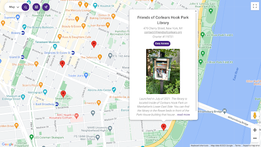
Meet Cute is a playful way to imagine romance in the places you know best. Using its interactive map, you choose a location - your hometown, your favorite vacation spot, or even a city you’ve never been to - and watch as a unique micro love-story is generated set in your chosen location.

Behind the scenes, the Overpass API is used to find a town near the user's clicked location and then a custom RiTa.js grammar weaves together character names, settings, and love obstacles - all tied to the town you selected.

At its heart, Meet Cute’s grammar follows a simple love-story arc: two people meet, an obstacle comes between them, and that obstacle is either overcome… or not.

I was also interested in seeing if AI could do a better job at generating micro-fiction love stories. I therefore fed Google AI Studio the prompt 'Create an interactive map. When a user clicks on the map write a micro-fiction love-story based on that location'. In response to my prompt Google AI Studio created this Map of Love Stories (you may need to connect with a Google account to see the map).

I think that this is a very impressive result from such a simple prompt. I am sure it could be improved beyond recognition by giving AI Studio further prompts - possibly about additional map features and the structure of the created love-story.

Monday, August 04, 2025

Mapping the MutiVerse

Every town, every mountain, and every quiet river had its own poem waiting to be discovered. 

Meet MultiVerse - an interactive map where a single click anywhere in the world generates a unique poem inspired by that location. From the bustling streets of Tokyo to the silent hills of the Scottish Highlands, MultiVerse lets you explore not just geography, but language, emotion, and imagination.

Why?

On Saturday, I stumbled upon No Time to Discourse, an interactive map that procedurally generates climate disaster micro-fictions and pins them to a map of the United States. In my review, I pointed out that it never actually used real place names in its stories. So, to be fair, I wanted to see if it was even possible to create procedurally generated literature that truly came from any place on the map. The result is MultiVerse.

✨ How It Works

MultiVerse blends real-world location data with a language engine to craft poetry that changes as you roam the map. Under the hood are two main drivers:

1. Overpass API: Finding the Soul of a Place

When you click on the map, MultiVerse needs to know where you are. That’s where the Overpass API comes in.

  • Overpass is a query engine for OpenStreetMap (OSM) data.

  • When you click the map, MultiVerse sends a request asking: “What’s the nearest town, village, or city to this point?”

  • The API responds with details about the location, such as its name.

This means that every poem is tied to a real place. If there’s an OSM record, MultiVerse can find it.

2. RiTa.js: The Language Engine

Once MultiVerse knows where you clicked, it turns that location into verse using RiTa.js, a JavaScript library for generative language.

  • RiTa uses grammars - sets of rules that describe how words can combine.

  • MultiVerse feeds the location name into a grammar and then generates a short poem.

  • The result might look something like:

    Winter gentle breeze  
    Wakes softly in Kyoto’s streets  
    Fading with the dusk
    

Because the grammar is flexible and randomized, each poem is (largely) unique - and each town can have hundreds of possible variations, each offering a new way of seeing the place.

I say “(largely) unique” because MultiVerse uses a set of rules that randomly combine adjectives, verbs, and nouns. At the moment, my MultiVerse grammar (set of rules) and vocabulary (word dictionary) are quite limited, so you will probably notice some repetition in the poems it generates. However, the beauty of RiTa.js is that you can easily expand the grammar rules and the vocabulary data. With a larger vocabulary and a more complex grammar, the chances of spotting repetitive patterns would drop dramatically.

Feel free to create an improved version of MutiVerse yourself by forking it on GitHub.

Wednesday, July 30, 2025

The Global Movie Map

Over the years, there have been a number of interactive maps that have plotted movies and TV shows based on where they were shot or set. There have also been several attempts to map novels by their settings.

StoryTerra takes this idea further - it maps movies, television dramas, and novels all in one place!

Zoom in on any location in the world on StoryTerra, and you can discover which movies and novels take place there. Thanks to a hierarchical location system (e.g., Paris → Île-de-France → France), you can explore at any scale, from a single city to an entire country. Each novel or movie set in the selected location appears as a color-coded card in the map sidebar, and you can click on these cards to read a synopsis of the selected title.

StoryTerra also has a powerful timeline feature. This allows you to filter results by centuries, decades, or even individual years. Whether you’re curious about ancient China or 1940s France, you can see exactly which stories align with that period. (Note: items appear to be mapped according to the date when they are set, rather than when they were written or released.)

The data for the map comes from publicly available datasets of books, movies, and TV shows. However, each item had to be manually checked for its setting and time period. Currently, there are just over 100,000 mapped items. Because of this careful curation process, some popular titles may not appear on the map.

For example, clicking on Brighton, UK, brings up around 40 results - a fair number. However, I can think of three classic movies set in Brighton, and one of them is missing. While StoryTerra includes Brighton Rock and Genevieve, the iconic Quadrophenia is absent from the map’s list of Brighton-based stories.

Although StoryTerra does not give a definitive list of TV shows, movies or novels set in a chosen location it does normally provide a reasonable selection of results. For me, that’s enough. When I travel, I enjoy reading novels set in my destination (both before and during the trip). I can definitely see myself using StoryTerra before visiting a new location to find movies to watch and novels to read that will help me connect with my holiday destination.

Monday, October 30, 2023

The Little Free Library World Map

I shall be eternally grateful to my local community's book sharing box. As an avid reader being able to borrow and read secondhand books during lock-down kept me from becoming completely stir crazy. Since lock-down my nearest book-sharing box has almost fallen into disuse. Which is why I'm delighted to have found the Little Free Library World Map.

The Little Free Library World Map is an interactive map showing the locations of book-exchange boxes around the world. The map was created by the Little Free Library non-profit of Minnesota and has now mapped over 150,000 libraries in 120 different countries. 

Share your location with the Little Free Library World Map and you can find the nearest book-exchange boxes to your home. The locations of individual free libraries are displayed on the map using red map markers. If you click on a marker you can view the library's exact address and information on exactly where you can find this book-exchange box.

I'm lucky enough to have two boxes within walking distance of my home. If there are none near you there is no need to despair. Instead you can set up your very own Little Free Library. All you really need to start a free library is a weather-proof container in which people can leave books they wish to share. If you need help creating such a container then you can check out the Start a Little Free Library web page.

If you live in London or Brighton then you might also be interested in the Library of Things, which allows you to borrow/rent tools (such as drills, sewing machines etc).


Thursday, June 01, 2023

Mapping 1,001 American Novels

1,001 Novels: A Library of America is an interactive literary map of America. A map on which over one thousand novels have been plotted based on the geographical 'heart' of each story. 

'1,001 Novels: A Library of America' is a project of love created by Susan Straight, a novelist and professor at UC Riverside. Over the course of five years, Susan read and mapped 1,001 novels set in the United States. The resulting interactive map allows you to explore American novels by region, plot, and theme.

Straight's goal in mapping over one thousand American novels was to "tell the story of America through its literature." She believes that novels can provide a unique window into the lives of people from different parts of the country and different eras. By mapping the novels, Straight also hoped to create a tool that can help readers discover new books and learn more about the history and culture of the United States.

As a result of reading and mapping 1.001 American novels Susan developed a sense of 11 distinct regions in the United States. These regions are based on the physical geography of the United States, as well as the cultural and historical traditions of each region. In the Esri Story Map 1,001 Novels: A Library of America you can explore each of these 11 regions and the novels that are set in each region. Susan Straight believes that these regions provide a unique lens through which to view American literature. By exploring the novels set in each region, it is possible to gain a deeper understanding of the diversity of American life and culture.

The Esri Story map also includes a complete map of all 1.001 novels set across all regions of the United States. The location setting in each novel has been determined by references in the books themselves, from what authors have said and from asking some of the authors themselves where they believe the heart of their books might be.

Tuesday, May 02, 2023

The Map of 52,000 Books

A Visual Book Recommender is an interactive map of 51,847 books organized by similarity. Using the map you can discover new books to read by searching for your favorite books and exploring other 'similar' nearby books.

Books are shown on the map using their cover sleeves. If you click on a book's cover on the map an information window will open containing a short introduction to the novel's plot. The map also comes with a handy search option which allows you to enter the title of a book and zoom to that book's location on the map. All the nearby books on the map are then likely to be fairly 'similar'.

It is also possible to search the map by genre. The map's creator has also made a handy genre map which allows you to select individual genres (e.g. Sci-Fi, Crime, Romance etc) to see where these types of books are clustered on the map.

The map was created from scraping book reviews. Books are clustered on the map based on reviewers liking the same books. For example if lots of reviewers liked book A and book B then those two books are very likely to appear near each other on the map. The actual clustering algorithm is a lot more complicated than that and is explained in a lot more detail in a 'technical details' section beneath the map. 

In 2019 The Pudding created a very similar interactive map from the covers of 5,000 books. However on The Pudding's map all the books were arranged by their visual similarity. 


All 5,000 books mapped on 11 Years of Top-Selling Book Covers, Arranged by Visual Similarity have appeared on the New York Times' 'Best Selling' or 'Also Selling' lists since June 2008. Color seems to play a very prominent role in determining 'visual similarity' in the machine algorithm used by The Pudding. If you zoom out so that you can see all 5,000 book covers you can see that a lot of the grouping and organization appears to be strongly influenced by the dominant color of each book. 

The Pudding's map comes with a number of filters which allow you to explore the book covers by genre and by visual motif. The visual motif filter allows you to highlight on the map images which contain 'faces', 'landscapes', 'smiles' etc. Therefore the motif filter provides another way to explore the book covers by visual similarity.
An Ocean of Books is an interactive map of over 100,000 authors and 145,162 books. On this map every island is an author and every city is a book. If you search the interactive map for your favorite writers you can find other writers that you may enjoy based on how near they appear on the map to your favorites.

The size of an author's island on An Ocean of Books is determined by the amount written about them on the internet. The more times they are mentioned on the world wide web then the bigger their island on the map. The position of the islands and the proximity of authors to each other is determined by the number of connections between them on the internet. If two authors are mentioned in lots of the same articles on the web then the closer they will be on An Ocean of Books.

The connections between authors and therefore their proximity on the map is determined by a machine learning algorithm. If you select an author's name on the map then you can read a short biography. If you zoom in on an author's island then all the writer's books will appear as cities on the map. Click on a book's title and you can read a short introduction to the selected book.

Friday, December 09, 2022

The Map of Stories

The Map of Stories is a fantastic interactive map which allows you to discover and listen to tales from the highlands and lowlands of Scotland. Using the the you can explore the rich oral storytelling traditions of Scotland and listen to stories born from the landscapes and people of Scotland.

Using the map you can browse over 70 stories by story location or by storyteller location. The map also includes controls which allow you to filter the stories shown by language (English, Gaelic or Scots) and by category.

The stories found on the map come in many forms. Many of the stories emerge from indigenous  communities, traveller communities and from the Shetland Islands. Others come from Scotland's migrant communities, from countries as far away as India and Iran. However, no matter their origin, all the stories can be listened to simply by clicking on its marker on the map.

Sgeulachdan na Mara / Sea Stories - an online cultural map of the sea is a wonderful interactive map featuring local stories found around the island of Barra, in the Outer Hebrides of Scotland.

To create the map the island's school pupils interviewed local Barra fishermen and older members of the local community. The result is a unique map featuring local legends and oral history as told by the islanders themselves. You can watch and listen to the videos and audio recordings resulting from the interviews directly from the Sea Stories map.

The map legend allows you to highlight on the map where audio, video, photographs or text are available to be viewed. These media are shown on the map using a number of different types of marker, indicating stories about wrecks, fishing, coastal features etc.

There is a lot to love about this map, not least the wonderful cartography of the vintage style map of Barra. The real stars of this map, however, must be the islanders of Barra. There are at least two Gaelic folk song recordings on this map which are worth the price of admission (there is none) on theur own.

Friday, January 28, 2022

The Map of All Human Knowledge

Open Syllabus Galaxy is an interactive map which allows you to search the 1,138,841 most frequently assigned texts in University syllabi. On the map university and college text books are organized spatially based on which books and articles are assigned together in the same courses. 

Open Syllabus is is a non-profit research organization that researches the syllabi of University and College subjects. As part of this analysis Open Syllabus uses machine learning and other techniques to collect the titles of texts and articles cited on reading lists in course syllabi.

Open Syllabus Galaxy maps over 1 million assigned college tests based on 'co-assignment patterns' (i.e. which tests are listed in the same syllabi). The interactive map plots over 1 million of the most frequently assigned texts in higher education. Individual texts are shown on the map using scaled colored circles. The colors of the circles relate to college subjects (which subject a text is most assigned in). Texts colored grey are interdisciplinary texts (these texts have <50% of assignments in any single subject). The scale of the circle markers are determined by the number of syllabi a text is listed in. Therefore the biggest circles show the texts which are on the most subject reading lists. 


The HathiTrust Digital Map is a similar interactive map which allows you to browse and explore the 14 million volumes in the HaithTrust's repository of digitized texts. The HathiTrust is a partnership of academic and research institutions which offers a collection of millions of titles digitized from libraries around the world.The HathiTrust Digital Map provides a visual interface with which you can navigate the books in the HaithiTrust digital library.

The Library of Congress Classification system categorizes books into different broad subjects and then by sub-classes within each of these subjects. The HathiTrust Digital Map uses an entirely different method of classification. On this interactive maps texts are organized by the similarity in the vocabulary of individual texts.

The interactive map has two distinct modes: 'Read' and 'Interact'. If you select 'Interact' you can zoom in and pan around the map. If you then select an individual dot on the map you can actually open the selected text on the HathiTrust Digital Library website. However if you select 'Read' you can learn more about the vocabulary similarity classification system used by the digital map.


An Ocean of Books is an interactive map of over 100,000 authors and 145,162 books. On this map every island is an author and every city is a book. If you search the interactive map for your favorite writers you can find other writers that you may enjoy based on how near they appear on the map to your favorites.

The size of an author's island on An Ocean of Books is determined by the amount written about them on the internet. The more times they are mentioned on the World Wide Web then the bigger their island on the map. The position of the islands and the proximity of authors to each other is determined by the number of connections between them on the internet. If two authors are mentioned in lots of the same web pages then the closer they will be on An Ocean of Books.

The connections between authors and therefore their proximity on the map is determined by a machine learning algorithm. If you select an author's name on the map then you can read a short biography. If you zoom in on an author's island then all the writer's books will appear as cities on the map. Click on a book's title and you can read a short introduction to the selected book.


TheLibraryMap uses the idea of fictional genres as its organizing principle in mapping books. TheLibraryMap is an interactive map of over 100,000 books which are organized based on 'the genre and topics of each book'. On the map individual books are colored by 'genre and topics'. 

Individual book markers on the TheLibraryMap are also sized differently. The size of a book marker is related to the number of 'user reviews' (TheLibraryMap is a participant in the Bookshop.org affiliate program so I assume this relates to user reviews on Bookshop.org).

Thursday, May 20, 2021

Placing Poems in Ireland


During lock-down most of us had our personal geographies curtailed. However physical restrictions on our movements didn't stop us thinking about far away places and people. In April Irish poet Roan Ellis-O’Neill asked the people of Ireland to write a poem about an imagined journey "away from the stifling reality of the pandemic". The result is the Placing Poems interactive map.

Placing Poems features poems about locations across the whole of Ireland. Each of the poems was submitted by a member of the public. The deadline for submitting poems has now passed but you can read the poems which were submitted simply by clicking on any of the markers on the Placing Poems interactive map. 


In 2019 a similar public art project was carried out in England & Wales. Places of Poetry was devised to inspire the English and Welsh to write poetry about the places that inspire them. The project asked budding poets to pin their poems about English and Welsh locations directly to the Places of Poetry interactive map.

The background map used for the Places of Poetry project is inspired by William Hole's engraved maps created for Michael Drayton epic poem Poly-Olbion (1612). The new map is an original work but is heavily inspired by Hole's highly decorative and iconographic style. The Place of Poetry map includes new icons celebrating some of the UK's most well known heritage sites. These include Stonehenge, Ely Cathedral and even the Oval cricket ground. Other icons on the map (for example for forests and farming regions) are more direct copies of Hole's iconography. The marine icons of Neptune, sirens and ships are also direct copies from William Hole's engraved maps.

Friday, December 04, 2020

Living Nations Poetry

Joy Harjo is the 23rd Poet Laureate of the United States. As a member of the Muscogee Nation she is also the first Native American to hold the position of Poet Laureate. Joy's signature project as the 23rd Poet Laureate is an interactive map of the United States featuring recordings of a number of Native Nations poets and their poems.

Living Nations, Living Words - A Map of First Peoples Poetry features 47 Native Nations poets. Each of the poets has selected an original poem for the map on the theme of place and displacement. Each poet also chose where they wanted to be placed on the map. If you click on a poet's marker on the map an information window opens with a photograph, a short biography, and a link to actually hear the poet recite and comment on their original poem. 

You can also listen to each of the poems featured in the Living Nations, Living Words Collection on the Library of Congress website. The Living Nations, Living Words Collection includes a recording of each of the 47 poems in the collection and a short introduction to each of the poets.

Monday, November 16, 2020

The Island of Fiction

The Island of Fiction is an interactive map of a fictional island. On this Island of Fiction there are five states, 'Crime', 'Horror', 'Science-Fiction', 'Romance' and 'Fantasy'. In each of these five states are a number of cities, each of which is named for a best-selling author, who has written within that genre.

The idea for the Island of Fiction came from an Alan Levine article on using fantasy maps, generated by Azgaar’s Fantasy Map Generator, as the base map layer in a Leaflet.js interactive map. Essentially Alan's article explains how you can use the Fantasy Map Generator to create a fictional blank map which you can then use as the basis of an interactive concept map.

Using the Leaflet mapping library you can add markers and place-name labels to your fantasy map to create a map of any concept that you desire. Using the options in the Fantasy Map Generator I created a map with five states. In Leaflet I used the tool-tip tool to add place-name labels to these five states, naming each one for a fictional genre. I then used smaller place-name labels to name cities within each of these states, for famous authors who have published works of fiction within each genre.

My Island of Fiction was created in a couple of hours for the #30DayMapChallenge. With a little more work I think this could be a very interesting map. For example, I could add more authors to the map - so that as you zoom-in on a genre the names of more writers appear on the map. I could also make each author's name interactive - so that if you clicked on an author's name you could view a photo, biography and a list of their major works.

This concept can of course be used in many different contexts. I am sure there are thousands of different concept maps which could be created using Azgaar's Fantasy Map Generator in conjunction with an interactive mapping library.

Friday, October 09, 2020

A Tapestry of Thrones

The Northern Ireland Game of Thrones Tapestry is a giant, 77 metre long medieval wall hanging, which depicts the whole epic tale of George R. R. Martin's fantasy novels in tapestry form. This huge hand-woven and hand-embroidered tapestry was created by a team of artists and illustrators. 

The tapestry is owned by the Ulster Museum Belfast but you can view it online at Northern Ireland Game of Thrones Tapestry. The tapestry is presented here in the form of an interactive map, allowing you to pan around the whole 77 meters of tapestry and to zoom into any of the details which catch your eye. 

The tapestry is organized in chronological order and depicts events from every single episode of all eight seasons of the Game of Thrones television series. As you pan around the tapestry the map tells you which season and episode you are currently viewing. The tapestry map also includes markers which provide more detail on key events depicted in the tapestry. However any fans of the television series will probably easily recognize all the scenes depicted - from the beheading of Ed Stark to the second coming of Jon Snow.

Wednesday, October 07, 2020

Mapping Dante's Inferno


Dante's vision of Hell consists of nine concentric circles. These circles represent ever increasing levels of wickedness. Sinners in Dante's Inferno are forced to live for eternity in the circle which best fits their Earthly sins. The outside circle is Limbo, where the unbaptized and virtuous pagans are forced to reside. The ninth circle of hell is reserved for those who are guilty of treachery against their friends, families or loved ones.

This Inferno is described in Dante Alighieri's 14th-century epic poem Divine Comedy. Almost since the Inferno was first published in the 14th Century people have been attempting to map his vision of hell. One of the first maps of Dante's Inferno was created by Antonio Manetti. You can view an interactive version of his 'Section, Plan and Dimensions of Dante’s Inferno' at Cornell University Library - Digital Collections.

Manetti's schematic provides both a plan and a sectional view of Hell. It also provides the dimensions of each of the nine concentric circles.


A new interactive map Topography of Dante Alighieri's Inferno provides a more pictorial sectional view of Dante's vision of Hell. If you zoom in on this map of the Inferno you can learn more about the sinners in each circle of hell and the eternal punishments which they must endure.

For example - if you zoom in on the third circle (Gluttony) you will discover that here the gluttonous are punished by being forced to lie in "a nauseating slush under an incessant rain, while Cerberus barks above them". In the ninth circle (Treachery) those who have been treacherous to relatives are "buried up to their necks in ice".

The Topography of Dante Alighieri's Inferno is in Italian. However if you view the map in Chrome then Google's 'translate this page' option does a good job of translating the important sins and punishments into English.

Tuesday, April 28, 2020

Poems on the Subway


Queensbound is a collaborative audio project which features poetry by local writers from across the borough of Queens in New York City.

At the heart of Queensbound is an interactive subway map of Queens. All the green subway stations on the map indicate poems which you can listen to. Just click on a station marker to listen to the poem and read a short biography of the featured poet. The poems themselves seem to be roughly located to reflect the home locations of the featured poets.


Places of Poetry is a creative arts project which tried to inspire the English and Welsh to write poetry about the places that inspired them. In 2019 the project asked budding poets to pin their poems about English and Welsh locations onto the Places of Poetry interactive map.

The map is no longer accepting new poems but the map still allows you to read all the poems which were added during the project. The background map used for Places of Poetry is inspired by William Hole's engraved maps created for Michael Drayton epic poem Poly-Olbion (1612). The Places of Poetry map is an original work but is heavily inspired by Hole's highly decorative and iconographic map style.

Fans of the written word may also be inspired by the Poetry Atlas, which is an interactive map of poems written about locations around the globe.

Monday, November 19, 2018

Exploring Fictional London


Authorial London is an interactive map of references to London locations which can be found in the works and biographies of the writers who have lived there. The map allows you to explore the places where authors lived in London and the locations which they wrote about.

The map uses different colored markers to show London locations where the featured writers lived & worked (yellow) and the places that featured in their works of literature (red). This enables you to compare on the same map the locations where an author lived with the places that they wrote about. So, for example, if you select to view the London locations of Charles Dickens you can see that he lived mostly in west London but wrote mainly about poorer locations in the south and the east of the city.

You can also select to view the works and biographies of individual writers on the map. Alternatively you can select more than one writer to view where their lives or the places that they wrote about converged in London. You can also select to view all the instances where writers have written about the same location. Select 'Places' from the map sidebar and you can then choose individual London neighborhoods to view all the times that the neighborhood has featured in the literature of London.

Monday, November 12, 2018

Mapping the Norse World


The Norse World is an interactive map showing the locations mentioned in medieval Norse literature. The map is intended to be a resource for students of medieval Swedish and Danish literature and history. It provides an invaluable insight into what places were written about and how places & countries were perceived and visualized in Old Swedish and Old Danish in the Middle Ages.

If you select a marker on the map an information window opens listing all the known appearances of the selected location in medieval Norse literature. You can select the place-name itself in this list to learn more about the location and what type of locality it is. You can also select from any of the medieval texts in which the place-name appears. This will load a brief introduction to the selected medieval Norse text.

You can also use the search function to map individual works of Norse literature. For example if you search 'Ivan Løveridder' you can view all the locations around the world which appear in this medieval verse romance on the Norse World interactive map.


The medieval Icelandic family sagas are prose histories describing the lives of the first few generations of settlers in Iceland in the late 9th, 10th, and 11th centuries. The Icelandic Saga Map allows you to read each of the Icelandic Sagas alongside an interactive map showing the locations of all the places mentioned in these historic tales.

When you select an individual saga from the Icelandic Saga Map homepage you are presented with the text of the story alongside an interactive map. Locations in the saga are hyperlinked to the map. Therefore as you read the saga you can select place-names mentioned in the text to view its location on the interactive map. Alternatively you can click on the locations tagged on the map to jump to the parts in the texts where they are mentioned in the Sagas.

When reading an individual saga you can use the Sagas menu (top right) to also overlay the locations mentioned in any of the other Sagas on the interactive map.

Friday, November 02, 2018

Mapping the Great American Novel


Susan Straight has experienced all that America has to offer from the pages of the books in the Riverside Public Library. During a life spent reading she has explored the towns and cities of America. She has run through the woods of Maine, she has ridden across the prairies of Kansas and she has walked in the footsteps of the greatest characters in American literature.

Thanks to Susan Straight's The American Experience in 737 Novels you too can explore America through the pages of some of America's greatest writers. The American Experience in 737 Novels is an interactive map which plots the geographical settings of 737 American novels. You can use Susan's map to discover works of fiction which are set near your home town. Alternatively you can use the map to explore more closely the geographical settings of your favorite novels.

Hopefully you will also use the map to find more American novels and novelists to enjoy.

Friday, October 12, 2018

A Map of all the Books


The HathiTrust Digital Map is an interactive map which allows you to browse and explore the 14 million volumes in the HaithTrust's repository of digitized texts. The map not only provides a visual interface with which you can navigate the books in the HaithiTrust digital library it also includes a fascinating discussion about how the texts are organized on the map. A discussion which explores how organizing digital texts may require a whole new system of library classification.

The Library of Congress Classification system categorizes books into different broad subjects and then by sub-classes within each of these subjects. The HathiTrust Digital Map uses an entirely different method of classification. On this interactive maps texts are organized by the similarity in the vocabulary of individual texts.

The interactive map has two distinct modes: 'Read' and 'Interact'. If you select 'Interact' you can zoom in and pan around the map. If you then select an individual dot on the map you can actually open the selected text on the HathiTrust Digital Library website. However if you select 'Read' you can learn more about the vocabulary similarity classification system used by the digital map.

This 'Read' section takes you on a story map tour of some of the interesting patterns that emerge when you organize the HathiTrust Digital Library by vocabulary similarity. The story map shows you how this classification system diverges or resembles subject based classification systems, such as the Library of Congress Classification system. It also explores some of the new 'clusters' of books that emerge when you classify by vocabulary similarity. New clusters of texts which have some syntactical similarity but which under a subject based classification system would be classified far apart.

This story map tour also provides a great illustration of how a digital map of a library can actually use a number of different library classification systems at the same time. On the HathiTrust Digital Map the texts are organized spatially by their similarity in vocabulary. However as  you progress through the story map the texts are also organized by language and then by subject matter by applying different colors to the markers of books in different categories. In this way the map is able to pick out interesting clusters of texts which have similar vocabularies within subject classes, texts which have widely different vocabularies but are still in the same subject class or texts which have similar vocabularies but are in different subject classes.

Monday, May 14, 2018

The Blueprints to Hogwarts


I've been trying to track down the blueprints to Hogwarts for a long time. Without much success. Until now.

The Ravenclaw Map is an interactive map of Hogwarts. It isn't quite a Marauders Map but it does include plans of all the school's floor levels and helps you to win a number of Hogwarts' awards. If you hover over any of the rooms on the map you can reveal its name. If you click on a room you can also read a short description of what can be found there. The map could therefore prove invaluable for anybody who needs to surreptitiously find their way around the school.

As you explore the Ravenclaw Map you can also win yourself a number of awards. If you click on the 'Challenges' button you can discover which rooms you need to find on the map to earn yourself a number of different awards.

Wednesday, May 02, 2018

Mapping the Frenzy of Orlando


Ludovico Ariosto's 'Orlando Furioso' is an epic 16th century poem. The poem is set in a time of war between the Christians and Saracens and involves journeys around the known world (and to the moon). As well as the eponymous hero Orlando the poem features a wide cast of colorful characters, including sorcerers, a gigantic sea monster and a flying horse.

The Orlando Furioso Atlas is busy mapping the journeys in each of the epic poem's forty-six cantos. The character journeys in each of the cantos are shown on top of Martin Waldseemüller’s Universalis Cosmographia map of 1507. The use of this contemporaneous map helps to evoke the world as it was conceived at the time when Orlando Furioso was written. Each character's journey is shown with a distinct colored line on the map.

If you click on any point on a journey line on the map you will be taken to the corresponding text of the poem in the sidebar. Conversely, if you click on the highlighted text in the poem, the corresponding location will be highlighted on the map.