Showing posts with label flights. Show all posts

Saturday, August 10, 2024

Memorial Day Weekend Helicopter Flights

map of helicopter flight paths in NYC

The Gothamist has mapped out helicopter flights over New York City during the Memorial Day Weekend. The map accompanies a story on the rise in residents' complaints about helicopter noise in the city and the news that the City Council is introducing two bills aimed at reducing helicopter traffic.

The interactive map in NYC Council bills aim to soar above helicopter noise complaints uses data from flightradar24 to visualize the flight paths of helicopters over the city and their destination airports. The map is a very effective visualization of the huge number of helicopters flying over NYC, "nearly 2,000 helicopter flights recorded from the Thursday-through-Tuesday holiday weekend."

The map also illustrates the most common flight paths taken by helicopters in the city. In the screenshot of the map above you can see that helicopters in NYC tend to follow the Hudson, the East River and both the north & south shorelines of Long Island. This is a pattern which can also be observed using the ADS-B Massive Visualizer.

map using colored lines to show helicopter flight paths over NYC

The ADS-B Massive Visualizer allows you to query and visualize the world's air traffic data. Using the visualizer you can query 50 billion flight data records. This allows you to map the flight paths of different types of aircraft anywhere in the world - for example the routes taken by helicopters in New York

On this map you can again see how helicopters in New York avoid the city's massive skyscrapers by following the Hudson and East River. These routes may also be popular as the rivers and shorelines can be used to help pilots navigate the city.

A similar pattern can be seen in the flight paths taken by helicopters in London. This query of helicopter flights over London shows that many helicopter pilots like to follow the river Thames, as far as the Isle of Dogs in the East End where they turn northwards and then follow the River Lea up through the Olympic Park (or vice versa if traveling in the opposite direction). Again these routes may be popular with pilots as they avoid tall buildings and are easy to navigate.

map of Paris showing helicopter flight paths

Helicopter flights over central Paris are heavily regulated. Because of this there is no flight traffic along the Seine in central Paris. Instead helicopters appear to follow the Peripherique in south and east Paris, the path of the Seine in the west and the Autoroute du Nord in the north of the city.

Thursday, April 25, 2024

The Stunning Beauty of Air Traffic Data

a map of flight paths in and out of Denver Airport

The ADS-B Massive Visualizer allows you to query and visualize the world's air traffic data. Using the visualizer you can query 50 billion flight data records, enabling you to:

  • map the flight paths of different types of aircraft anywhere in the world
  • visualize the flight patterns of military aircraft
  • track police aircraft
  • observe the effect of war on civilian airline flight paths

These are only a few examples of the hundreds of different types of queries that you can make with the ADS-B Massive Visualizer. The map itself comes with a number of predefined queries that hint at the huge number of possible queries that you can make with the visualizer. 

If you want to format your own queries then you will need to refer to the visualizer's GitHub page, specifically the section titled Database and Queries. The project's GitHub page also includes a large number of screenshots of mapped queries made using the visualizer. These screenshots may give you lots of other ideas about how you can query the database.

map showing the flightpaths of helicopters in London

The possible queries seem endless and hugely fascinating. For example this query of helicopter flights over London shows that many helicopter pilots like to follow the river Thames, as far as the Isle of Dogs in the East End where they turn northwards and then follow the River Lea up through the Olympic Park (or vice versa if traveling in the opposite direction.

map of helicopter flight paths in New York City

One reason why helicopters may follow rivers while flying through cities is to avoid all those tall buildings. For example in this query you can see that in New York helicopters avoid the city's massive skyscrapers by following the Hudson and East River.

Please let me know in the comments if you find any other interesting queries. You can just grab the URL of the ADS-B Massive Visualizer to share the map of your query with the world.

Via: Quantum of Sollazzo

Saturday, February 10, 2024

The Most Controversial Interactive Map

One of the earliest popular uses of the Google Maps API was Gawker Stalker. The now defunct Gawker Stalker interactive map tracked the movements of famous celebrities thanks to the detailed stalking carried out by Gawker and their readers. Now similar concerns are being raised regarding potential privacy infringements related to Jack Sweeney's TheAirTraffic, particularly involving the tracking of certain well-known individuals.

TheAirTraffic is a global flight tracking website which collects and displays real-time data on aircraft positions and their flight paths on an interactive map. One thing that makes TheAirTraffic different from other real-time flight tracking maps, such as FlightAware and Flightradar24 is its use of crowd-sourced data from publicly owned ADS-B Receivers.

The other big difference is that TheAirTraffic data is also used by Ground Control to track the movements of the executive jets owned by Elon Musk and Taylor Swift. Elon Musk for one seems very unhappy that Ground Control has published details of his extraordinarily excessive contribution to global heating.

According to Ground Control's data in 2022 alone Elon Musk's private jet N628TS spent a total of 14.65 days in the air. During that time Musk's plane consumed 1,195,500 lbs (557,711 kg) of jet fuel resulting in 1,895 tons of CO2 emissions (in comparison - the average person produces about four tons of carbon dioxide every year). 

Elon Musk and Taylor Swift are both keen to stop any public knowledge of their excessive contributions to global heating. According to Jack Sweeney's Wikipedia entry the self proclaimed free speech advocate Elon Musk has in the past suspended Sweeney's Twitter account and threatened to sue Sweeney. There is even some speculation that it was Elon's fury at Ground Control's ElonJet Twitter account that led him to decide to buy Twitter in the first place. 

In December 2023 Taylor Swift sent a cease and desist letter to Sweeney asking that he stop tracking her private jet. Taylor Swift has now apparently sold her private jet.

Thursday, January 18, 2024

The Interactive Turbulence Map

Are you hoping for a smooth flight? This map predicts turbulence on your flight, warning of potential bumpy patches on your journey. Enter your flight details into the map and it will provide real-time turbulence forecasts with color-coded severity levels, updated every 6 hours. 

The Interactive Turbulence Map shows you how much turbulence you can expect on your flight. Enter the name of your departure airport and your destination and the map shows the turbulent areas that your flight might cross and provides a graph showing the degree of turbulence expected across the whole flight.

The map uses a colored heat map to show the degree of turbulence based on predictions of atmospheric turbulence from NOAA (with red showing more severe turbulence). After you have entered your flight into the map you can also add waypoints to the map. This is handy if you know the route of your flight and need to adjust the flight path from the map's automatically calculated geodesic flight path.

The Interactive Turbulence map is updated every six hours and can forecast turbulence conditions for the current time, and for three, six, nine or 12 hours into the future.

NOAA's Aviation Weather Center (AWC) can also help you to discover if you might have a comfy flight or not. The service provides warnings, forecasts, and analyses of hazardous weather for aviation for the next two to four days.

The AWC Turbulence interactive map shows where light, moderate and extreme levels of turbulence can be expected over the next 19 hours. The timeline at the bottom of the map can be used to select the forecast turbulence conditions for your flight (if you are departing in the next 19 hours). The map also includes a low and a high altitude mode which allows you to check for turbulence to 48,000 feet and below 5,000 feet.

The AWC TAFs map provides concise weather forecasts specific to the vicinity of individual airports. TAF stands for Terminal Aerodrome Forecasts. On this map weather symbols on each airport show wind gust forecasts. The map also shows areas where high turbulence, storms or tropical cyclones are forecast.

Wednesday, January 10, 2024

Reconstructing a Plane Crash

Japanese newspaper Nikkei has created a mapped re-enactment of last week's plane collision in Tokyo. On 2 January 2024, Japan Airlines Flight 516 (JAL516) collided with a plane operated by the Japan Coast Guard while JAL516 was landing at Haneda Airport in Japan. As a result of the collision both aircraft caught fire. All 367 passengers and 12 crew on the JAL516 flight survived but tragically five of the six crew on board the Dash 8 died in the crash.

What Happened When the JAL Plane Caught Fire uses Google Earth imagery to create a 3D reconstruction of the crash. This reconstruction is used as part of a story map which attempts to explain the events which led up to the collision. This story map is further illustrated with images and videos taken during and after the collision.

Nikkei's account of the collision also examines the transcripts of the conversations between the pilots and air traffic control and examines the possible sight lines of the pilots of JAL516 and the air traffic control tower.


This isn't the first plane crash which has been virtually reconstructed using Google Earth imagery. Back in 2009 Jeral Poskey created a Google Earth tour that re-enacted Flight 1549's crash into the Hudson River. The re-enactment included sound from eight audio tapes released by the FAA between pilots and controllers. Jeral's tour could be viewed in Google Earth. Unfortunately the kmz file for the tour no longer seems to exist but luckily Jeral did create this video of his re-enactment.

In 2009 US Airways Flight 1549 struck a flock of birds shortly after taking off from LaGuardia airport in New York. The pilots Chesley "Sully" Sullenberger and Jeffrey Skiles were able to glide the plane to a landing on the Hudson River off Midtown Manhattan. All 155 people on board were saved. The incident was later made into a major motion picture 'Sully: Miracle on the Hudson', starring Tom Hanks as the pilot Chesley "Sully" Sullenberger .

Via: Data Vis Dispatch

Wednesday, March 16, 2022

The Russian Roundabout

In response to Russia's invasion of Ukraine many countries around the world (including the EU and the USA) have closed their airspace to Russian aircraft. Russia has responded in turn by introducing tit-for-tat restrictions, closing its airspace to airlines from 36 different countries around the world. 

Enrico Spinielli has published a couple of maps which visualize the disruptions caused to airlines by the introductions of these no-fly zones. How flights between Europe and Eastern Asia got disrupted plots a selection of flight paths from Europe to Japan from before & after the start of the war in Ukraine. On the right-hand map above you can see how flights from Europe to Asia are now having to make big detours in order to avoid flying over Russia, adding 3.5 hours to a flight from London to Tokyo and 1.63 hours to a flight from Frankfurt to Tokyo.The left-hand map shows the flight paths of planes taken by planes flying from Europe to Asia before the start of the war.

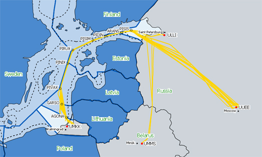
Russian planes have also been forced to make changes to their usual flight plans. In Flying to Kaliningrad during the Russian flight ban Spinielli has mapped out the flight paths that Russian planes have been having to make in order to fly to the Russian enclave of Kaliningrad. Since February 27 commercial flights between mainland Russia and Kaliningrad have had to follow the Baltic Sea avoiding Finland, Sweden and the other Baltic states.

In a third installment in his series visualizing the impact of the Ukrainian invasion on commercial airlines Spinielli has also mapped out evidence of GPS jamming around Kaliningrad.