Showing posts with label geology. Show all posts

Saturday, August 30, 2025

The New Geologic Map of the United States

The United States Geological Survey has released a new geologic map of the United States that lets you click anywhere in the country to see the rocks, sediments, and geologic units under your feet, along with their age and material type.

The Cooperative National Geological Map was created by combining around 100 state and regional maps into one seamless, nationwide view of U.S. geology. The map uses standard U.S. Geological Survey (USGS) colors and patterns, but you don’t need to know those standards in advance - when you zoom in on the map, a legend automatically appears. This legend automatically updates to explain the colors currently visible in your map view.

The map sidebar allows you to explore different geologic map layers:

  • Earth Surface - geology exposed at the surface.
  • Quaternary - deposits from the Quaternary Period (youngest geologic materials).
  • Pre-Quaternary - older rocks beneath surface deposits.
  • Precambrian - very old basement rocks.

This new national geologic map lets you explore both a simplified national view and the original state-level geology. Users can spot big geologic patterns across the country, then zoom in for detailed views from local maps. It offers instant access to America’s geologic story in a way that’s easy and engaging to explore.

Tuesday, January 05, 2021

The Interactive Geological of the World

William Smith is largely credited with creating the first nationwide geological map. Smith's beautiful 1815 map 'A Delineation of the Strata of England and Wales with Part of Scotland' visualized Britain's geological types using different colors for different types of geological feature. Smith's use of colors and many of his names for different strata are still used today.

You can see William Smith's enduring influence for yourself on the Macrostrat interactive map. Macrostrat is a global map visualizing the world's geology. Using the map you can explore stratigraphic and lithological data for any location on Earth. For example if I click on my location on the map I discover that I live on top of the Thames Group, which has a lithology of clay, silt, sand and gravel.


The British Geological Survey is also upholding the tradition of beautiful geological maps with its own Geology of Britain interactive map. This interactive map follows the same methodology used by Smith in the 19th Century. On the map different colors are used to show different types of bedrock geology. If you click on the map you can learn more about the bedrock geology and superficial deposits at the selected location. The information provided includes details on when and how the displayed type of geology was originally formed.


You can even view interactive versions of William Smith's Maps online. These interactive maps allow you to explore Smith's original geological maps of England, Scotland & Wales in very close detail. The interactive map interface allows you to view geo-rectified overlays of a number of William Smith's maps including his original 1815 geological map and his 1828 New Geological Map of England and Wales.

Monday, November 09, 2020

The Atlas of the Underworld

The Atlas of the Underworld is an interactive map with a difference. While most maps are designed to help you navigate above ground the Atlas of the Underworld enables you to discover what lies beneath your feet, in the Earth's mantle. 

The mantle makes up about 67% of our planet's mass. The Atlas of the Underworld maps the Earth’s upper and lower mantle, showing the location of all subducted slabs, organized by age, depth, and name.

The interactive Atlas of the Underworld includes a slide control which allows you to set the depth of the tomography slice of the mantle shown.The markers on the map show the location of the all slabs shown in the current map view. If you click on these markers you can view more information on the selected anomaly, view vertical and horizontal cross sections of the anomaly and view more information about the slab's location and depth. 

If you are interested in learning more about the world beneath your feet then you might also enjoy these Interactive Geological Maps.

Thursday, August 20, 2020

Interactive Geological Maps


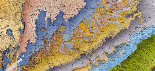
William Smith was the first geologist to create a nationwide geological map of the UK. A geologic map reveals the distribution of geological features such as different types of rocks. Smith's beautiful 1815 map visualized Britain's geological types using different colors for different types of geological feature.

The British Geological Survey is upholding the tradition of beautiful geological maps with its own Geology of Britain interactive map. This interactive map follows the same methodology used by Smith in the 19th Century. On the map different colors are used to show different types of bedrock geology. If you click on the map you can learn more about the bedrock geology and superficial deposits at the selected location. The information provided includes details on when and how the displayed type of geology was originally formed.


You can view interactive versions of William Smith's Maps online. These interactive maps allow you to explore Smith's original geological maps of England, Scotland & Wales in very close detail. The interactive map interface allows you to view geo-rectified overlays of a number of William Smith's maps including his original 1815 geological map and his 1828 New Geological Map of England and Wales.


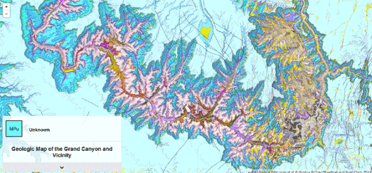
Digital geological maps can add a level of interactivity to the visualized geological strata. In other words online interactive maps can be used to reveal more information about the geology being mapped. A good example of this is the Geological Map of the Grand Canyon and Vicinity.

The Geologic Map of the Grand Canyon and Vicinity is a beautiful Leaflet.js based interactive map of the Grand Canyon. The map is based on data gathered by the U.S. Geological Survey. The map uses different colors to show the different rock units and geologic strata in the Grand Canyon and surrounding area. The map also includes contour lines. If you hover over the map the geologic strata at that location is revealed in the small information window. If you click on the map you can learn more about that geologic strata in the information dynamically loaded below the map.


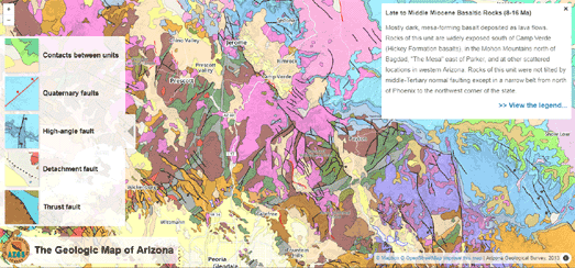
Another good example of an interactive geological map is the Geologic Map of Arizona. The Geologic Map of Arizona also includes interactive colored geological features. If you mouse over a feature on the map the geological information is revealed on top of the map. The Geologic Map of Arizona also visualizes the different types of geological faults which can be found in Arizona.


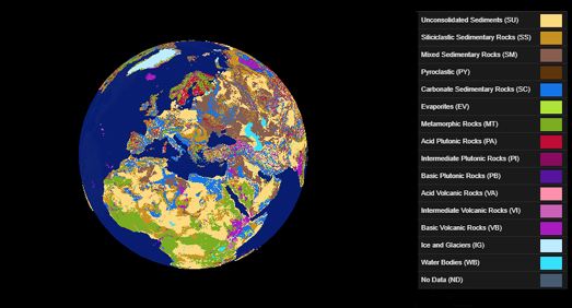
You can view a global interactive geological map on the Lithological Map Viewer. The Lithological Map Viewer is a 3D globe showing the types of rock which are present at the surface of the Earth across the whole planet.

Lithology is the classification of rocks based on their visible physical characteristics at outcrop. These classifications are normally based on the color, texture, grain size, and composition of the rock. Because lithology classifies rocks at outcrop it can play a key role in understanding processes occurring on the surface of the Earth, for example processes concerning soils, ecosystems, rivers, and oceans. The three main types of rock are sedimentary, igneous, metamorphic. The Lithological Map Viewer shows sixteen different classes of rock.

Monday, December 04, 2017

Macrostrat's Geologic Map of the World


The English geologist William Smith is credited with creating the first nationwide geological map. A geologic map reveals the distribution of geological features such as rock units or geologic strata. Smith's beautiful 1815 map visualized Britain's geological types using different colors for different types of geological feature (you can view interactive versions of William Smith's geological maps of England, Scotland & Wales at William Smith's Maps).

Macrostrat is a collaborative platform for geological data exploration and integration. They claim to have the world's largest geologic map database. Their interactive Geologic Map allows you to explore the geology of the whole world. If you click on the map you can view information on the age, lithology and geologic strata at your selected location. The Macrostrat Geologic Map also includes an option to view elevation profiles. If you select elevation profile from the map menu you can draw a line between any two points on the map to view an elevation chart beneath the map.

Monday, January 13, 2014

The Prettiest Map of the Week


This Geologic Map of the Grand Canyon wins the prize for the most gorgeous map of the week. The map uses the Leaflet mapping platform with USGS data to create an interactive geologic map of the Grand Canyon.

If you mouse-over the map the make-up of the geologic strata at that location is automatically displayed on the map. If you click on the map the map scrolls off the page to present a more detailed breakdown of the geographic strata at the selected location.