Showing posts with label religion. Show all posts

Tuesday, June 30, 2020

The Virtual Hajj


This year, because of the coronavirus outbreak, the Hajj pilgrimage has been limited to only one thousand pilgrims. For Muslims the sacred Hajj pilgrimage is an essential life journey, a trip which they must make (if they are capable) at least once in their lifetime.

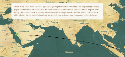
The Kontinentalist has created an interactive story map, Inside the Sacred Hajj Pilgrimage, which explains how people undertook the Hajj in the age before air travel. Before the age of flight pilgrims would often travel by kapal haji (ships). For many Muslims traveling from Southeast Asia Singapore was an essential hub for the journey to Mecca. Pilgrim brokers, boarding houses, and stores in Singapore all catered to the needs of the many pilgrims taking the Hajj.

The Kontinentalist article also maps out a step-by-step guide to the Hajj. Using another story map the article explains some of the rituals, journeys and prayers that pilgrims must make over the many days of the Hajj.

Nowadays of course many pilgrims undertake the journey to Saudi Arabia by plane. The Kontinenalist explains how the numbers taking the Hajj has surged since of the advent of air travel. In fact since 1988 Saudi Arabia has introduced a quota system to manage numbers, issuing one pilgrimage visa for every 1,000 Muslims in each country.


Despite the quota system millions of people still make the annual pilgrimage to Mecca by plane. In Flying to Hajj Al Jazeera visualizes and explores the 16,888 flights made to Mecca during last year's annual pilgrimage. The map shows the thousands of flights from all around the world which converge on Mecca during the  Hajj.

To reach Mecca many pilgrims fly to Jeddah,  the nearest airport, which is 80 km from Mecca. Alternatively pilgrims fly to Medina to visit the Prophet's mosque at al-Masjid an-Nabawi, before then completing the 450 km trip south to Mecca. Al Jazeera's Flying to Hajj map visualizes over 10 million individual GPS co-ordinates from all inbound flights to Jeddah and Medina over the Hajj period. On the map you can view the tracks of individual planes arriving from all around the world as they approach and land at Jeddah and Medina.

The country with the most flights to Jeddah and Medina last year during the Hajj was Egypt, with 1,618 flights. The UAE, Pakistan, Turkey and India, in that order, sent the next most flights to Mecca. The top three airlines (by number of flights) were Saudia, Turkish Airlines and EgyptAir.

Wednesday, December 18, 2019

Mapping the Exodus of Egypt


MosesTrek is an interactive map which plots the Biblical journey of Moses and the people of Israel from Egypt to Palestine. As you progress through the map you can follow the journey of the Israelites on their exodus of Egypt based on the account given in one of the oldest German-language Bibles from the 15th century. MosesTrek also uses information used in vintage 19th century maps and illustrations.

One of the two main vintage maps used as a basis for MosesTrek is the 1840 Map of the Promised Land (printed in Rostock around 1830), which is a map of "the 40-year journey of the children of Israel according to the scriptures". The other main historical map used is the Map of the Nile Delta to Palestine, (printed in London in 1848), which includes a plot of the "Israelite train from Egypt to Canaan".

Where the actual locations mentioned in the Bible aren't definitively known MosesTrek points to plausible locations. For example the real location of Mount Sinai (where God gave Moses the Ten Commandments) is not known so MosesTrek identifies locations which are plausible based on the Biblical story and timeline. MosesTrek also points to the locations which were identified as Mount Sinai in the German and English vintage historical maps of the Exodus.

MosesTrek is in German. However, the map works well with Chrome's 'translate this page' option. The map is also fairly easy to follow even if you have only a little familiarity with the story of Moses' journey.

Tuesday, November 05, 2019

Mapping the Epistles of Paul


You can now read and explore the world's oldest existing manuscript of the letters of St. Paul as an interactive map. The University of Michigan's Epistles of Paul presents the original manuscript of the letters of St.Paul as an interactive Leaflet map, shown side-by-side with a modern translation of the text.

If you click on the text icon in the map menu then all the lines in the original manuscript are made interactive. Now if you mouse-over a line on the manuscript the corresponding line is highlighted in the translation. The translated text also includes interactive footnotes. These footnotes mostly explore some of the differences in the historical manuscript from the standard text of the New Testament.

The thirty leaves of the manuscript held by the University of Michigan were written in about 200 C.E. and were found in Egypt in the 1930's. The Epistles are written in ancient Greek. The original manuscript was written without word division, punctuation, headings, or chapter and verse numbers. So even if your ancient Greek is very good you still might need the help of the modern translation.


The Epistles of Paul viewer was made using Jack Reed's Leaflet-IIIF, which is JavaScript library for viewing IIIF images with a Leaflet.js interactive map. IIIF is a format which is used by museums, newspapers and galleries around the world for presenting and sharing digitized images. A IIIF viewer is a tool for presenting artworks and digitized records in a form like an interactive map. A IIIF viewer essentially allows you to pan around and zoom in and out on a digitized image like you would on an interactive map.

Many museums and libraries around the world have created IIIF manifests for their collections of vintage maps. The Leaflet-IIIF Leaflet plug-in is therefore a fantastic resource for presenting and exploring vintage maps from many of the world's largest map collections. In the Epistles of Paul the plug-in has been used to present an interactive interface for reading an original historical manuscript. The plug-in can obviously be also used as an interface for exploring vintage maps which have been made available as IIIF manifests.


For example my Matthew Paris' Map of Britain uses the Leaflet-IIIF plug-in to present a short story-map of Matthew Paris' Map of Britain. Matthew Paris' Map of Britain is one of the first ever geographical maps of Britain. It was made by Matthew Paris, a 13th Century monk.

My story-map examines some of the geographical errors Matthew Paris' made in his map of Britain in order to better understand the geographical conception he had of Britain in the 13th Century. The map also includes modern English translations of medieval place-names. Just click on the place-names on the map to view the names we now use for these towns and cities.

My map uses the IIIF manifest of Corpus Christi College's manuscript of Matthew Paris' map. As well as using Jack Reed's Leaflet-IIIF plug-in the story-map element makes heavy use of waypoints.js to trigger the map actions when scrolling the page.

Sunday, November 03, 2019

The Orientation of London's Churches


Today's #30DayMapChallenge is to create a map containing polygons. My Church Orientations map displays London churches as extruded polygons. The compass rose on the map also visualizes the orientation of all the churches in the current map view.

Since the 8th Century churches have tended to be built facing towards the east. The main focus of a church, the alter, is placed at the east end of the church, often in an apse. The major entrance to the church is often placed at the west end. In fact the word 'orientation' actually comes from the practice of constructing buildings to face the east. Building a church the other way around, with the entrance at the east and the apse at the western end, is called 'occidentation'.

nine English cathedrals - mainly oriented to the east (looking at you Liverpool Cathedral)

When early Christians prayed they would face towards the east. Hence the tradition of building churches with the alter towards the east. One theory for why Christians pray towards the east is that the beginnings of the organized church was in Europe and worshipers were praying in the direction of Jerusalem. Another theory for why churches face east is because they have been aligned to where the sun rises on each church's saint day.

My Church Orientations map uses the building footprints (the lines which define the outline of the churches) for the orientation compass rose. In other words the compass rose shows the orientation of all the churches' walls (in the current map view). In general the map reveals that churches in London are roughly orientated eastwards, with a fair share orientated between east and north-east.

Tuesday, October 22, 2019

How Clearwater was Conquered by Aliens


Like an invading race of aliens from a bad science-fiction novel Scientologists have slowly and stealthily taken over the city of Clearwater, Florida. There are now very few non-infected humans left in the town. In 1975 the Scientologists bought one hotel in Clearwater. They then drew up plans to take-over the city. Over the years the church bought up properties in the surrounding blocks. The church now owns 185 properties in Clearwater. These properties cover 101 acres in the center of the city.

The Tampa Bay Times has created a story map which uses Google Earth satellite imagery to show the extent of Scientology's control of Clearwater properties. As you scroll through How Scientology Doubled its Downtown Clearwater Footprint in 3 Years individual buildings are lit-up on a darkened oblique aerial view of the city to show which buildings have been taken over by the church. The technique is a very effective way to visualize the extent that Scientology has taken control of large parts of downtown Clearwater.

The Tampa Bay story includes some shocking details about other tactics that the church has taken to take control of Clearwater, including framing the mayor and planting spies in the local newspaper, chamber of commerce and the state attorney's office. The take-over of such a large area of downtown Clearwater has also had a very adverse effect on local businesses.

Friday, September 27, 2019

16 Thousand Flights to Mecca


Every year millions of Muslims around the world fly to Mecca to perform the Hajj. The Hajj is the annual Islamic pilgrimage to Mecca. It is something that every Muslim must do at least once in their lifetime, if they are capable.

Flying to Hajj is an interactive story map by Al Jazeera which visualizes and explores the 16,888 flights made to Mecca during this annual pilgrimage to Mecca. The map shows the thousands of flights from all around the world which converge on Mecca during the  Hajj.

To reach Mecca pilgrims fly to Jeddah, the nearest airport which is 80 km from Mecca. Alternatively pilgrims fly to Medina to visit the Prophet's mosque at al-Masjid an-Nabawi, before then completing the 450 km trip south to Mecca. The Flying to Hajj map visualizes over 10 million individual GPS co-ordinates from all inbound flights to Jeddah and Medina over the Hajj period. On the map you can view the tracks of individual planes arriving from all around the world as they approach and land at Jeddah and Medina.

The country with the most flights to Jeddah and Medina during the Hajj was Egypt, with 1,618 flights. The UAE, Pakistan, Turkey and India, in that order, sent the next most flights to Mecca. The top three airlines (by number of flights) were Saudia, Turkish Airlines and EgyptAir. In order to avoid overcrowding the Saudi government actually allocates the number of visitors permitted from each country. This number is mostly determined by the number of Muslims in each country.

Tuesday, September 10, 2019

The Saints of Europe


I was so fascinated by Dirk Kloosterboer's fascinating investigation into the spatial distribution of roads named 'Holleweg' (or 'Holloway') around the world that I decided to try my own investigation into the spatial distribution of place-names. For my analysis I wanted to explore the density and distribution of towns and cities in Europe named for Christian saints.

As a work of data visualization my finished map should be taken with a piece of salt. Soon after starting my investigation I realized my lack of language skills was seriously going to impair my research into towns named for saints across Europe. However despite the fact that my map is next to useless I still think the process of making it is quite interesting.

If you want to view the finished map then you can find it here - The Saints Of Europe.

All the data from my map comes from OpenStreetMap. To get the data I used Overpass Turbo. I queried Overpass Turbo to find towns and cities which included the words 'St', 'Saint', 'San', 'Santo', 'Santa' and 'Sankt'. You can see how the query is formed in the example below:
[out:json][timeout:85];
// gather results
(
node[place=town] ["name"~"Santo "]({{bbox}});
node[place=city] ["name"~"Santa "]({{bbox}});
node[place=city] ["name"~"Santo "]({{bbox}});
node[place=town] ["name"~"Santa "]({{bbox}});
node[place=city] ["name"~"San "]({{bbox}});
node[place=town] ["name"~"San "]({{bbox}});
);
// print results
out body;
>;
out skel qt;

Rather than search for specified countries I restricted my search to rough bounding boxes around the UK, France, Spain, Germany and Italy. I wanted to restrict my search to these countries but I was also interested in capturing any towns and cities named for saints in areas closely bordering these countries as well. Therefore rather than querying these countries individually by name I used a bounding box for searching each country. These bounding boxes overlapped other countries to capture towns in other countries near the country border.

I carried out five separate searches in Overpass Turbo (one each for the UK, France, Spain, Germany and Italy. I downloaded the results of each search as a GeoJSON file. I then combined the five separate files into one GeoJSON file using geojson.io.

Once I had one GeoJSON file containing all the towns and cities named for saints I saved it as a tileset in Mapbox Studio. The data downloaded from Overpass Turbo also included the population of every town and city named for a saint. When you load a tileset into the Mapbox Studio style editor you can style how the data appears on the map. I decided to show each town as circles with the radius of the circles determined by the population size of the town or city. Therefore on my finished map the size of the circles represents the size of the population.

Although I wouldn't recommend my map as an effective data visualization I do find it interesting that the Protestant countries of Germany and the UK appear to have far fewer towns named for saints than the Catholic countries of Italy, France and Spain. Germany in particular seems to have very few towns named for saints.

Wednesday, July 10, 2019

Do Mosques Face East?

Last week I attempted to answer the question Do Cathedrals Face East?. Of course Christianity is not the only religion which expects its adherents to pray in a specific direction. In Islam the qibla is the direction that Muslims should face while praying. The qiblah is the direction facing towards the Kaaba in Mecca.

Above are the aerial images of six of England's most notable purpose-built mosques. All six mosques have a similar orientation and each has a wall facing in a south-easterly direction - in the direction of Mecca. The Fazl Mosque in London seems to deviate most from the orientation of the other mosques. This may be because it was London's first purpose-built mosque (1926).

Mosques around the world have a mihrab set into a wall which indicates the direction of Mecca. Mustafa Yilmaz in Historical mosque orientation in Turkey explores some of the historical methods used to determine qibla through the ages. These changing methodologies is one reason why mosques have slightly different orientations from each other, so that even mosques in the same towns might have mihrabs pointing in different directions.

Pantazis & Lambrou claim, in Investigating the orientation of eleven mosques in Greece, that the three most common methods of calculating the qibla direction are "Basic spherical trigonometrical formulae; Stellar observation; and Recording the solar shadow." Pantazis & Lambrou found that all the eleven Greek mosques that they investigated had a southeastern orientation with a usual deviation of between 6 and 10 degrees. They explain these deviations as being a result of the historical limitations in qibla calculations when the mosques were built.

Because a Mosque's mihrab is orientated towards Mecca mosques in the same country are therefore likely to be orientated in similar directions. However, because of historical changes in how this orientation is determined, there may still be some deviations in the orientations of mosques. It is also worth noting that it is far more important that the mihrab faces towards Mecca than for the actual Mosque building to be orientated towards the Kaaba.

Tuesday, July 02, 2019

Do Cathedrals Face East?

The image above shows the building outlines of nine of England's largest cathedrals. One of these cathedrals is different from the rest.

The building outline of Liverpool Cathedral is not very detailed in Mapbox Studio (which I used to create these building outlines). However the outline does reveal the north-south orientation of Liverpool Cathedral. This is obviously very different from the orientation of the other cathedrals shown here.

Since the 8th Century churches have tended to be built facing towards the east. The main focus of a church, the altar, is placed at the east end of the church, often in an apse. The main entrance to the church is often placed at the west end. The word 'orientation' actually originally came from the practice of constructing buildings to face the east. Building a church which has the entrance at the east and the apse at the western end is called 'occidentation'. All of the cathedrals shown above (apart from Liverpool) have been built (roughly) facing east, with the apse on most of them also to the east of the building.

When early Christians prayed they would face towards the east. Hence the tradition of building churches with the altar towards the east. One theory for why Christians pray towards the east is that the beginnings of the organized church was in Europe and worshipers were praying towards the direction of Jerusalem. Another theory for why churches face east is because they have been aligned to where the sun rises on each church's saint day.

In Churches Face East Don't They? Ian Hinton measured the orientation of 1,747 churches in England and Wales. He discovered that the mean orientation of all these churches was 86 degrees, so just four degrees off true east. Eight of the cathedrals in the image above are only a few degrees out from facing east. Liverpool Cathedral is a lot more than four degrees off facing east.

So why doesn't Liverpool Cathedral face east? One clue might be the cathedral's age. Liverpool Cathedral is by far the youngest cathedral shown, having been built in the 20th century. According to Wikipedia, the "importance attached to orientation of churches declined after the 15th century." I wanted to see how true this is so I decided to look at the footprints of six of the first large cathedrals built after the start of 1500.


In this image 15 cathedrals are shown in chronological order. The cathedrals in the top row were all constructed before the end of the 13th Century. The construction of the cathedrals on the second row were all started after 1573. I think it is clear that the cathedrals in the second row, on average deviate more from true east than the cathedrals in the top row.

St. John's Cathedral in Canada (second to last cathedral shown) is actually an occidentation cathedral, with the apse at the western end of the cathedral. St. John's was built from 1839-55. Wikipedia says that the cathedral "is not oriented on an east-west axis, ... but rather, it was constructed on an orientation with its facade facing the line of the rising sun on the Winter Solstice, and the setting sun at the Summer Solstice". As we have already seen the youngest cathedral on the map, Liverpool Cathedral, has a north-south orientation.

Monday, July 01, 2019

Jewish London


We Were There Too has created an interactive version of the Jewish East London map. This map was commissioned by the Toynbee Trust in 1899, to visualize where the Jewish community lived in East London.

The Jewish East London map was made by George Arkell, a statistician and social geographer, who had worked on Charles Booth's survey of London poverty. The English philanthropist Charles Booth had systematically plotted the levels of poverty and wealth in every street in London in the last two decades of the 19th century. Booth published the results of his research in 'Life and Labour of the People in London'. You can explore Booth's maps for yourself on the LSE's Charles Booth's London website.

Booth's publication included detailed 'Maps Descriptive of London Poverty' in which the levels of poverty and wealth in London were mapped out street by street. On Booth's maps the buildings in each street were colored to indicate the occupants' social class.

Geroge Arkell's Jewish East London map uses exactly the same visualization technique as Charles Booth's maps of London poverty. Individual streets are colored on the map to show the proportion of each street's occupants who are Jewish. The legend is cut off from the We Were There interactive map, this legend includes an indication of what the individual colors mean (We Were There have reproduced this under the map) and a note to the effect that "In all streets coloured blue the Jews form a majority of the inhabitants; in those coloured red, the Gentiles predominate."

You can view a version of the Jewish East London map, with the legend still present, at the Cornell University Digital Collections. Cornell attach a lot of significance to the fact that the Jewish East London map uses the same dark blue color as used in the Charles Booth maps "to represent 'vicious, semi criminal' areas". However this isn't true. Black was used on the Booth maps to indicate 'vicious, semi-criminal' streets. Dark blue was used to represent 'very poor, casual, chronic want'.


The Jewish East London map reveals that the Jewish population in East London was most concentrated in Whitechapel and Spitalfields. In the later half of the Nineteenth Century the Jewish population in England had nearly doubled as a result of large scale immigration from Eastern Europe. For much of the Twentieth Century this area of East London had a large Jewish population. However over the course of the Twentieth Century the Jewish population drifted away from the East End.

The latest UK census data reveals that the percentage who are Jewish in these areas is now below 1% of the total population. This UK Census Explorer map shows the percentage of the Jewish population in each London ward. It reveals that areas of north London, such as Golders Green and Edgware, now have the largest Jewish populations.

Monday, June 17, 2019

Which Europeans Believe in God?


The Romanians are the most religious people in Europe. 55% of Romanians say that they are 'highly religious'. Estonia is Europe's least religious country. Only 7% of the Estonian population say that they are 'highly religious'. Despite being the most 'highly religious' people in Europe Romanians aren't Europe's biggest believers in God. That privilege belongs to Armenia, where 79% of the people say they believe in a Supreme Being. In comparison only 64% of Romanians believe in God.

According to the Pew Research Center Europeans are generally less religious than people in the rest of the world. However the religious commitment of Europeans varies greatly from country to country. The Pew Research Center has therefore decided to map out the religiosity of European countries.

The interactive map in How Do European Countries Differ in Religious Commitment? shows the percentage of people in each European country who self-identify as 'highly religious'. The Pew Research Center surveyed Europeans on five different questions about their religious belief and practice. The map only shows the results for Europeans' overall religiosity (the percentage of the population who say they are 'highly religious'). However you can view the results from the other four questions about religion in a series of tables. These tables order European countries, from most religious to least, giving the percentage of people who identified as religious in each of the separate questions.

Friday, January 04, 2019

The Geography of the World's Religions


Recently Pew Research released an interactive map called How Religious is Your Country?. This map visualized how many people in each European country identify as being religious. If you were wondering which religions those European believers follow you can find out with the World Religions Map.

The World Religions Map shows the most practiced religion in each country of the world. On this interactive map countries are colored to show the largest religious group. If you select a country on the map you can view the percentage of the population which follows the major religion and the percentages which follow all the other main world religions.

The World Religions Map also allows you to view the global distribution of the all the main religions. Select a religion from the map's drop-down menu and you can view a choropleth map showing the level of the religion's believers around the globe.

Friday, December 14, 2018

Exploring the Life of Maimonides


Moses ben Maimon, commonly known as Maimonides, was a medieval Jewish philosopher. He is revered as one of the most influential Torah scholars of the Middle Ages. The Israel Museum and the National Library of Israel is holding a joint exhibition on the life and works of Maimonides. It has also created an interactive map which allows you to discover more about some of the unique items being displayed in the exhibition.

In There was None Like Moses you can select individual artifacts on the map to learn more about their history and their role in the Maimonides exhibition. The map shrinks the globe down to a size that reflects the world known to Maimonides in the 12th century. The map is therefore not entirely geographically accurate.

The four cartouches in the map corners allow you to learn more about Maimonides and his work. The cartouche in the bottom left corner of the map provides a link to the Ktiv - The International Collection of Digitized Hebrew Manuscripts website of the Israel National Library, where you can view the digitized transcripts of Maimonides' works and manuscripts.

Monday, December 10, 2018

How Religious is Europe?


Romania has the most religious population in Europe. 55% of Romanians are 'highly religious' according to a recent Pew Research Center survey. The least religious population in Europe lives in Estonia, where only 7% are highly religious.

In How Religious is Your Country? Pew Research discovered that in general Central and Eastern Europeans are more religious than Western Europeans. In Central Europe the southern mainly Roman Catholic countries of Italy, Spain and Portugal are more religious than most other Central European countries. Although Ireland, another mainly Roman Catholic country, also scores highly when compared to other Central European countries.

The Pew assessment of its religious survey of European countries is accompanied by a choropleth map which shows the level of religious belief in 34 European countries. You can mouse-over individual countries on the map to see what percentage of the country's population are highly religious. In its survey Pew looked at four measures of religious observance. These were: attending religious services at least monthly, praying at least daily, believing in God with absolute certainty and saying that religion is very important to them. Those people who scored highly on at least two of these measures have been deemed to be 'highly religious'.

Friday, September 14, 2018

The Interactive Map of Jewish Places


Jewish Places is a new interactive map designed to provide detailed information about locations which have been important to Jewish life in Germany. The new Jewish Places website aims to provide a tool which can help individuals document and explore Jewish life in Germany and provide a guide to local Jewish history in towns and cities across the country.

The Jewish Places interactive map provides a resource for showing both religious and secular locations. It can be used to document and find the locations of synagogues, prayer houses, cemeteries or mikwaot. It can also be used to find the locations of secular facilities such as sports clubs, Jewish salons or cafes. The map can also be used to document and locate locations which where important in the lives of Jewish Germans. So, for example, it can be used to create a biographical walking tour for an important historical individual.

Anyone can contribute to the Jewish Places website. The site encourages people to contribute their knowledge of local places important to Jewish life. When adding a place to the map you can upload or input text, images or videos to help document the history of your submitted location.


As a crowd-sourced map Jewish Places will hopefully develop lots of content over time. For now, if you are interested in Jewish history you will probably find more information on Jewish Cultures Mapped. Jewish Cultures Mapped is an interactive timeline and map exploring Jewish cultures around the world within their historical context. The map allows you to explore the history of Jewish culture throughout history and across the globe.

Jewish Cultures Mapped provides three main ways to navigate your way through the history of Jewish culture. The map allows you to explore this history by location. Zoom in on a city and you can explore all the cultural stories associated with the city by clicking on any of the map markers. The markers are colored by date (you can use the timeline to determine the date of each color).

You can also explore the history of Jewish Cultures using the timeline running along the bottom of the map. This interactive timeline allows you to navigate to different periods in Jewish history to explore the history of Jewish culture at that time.

Jewish Culture Mapped also allows you to explore Jewish cultures by category. The history of Jewish cultures has been ordered into a number of different categories, including Projects, People, Place and Organizations. This allows you to explore the history of Jewish Cultures by theme, individuals and organisations, companies & groups.

Thursday, February 22, 2018

Finding Qibla


As someone who works with location data and digital maps I really should love Augmented Reality. However, despite being initially excited by a few AR projects, I don't think there is one AR project that I've ever visited more than once. Perhaps if I were Muslim Google's Qiblar Finder would be the AR application to finally earn a permanent bookmark on my phone.

Qibla is the direction of Mecca. The direction that should be faced during salah prayers. The Qibla Finder allows you to find the direction of Qibla from wherever you are in the world. The website uses Google Maps Street View and GPS to provide an augmented reality view of Qibla. Visit the Qibla Finder on your phone and you can view a Street View image of your current location with a map marker and line indicating the direction that you should pray.

If you visit the Qibla Finder from a desktop then you can view a Google Map of your direction with a line leading from your location towards Mecca.

Monday, February 12, 2018

Mapping the History of Jewish Cultures


Jewish Cultures Mapped is an interactive timeline and map exploring Jewish cultures around the world within their historical context. The map allows you to explore the history of Jewish culture throughout history and across the globe.

Jewish Cultures Mapped provides three main ways to navigate your way through the history of Jewish culture. The map allows you to explore this history by location. Zoom in on a city and you can explore all the cultural stories associated with the city by clicking on any of the map markers. The markers are colored by date (you can use the timeline to determine the date of each color).

You can also explore the history of Jewish Cultures using the timeline running along the bottom of the map. This interactive timeline allows you to navigate to different periods in Jewish history to explore the history of Jewish culture at that time.

Jewish Culture Mapped also allows you to explore Jewish cultures by category. The history of Jewish cultures has been ordered into a number of different categories, including Projects, People, Place and Organizations. This allows you to explore the history of Jewish Cultures by theme, individuals and organisations, companies & groups.

Tuesday, October 31, 2017

500 Years of Protestantism


500 years ago today a little known monk called Martin Luther nailed his Ninety-five Theses to a chapel door in Wittenberg. It was an act that would lead to the Reformation and that would change the world forever. Here I Stand is a website exploring the life and work of Martin Luther, the birth of the Reformation and its lasting effect on the world.

Here I Stand includes a number of interactive and static maps which are used to explore the spread of the Reformation and to explain the world in which Martin Luther lived. These maps include a 3d map of Sixteenth Century Wittenberg, where Martin Luther lived and worked. Although a static map it does include labels (turn them on using the 'discover more' button) which show important locations in the town.


Here I Stand also features a number of interactive maps. These include a map of the Holy Roman Empire showing locations with a Martin Luther connection. Another interactive map shows how the reformation quickly spread through towns and cities in the Holy Roman Empire during the first half of the Sixteenth Century. The Reformation Movement map includes buttons which allow you to filter the cities shown by the date that they introduced the reformation.

If you like the maps featured on Here I Stand you can print them out as PDF map posters.


The Newberry Library in Chicago is currently holding a major exhibition on Religious Change and Print, 1450-1700. In support of this exhibition they have put together an online collection of the Newberry Library's manuscripts, maps and images from the Reformation.

One online contribution to the exhibition is an interactive story map Tracking the Lutheran Controversy. The map explores the role of printing in spreading the ideas of an obscure monk in Wittenburg to the whole of Europe.

Tracking the Lutheran Controversy examines some of the key pamphlets and texts published by Martin Luther (and the papal bulls issued in response). As you progress through Tracking the Lutheran Controversy the map shows how Luther's ideas spread throughout Europe. It also looks at the publication of responses to Luther, both in support and against his beliefs.


The Newberry Library online collection also includes a superb interactive presentation of Giovanni Merlo’s engraved map of Venice from 1676. This interactive version of Merlo's Map includes information about the engraving and some of the Venetian locations depicted in the map. The colored circles on the map pick out some of Reformation Venice's most important churches, monasteries and printing centers. You can click on these circles to learn more about each highlighted location and view other illustrations of the location from the Newberry collection.

If you select the 'toggle maps' button (from the navigation buttons running down the center of the interactive) you can directly compare Merlo's Map side-by-side with other vintage maps of Venice. These other maps include Jacopo de Barbari 1500 map of Venice, Benedetto Bordon's map of 1534 and Paolo Forlani's Venetia from 1566.

Wednesday, September 07, 2016

Mapping the 2015 Hajj Crush


During last year's Hajj hundreds of pilgrims were crushed to death in Mecca. The Hajj is the largest annual gathering of people in the world. The large increase in pilgrim numbers over the last two decades has resulted in a number of tragic accidents and crushes which have resulted from the overcrowding.

The New York Times has published an interactive account of last year's tragic events, told from the perspective of Rashid Siddiqui, a survivor of the crush that led to so many deaths. This account includes a story map which visualizes the route of Rashid's pilgrimage, the location of his tent, the route he took to the Kaaba and the site of the crush.

As you scroll through the Times' How One of the Deadliest Hajj Accidents Unfolded the map zooms in and pans to highlight various locations in Rashid's journey. The map itself consists of an aerial view of Mecca, overlaid with place labels and colored polygons showing where pilgrims from different parts of the world camp. The map attempts to explain some of the events on the ground which led to the tragic crush, near the intersection of Street 204 and Street 223, which caused so many deaths.

Monday, June 27, 2016

Japanese Pilgrimage Mandalas


Gunma GIS Geek has used the Leaflet mapping platform to create interactive maps from a couple of famous Japanese pilgrimage mandalas. Pilgrimage mandalas are paintings which provide a panoramic view of temple and shrine sites.

The first map on Temple Pilgrimage Mandala is of the Nachi Pilgrimage Mandala. This 16th–17th century hanging scroll depicts the Nachi Shrine on the Kii Peninsula in Japan. The painting presents the journey of two pilgrims (the couple clothed in white) as they enter the scene (bottom right) and take a circuitous route through the temple complex to the Nachi shrine.


You can learn more about some of the over 50 buildings depicted in the painting on the Embodying Compassion website. Embodying Compassion includes an interactive version of the Nachi Pilgrimage Mandala. This interactive version of the mandala features a number of markers which allow you to learn more about the buildings, temples and statues depicted in the mandala.

You can view more examples of paintings which have been made interactive using mapping libraries in Putting the Art into Cartography.