Showing posts with label Custom Street View. Show all posts

Saturday, June 07, 2025

Is this the future of Street View?

Odyssey has released a demo of its new AI technology that enables users to explore 3D video environments in real time.

Odyssey is similar to Google Maps Street View in that it allows users to visually explore real-world environments. However, instead of navigating through static 360-degree photos, Odyssey uses AI-generated streaming video that responds dynamically to user input.

The result is a much more interactive and immersive 3D world - like stepping into a living, evolving version of Street View, where the environment can change and unfold as you move, almost like a video game. Unlike Street View, which relies on stitched-together images, Odyssey’s model generates new video frames on the fly, simulating realistic motion and spatial consistency in response to user movements.

The Odyssey Interactive Video demo includes a number of 360-degree scenes that you can freely explore. Most reviews I've read emphasize its potential for creating 3D worlds for games. However, I think there’s also clear potential for this technology to enhance mapping, for example as an advanced Street View layer. Currently, the interactive 3D environments produced by Odyssey are fairly low in resolution, though generally clear. It would be interesting to see whether the technology could generate higher-resolution models if it were trained on Google Street View imagery.

Via: Webcurios

Saturday, April 26, 2025

19th Century Street View of Chicago

Imagine stepping straight into the heart of history - and finding yourself surrounded by the wonders of 1893. The Chicago 00 Project makes it possible, weaving authentic vintage photographs of the 1893 World's Columbian Exposition in Chicago into a breathtaking, time-traveling Street View adventure!

For example, click on the White City Court of Honor map marker, and you are transported into the historical Street View scene above. Before you stretches the Grand Basin, upon which a gondolier in traditional dress floats gracefully by. Across the water, you can see the soaring golden dome of the Administration Building. To one side, the intricate colonnades of the Manufactures and Liberal Arts Building extend in stately rhythm, while on the other, the elegant Agricultural Building showcases its own classical grandeur.

Elsewhere on the map, you can find a bird’s-eye panoramic Street View of the entire Exposition grounds. Zoom in on the Midway Plaisance, and you can step into a whole series of vintage Street View scenes captured along the exposition’s central thoroughfare - including some breathtaking imagery taken from the towering Ferris Wheel.

Thursday, March 14, 2024

Flip Off the World with Street View

The UK Houses of Parliament being flipped off on Street View

AI and Street View seems like the perfect match. Last month panoramai released a fun tool which allowed users to change the appearance of Google Maps Street View images based on their own AI prompts. The app became so popular it had to be turned off because of the costs being incurred by the developers (you can still browse the example images created with the app).

Now a new Ai and Street View project has been released. Only this time the Ai doesn't stand for 'artificial intelligence', but is actually the first name of the famous Chinese artist Ai Weiwei. Because Ai Weiwei has collaborated with Avant Arte to release an interactive mapping tool which allows you to create an image of any location in the world being flipped off on Street View.

Since 2017 the artist Ai Weiwei has taken self-portraits of his own hand giving the middle finger to various iconic landmarks and institutions around the world. The result is "Study of Perspective", a powerful photographic series of Ai Weiwei flipping off some of the world's most iconic global centers of power and cultural importance.

Now thanks to Middle Finger you can join in the fun. Using the Middle Finger interactive map you can navigate to anywhere in the world (that has Street View imagery) and create your own image of a location being flipped off. After you have created your custom Street View image you can then download the image or share it on social media.

Monday, February 26, 2024

Street View Surveillance

A street in San Francisco with CCTV, licence plate readers and other surveillance equipment on view

The Electronic Frontier Foundation's Spot the Surveillance game is a virtual reality game which requires players to identify surveillance equipment in a panoramic image of a San Francisco street scene. Panning around this 360 degree view players are required to detect the every day surveillance equipment which is now routinely used on America's streets, such as body-worn cameras, automated license plate readers, drones, and pan-tilt-zoom cameras.

Spot the Surveillance is best played with a virtual reality headset but can be played using a standard computer browser as well. In the standard browser version of the game you simply need to click on any surveillance tech that you can spot and an information window will open confirming your guess and explaining how that tech is used.

a US Border Patrol aerostat ballon on Google Street View

I believe that Spot the Surveillance was originally released in 2020 but I only discovered it today via The Markup's report on A Virtual Reality Tour of Surveillance Tech at the Border. In this article Dave Maass of the Electronic Frontier Foundation takes Monique O. Madan of The Markup on a virtual reality tour of the U.S.–Mexico border. 

The article includes a list of links to Google Maps Street View panoramas from a number of locations along the border, all of which contain examples of US Border Patrol surveillance technology in action.

a side-by-side comparison of London and Los Angeles maps, showing the density of CCTV cameras in each city

Of course the U.S. isn't the only country in the world where surveillance technology has become ubiquitous. Surfshank's Surveillance Cities examines the density of surveillance cameras in cities around the world. By calculating the number of CCTV cameras per km2 in the world's 130 most populous cities Surveillance Cities is able to make direct comparisons between different global cities. 

The article includes an interesting mapped visualization which allows you to directly compare the density of CCTV cameras in any two of the 130 cities surveyed by Surfshark. For example the screenshot above shows a comparison of the density of surveillance cameras in Los Angeles and London.

Monday, November 20, 2023

Alternatives to Google Maps Street View

Panoramax is an open-source photo-mapping platform that allows users to share and exploit street level photography. It is a free alternative to proprietary services, such as Google Maps Street View, providing a freely available resource for sharing and mapping field photos. The Panoramax platform allows anyone to capture street level photographs and contribute them to the Panoramax database and interactive map. This imagery is then freely accessible and reusable by all.

Panoramax claims that "All photos (are) easily accessible and reusable without an account: via the website or a standard API (STAC format)". If you click on the 'share' button on the map you can also embed a Panoramax map and street level imagery on a website as an iframe.


Mapillary is another crowd-sourced platform for sharing and exploring street-level imagery. The platform allows users to upload and share images of streets, roads, and other public spaces from around the world. These images are then stitched together to create a continuous street-level view of the world. Mapillary is similar to Google Street View, but it used crowd-sourced images and anyone can contribute to it.

Mapillary was acquired by Meta in 2020 but was founded in 2013. Due to its ten year head start on Panoramax, Mapillary currently has far more imagery available on its platform. I'm guessing, however, that Mapillary's ownership by Facebook may be a disincentive to some users, who may be disinclined to share their street level imagery with Meta. To those users Panoramax may prove to be a welcome new addition to the world of crowd-sourced Street View.

KartaView (previously known as OpenStreetCam) is another platform which can be used for collecting, viewing and sharing street level imagery around the world. Thousands of people around the world currently use KartaView to map street level photographs using the KartaView apps for Android and iOS.

You can explore all the uploaded street level imagery on the KartaView interactive map. Where imagery is available roads are colored blue on the map. You just need to click on a blue road to view the available imagery for that location. KartaView's street level imagery is free to use under an open-source license.

Thursday, November 09, 2023

Documenting Russian Crimes in Ukraine

In March 2022 Russian troops invaded the Ukrainian village of Yahidne. During their month long occupation of the village the Russian army locked the villagers in a school basement. 360 people, including children and the elderly, where forced to live together in cramped and unsanitary conditions. There was so little space that people had to sleep standing up, people had to use buckets for toilets and there was very little food. During their imprisonment 11 of the villagers died. 

It is impossible to imagine the conditions in which the 360 residents of Yahidne were forced to endure by the Russian army. However thanks to the power of phtoogrammetry you can explore a 3D model of the school basement where the villagers were imprisoned. Hidenori Watanave's Satellite Images of Ukraine uses a 3D model to provide a virtual guided tour of the school basement. 

The photogrammetry 3D scan of the basement was captured by Kyiv-based @YaroPro4. This photogrammetry model was then added to a Cesium 3D globe by professor Hidenori Watanave of the University of Tokyo.

You can read more about the criminal actions of the Russian army in Yahidne and the awful conditions in which the villagers were kept on Time's article A Ukrainian Village's Month in Captivity in a Basement.

Australia's ABC News has published a number of 3D photogrammetry models to document the destruction caused by Russian missiles to culturally important Ukrainian buildings. The article Culture in the Crosshairs includes three separate visualizations which reveal the devastating destruction being caused to important Ukrainian landmarks.

The 3D models of Kharkiv’s historic red brick fire station, the Irpin Bridge and Chernihiv's historic regional youth library were each created using LIDAR data captured on the ground in Ukraine. This data was then processed into 3D photogrammetry models. Models which ABC News are then able to use to create interactive fly-throughs documenting and highlighting the scale of destruction of each of these historic landmarks.

360war is also working to document the damage being caused to Ukraine by Russia's illegal war and to ensure that this senseless destruction is seen by people around the world.

360war is documenting the destruction of Ukrainian towns and villages, showing the aftermath of Russian air strikes and artillery fire on the infrastructure and buildings of Ukraine. Using panoramic 'Street View' imagery 360war allows you to explore in close detail some of the devastating destruction left behind by the Russian army.

An interactive map shows the location of all the available 'Street View' images (mainly concentrated in Kharkiv, Kyiv and Chernihiv). On this map aerial panoramic images are indicated using a drone shaped marker, while ground based panoramic images are shown with black dots. Many of the interactive panoramas include a 'learn more' link which provide more information on the location depicted and the damage caused by the invading Russian army.

The Department of Tourism of the Kyiv Oblast State Administration is also determined to record and document the destruction being caused in their region. In order that no-one is ever able to forgot the crimes committed in the Kyiv region they have established a Virtual Museum of War Memory.

The main exhibit in the Virtual Museum of War Memory is a number of custom made Street View panoramas. These 360 degree panoramic images, taken at different locations in the Kyiv Oblast, allow you to take a virtual walk through some of the horrific destruction inflicted by the invading forces.

The Street View images for each of these virtual tours have also been added to Google Maps. This means that while exploring one of the museum's virtual tours you can click on the 'View on Google Maps' link to reveal the exact location on Google Maps. The 'i' information icon in the top right hand corner of the Street View image also reveals the name of the town where the panorama was taken.

You can view more of the terrible destruction inflicted by the invading Russian army on Hidenori Watanave's  3D Data & 360 Panoramas Map of Ukraine.

These maps use data from images and videos captured in Ukraine to recreate incredible 3D models of some of the devastation caused by the Russian army. 3D photogrammetric models have been created of buildings and vehicles which have been destroyed during the war using drone captured imagery and photos taken on the ground. The result is a shocking interactive 3D map which allows you to view some of the devastating destruction in Ukraine from an almost first person perspective.

Tuesday, May 16, 2023

AI Street View

Today I have mainly been creating AI generated Street View scenes of historical locations. The result is AI Time Travel Street View, a little virtual world of 360 degree panoramas which you can wander around in while exploring Medieval France, Renaissance Venice and Victorian London (as dreamed by AI).

Navigating around AI Time Travel Street View is fairly intuitive. Just click on the arrow links in the images to wander around. If you wish to travel through time and space to a new era you just need to clcik on one of the buttons in the top-left corner of a panorama.

If you want to create your own AI 'Street View' panoramas then you can use Skybox AI. Just enter a prompt description of the scene you require and Skybox AI will generate a 360 degree panorama based on your prompt.

If you want to create your own virtual world you can use Panolens to link together a number of different panoramas (created by Skybox AI or any other panoramic software). You can cheat a little by just cloning the Glitch of my AI Time Travel Street View. Play around with this Glitch and you should be able to work out how to add your own panoramic images and how to create the links between two different panoramas.

Hat-trip to Map Channels, whose panoramas of Victorian London inspired me to create this Street View tour of imagined historical locations. 

Wednesday, March 01, 2023

The Undeniable Truth on Street View

To mark the one year anniversary of Russia's illegal war on Ukraine the website 'Undeniable Street View' has been launched. By providing virtual walks through six Ukrainian cities with custom made 360 degree panoramic 'Street View' imagery the Undeniable Street View allows you to see for yourself the damage that Russia has inflicted on Ukrainian infrastructure. 

The cities of Kyiv, Irpin, Kharkiv, Izyum, Chernihiv and Sumy, like hundreds of other towns in Ukraine, have suffered incredible damage at the hands of Russian aggression. Using the custom panoramas in Undeniable Street View you can take a virtual walk around areas of these six cities to witness how Russia has targeted civilian infrastructure in its illegal war. 

Undeniable Street View has been created using drone and Street View imagery captured by War Up Close, led by Mykola Omelchenko. war Up Close has made it their mission to record the destruction caused by Russian forces in Ukraine. You can see more of their panoramic imagery and 360 degree models of Ukraine on their website War Up Close.

Also See:

Culture in the Crosshairs - 3D photogrammetry models documenting the destruction of culturally important Ukrainian buildings
360 War - more panoramic 'Street View' imagery from Ukraine
3D Models of Ukraine - Hidenori Watanave's photogrammetry models of destroyed buildings & vehicles
The Virtual Museum of War Memory - custom made Street View panoramas captured at different locations in the Kyiv Oblast.

Wednesday, May 18, 2022

Street View of War

The official website of the Department of Tourism of the Kyiv Oblast State Administration are determined to record and document the destruction being caused in their region. In order that no-one is ever able to forgot the crimes committed in the Kyiv region they have established a Virtual Museum of War Memory

The main exhibit in the Virtual Museum of War is a number of custom made Street View panoramas. These 360 degree panoramic images, taken at different locations in the Kyiv Oblast, allow you to take a virtual walk through some of the horrific destruction inflicted by the invading forces. 

The Street View images for each of these virtual tours have also been added to Google Maps. This means that while exploring one of the museum's virtual tours you can click on the 'View on Google Maps' link to reveal the exact location on Google Maps. The 'i' information icon in the top right hand corner of the Street View image also reveals the name of the town where the panorama was taken. 

You can also explore some of the terrible destruction inflicted by the invading Russian army on the incredible 3D models created by Hidenori Watanave on his Satellite Images of Ukraine and 3D Data & 360 Panoramas Map of Ukraine.

These maps use data from images and videos captured in Ukraine to recreate incredible 3D models of some of the devastation caused by the Russian army. 3D photogrammetric models have been created of buildings and vehicles which have been destroyed during the war using drone captured imagery and photos taken on the ground. The result is two shocking interactive 3D maps which allow you to view some of the devastating destruction in Ukraine from an almost first person perspective.

Saturday, November 27, 2021

Sea View


Put on your virtual life-jacket. This weekend we are going kayaking around Puget Sound, exploring the marine waterways and basins of this Pacific Ocean inlet. There is no need to worry about the cold weather either, because you can now explore this beautiful stretch of water through the power of interactive panoramic Sea View.

The Puget Sound Nearshore Mapping Campaign has been busy capturing 360 degree panoramic imagery of the Puget Sound nearshore by kayaking around the 1,200 miles of this north-western inlet of the Pacific Ocean. Using EarthView's new interactive map you can explore Sea View imagery of the Seattle waterfront, the Port of Tacoma, Fish Trap Cove and many other locations from around the sound. 

The beautiful panoramic imagery provided by EarthView is only one result of the Puget Sound Nearshore Mapping Campaign. EarthView is actually mapping Puget Sound by kayak in order to create more accurate maps of the sound nearshore. Maps which they hope can then play an important role in helping to recover and protect the critically important natural habitats of Puget Sound.

The kayak being used to capture this panoramic imagery of Puget Sound is also equipped with a water quality meter that has been used to record water conditions along the nearshore. The kayak has also been used to record animal sightings on the Puget Sound nearshore.

If you are feeling particularly adventurous then you might also consider taking a virtual dive beneath the waves. The Catlin Seaview Survey has been capturing underwater 360 degree panoramic imagery from across the world for a number of years. Their Virtual Dives website allows you to explore some of this submarine Street View imagery from the coast of Indonesia, among the coral reefs of American Samoa, from the Great Barrier Reef, the Galapagos and from many other beautiful undersea locations from around the globe.

Tuesday, August 03, 2021

Zelda's Hyrule Street View

The Legend of Zelda takes places predominantly in the land of Hyrule. There are many well-known landmarks in the Kingdom Hyrule, including, Hyrule Castle, the Lost Woods, Kakariko Village, Death Mountain and Lake Hylia.

For over 35 years video game players have been exploring the world of Link and Princess Zelda in Nintendo's Legend of Zelda franchise. They can now also explore Hyrule using Zelda Breath of The Wild Street View. Zelda Breath of the Wild Street View consists of a very basic image map of Hyrule, on which a number of map markers have been place. Click on one of these markers and you can view a 360 degree panoramic Street View image of the Hyrule game-world at that location. 

These panoramic Street Views allow you to explore various locations across the kingdom, including the Gerudo Ruins, the Satori Mountains, Lurelin Village and Zora's Domain. Many of these Street View images include navigational arrows which allow you to quickly walk between the connected Street View scenes.


Street View type panoramic images are a great way to bring fictional fantasy world to life. For example the panoramic Street Views in the Big City Map can transport you into the comic book world of the 'Brotherman: Dictator of Discipline' series. Big City Map is a project by Emory University’s Center for Digital Scholarship to digitally recreate the city depicted in the Brotherman comics. This digital creation includes a map of the city and three interactive Street View scenes of locations in Big City.


You can also explore a Street View scene from Paolo Bacigalupi's The Windup Girl. Julien Gauthier has created a wonderful interactive panoramic biopunk painting called BANGKOKXXIII - 360 Street. This 360 degree panoramic painting depicts a scene inspired by Paolo Bacigalupi's The Windup Girl. As you rotate around this panoramic image an imagined Asian street scene looms over your point of view, with towering skyscrapers, an overgrown overpass and even a gigantic elephant.

Tuesday, March 16, 2021

Open Street View

KartaView (previously known as OpenStreetCam) is a platform for collecting, viewing and sharing street level imagery around the world. People around the world use KartaView to map street level photographs using the KartaView apps for Android and iOS.

You can explore all the uploaded street level imagery on the KartaView interactive map. Where imagery is available roads are colored blue on the map. You just need to click on a blue road to view the available imagery for that location. KartaView's street level imagery is free to use under an opensource license.

Mapillary is probably the best known platform for capturing and sharing street level geo-tagged photographs. So far Mapillary and its users have collected 1,467,880,551 images around the world. 

The Mapillary interactive map colors roads green to show where street level imagery is available. Click on a green line and you can explore the available street level imagery. Using Mapillary's imagery in your own projects seems to have become a little more complicated since it was taken over by Facebook. I believe you can use the imagery for free in a non-commercial project but have to pay to use the imagery in a commercial product. You can find out more about the terms of use and how to access the imagery at Mapillary Developer Tools

Wednesday, February 24, 2021

Street Fashion on Street View

European fashion retailer Zalando has launched a new and unique online shopping experience. With its new Street It All campaign Zalando allows customers to view and buy street fashions directly from a Google Map.

Using the Street It All interactive Google Map you can explore custom street views shot in four different Spanish cities. Click on the map markers in Barcelona, Madrid, Malaga and Valencia and you can view custom shot 360 degree panoramic images captured by Zalando. In these custom Street View scenes you will find models wearing Zalando's street fashions. 

If you like any of the clothes being modeled in these street scenes you can click on the featured item and buy the item directly from the map.


Of course when I say this is a 'unique' online shopping experience I am stretching the truth a little. Very little online is truly original and Zalando's Street View campaign is very similar to a campaign launched two years ago by Fred Perry and Raf Simons.

In 2019 Fred Perry and Raf Simons released their own virtual reality shopping experience. Fred Perry x Raf Simons is a custom Street View tour which you can navigate around just like you can move around in Google Maps Street View. However, unlike on Google Maps, on these virtual panoramas you can click on the people and buy their clothes.

All the models that appear in Fred Perry x Raf Simons are interactive. Click on a model and you can browse the clothes that they are wearing and even click through to buy an item on the Fred Perry online store. As on Google Maps all the models have their faces blurred. Some of the items of clothing are also blurred. This means that the item is not yet available to be purchased on the online store.

Friday, January 29, 2021

Virtual Tourism

Do you remember vacations? 

In the past, before the global pandemic, once or twice a year people would often take a break from their normal work in order to travel and relax. They would sometimes spend this time visiting far away places and exploring famous landmarks in person. 

Sadly this freedom to travel, which many of us enjoyed in the past, no longer exists. Which means we now have to explore the world virtually from within the confines of our tiny Covid bubbles. 

If you are wondering where to spend your virtual vacation this summer might I suggest a little online trip to the Mediterranean and to the ancient port city of Marseilles. On this journey allow yourself to be guided around the city by Marseilles 2021. Marseilles 2021 by La Phase 5 is a wonderful virtual mapped tour around some of the amazing sights of the French city of Marseilles. 

Marseilles 2021 consists of a custom designed map on which a number of the city's most memorable landmarks are highlighted using numbered markers. Click on a marker and you can visit the location virtually with a custom 360 degree panoramic 'Street View' image. These attractions include the Chinese Garden (pictured above), the Opera House, the Fort St John and the Villa Valmer. Each of the panoramic images includes a little 'information' button which, when clicked, will provide a short guide to the selected landmark. 

Of course one of the highlights of every vacayion is the exotic nightlife that you can enjoy by exploring a city at night. Some areas of Marseilles can be a little dangerous at night so it is wise to take a guided tour with someone local.

Google Night Walk is an amazing narrated Street View tour of Marseilles at night. Google Night Walk takes you on an immersive journey through the lively Cours Julien neighborhood of Marseilles. The tour includes an audio narrated guide by Julie and Christophe, two urban storytellers, who help explain the living history of the city. Many of the custom Street View panoramas in the tour are also enhanced by sound experiences recorded at the same time as the panoramas.

Thursday, January 21, 2021

Bernie Sanders at the White House


Bernie sits outside the White House

A picture of Bernie Sanders sitting in a pair of mittens at President Joe Biden's inauguration quickly went viral yesterday. The picture shows Sanders sitting cross-legged and wrapped-up against the cold in the bleachers on Capitol Hill waiting for Biden to be sworn in.

While the fashionistas of social media focused on the stunning outfits worn by the likes of Lady Gaga and Michelle Obama some of us were more impressed by the casual attire modeled by Mr Sanders. Bernie's combination of an olive-colored winter jacket with brown and white knitted mittens was at once daring and inspired and ensured that the still glamorous elder statesman stole the show. 

Soon after Bernie's appearance at the inauguration a 'Bernie sits' meme suddenly started to flood social media. Pictures of Bernie sitting in his mittens were Photoshopped into different locations around the world. 

You can join in by creating your own memes with the Bernie Sits application. Just enter a location into Bernie Sits and the app will superimpose a picture of Bernie sitting in his woolly mittens on top of that location's Street View image from Google Maps.

Wednesday, September 09, 2020

Mapbox With Mapillary Images


Mapillary is an interactive map of crowdsourced geotagged photos. For map developers it is a fantastic resource of street level imagery around the world. In this post I want to show you how you can use the Mapillary API to display street level imagery on a Mapbox GL interactive map.

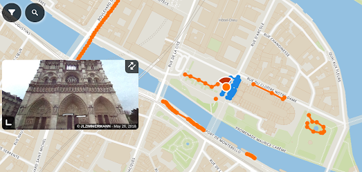
Before we get started let's have a look at the finished map that we are going to create:

A Mapbox Map with Mapillary Images

This little interactive map allows you to explore photographs uploaded to Mapillary around the White House in Washington D.C.. Click on any of the map markers on this map and you can view the selected image directly on the interactive map.

Now let's get building ...


1. Sign Up for a Mapillary API Key

Before you can start using Mapillary photographs on your interactive map you will need a Mapillary API client ID. The Mapillary Blog has a great introduction into how you can register for your free Mapillary API account. Before starting to create your own map you should read Global access to map data with the Mapillary API and follow the provided instructions for opening a Mapillary account and getting your very own client ID.


2. Make a Mapillary API Call

Once you have a client ID you can start using the Mapillary API to make an API call. For our map we want to get photographs which have been uploaded to Mapillary near to the White House. Here is our API call:

https://a.mapillary.com/v3/images?client_id=<YOUR_CLIENT_ID>&closeto=-77.03655123710632,38.8976629708&radius=250


This call will return a GeoJSON doc with Mapillary images within a search radius of 250 metres from the White House (Longitude: -77.03655123710632, Latitude:38.8976629708).

- Remember to insert your own client ID into the above URL.


3. Save the GeoJSON and Upload it to Mapbox Studio

Once you have made your Mapillary API call the GeoJSON will be displayed in your internet browser. Save this as a GeoJSON file. Once you have saved the GeoJSON document you can display it using any interactive map library. For my map I uploaded the saved GeoJSON as a tileset in Mapbox Studio.

Saving the GeoJSON as a Mapbox Studio tileset allows us to add the Mapillary images as a layer in Mapbox GL.
map.on('load', function() {
   map.addLayer({
     id: 'san',
     type: 'circle',
     source: {
       type: 'vector',
       url: 'mapbox://gmapsmania.carbekh7'
     },
     'source-layer': 'centralpark-a2pen7',
         paint: {
     'circle-opacity': 0.8,
     'circle-color': 'blue'
   }
   });
 });
The code above displays the GeoJSON data on a Mapbox map as small blue circles.


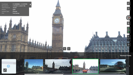
4. Turning Data into Photos

The GeoJSON data we downloaded from Mapillary doesn't actually include the URLs for the Mapillary images. However it does include the key used in the URL for each image. Mapillary image URLs take the form of:

https://images.mapillary.com/<KEY>thumb-1024.jpg

In order to display the correct Mapillary photograph when a user clicks on one of the blue circle markers we need to use a Mapbox data expression to grab the key for the photograph from the GeoJSON and then use that key to call the correct Mapillary image URL:
map.on('click', function (e) {
       var text = map.queryRenderedFeatures(e.point,   { layers: ['san'] });
       var title = text[0].properties.key;
       document.getElementById('plate').innerHTML = '<img   src="https://images.mapillary.com/' + title + '/thumb-1024.jpg" height="337">';
});
This function simply queries the GeoJSON for the correct key and then displays an image from Mapillary using that key.

You can see the finished map in action at A Mapbox Map with Mapillary Images. If you are still confused can explore the whole code for the finished map displayed directly beneath the map.

Friday, August 07, 2020

Virtual Tours of the World


Over the last few months I've been slowly curating a list of my favorite virtual tours of museums & galleries across the world. This list provides links to virtual tours created by museums and galleries around the globe, using a variety of technologies, such as 360 degree panoramic imagery. Of course I'm not the only cultural vulture who has been scouring the world's museums for interesting content. During lock-down a number of interactive maps have sprung-up which provide links to the best virtual tours created by the world's cultural institutions.

Gez.la is one of these interactive maps of cultural virtual tours. It provides links to virtual content created by museums, galleries, aquariums and zoos around the world. The virtual tours on Gez.la can be filtered by category and by country, which makes it very easy to search for the kinds of venue which you are most interested in. Another really useful feature of Gez.la is that is keeps a record of which tours you have visited. This means that if you return to Gez.la after a few days you can quickly see which virtual tours you have already visited.


Digital Museums is another interactive map dedicated to curating the best interactive content being created by the world's museums. This map is part of a project looking at museum digital strategies developed in response to lock-down, which is being led by Dr Chiara Zuanni at the University of Graz. On this map content is categorized into 'virtual tours', 'streaming content', 'online exhibitions' etc.

Virtual Museums has also created an interactive map of virtual tours created by cultural institutions around the globe. If you create an account with Virtual Museums you can create a favorites list and track which virtual tours you have visited. Virtual Museums also includes an option to submit missing virtual tours via a very short form.

Wednesday, August 05, 2020

From Mountain High to Valley Low


Over the last few months, during lock-down, I have been enjoying expanding my horizons by exploring virtual tours of the world's museums. However it is not healthy to spend so much time inside - even virtually. Sometimes you also need to virtually explore the great outdoors.

Google Art & Culture's The Hidden Worlds of the National Parks takes you on a virtual journey to parts of America's National Parks that you normally don't get to see. This extended virtual tour uses a combination of Street View, 360 degree video, sound recordings and photographs to reveal some of the hidden wonders of nature in five of America's many National Parks.

There are five virtual tours in The Hidden Worlds of the National Parks. These are:
  • Kenai Fjords National Park in Alaska
  • Hawaii Volcanoes National Park
  • Carlsbad Caverns National Park in New Mexico
  • Bryce Canyon National Park in Utah
  • Dry Tortugas National Park in Florida 
On each of these five separate tours of the National Parks a Park Ranger takes you on a virtual journey to see some of the park's hidden wonders. For example in the Dry Tortugas tour you get to dive underwater to view a shipwreck, a coral reef and also get to visit a civil war era fort. In Carlsbad Caverns you get to experience the incredible flight of thousands of bats. In Hawaii you can fly over flowing lava. In Alaska you can Kayak through icebergs and in Utah you can ride on horseback through a canyon.


After diving through a shipwreck you are probably ready to climb El Capitan. In 2015 Google decided to climb El Capitan in Yosemite. El Capitan, Yosemite is an incredibly thrilling Street View tour up the 3,000 foot vertical cliff of El Capitan in Yosemite National Park. To capture this vertigo inducing panoramic imagery Google employed the help of three experienced climbers: Lynn Hill, Alex Honnold and Tommy Caldwell. Are you brave enough to join them by undertaking this virtual Street View climb? The reward is some astonishingly beautiful views.

If you enjoyed exploring the great outdoors with these virtual tours you may also enjoy Submarine Streetview, which looks at the virtual tours created by U.S. aquariums & zoos and also at the wonderful underwater Street View imagery available on Google Earth's The World's Ocean collection.

Thursday, July 30, 2020

The Future of 3D Tours


Over the last few months I have spent a lot of time exploring 3D tours created by museums and art galleries around the world (here is a list of links to museum virtual tours). A lot of these museum virtual tours were created with the Mattterport, 3D data platform.

Matterport is an easy way to capture imagery and create a 3D tour. It allows you to capture your own imagery and create what are essentially custom Street View tours from this imagery. However Matterport tours can be a little disappointing. Using a Matterport virtual tour of a museum is a little like exploring a museum on Street View. It simply allows you to navigate around a series of static photographs. It isn't really a truly immersive experience.

To create a truly immersive 3D virtual tour you need to use photogrammetry. Using photogrammetry you can reconstruct a space in 3D and then explore it from any angle. The New York Times Research & Development team has created an awe inspiring demonstration of photogrammetry in action.

In Reconstructing Journalistic Scenes in 3D you can explore a New York loft and a shanty town in Haiti in immersive 3D. In these two 3D tours you can see how photogrammetry can be used to create narrated 'scrollytelling' like tours around a 3D scene. You can also see how you can add annotations and interactive elements to objects in the scene, so that users can explore the scene for themselves.

The problem with photogrammetry is it involves a lot of work. You need to capture extensive overlapping photographic images of the location that you wish to map. You then need the photogrammetry software to stitch all these images together into a seamless 3D scene. And you need the programming skills to be able to create a useful 3D tour of your photogrammetry scene.

As you can see from the NYT's examples the results are really astonishing. The NYT's article includes a few tips on how to make the process easier and how to deliver the finished 3D scenes to different devices and different bandwidths. Even so creating tours like these still requires an incredible amount of work. For most users looking to create a 3D tour Matterport is going to be the easier and more realistic option.

Thursday, July 02, 2020

Submarine Streetview


During lock-down I've been regularly linking to virtual tours created by museums and art galleries around the world. This week, however, I've decided to take a little break from culture and to spend a little time with nature instead.

For example, this morning I took a little virtual tour of the National Aquarium in Baltimore. The National Aquarium reopened yesterday so you can visit the aquarium for real if you are in the area. However, if you can't get to Baltimore, you can still visit the aquarium virtually on its fantastic customized 'Street View' tour.

Using the National Aquarium virtual tour you can view 360 degree panoramic images of the aquarium and virtually visit the Atlantic Coral Reef, Shark Alley the Amazon River and view all kinds of marine life, including the aquarium's amazing dolphins and sharks.

If you want live views of marine life then you might enjoy the webcams of the Georgia Aquarium and the Monterey Bay Aquarium. The webcams in these two aquariums give you a live view of lots of different marine species, including (but not limited to) beluga whales, sharks, sea lions and turtles.


You can also take a virtual dive beneath the world's oceans on Google Street View. Over the years Google has captured a number of under water Street View images in many different locations around the world. You can explore Google's under water Street View imagery on Google Earth's The World's Ocean collection.

This collection includes Street View imagery from the Great Coral Reef, the Indian Ocean, the Pacific Ocean, the Mediterranean and from many other marine locations around the globe. While exploring these 360 degree panoramic images shot beneath the waves you can virtually swim with all manner of exotic and colorful marine life.


Art Galleries and Museums

If you want some culture with your nature then you can explore many of the world's best museums and galleries during lock-down using their virtual tours. Here are a few more that you might enjoy:

The Metropolitan Museum of Art - includes a number of virtual exhibitions
The National Gallery - London's National Gallery has a number of virtual tours
The Rijksmuseum Masterpieces Up Close - a virtual tour of the museum's Gallery of Honour
The Sistine Chapel Virtual Tour - explore the Sistine Chapel and Michelangelo's astonishing ceiling
The Smithsonian National Museum of Natural Museum - has created a number of virtual tours
The Stonehenge Virtual Tour - places you in the center of this mysterious pre-historic monument
Beijing Palace Museum - the Palace Museum has created a number of virtual tours which allow you to explore some of the museum's galleries and also some of the amazing buildings of the Forbidden City
Buckingham Palace - take a virtual tour around the Queen's favorite pad