Showing posts with label Hungary. Show all posts

Saturday, February 24, 2024

The Street Names of Budapest

map of Budapest with streets colored to show which are named for men and which were named for women

Over 2,600 locations in Budapest have place-names which derive from people. Names and Spaces - Budapest is a fantastic mapped analysis of who Budapest's streets and public spaces were named after and what this reveals about the city's history.

The map is in Hungarian but works fairly seamlessly with Google Translate in Chrome. If you don't have access to Google Translate then you can still enjoy Atlatszo's recent article about the map on the European Data Network. The article, Poets, Politicians and Saints: Budapest's Changing Street Names, takes a detailed dive into the history and politics of the 8,598 streets and squares which have been renamed at least once in Budapest's history.

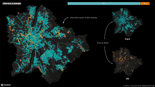
The interactive map actually allows you to explore the names of Budapest's streets for yourself. Click on a colored street on the map and you can read a short biography of the person who the street was named for. The map also provides a guided tour of some of the data behind the map. For example, like nearly every other city in the world Budapest doesn't like women very much. In fact 93% of streets named after people in the city are named for men.

Further analysis in the map explores the number of statesmen, politicians, writers, scientists etc who have roads named after them; how many Hungarian streets are named for real as opposed to fictitious people; and the political periods in which place-names have been most altered.

If you are interested in the derivation of place-names then you will love the many other maps listed under the toponym tag on Maps Mania. If you are interested in the sexist street naming histories of other cities then you can explore the many maps produced by Geochicas on Las Calles de las Mujeres and by contributors to the Mapping Diversity project. Both of these projects have created a number of maps which visualize the inequality of streets named for men and women in cities around the world.

Wednesday, February 02, 2022

The Sexist Streets of Budapest

Last week I published in The Sexist Streets of the World what I thought was a fairly comprehensive list of interactive maps visualizing the sexist traditions of street naming in cities around the globe. That post includes interactive maps which show how in city after city there are more streets named for men than there are streets named for women. However that list wasn't quite as comprehensive as I thought, as I omitted the very impressive 'Names & Spaces: Budapest'.

Names & Spaces: Budapest is a fascinating mapped analysis of the street names (& other public spaces) of Budapest.This map reveals that in Budapest 90% of streets which have been named for people have been named for men. Only 10% of the city's roads named for people have been named for famous females. This is almost exactly the same percentage (9%) of streets that has been named for fictional characters. In Budapest 208 public spaces have been named after fictional characters and only 224 public spaces have been named for  women.Of the 224 public spaces which have been given female names only 123 are named after real women.Therefore there are more streets in Budapest named for fictional characters than there are streets named after real women.

Names & Spaces: Budapest also looks at the number of streets named for Hungarians (1,816) and the number named for foreigners (206). The map also breaks down the city streets named for people by occupation. Of the different occupations recognized in Budapest's street names writers & poets have the most city streets. The next most recognized occupational group is statesmen & politicians. Soldiers and artists are among some of the other occupations which feature prominently in Budapest street names. 

Further analysis explores the periods of history with the most people represented in Budapest's street names. This analysis also looks at the history of renaming streets and public spaces. For example after the country's transition to democracy in 1989 many public spaces were renamed to replace streets and squares named for communist heroes. 

Via: The Data Vis Dispatch

Monday, August 19, 2019

A Game of Hungarian Thrones


Tomorrow Hungary will celebrate St. Stephen's Day. The day commemorates the foundation of the Hungarian state. On this day Hungarians remember Stephen I, the first king of Hungary and founder of the Kingdom of Hungary. St Stephen became king of Hungary in 1001. For the following 917 years Hungary was ruled by a succession of monarchs, until Charles IV renounced participation in state affairs in 1918.

You can explore the history of Hungary's royal kings and queens on Atlo's Battle of Thrones. This detailed history of the Hungarian royal families includes a number of data visualizations including family trees and an interactive map. The map shows the places where each of Hungary's royal rulers was born and died. It reveals that the Hungarian royal family have originated from all across Europe. In fact even the second king of Hungary, Stephen I's successor, Peter of Venice, was born in the Republic of Venice (he wasn't the only Hungarian king born in Venice - Andrew III was also a native of the republic).

Other Hungarian kings have been born in what is now Spain, Romania, Italy, Germany, Poland and  elsewhere across the continent. On the map the red circles show where a monarch was born and the blue circles indicate the monarch's place of death.

Friday, August 02, 2019

The Dot Map of 1910 Hungary


The Native-Ethnic Composition of Hungary in 1910 is a dot map showing the native languages of Hungarians in 1910. The map is based on data from the 1910 Hungarian census. On the map one dot represents one person and the different colors represent the different languages spoken by Hungarians in 1910. The languages shown are Hungarian, German, Serbian, Croatian, Romanian, Slovak, Ukranian and Slovenian.

The 1910 census was the last census in Hungary before the 1920 Treaty of Trianon. After World War I the Treaty of Trianon was the peace treaty between the allies and the Kingdom of Hungary. The treaty led to the break-up of much of Hungary (after the treaty was signed Hungary was round 28% of the size of pre-war Hungary). One of the principle aims of the treaty was the doctrine of 'self-determination of peoples', and the treaty attempted to give non-Hungarian speakers their own national states or to cede the territories where they lived to the countries of their mother tongues. The Hungarians didn't exactly sign the treaty willingly.

On the map you can see how many areas with a high density of non-Hungarian speakers in 1910 correspond to modern day country borders. For example, in the north the high density of Slovak speakers corresponds pretty accurately to the borders of what is now Slovakia. In the east the high density of Romanian speakers seems to correspond fairly closely to the the borders of modern day Romania. Although in the far east of 1910 Hungary, in the Burzenland area of Romania, there was a high density of both Hungarian and German speakers in 1910 (German speakers have lived in this region since the 12th century).

Thursday, February 21, 2019

The History of Settlements in Hungary


Partly inspired by the New York Times' popular Map of Every Building in America the Atlo data visualization team decided to undertake a detailed examination of the street patterns of urban settlements in Hungary. In Roads, Buildings, Networks Alto looks at the different types of settlement morphology and the history of urban growth and planning in the country.

Roads, Buildings, Networks includes an interactive map which shows only the outlines of building footprints and roads. The data for this map comes from OpenStreetMap. Unfortunately the building footprint data for Hungary on OSM can be a little patchy, however the Atlo map does provide an interesting view of the street patterns of Hungary's urban settlements.

Accompanying the interactive map is a very detailed explanation of how terrain, hydrography, history and other factors have helped shape Hungary's different urban environments. Through this exploration of settlement morphology Atlo identifies distinct forms. These include the spherical street patterns of the historic mining towns and the regular chessboard-like street patterns which resulted from the urban planning which began in the 17th century,

Wednesday, February 20, 2019

Mapping the Approaching Apocalypse


Magyarország Húszezer év Múlva (Hungary in 20,000 Years) is a collection of four interactive maps which imagine what a post-apocalyptic Hungary might look like. I have no idea why living under the rule of Viktor Orbán would make Hungarians think about the end of the world, but the pessimistic developers of these maps have imagined four different scenarios that could lead to the end of human existence and then mapped out how these scenarios might change the way the world will look.

The Mad Max scenario (pictured above) imagines a Hungary which has succumbed to desertification after global warming or a nuclear war. The Water World scenario maps Hungary after some really dramatic rising sea levels. The Holnaputan scenario pictures Hungary in a future ice age. Finally the Jurassic Park scenario imagines a world which has returned to nature after the disappearance of man.


Each of these four Hungarian maps were created using Mapbox Studio which makes it very easy to change the colors of different base-map layers. Another example of changing different map features is Hans Hack's Green Berlin. This map changes the roads of Berlin into canals and footpaths. Every single piece of concrete in the city seems to have been replaced with grass on the Green Berlin map.


Another glimpse into the post-apocalyptic future can be found on Frequency 2156. Frequency 2156 is a radio station and Google Map that has been transmitted back through time from the year 2156. In the year 2156 the world is suffering from a twenty year long nuclear war.

Frequency 2156 appears to be gathering data about survivors of this global nuclear war. The map allows you to listen to the messages sent into the station from survivors around the world. You can really mess with the heads of those survivors by recording your own message on the map. Your message will then be transmitted forward through time to this future dystopian world.

Saturday, December 15, 2018

Breaking Through the Bronze Ceiling


You may have heard of the Guerrilla Girls, who have been campaigning against the under representation of female artists in art galleries around the world. Back in 1989 the Guerrilla Girls surveyed all the works of art in New York's Museum of Modern Art. They discovered that less than 5% of the artworks in the Modern Art Department were by female artists. While 85% of the nudes featured in those artworks were female.

Women aren't only under represented inside art galleries. You probably won't be too surprised to hear that they are also under represented in those works of art that are displayed in public spaces. For example in Budapest there are more statues of animals than there are statues of women.

Atlatszo has analyzed all the statues that are owned and maintained by the municipality of Budapest. Of the 1,173 statues in the streets of Budapest 785 depict men. Only 150 statues depict women. A large proportion of the statues depicting men are of historical figures. Only 35 of the 1,173 statues in Budapest are of named historic women. The majority of the other statues of women are unnamed nudes. You can find out where all 150 statues depicting women are on the streets of Budapest on an interactive map in Atlatszo's Data Visualization of the Hungarian Bronze Ceiling.


Women aren't only under represented in artistic memorials. They are also under represented in the very names we give to the streets in which we live. For example an analysis of the Street Names in Vienna reveals that 4,269 streets have been named for men. Only 356 have been named for women.

Geochicas have also been investigating the under representation of women in street names. Their Las Calles de las Mujeres is an interactive map which shows all streets named for men and women in a number of Spanish and Central & South American cities. A pie chart on each city's map shows the percentage of streets named for both men and women in that city.

Mapbox has also created an interactive map showing the distribution of male and female street names in major cities across the world. According to Mapping Female versus Male Street Names if you add up all the streets in Bengaluru, Chennai, London, Mumbai, New Delhi, Paris, and San Francisco only 27.5% are named after women.

Friday, May 25, 2018

The Virtual Globes Museum


The Virtual Globes Museum is a website which allows you to view historical vintage globes as interactive virtual WebGL 3d globes. The collection includes Earth and celestial globes dating back to 1507.

The first globe in the collection is the 1507 Waldseemüller globe. This was the first globe known to include the word 'America'. The label 'America' is placed on what we now call South America. The collection also includes a number of Earth and celestial globes by the Dutch cartographer Willem Blaeu and by the Venetian Vincenzo Coronelli.


The University of Lausanne in Switzerland has released two interactive 3d globes which are digitized versions of the University's globes made by Gerard Mercator in the 16th century. The two recently discovered globes exist as a homogeneous pair, one being a terrestrial globe and the other a celestial globe.

The University has used Esri's Scene Viewer to create their two interactive 3d globes from Mercator's originals. This allows you to inspect Mercator's Earth Globe and Mercator's Celestial Globe in detail from your own browser. The Earth globe is made from plates engraved by Mercator in Louvain in 1541.

Mercator's Earth globe improves significantly on the Ptolemaic view of the world which dominated during the 16th century. For example, his representation of the Mediterranean and Africa are much more accurate than many other contemporary maps based on Ptolemy.


The State Library of New South Wales has also created a couple of interactive 3d globes from vintage historical maps and globe gores. Their Meridian application allows you to view virtual globes of Miranda's World Map (1706) and Coronelli's Terrestial Globe.

Meridian was created using the Three.js library. You can read more about how Meridian created their virtual globes from Miranda's two dimensional vintage map and from Coronelli's globe gores on the DX Lab blog.

Monday, April 09, 2018

Hungarian Election Maps


Hungary’s anti-immigration Fidesz party has gained a spectacular victory in the Hungarian national election. Viktor Orbán has won a third consecutive term as Prime Minister. Orbán's Fidesz party campaigned almost exclusively on the supposed dangers that Hungary faces from immigration.

The only interactive map of the election that I could find is in the daily newspaper Magyar Nemzet. The map spectacularly visualizes Orbán's almost complete clean sweep outside of Budapest. The small inset map showing Budapest shows that the Hungarian Socialist Party (MSZP) and Together (Együtt) did at least have some success in the capital.

If Orbán manages to win 133 of the parliament’s 199 seats he will achieve what is known as a super-majority. This will allow him to make changes to the Hungarian constitution. Orbán has already taken over much of the media in Hungary and with a super-majority the opposition parties are worried that he will start making anti-democratic changes to the constitution.

Friday, March 09, 2018

The Dog Map Dot Map


The European Population Density map is a dot density map which shows the population density of people in Europe. Each dot on the map represents 50 people. However the map completely fails to show where all the dogs live in Europe.

One Dog One Dot is an attempt to address this problem. At least for the capital of Hungary. One Dog One Dot is an interactive dot map showing where dogs live in Budapest. On this interactive map one dot equals one dog.

If you click on a dot on the map you can view the selected dog's name. It is important to note in order to ensure doggie privacy the locations of all dogs are randomized within each neighborhood. Therefore the dots don't show the exact address of each dog.

I don't know anything about Budapest housing. Therefore I'm unable to read much into the density of dogs in Budapest. The map's creator says that "there is no question that more dogs live in flats than in family houses". I just feel sorry for all those dogs living in the Danube.

Tuesday, September 09, 2014

Bubi Maps


Yesterday Budapest became the latest city to unveil its own bike sharing scheme. Budapest's bike sharing network, called 'Bubi', consists of 76 docking stations and 1,100 bicycles.

The Budapest bike sharing network's website Mol Bubi has released a Leaflet map showing the location of all 76 docking stations. If you select a station's marker on the map you can find out how many bikes are currently available. The markers are color coded to show stations that have bikes available (red) and stations which currently have no bikes (black).

Oliver O'Brien's global Bike Share Map also now includes Budapest's Bubi bike sharing scheme. The Bike Share Map also shows how many bikes are currently available at each station and also tells you how many free docking spaces are available, for those wanting to return a bike.

The Bike Share Map uses a different color-coding system for the bike station markers. Markers are shown using shades from blue (empty) to red (full) to give an overview of how many bikes are available at each station (you can mouse-over the station to find out the exact number).

The Bike Share Map also provides a line graph which shows the amount of activity over the last 24 hours based on the number of bikes being borrowed.

Wednesday, April 09, 2014

Real-Time Trams in Budapest


Hungarian map portal Utcakereso has now added the option to view the locations of live buses, subway trains and trams in Budapest. Utcakereso is an OpenStreetMap based mapping portal to Hungarian addresses, businesses and real-estate property. The site now includes the option to view BKV (the Budapest public transit system) vehicles moving in real-time.

The live public transit option allows you to click on the animated vehicles on the map to view their estimated times of arrival at their next scheduled stops. When you select a vehicle's marker the vehicle's route is also highlighted on the map. You can also click on stations and bus-stops to view which lines they service.

Monday, March 17, 2014

Hungary for Art


There is a great collection of public art in this Hungarian Google Map. Kozterkep is a crowd-sourced map of outdoor sculpture, mainly in Hungary but also highlighting other well known public art throughout Europe.

The map showcases sculptures that are in public spaces and which can be accessed for free. Anyone can submit the location and details of a sculpture to the map but Kozterkep retains editorial control. This ensures that the details and information about each work of art are both accurate and informative.

Each mapped sculpture includes at least three photographs of the artwork, information about the artist and and a brief description of the submitted art.

Saturday, October 19, 2013

High Resolution Aerial Imagery Mapping


This map of the Military Memorial Park in Pákozd, Hungary claims to be "the world's highest spatial resolution aerial orthophoto map produced by aeroplane". I don't know if that is true or not but I do like the map.

Aerial Record use the Google Maps API as a means of presenting the high resolution aerial imagery as a slippy interactive map. This means that users can zoom in and pan around the image as they would do a normal Google Map.

The aerial imagery itself really is of high resolution. If you zoom in on individuals on the map you can almost see the color of their eyes.


The image also contains a number of descriptive overlays. If you turn on 'descriptions' when you zoom in on features in the park you can find out more about them by reading the provided information

Hat-tip: Google Street View World

Tuesday, April 23, 2013

Street View Arrives in Hungary and Lesotho


Széchenyi Thermal Bath

Street View is now available in 50 countries worldwide.

Today Google Maps made its biggest ever update to Street View, adding new and updated imagery for nearly 350,000 miles of roads across 14 countries. This update includes new Street View imagery in France, Italy, Poland, Romania, Russia, Singapore and Thailand. It also includes the launch of Street View in Hungary and Lesotho.


Lesotho

Via: Google Lat Long

Tuesday, September 06, 2011

Hungarian Trains Live on Google Maps


Hungarian railways MAV could be the first rail company to launch their own real-time Google Map showing the live position of passenger trains.

A number of individuals have created real-time maps of moving trains by scraping train data from operators' websites and some train operators have even released their own APIs. However MÁV-START Vonatinfo is, I think, the first live Google Map of trains actually released by a train operator themselves.

The map shows the live real-time positions of all trains on the Hungarian rail network. You can click on any of the trains to view its full timetable. The trains themselves are colour-coded to indicate if they are currently running on time or are delayed.

If you select 'Vonat' you can search for an individual train. Enter a train number and the train's timetable is displayed and the map zooms to the selected train's track. If you select 'Állomás' you can search for and view an individual station's timetable.

______________