How Well Do You Know Your Neighborhood?

To participate in Help Us Map New York's City's Neighborhoods you just need to center the interactive map on your home (the map bounds is restricted to New York City). You are then asked to give the name of your neighborhood and enter how many years you have lived at that address. Then, by simply clicking on the map, you are asked to draw a line around your neighborhood.
The New York Times are not the first organisation to survey local knowledge about local boundaries using an interactive map. In fact a few years ago DNA Info ran a very similar survey asking their readers to draw the boundaries of New York neighborhoods. In September of this year Axios also asked its readers to draw the outline of their local neighborhood on an interactive map.

There are twenty U.S. cities to play in Axios' Draw Your Neighborhood, including San Francisco, Philadelphia, Dallas and Chicago (but not NYC). After you select a city you are then asked to draw on an interactive map the boundaries of five city neighborhoods. When you have drawn all five you can view a map showing the average boundary for each neighborhood (as drawn by other players) and are given a percentage score for each neighorhood indicating how different your guess was from the average.
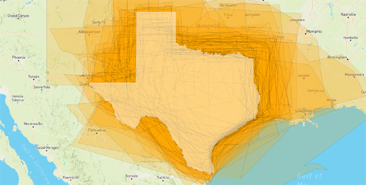
It is actually very easy to create your own map survey. Two years ago I created my own map survey Where is Texas, which asked people to draw the border of a whole state. You can clone my map to create your own map survey for any location on Earth (just click on the fish logo on the map and select 'Remix on Glitch' to create your own editable instance of the map).
If you are interested in the results of my map survey then take a look at Here is Texas. This map shows all the entries submitted to my Where is Texas map survey. The real border of Texas is also shown as a white polygon on the map.


Comments