вторник, июня 30, 2020

Create an Earth Club Sandwich


In 2006 Ze Frank challenged the viewers of his video show to create an Earth Sandwich. He wanted two people on opposite sides of the Earth to create a sandwich - using two pieces of bread with the whole of planet Earth in between.

To help people create this Earth Sandwich Ze Frank created an interactive map which could find the antipode for any location on Earth. Ze Frank's map no longer works but there are many other maps which can help you find what is on the exact opposite side of Earth from your location. For example, if you enter your location into the Antipodes Map you can discover its antipode. Then (if you can find a willing volunteer on the other side of the Earth) you can make your own Earth Sandwich.


If you want a more upmarket snack (an Earth Club Sandwich if you will) then you can use Around the World instead. This clever interactive tool can find your antipode and also provide you with a little more information about that whole world which lies between you and your antipode.

Enter a location into Around the World and you are shown a globe with your location and its antipode highlighted. On the surface of this globe you can see what you would encounter if you walked from your location via the North or South Pole to your antipode.

Water bodies are shown on the surface of your globe in blue and land is shown in green. Elevation and depth are shown by the height and depth of the green and blue lines. In the center of the globe you can view a few more interesting facts about the journey from your location to its antipode. For example you can see how many countries lie in between your two antipodes and also how many miles of land and sea you would have to cross if you wanted to travel between the two.

The Virtual Hajj


This year, because of the coronavirus outbreak, the Hajj pilgrimage has been limited to only one thousand pilgrims. For Muslims the sacred Hajj pilgrimage is an essential life journey, a trip which they must make (if they are capable) at least once in their lifetime.

The Kontinentalist has created an interactive story map, Inside the Sacred Hajj Pilgrimage, which explains how people undertook the Hajj in the age before air travel. Before the age of flight pilgrims would often travel by kapal haji (ships). For many Muslims traveling from Southeast Asia Singapore was an essential hub for the journey to Mecca. Pilgrim brokers, boarding houses, and stores in Singapore all catered to the needs of the many pilgrims taking the Hajj.

The Kontinentalist article also maps out a step-by-step guide to the Hajj. Using another story map the article explains some of the rituals, journeys and prayers that pilgrims must make over the many days of the Hajj.

Nowadays of course many pilgrims undertake the journey to Saudi Arabia by plane. The Kontinenalist explains how the numbers taking the Hajj has surged since of the advent of air travel. In fact since 1988 Saudi Arabia has introduced a quota system to manage numbers, issuing one pilgrimage visa for every 1,000 Muslims in each country.


Despite the quota system millions of people still make the annual pilgrimage to Mecca by plane. In Flying to Hajj Al Jazeera visualizes and explores the 16,888 flights made to Mecca during last year's annual pilgrimage. The map shows the thousands of flights from all around the world which converge on Mecca during the  Hajj.

To reach Mecca many pilgrims fly to Jeddah,  the nearest airport, which is 80 km from Mecca. Alternatively pilgrims fly to Medina to visit the Prophet's mosque at al-Masjid an-Nabawi, before then completing the 450 km trip south to Mecca. Al Jazeera's Flying to Hajj map visualizes over 10 million individual GPS co-ordinates from all inbound flights to Jeddah and Medina over the Hajj period. On the map you can view the tracks of individual planes arriving from all around the world as they approach and land at Jeddah and Medina.

The country with the most flights to Jeddah and Medina last year during the Hajj was Egypt, with 1,618 flights. The UAE, Pakistan, Turkey and India, in that order, sent the next most flights to Mecca. The top three airlines (by number of flights) were Saudia, Turkish Airlines and EgyptAir.

понедельник, июня 29, 2020

The US High Poverty Map


During the current economic downturn neighborhoods which are already economically vulnerable will most likely be hit the hardest. The Economic Innovation Group's High Poverty Map is an interactive map which visualizes the metro neighborhoods in the United States which had high levels of poverty in 2018 and those which were in high poverty in 1980 but have since successfully turned around.

On the interactive map high-poverty census tracts are colored to show if they are newly poor, persistently poor, deepening poverty or turned around. If you select one of these colored neighborhoods you can view the poverty rate in that census tract for the years 1980, 1990, 2000, 2010 & 2018.

Alongside the interactive map the Economic Innovation Group has published a number of city profiles. These profiles provide a detailed analysis of poverty levels in some of America's largest cities. For example the city profile for New York notes that although the city still has a high number of neighborhoods in poverty the number of high-poverty neighborhoods has dropped sharply since 1980. In Los Angeles the number of high-poverty neighborhoods has increased a lot since 1980. Unlike New York it has seen very few neighborhoods transition from high-poverty to low-poverty.

Placename Pronunciation Maps


Traveling in Wales can be difficult for non-Welsh speakers. For example how exactly do you ask for directions to Llanfairpwll-gwyngyllgogerychwyrndrob-wllllantysiliogogogoch. If you also have problems pronouncing Welsh placenames then you might appreciate Map Llais.

Map Llais is an interactive map which provides audio recordings which allow you to hear how you should pronounce the names of towns and villages in north-west Wales. If you click on any of the map markers you can listen to how the name of the selected town or village should be pronounced.

Map Llais uses sound recordings uploaded to Wikimedia. The map doesn't entirely answer my question about the pronunciation of Wales' longest placename. The map uses the shortened version of the town's name, Llanfairpwllgwyngyll, and therefore only provides the sound recording of this shortened form.


There have been many interactive maps created over the years which have been designed to help you pronounce placenames. In the past I've linked to maps with sound recordings of Māori placenames, Canadian placenames and even a global map of placenames using sound recordings from Forvo, the online pronunciation dictionary. Unfortunately none of those maps are still active.

The only other map I know of which helps you learn how to pronounce placenames correctly is the Squamish Atlas. The Squamish Atlas is an interactive map in the Squamish language. On the map all the map labels are written in Squamish. The mountains and waterways are in Squamish, the islands and villages are all in Squamish and the landmarks are in Squamish.

If your Squamish is a little rusty then you can click on the placename labels and the map markers to find out how to pronounce the name and to learn what it means in English. Many of the Squamish names and markers on the map have audio files attached which allow you to hear how the word should be pronounced correctly.

суббота, июня 27, 2020

The Earth Impacts of Covid-19

We all know the devastating impact that Covid-19 has been having on people's lives around the world. We are also profoundly aware of the economic impact that Covid-19 lock-downs are having on the global economy. Perhaps less understood is the impact that these lock-downs and this reduced economic activity is having on the Earth's environment.

Early on in the Covid-19 outbreak NASA revealed how air pollution in China and northern Italy had improved, most probably as a consequence of the shut-down of industry and the huge reduction in road traffic. Now NASA has teamed up with the European Space Agency and the Japan Aerospace Exploration Agency to document and visualize the other environmental effects of the COVID-19 pandemic on planet Earth.


Water quality in the Venice Lagoon has improved during the Covid-19 outbreak

The Covid-19 Earth Observing Dashboard uses remote sensing data from ESA, JAXA and NASA to investigate and show how Covid-19 lock-downs have affected Earth’s air, land, and water. For example all three space agencies monitor water quality by measuring Chlorophyll-a (Chl) concentrations using satellite optical sensors. These sensors show that in many locations around the world water quality has improved during the Covid-19 outbreak.

The Venice Lagoon in the North Adriatic is usually subject to heavy cruise ship activity. The water quality in the lagoon is also heavily effected by run-off from the Po River, which runs through many different industrialized areas. The decrease in maritime tourism in the lagoon and industrial activity along the Po River during the outbreak has seen unusually low levels of Chl concentration in the Venice Lagoon.


Air quality has improved in many areas of the United States

Air Quality has also improved in many locations around the world. The Covid-19 Earth Observing Dashboard shows that the Northeast United States has seen a 30% drop in NO2 levels compared to the average levels in the previous 5 years. Similar reductions have been seen in Europe, China and India during Covid-19 lock-downs.

You can use the Covid-19 Earth Observing Dashboard to explore the environmental impacts of Covid-19 lock-downs for yourself. The map allows you to search for examples geographically. You can also use the 'indicators' menu to search for examples by environmental, agricultural and economic impacts.

пятница, июня 26, 2020

How America Was Lost to Covid-19


The New York Times has published a damning story map which visualizes America's failure to stop the spread of Covid-19. In How the Virus Won the NYT shows how a few thousand cases of Covid-19 in February was over the next few months able to spread almost unchecked across the United States. Using animated flow maps the newspaper effectively shows how a lack of leadership and a failure to act quickly enough allowed Covid-19 to spread to all parts of the USA.

As you progress through the NYT's story map you can see the number of Covid-19 cases spreading across the country, while the NYT explains why the virus has not been contained. One of the major reasons why the USA has failed to 'flatten the curve' is that public officials have always been a few steps behind the outbreak. Mainly because they have been led by a President who has been determined to ignore the threat of the virus to people's lives.

Early on Donald Trump decided that he didn't want to disrupt the economy. For example in February the U.S. government told their citizens to continue traveling domestically and to continue with their normal lives. In How the Virus Won the NYT shows how the public did exactly that. Using mobile phone data the newspaper visualizes how millions of Americans moved around the country in the first two weeks of March. Many of them undoubtedly spreading coronavirus around the United States.

For example the NYT has used genetic samples to show how the virus spread from Seattle and New York to infect people across the United States. The NYT's conclusion is clear. If the United States had introduced lock-down and social distancing earlier '36,000 deaths nationwide could have been avoided'.

Mapping International Migration Flow


International Migrant Stock in 2019 is an interactive flow map showing the number of immigrants and emigrants moving into and out of countries around the world. The map also shows the countries where all those migrants moved to and from. The map uses data from the United Nations to show which countries immigrants in each country came from and where emigrants from each country moved to.

If you select a country from the drop-down menu you can view a flow map of migration into the country and a flow map showing where emigrants from the country moved to. For example if you choose the United States you can view scaled flow lines showing the countries where U.S. immigrants have come from. The biggest flow line is for Mexico. If you click on the flow line emanating from Mexico it is revealed that around 11.5 million Mexican immigrants live in the United States.

If you switch the map to show which countries people from America are moving to you find that again the thickest flow line is between the USA and Mexico. Around 632,000 people have moved from the United States to Mexico. At the bottom of both the immigration flow and emigration flow maps for each country you can view data on the total number of immigrants and emigrants. According to the map in 2019 2.91 million people from America were living abroad and the United States had 48 million people who had migrated there from other countries.

If you want to see the immigrant and emigrant flows for other countries just select a country name from the drop-down menu in the map sidebar.

The International Migrant Stock 2019 flow map was created with R and D3.js. You can learn a little more about how the globe was created on this Flow Globe blog post.

четверг, июня 25, 2020

Exploring the Deepest Point on Earth


Challenger Deep is deep. Very Deep. Located in the Mariana Trench, Challenger Deep is the deepest known point in the Earth's seabed. But just How Deep is Challenger Deep?

John Nelson has the answer in this beautiful Esri story map which helps to explain the staggering depths of Challenger Deep. As you progress through this story map you will learn about the natural forces which created this huge depression deep beneath the Pacific Ocean. You will also learn about the kind of dark inhospitable conditions which exist at so many fathoms beneath the sea.

As is customary John Nelson's story map contains some beautiful cartography, liberally sprinkled with Nelson's own patented Firefly mapping technique and some interesting comparative illustrations.


To help convey the staggering depth of Challenger Deep Nelson uses a number of non-standardized units of measurement. This involves showing how many Everests, Manhattans or Grand Canyons deep the depression falls beneath the surface of the sea. To help illustrate these non-standardized units of measurement Nelson has stacked a number of Mount Everests one on top of the other and relocated the Burj Khalifa to the bottom of the Grand Canyon. All for a sense of scale - of course.

How Happy is the World?


People in the United States are sad. Of course emotions do vary depending on where you live in the United States. In Montana people are very sad, whereas in the neighboring states of Idaho people appear to be happy. At least that is according to the How is the World? interactive map.

How is the World is an interesting map which can tell you how people are feeling around the world. On this map countries are colored to show how the people in that country are feeling. Currently nearly 28% of the world are feeling sad and 20% are feeling happy.

Except of course they are not.

Like most of these sentiment analysis maps How is the World is complete nonsense. At the time of writing the global map is based on responses from 2,994 people. I'm no expert on sampling techniques but I suspect a 3,000 person response will not provide an accurate sample of a global population of around 7,713,468,000.

Now I am sad.

среда, июня 24, 2020

Amnesty's Video Map of Police Violence


Amnesty International says that there were at least 125 separate incidents of police violence against protesters between 26 May and 5 June. In response to what Amnesty reports as 'largely peaceful' Black Lives Matter protests the police have often used what appears to be disproportionate and indiscriminate force.

Amnesty report that the use of violence by the U.S. police has not only been severe but has also been widespread across the country. There have been violent attacks on protesters in at least 40 states. You can see where Amnesty International has reported incidents of police violence on their Incidents of Police Violence interactive map.

To compile this interactive map Amnesty International collected nearly 500 videos of the Black Lives Matter protests in the United States. These videos were then analysed by "investigators with expertise in weapons, police tactics, and international and US law governing the use of force". Where possible incidents of violence detected in the videos were confirmed through interviews with the victims and /or through police department statements.

You don't need to agree with Amnesty International's judgement on each video. The Amnesty International Police Violence map allows you to view the analyzed videos of police violence for yourself. You can therefore decide for yourself if the police violence in each incident was justified force or not.

YouTube Near You


YouTube GeoFind allows you to search YouTube videos by location. Using the GeoFind interactive map you can search for videos by location and see where each of the returned videos was shot on the very same map.

Being able to search for videos by location seems to be a great idea and on the face of it should provide really interesting results. However searching YouTube videos geographically often seems to provide disappointing results.

Over the years there have been a number of maps which allow you to search YouTube by location. None of these maps have ever seemed to have gained much traction or lasted very long. I think the main reason for this is that searching YouTube by location returns many videos which have no particular or local geographical interest.

For example I used GeoFind to search videos posted to YouTube in Manhattan. In the first ten results were videos on cooking spare ribs, make-up tutorials and how to make money on Facebook. These videos don't appear to have any real local interest and might as well have been shot anywhere in the world. In the first ten results only one video (about an NYC Justice Bike Ride) had what I would define as local interest. I think searching YouTube videos by their get-tags often provides really disappointing results. This is probably why no YouTube map has ever become a really successful app. 

вторник, июня 23, 2020

Is Your Country Democratic?


Every year Dalia Research surveys people around the world to compare people's attitudes towards democracy. The 2020 Democracy Perception Index is now out and provides some interesting insights into how people around the world perceive their own governments and the importance of democracy.

43% of people around the world say that their own government only serves a small group of people. On the map above countries are colored red to show where more than 50% of citizens think the government only serves a small minority. The countries colored green have more than 50% who disagree that their government only serves a small minority.

In the United States 52% of people think the government only serves a small group of people. The Vietnamese seem to have the most favorable view of their own government. In Vietnam only 12% think that their government only serves a small group of people.


Does the USA have a positive or negative influence on democracy?

The Democracy Perception Index also asked people around the world if the United States has a positive or negative influence on democracy around the world. Overall 44% say it has a positive influence and 38% say it has a negative influence. However what is striking is that most Western European countries and Canada & Australia all think that the USA has a negative influence of democracy.

What is also striking is that all the countries surveyed around the world think that it is likely a foreign power will influence the results of their next election. For example 55% of Americans think that the 2020 election will be influenced by a foreign power.

The Multilingual Map of the World


Country Names in Any Language is an interactive map which allows you to view an atlas of the world on which the country labels are written in the language of your choice.

Using the drop-down menu you can select from any language in the world to view a map on which the country name labels are displayed in the selected label. The country names for each language are fetched live from Wikidata and plotted on a Mapbox GL map.

Mabox GL has an option which allows map developers to present map labels in different labels (you can see it in action here). There is also the mapbox-gl-language plug-in which localizes the language of map labels to match the default language configured in the user's browser.

Country Names in Any Language only translates country names and doesn't translate other map labels (for example town and city names). If you use the mapbox-gl-language plug-in you can translate all the map labels to the language of your choice. However using the plug-in you are limited to only the language being used by the user's browser (and a limited number of Mapbox GL supported languages). Country Names in Any Language obviously has the advantage of allowing users to switch between different country names and to see how country names are written in any language of their choice.

понедельник, июня 22, 2020

Where Americans are Moving


Esri has used the latest American Community Survey to visualize where people are moving to and from in the United States. The Where are people moving? story map explores patterns of internal migration within the USA and shows you where in the country people moving into your neighborhood in the last year came from.

The visualizations include maps showing where most people moved from in each state and county. On these predominance maps parts of the United States are colored to show where new residents moved from in the past year. As you progress through the storymap patterns in the internal migration of Americans are highlighted on the map. For example many counties in Florida are colored grey showing that the majority of people moving in are Northeastern snowbirds and retirees moving to the warmth of the south.

Other patterns which are revealed by the maps are that 38% of new arrivals in California came from abroad and that Texas experienced inward migration from all areas of the United States and from abroad. As you can see in the screenshot above most inward migration actually consists of people moving within the same region of the USA.

At the end of the Where are people moving? story map is an interactive map which colors each census tract in the country to show where the most people moving into the tract in the last year moved from. This allows you to see where the majority of new residents in your neighborhood moved from.

Maps with Zealandia


The vast majority of the continent of Zealandia sank beneath the oceans around 23 million years ago. Originally Zealandia was part of the supercontinent Gondwana (along with South America, Antarctica, India, Australia, Arabia and Africa). Zealandia broke away from Gondwana between 83–79 million years ago. The vast majority of it now sits beneath the Pacific Ocean and Tasman Sea. Only the islands of New Zealand and New Caledonia remain above sea level.

It is only in the past decade that Zealandia has begun to be classified as a continent in its own right. You can now explore a number of interactive maps of Zealandia thanks to GNS Science’s Te Riu-a-Māui / Zealandia research programme (TRAMZ). Their new E Tūhura - Explore Zealandia mapping portal allows you view the whole of Zealandia - even the 94% of it which now lies at the bottom of the sea.

The interactive maps featured in E Tūhura, include a tectonic map (showing the plate and microplate boundaries of Zealandia), a bathymetry map (showing the shape of both solid land and the seabed) and a geoscience data map (featuring a number of different GIS map layers).


During the Early Permian period, Gondwana collided and joined with Euramerica (a paleocontinent made up of south Europe and North America) to create the super-continent Pangea. Pangea existed during the late Paleozoic and early Mesozoic eras, before it began to break apart about 175 million years ago. Of course there weren't any country borders on Pangea. However the land mass that was Zealandia would probably have been attached to what we now know as Australia

Pangaea Politica by Massimo Pietrobon is an interesting (if fanciful) map which overlays modern country borders on a map of Pangea. The map is at best a guesstimate of where modern countries might have been on Pangea. There are some obvious errors, for example the map includes the country of Iceland, a volcanic island which didn't exist when Pangea was around. However it is still good fun to imagine which modern countries might share borders today if Pangea had never broken apart.

воскресенье, июня 21, 2020

The 2020 Submarine Cable Map


Every year Telegeography releases a map of the current network of undersea telecommunication cables around the world. The 2020 Submarine Cable Map has now been released.

Subsea cables carry telecommunication signals under the oceans, communicating information between different countries and regions of the world. In the 19th Century the first submarine cables were laid to carry telegraphy traffic. In the 21st Century submarine cables carry digital data, which includes telephone and Internet data.

This year's map shows the location of 447 cable systems around the world and 1,194 landing stations. The 2020 map shows the planned 2Africa cable. At 37,000km in length, 2Africa will be one of the world’s largest submarine cable networks. It will connect 16 countries in Africa and five countries in Europe. The cable is expected to be working by 2023/4.

You can explore Telegeography's Submarine Cable Maps for previous years by changing the year in the map's URL. For example, one of my favorite Telegeography maps can be found at http://submarine-cable-map-2015.telegeography.com/. This 2015 map was inspired by medieval and renaissance cartography and features not only a vintage map style but sea monsters, cartouches and border illustrations.

суббота, июня 20, 2020

Buckingham Palace Street View


The website of the British Royal Family includes a virtual tour of three rooms in Buckingham Palace. Buckingham Palace is the London home of the Queen of England and the administrative headquarters of the British monarchy.

The Buckingham Palace tour allows you to explore the Throne Room, the White Drawing Room and the Grand Staircase. Each of these three 360 degree panoramic tours include information on the function of the room in the Royal household and information on some of the paintings and furniture on display.


In terms of scale the Queen's house is certainly impressive but I'm not enamored with the decor. I don't know whom the Queen used for her interior design but it all seems a little too nouveau riche for my tastes. It is almost as if someone is trying a little too hard to impress. Obviously the word 'understatement' isn't in the royal vocabulary.

One person who shared the Queen's taste in outrageously opulent design was the Sun King, Louis XIV. Louis XIV's Palace of Versailles has to be one of the most magnificent buildings in the world. This Google Arts and Culture tour of the palace allows you to explore the palace using Google Street View. You can explore each individual Street View by panning around and zooming in on the 360 degree panoramic images. Move around the palace by clicking on the navigation arrows within each of the Street View scenes.


You can explore many of the world's best museums and galleries during lock-down using their virtual tours. Here are a few more that you might enjoy:

The Metropolitan Museum of Art - includes a number of virtual exhibitions
The National Gallery - London's National Gallery has a number of virtual tours
The Rijksmuseum Masterpieces Up Close - a virtual tour of the museum's Gallery of Honour
The Sistine Chapel Virtual Tour - explore the Sistine Chapel and Michelangelo's astonishing ceiling
The Smithsonian National Museum of Natural Museum - has created a number of virtual tours
The Stonehenge Virtual Tour - places you in the center of this mysterious pre-historic monument
Beijing Palace Museum - the Palace Museum has created a number of virtual tours which allow you to explore some of the museum's galleries and also some of the amazing buildings of the Forbidden City

пятница, июня 19, 2020

The Gerrymandered States of America


Antimander is an open-source interactive application which is designed to detect gerrymandering within congressional districts. Using Antimander you can explore thousands of alternative congressional district maps to view how different electoral districts can radically alter the electoral results in different states.

Using the Antimander interactive map tool you can explore how Wisconsin's eight different districts can be redrawn to provide different electoral outcomes. In the last U.S. election the votes were fairly evenly split between the Republicans and Democrats (Trump narrowly won the popular vote) however the Republicans won 5 out of the 8 electoral districts. In other words the current electoral map in Wisconsin gives the Republican party an unfair advantage.

Antimander allows you to adjust three different metrics and immediately see how these would effect the electoral outcomes in Wisconsin. The metrics you can adjust are compactness (more complex district boundaries are a good indicator of gerrymandering), competitive elections (close races in each district) and fairness (the number of elected representatives corresponding as closely as possible to the percent of voters for each party).


If you want to know how gerrymandered your state's districts are then you can refer to Planscore. PlanScore has mapped the level of gerrymandering in all 50 states in the USA. PlanScore includes a comprehensive historical dataset of partisan gerrymandering, so you can examine the history of gerrymandering in each state and which political parties the districts have been gerrymandered to support.

The PlanScore choropleth map shows the level of gerrymandering in each state for both the House and State House elections. The darker the red or blue colors on the map then the more skewed the districts are towards the represented political party. If you select a state on the map you can view a more detailed report on the partisan bias in that state and how that compares to the level of gerrymandering in other states.

PlanScore has also developed a scoring service which allows you to test how fair or gerrymandered new district plans are. To use this service you just need to upload a shapefile or GeoJSON file of a district plan. PlanScore will then reveal the levels of the plan’s underlying partisan skew, showing how much the plan has been gerrymandered.

Also See

What's Your Vote Worth - an interactive story map which explores the history of America's voting system, the right to vote and how voter representation is skewed under the present system and map. The story map includes a choropleth view of how much one vote is worth in each state.

The Gerrymandering Project - FiveThirtyEight has had a go at redrawing America's voting districts for themselves. In the Atlas of Redistricting FiveThirtyEight has created a number of new congressional maps, each designed to show how districts can be redrawn to favor different political parties.

How Gerrymandered is your Congressional District? - this 2014 map from the Washington Post colors each congressional district based on its gerrymandered score (determined by the Post's analysis).

Who Lived in Your House?


The BBC has a very interesting history series called A House Through Time which explores social history by telling the story of one single house, and its owners & inhabitants over time. Each series looks at just one house and each episode in each series recounts the lives of just one family who lived in the house.

Since the first series of A House Through Time I've been thinking that it would be amazing if there was an interactive map which allowed you to click on your house to find out about all the previous owners and occupiers.

Step forward HistoryForge.

If you click on a building on the HistoryForge map of the town of Ithaca, New York then you can view a list of people who lived in the house in the early 1900's. Click on any of the names listed as having lived in your chosen house and you can view more details, such as the person's occupation, gender, place of birth, marital status and number of children.

The data for the map comes from census records. HistoryForge also includes a database of buildings in Ithaca. If you search for a building in this database then you can view details on its year of construction, its type of construction and who lived in the house in 1900, 1910, 1920 and 1930.

These snapshots of a house through time can be really fascinating. For example (picking a house at random) we find that 415 Albany Street was occupied in 1900 by a husband and wife, Henry and Harriet Johnson. Twenty years later, in 1920, Henry Johnson appears to have died and Harriet Johnson now lives with her elderly mother Elmira Johnson and a lodger Teresa H Claggett. By 1930 Harriet's mother also seems to have died. Harriet has been listed in every census as having no occupation. By 1930 any money that she may have inherited from her late husband looks to have dwindled as she has now taken in a total of four lodgers.

четверг, июня 18, 2020

A 3D Reconstruction of a Crime Scene


In October of last year Iraq's security forces violently cracked down on protesters in Baghdad and southern Iraq. In Baghdad the security forces used lethal military-style tear gas and smoke grenade launchers against civilians which resulted in a number of gruesome deaths.

In order to show how the security forces were deliberately using these grenades to maim and kill protesters Amnesty International has created an amazing 3D map of the area near Baghdad’s Tahrir Square. This map has then been used to show eyewitness videos of the atrocities carried out by the Iraqi government against its own people.

As you scroll through Amnesty International's Smokescreen you are taken on a tour of the area from Jimhouriya Bridge to Tahrir Square on an incredible 3D map. Eye witness videos of the security force's attacks on protesters have been superimposed on top of this map to provide an incredibly forensic picture of the deliberate attempts to kill and maim civilians.

Smokescreen is an amazingly evocative reconstruction used to convey the lethal use of force by the Iraqi government against protesters in Baghdad. To create the map high resolution satellite imagery of the Iraqi capital was used. Amnesty International then used eye witness videos to identify and position on the map the locations of the security force barricades and the locations of the protesters. Motion tracking algorithms were applied to over 70 videos to accurately map the videos onto the 3D map.

You can read more about how Smokescreen was made on Smokecreen: Behind the Scenes.

The Fascist Bombing of Madrid


Last week on Maps Mania I wrote about the Fascist aerial bombing of Barcelona in the 1930's. Barcelona was not the only Spanish city which suffered from this new devastating aerial bombardment tactic. The capital Madrid also suffered from massive aerial and artillery bombardment during the Civil War of 1936-1939.

In Madrid Hitler's Condor Legion and Mussolini's Aviazione Legionaria tried out the weapons and tactics that they would go on to employ on an even greater scale in World War II. In the second World War London and Coventry would suffer a similar campaign of aerial bombardment by the Nazis. The allies would also go on to copy the tactic, for example in the blanket bombing of civilians in Dresden.

Madrid Bombed 1936-39 is a map visualizing the damage caused by the Fascist bombing of Madrid. The map was created from documentary evidence of buildings which were damaged by bombs during the bombing campaign.

At the moment there is no interactive version of the map. However you can download and print out the Madrid map if you want to study it in more detail. An interactive version of the map and a database of damaged / destroyed buildings is in the pipeline.

There is an interactive map of the bombs dropped by the Fascists on Barcelona during the Civil War. 800 Days Under Bombs includes an interactive map which shows where fascist bombs were dropped on the Catalan city. The map also shows the location of the air raid shelters built in response to the air attacks.

среда, июня 17, 2020

Everest 360


National Geographic has created a stunning 360 degree panorama of the Himalayas shot from above. The 360 degree panoramic image in Everest From Above gives you an incredible aerial view of Mount Everest and its surrounding peaks.

Photographer Renan Ozturk climbed Everest in May 30, 2019. He captured this amazing aerial view of Mount Everest using specially modified drones. In the panoramic image you can see the North Face of Everest. Labels show the names of nearby mountains and of the camps which are used by climbers when attempting to reach the summit of Everest.

Renan Ozturk captured this incredible image while on an expedition which was searching for clues about an ill-fated attempt to climb Mount Everest in 1924. You can learn more about the 2019 climb and the 1924 attempt on Everest in the National Geographic article Our team climbed Everest to try to solve its greatest mystery.


It is also possible to view panoramic imagery from the Everest region of the Himalayas with Google Maps Street View. To capture their panoramas Google teamed up with Apa Sherpa (a Sherpa mountaineer who holds the world record for reaching the summit of Mount Everest 21 times) and the Nepalese nonprofit organization Story Cycle.

During a 10-day trek through the Khumbu region with Apa Sherpa Google managed to capture Street Views of mountain trails and a number of Sherpa villages. The best way to explore this Street View imagery is to visit the Khumba map on Google Treks.


The Khumba site on Google Treks includes some lovely hand-drawn maps of the featured villages. Each of the maps include map markers which lead to Street Views captured on Google's 10-day trek. These include Street View imagery of monasteries, temples, trekker's lodges and of course some wonderful mountainous scenery.

The Sexist Street Names of Amsterdam


Sara Sprinkhuizen and Leon de Korte have analyzed 5,400 Amsterdam street names to explore what and whom the Dutch have historically considered important enough to be immortalized by having a street name. You can view the results of this analysis in From Pythagoras to Amalia.

You might not be surprised to learn that like most other towns and cities around the world Amsterdam has far more streets named for men than it does for women. 2,014 of Amsterdam's streets are named after people. 1,770 of those streets are named after men and only 242 are named after women.

What is surprising is that there appears to be less sexism present when naming the city's bridges. While only 12% of streets are named after women, 38% of the city's bridges have been named for a woman. Sara and Leon reveal that many of the city's bridges were only given names fairly recently. The public were asked to recommend names and the city decided to preference women's names and names from other under-represented groups when making their final selection.

From Pythagoras to Amalia doesn't just explore the ratio of male and female names in Amsterdam's streets. The analysis also looks at the ratio of different types of streets in Amsterdam (straat, gracht, weg etc). In addition there is an analysis of which periods of history are most reflected in the city's street names (the earliest person in history to have a road named for him is Pythagoras).

Geochicas has been at the forefront in revealing the under-representation of women in street names. Las Calles de las Mujeres is an interactive map which reveals all the streets named for men and women in a number of cities in Spain, Argentina, Mexico, Bolivia, Cuba, Paraguay, Peru and Uruguay.

A number of other interactive mapping projects have explored the sexist culture of naming streets in other cities around the world. Street Names in Vienna visualizes all the streets named for men and women in the Austrian capital.

EqualStreetNames: Belgrade is an interactive map which colors the streets of the capital of Serbia based on whether they are named for men or women. EqualStreetNames.Brussels is a similar map looking at the number of streets named for men and women in the capital of Belgium.

Mapping Female versus Male Street Names also maps the distribution of male and female street names in many major cities across the world.

вторник, июня 16, 2020

The Timelines Of Glacial Retreat


Artist Fabian Oefner has created two outstandingly beautiful images from the heartbreaking effects that global heating is having on the world's glaciers. Using historical data of glacial retreat Oefner has released two interactive photographs which visualize how Switzerland's Rhône and Trift Glaciers have shrunk in size over the last 140 years.

Timelines by Fabian Oefner consists of two interactive nighttime photographs - one of the Rhône Glacier and one of the Trift Glacier. Superimposed over the image of each glacier are lines which show the glacier's maximum extent for each year. Both of the photographs are interactive. If you move your mouse over either photo the lines are added or removed from the image by year. The effect is an astonishing beautiful visualization of how each glacier has shrunk over the years.

To create these interactive images of glacial retreat historical data was used to plot the maximum expansion of each glacier during each year between 1874 and 2017. Drones were then flown along the line of maximum expansion for each year. These drones flew at night - lit up by LED lights. The artist Oefner then photographed the LED line of maximum expansion created by the drone for each year from a vantage point high on a mountain top above the glacier.

The result is two extraordinarily beautiful images of the dreadful results of global heating.


There are also a number of other astonishing visualizations of glacial retreat around the world:

In 2017 the Swiss newspaper Tages Anzeiger visualized the extent of Switzerland's shrinking glaciers over the last 160 years. In So Schmolzen die Schweizer Gletscher in 160 Jahren Weg the paper produced a series of multiple maps visualizing the change in size of the country's 38 largest glaciers.

Tages Anzeiger reports that the Rhône Glacier has shrunk by 4.7 km² or about 23.4% in size over the last 160 years. Over the same period of time the Trift glacier has shrunk by -4.6 km² or around -23.8% in size.

CBC News' How a melting glacier could redefine the Alberta–B.C. border uses a 3d map of the Haig glacier to show how the glacier is retreating and causing a shift in the border between B.C. and Alberta.

Disappearing Glaciers is an Esri StoryMap designed to highlight the alarming speed at which glaciers are disappearing around the world. This map looks at recent aerial imagery of six different glaciers

Widen My Sidewalk


Many local councils in the UK are exploring how they can best facilitate safe social distancing in the urban environment. Creating new bike paths and widening pavements are two of the most effective measures which can be undertaken to help people avoid public transit while still allowing pedestrians to maintain a two metre distance from other members of the public.

To support this effort Cyclestreets.net has created a new interactive map to enable individuals and local groups to identify locations where they know action is needed. The map, Widen My Path, allows anyone to show where new cycle paths and wider pavements are needed.

The interface for Widen My Path is very simple. To add a suggestion you just need to click on the interactive map and choose from one of the three types of interventions – cycling, walking and point closures. You can also up-vote suggestions which have been made by other users by clicking on a marker and clicking on the 'agree' button. The marker size for each suggestion grows in proportion to the number of people who agree with it.

If you are interested in creating a similar crowdsourcing map for your own country then the code for Widen My Path is available on GitHub.


Local councils in the UK who are considering where they might need to widen pavements might also want to have a look at Esri's GB Pavement Width Indicator. This vector tile layer for Esri maps colors Great British pavements by width. The map uses three colors. The red pavements show paths which are narrower than 2 meters - to visualize where social distancing is impossible. Orange pavements are between 2 & 3 meters in width and the blue pavements are 3 meters wide or greater.

Sidewalk width maps have also been developed in other countries around the world. The Sidewalks Widths map uses New York City's Sidewalk dataset to show where it is possible to maintain social distancing while walking in NYC. Similarly the Florence Sidewalks Map visualizes the widths of sidewalks in the Italian city of Florence.

понедельник, июня 15, 2020

Chicago BLM


The South Side Weekly has created a story map which chronicles the conflicts between police and protesters in downtown Chicago on May 30th. What Happened May 30? uses a combination of eyewitness accounts, video and photographs to provide a chronological report of the events which resulted in what many people feel was unjustified force by the police against people protesting against the killing of George Floyd.

As you progress through the South Side Weekly's map eye witness accounts explain how the police used kettling tactics and the closure of bridges to try and contain what had been up to then a largely peaceful protest. These tactics appear to be at least partly to blame for the ensuing violence. Violence which resulted in 250 complaints being filed against the CPD, 494 arrests and 85 officers being injured.

Naughtily the South Side Weekly appear to have removed the OpenStreetMap and Mapbox copyright notices but I think the map was created using the Mapbox Storytelling Template. This sin of omission is a bit of a shame because otherwise this is a compelling combination of eyewitness accounts, visual media and interactive mapping to provide a chronological account of the events in Chicago on Saturday May 30th.

The Cursed Jewel in the Crown


At the height of Britain's colonial powers it was often said that India was the jewel in the crown of the British Empire. India's raw materials, its cotton, spices and tea, certainly went a long way in helping to make Britain one of the richest countries in the world. There were also many other treasures which somehow ended up being transferred to British ownership during the days of the British Raj.

One of those treasure was the real jewel in the real British Crown - the Kohinoor diamond. The Kohinoor is one of the largest cut diamonds in the world and has been worn in the crowns of a succession of female members of the royal family. It has only been worn by women of the royal family as they believe the diamond brings bad luck to all men who wear it. The myth of the diamond's curse on men has developed because of the troubled lives of many of its previous owners.

You can read all about the cursed lives of the Kohinoor diamond's many owners on a wonderful story map called Taming the Mountain of Light. The map traces the history of the diamond from the 14th century right up to the modern day. A history which is certainly studded with a number of unfortunate and untimely deaths for many of those in possession of the diamond.

The Taming of the Mountain of Light was created with the Mapbox Storymap template by Sumil Desai. The map is beautifully illustrated throughout using a series of wonderful drawings by Nirja Desai.

How Far Can Your Drive in Two Hours?


Sweden's Public Health Authority is advising Swedes not to travel. However if traveling is essential it says that short trips of up to a two hour drive from your place of residence are permitted. To help people visualize how far they can drive in two hours the national public television broadcaster SVT has released an interactive isochrone map.

Så långt kommer du på två timmar (So how far can you get in two hours) uses OpenStreetMap data to work out how far Swedes can drive from any postcode address in the country. If you click on the map of Sweden a beautiful iscohrone visualization snakes out from your selected location showing how far you can drive in two hours time. Different colors are used to show the driving time to each location. The map also includes a driving time slider which allows you to adjust the driving time from a 10 minute drive to the full two hours.

суббота, июня 13, 2020

How to Git Yonder - Cowboy Driving Directions


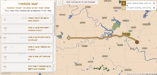
If you've ever wondered how to git yonder then you may be in need of Yondermap. Yondermap is a driving directions service designed exclusively for the use of cowboys & cowgirls (although you can use it as well).

Enter a request for directions into Yondermap and you will receive your riding directions on a Western themed interactive map. The detailed driving instructions provided with your map are also given in the parlance of the old west (e.g. "Giddy up on exit 182").

At the heart of Yondermap is a Mapbox Studio styled custom map and Mapbox Directions. The custom map style uses Western themed fonts, colors and icons. The default step-by-step driving instructions provided with Mapbox Directions (e.g. 'turn left', 'turn right') have been replaced with more appropriate cowboy themed terminology (e.g. 'hang a Louie', 'hang a Ralph').

Yondermap also comes with custom URL's. It is therefore possible to save the link to the map of a particular route or share the link to a set of directions with your friends.


If you prefer your directions given by a pirates then you might prefer Yarr, Pirate Maps. This pirate themed Google Map can provide you driving instructions detailed on a pirate's treasure map.

Yarr, Pirate Maps was one of the earliest maps to make use of custom styles in the Google Maps API. After seven years its nice to see that Yarr, Pirate Maps is still going strong.

A Video Masking Effect


The Wall Street Journal has published an article investigating the protests which have taken place across America since the senseless killing of George Floyd.

The article, Maps: How Protests Evolved in the Wake of George Floyd’s Killing, is illustrated with a cool animated video map of the United States. Every state on this WSJ map is an animated video clip from a Black Lives Matter protest. The effect is very impressive. You need to subscribe to read the article accompanying the map but the map graphic itself can be seen without subscribing. I'm not subscribed to the WSJ so I haven't read the article, but I think the map on its own is worth a visit.

I'm fairly sure I've seen a map before which uses videos shaped as geographical areas. I just can't remember where and when. Both Mapbox and Leaflet have video overlay functions: Mapbox Video on a map and L.VideoOverlay class which allow you to add videos on top of a map. However I'm not sure how you could turn your videos into geographical shapes. It might be possible by using polygon masking (in Mapbox by using the Mapbox mask feature, in Leaflet maps using the leaflet.maskcanvas plug-in and with the Google Maps API using Vasile Cotovanu's polygon masking wizard Geomask).

пятница, июня 12, 2020

The Urban Analysis Interactive Map


Morphocode Explorer is a new interactive tool for urban analysis that allows you to explore thematic maps and key urban indicators directly in the browser. The tool has been designed to help businesses and city planners analyze urban data and gain location insights around land use, development intensity, transit networks and demographics.

The Morphocode Explorer interface consists of an interactive map and a data sidebar. The map is used to define the area which you which wish to explore and the sidebar is used to show the various urban indicators for your searched area. In this sidebar you can explore a number of data layers and view visualizations around local land use, transit and demographics.

By selecting an area on the map you can explore a host of local urban performance measures. This allows developers and city planners to quickly assess locations and view interactive charts and graphs of the data, which will hopefully help them to make more informed decisions.


Morphocode Explorer really does allow you to view a huge range of urban data around local land use, access to public transit, local demographics and other urban performance indicators. Even if you aren't a city planner or urban developer you can use Morphocode Explorer to explore the make-up of your local population, how local land is currently used and your local area's public transit accessibility.

Under the hood Morphocode Explorer uses the Mapbox mapping platform, D3, and a custom data pipeline. You can learn more about how the tool was developed at The Making of Morphocode Explorer.

Taking a Vacation on Google Earth


Google Earth Vacationist is a slideshow of stunning landscapes found on Google Earth. There are already a number of websites which collate some of the most beautiful and interesting satellite views which can be found on Google Maps and Google Earth, however Google Earth Vacationist offers a little more.

Each of the gorgeous satellite views on Google Earth Vacationist can be viewed as both a two dimensional image and as a more abstract extruded picture. I'm not exactly sure how the images are extruded. It doesn't look to me like elevation data has been used. So what you are seeing is more of an artistic impression than a map. Just from looking at a number of the images it looks like height is based on color - with lighter colors being extruded more than darker colors.


Other impressive slideshow presentations of satellite images can be found on Earth View. Google's Earth View application and website is a showcase of some of the most beautiful satellite / aerial views of planet Earth, all of which can be found on Google Maps and Google Earth.

The Earth View showcase includes more than 2,500 of the most beautiful views of our astonishing planet. There are a few ways to explore the aerial images in Earth View. The simplest way is to simply press the play button and sit back and relax as Earth View automatically presents a slideshow of some of Earth's greatest views. Another way to browse Earth View is to select the 'Show Map' option. This allows you to select images by location from an interactive map. This map includes an amazing color filter control which allows you to find landscapes by the view's dominant colors.

How Busy is My Bus?


As more and more people are returning to work more and more people are having to break social distancing protocols by traveling on public transport. What would be really useful for those having to use public transit is real-time information about how many passengers are currently travelling on each bus, tram, train and boat.

Step forward Cardiff Bus. Cardiff Bus' real-time tracking map now includes information about how many people are currently riding on each bus. The Cardiff Bus network uses data gathered from ticket machines and also crowd-sourced from passengers themselves to provide an indication of how many passengers are on each vehicle. Therefore potential passengers can use the live bus tracking map to decide which bus to catch based on the number of passengers on each bus.

While the threat of Covid-19 is still relatively high this is a fantastic feature which other public transit companies should definitely be considering introducing. I know in the UK many trains provide real-time indications on board trains about the passenger numbers in each of the train's carriages. This would be really useful information to also provide online so that potential passengers have more information when deciding to travel or not.

четверг, июня 11, 2020

Virtual Tours of the World's Museums


Beijing's Palace Museum is the world's most popular museum. It is visited by around 15 million people every year. The museum is located in the Forbidden City, which for nearly 500 years was the home of the Chinese Emperor and his household.

The Palace Museum has created a number of virtual tours which allow you to explore some of the museum's galleries and also some of the amazing buildings of the Forbidden City.

Among my favorites of the museum's current 15 virtual tours is a custom Street View tour of the Palace of Longevity and Health. The Palace of Longevity and Health was the home to the widowed consorts of emperors who had died. The widowed wives of late emperors lived in this separate area of the Inner Court of the Forbidden Palace. Being a wife of an Emperor may have come with a whole host of complications but you did get to live surrounded by beautiful opulence.

If you want to explore more of the Forbidden Palace then you might also enjoy the virtual tour of the Garden of Compassion and Tranquility. The Garden of Compassion and Tranquility is one of four gardens in the Forbidden Palace. The Palace of Compassion and Tranquility was another area devoted to empress dowagers (widows of an Emperor).

You can also explore virtual tours on the websites of many other art galleries and museums around the world.

The U.S. National Gallery of Art is temporarily closed but you can still explore some of the gallery's collections and exhibitions of paintings by visiting its virtual exhibitions. Currently the gallery has three virtual exhibitions: Degas at the Opéra Virtual Tour, True to Nature Virtual Tour (European landscapes of the 18th & 19th Centuries) and Raphael and His Circle Virtual Tour.

The Metropolitan Museum of Art - includes a number of virtual exhibitions
The National Gallery - London's National Gallery has a number of virtual tours
The Rijksmuseum Masterpieces Up Close - a virtual tour of the museum's Gallery of Honour
The Sistine Chapel Virtual Tour - explore the Sistine Chapel and Michelangelo's astonishing ceiling
The Smithsonian National Museum of Natural Museum - has created a number of virtual tours
The Stonehenge Virtual Tour - places you in the center of this mysterious pre-historic monument

Louis XIV's Palace of Versailles can be explored in this Google Arts and Culture tour.