понедельник, ноября 30, 2015
Map Your Location Data with Shifted Maps
Shifted Maps is an interesting visualization of personal location data. If you use the Moves mobile application you can use Shifted Maps to view an interactive map of your own location data.
Before testing your own location data you might want to view the demo map to get a feel for how Shifted Maps works. Each location visited in your location data is shown as a zoomed-in circular map inset and the map insets are scaled to show the amount of the time spent there. The size of each circle's circumference line represents the relative number of visits.
You can refine the data shown on the map by date by using the timeline control in the map menu. You can also explore the data by geo-spatial position, travel time, and frequency of movement by using the three icon buttons in the menu. These three buttons rearrange the circular inset maps to provide different visualizations of the location data.
The first button rearranges the map circles to visualize the places visited based on their geographic positions. The middle button provides a temporal view, rearranging the circles according to the average time it takes to travel from one location to another. The third button creates a frequency of movement visualization, places with a frequent connection are shown closer to each other than places with a less frequent connection.
Create Your Own Maps with Map Channels
If you're looking for a quick and easy way to create a Google Map then you should give Maps Channels a whirl.
With Map Channels v5 you can create a free interactive map which you can then embed on your own website or blog. Despite being quick and easy to use version 5 of Maps Channels comes with a lot of interesting options.
You can see what is possible with Map Channels on this user created map of Petra in Jordan. The map includes markers, photos and Street View imagery of some of the important archaeologically sites within Petra. If you click on any of the map markers you can view the location with Google's new panoramic imagery of Petra, with an automatically rotating Street View of the location
Map Channels many interesting features include the ability to create an editable map, add places and select Street Views for your added places. Maps can also be set to allow contributions from visitors. You can easily include road directions on a Maps Channels map, which can also be bookmarked and printed by the map's users.
The Google Maps API recently withdrew the Panoramio photo layer. Map Channels still includes this option so you can also add a Panoramio layer to your map, to show nearby photos from Google's photo sharing website.
Another interesting feature in Map Channels v5 is the option to link to other Map Channels projects directly from your map. For example, you can add markers to your map which then links to a Maps Channels Local Map, Dual Map and/or a Tour Map.
Glasgow Construction Projects in 3D
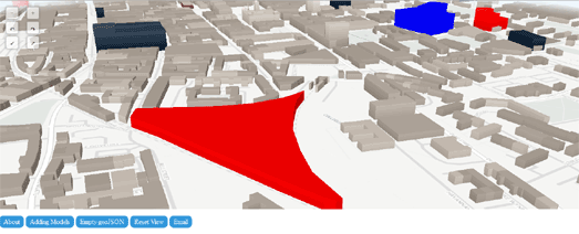
What better way to celebrate St Andrew's Day than with a 3D map of Glasgow. Glasgow in the 21st Century has seen a number of high profile building projects and the city is continuing with a number of ambitious construction projects. You can view Glasgow's current construction plans on this new 3D map of the city.
Lately I've been working a lot with OSM Buidings. In particluar I've been using Webkid's tutorial on creating Interactive 3D Maps With OSMBuildings. The tutorial explains how the Berliner Morgenpost used OSM Buildings to create its excellent Berlin's neue Skyline interactive map of Berlin's new skyscrapers.
Stuart MacMillan has also used Webkid's tutorial to help develop a 3D Map of Glasgow Construction Projects. Stuart's 3D map of Glasgow shows some of the city's current construction plans (highlighted in different colors on the map).
Stuart has added an option for anybody to submit their own GeoJSON building polygons to the map. If you click on the 'Empty GeoJSON' button you will be sent to geojson.io where you can create a building polygon of a Glasgow construction project and then grab the resulting GeoJSON file for the completed building polygon.
воскресенье, ноября 29, 2015
The Geopolitical Maps of the Week
The Oregonian has used CartoDB's Torque library to create an animated map of terrorism deaths around the world from 2001-2014. Deaths by Terrorism, 2001-2014 shows worldwide fatal terrorist attacks by month.
There is always the danger with Torque powered animated maps that the data just becomes flashing dots on a map. On its own the animated data over time on this map probably wouldn't reveal much about international terrorism. However the Oregonian has also added a couple of other data layers to the map to provide some much needed context.
The 'Deaths by Country' option adds a choropleth layer to the map, showing the number of terrorism deaths by country around the world. The 'Narrative' option allows you to select each individual terrorist attacks on the map to view a summary about the attack and the original news source for the data.
123 countries around the world are currently involved in territorial disputes. For example, the USA is currently involved in territorial disputes with Cuba, the Bahamas, Haiti, Colombia, Nicaragua, Jamaica, Honduras, the Marshall Islands and Tokelau.
A World of Disputed Territories is an interactive map of all the territories around the world whose ownership is contested by more than one country. By selecting a country on the map you can view all its current territorial disputes and who those disputes are with.
After you select a country on the map all the country's currently disputed territories are colored yellow on the map and all the other countries involved in the dispute(s) are colored blue. Select one of the disputed territories (colored yellow) and you can read a brief report on the nature of the dispute and the countries involved.
Global Migration Data maps migration patterns around the world on a 3D globe. The map shows the number of migrants to and from each country and which countries they traveled to or from. The data comes from the UN Dept of Economic & Social Affairs for the years 1990, 2000, 2010 and 2013.
Global Migration Data is very easy to use. Simply select a country from the drop-down menu. You can then select to view either inbound or outbound migration for your chosen country. The time-line at the bottom of the map allows you to select which year's migration data you wish to visualize on the globe.
The 3D globe shows the spatial patterns of migration, visualizing which countries around the world migrants traveled to or from for your selected country. The dashboard below the map shows the total number of migrants (inbound or outbound depending on your current choice) and the number of countries migrants are from or the number of countries migrants moved to.
суббота, ноября 28, 2015
Exploring Namibia by Satellite
A Little Landsat Tour is an interesting story map which uses Landsat 8 imagery to explore some of the geological and man-made features which can be found in Namibia.
As you scroll through the tour the map flies across Namibia to highlight a number of geologically interesting locations, such as river valleys, deserts, dry lakes and volcanoes. The tour also explores how man has impacted on the environment, zooming in on diamond mines, ranches, center-pivot irrigated farms and evidence of slash and burn farming.
The map was made by Charlie Loyd, who works on satellite imagery for Mapbox. Judging by the URL I'm guessing that the map was made in 2013 from Landsat imagery captured that same year. The story map format of the tour is based on Mapbox's Scroll Driven Navigation template.
пятница, ноября 27, 2015
Mapping Global Road Fatalities
According to the World Health Organization the USA has poor road safety laws. It fails to meet the WHO's requirements for good drink driving laws, for speed limit laws, for helmet laws and for seat belt and child seat belt laws. This might be why the United States has almost twice as many road fatalities per population as nearly every Western European country.
Death on the Roads is an interactive map showing the number of road deaths and the status of road laws in countries around the world. The map uses data from the WHO Global Status Report on Road Safety 2015 to present a choropleth view of global road deaths and road safety laws.
If you select a country on the map you can view the number of road deaths per 100,000 people. Using the tabs at the top of the map you can also view how well each country meets the WHO's requirements for different road safety laws.
Dublin Story Maps
Storymap Ltd have created two interactive maps of Dublin, in which local people tell their stories about the city and their own lives. Dubline - Storymap presents a route across Dublin, from College Green to Kilmainham. Along & around the route are a number of map markers representing the interesting stories of Dublin and its people.
By clicking on the markers you can watch videos in which Dubliners will regale you with fascinating stories about some of the locations along the route. For example you can hear about Dutch Billy, the most abused statue in Dublin, a gunfight between students and a fellow of Trinity College, and how an elephant came to die on Essex Street.
Storymap is a charming Google Map that captures the personality of Dublin city through Ireland’s age-old tradition of storytelling, presenting a vision of Dublin as told through its stories and storytellers.
If you are ever lucky enough to visit Dublin you can be sure that the locals will talk your ear off. Storymap takes advantage of the Dubliners' love of telling a good tale by presenting the city through the stories of the local people.
The map itself is a collection of videos in which Dubliners tell the stories of locations around the city. The stories include the strange tale of the first cat to fly across the Irish Sea.
The Terrorism Timelapse Map
The Oregonian has used CartoDB's Torque library to create an animated map of terrorism deaths around the world from 2001-2014. Deaths by Terrorism, 2001-2014 shows worldwide fatal terrorist attacks by month.
On its own the animated map layer might have been a little crass, reducing thousands of deaths to little flashing dots on a map. However the Oregonian has also added a couple of other data layers to the map to provide some much needed context.
The 'Deaths by Country' option adds a choropleth layer to the map, showing the number of terrorism deaths by country around the world. The 'Narrative' option allows you to select each individual terrorist attacks on the map to view a summary about the attack and the original news source for the data.
Via: Visualoop
четверг, ноября 26, 2015
The Thanksgiving Flight Map
Update: The animated Google Trends map featured in this post has now been taken down by Google. If you want an alternative you can watch an animated map of the 2022 Pre-Thanksgiving Air Travel Over North America created by the plane tracking website Flight Radar.
Google Trends has published an animated map showing people traveling across the USA to get to their Thanksgiving Day dinners. US Thanksgiving on Google Flights uses CartoDB's Torque library to animate domestic and international air travel on the eve of Thanksgiving booked through Google Flights.
You can use the playback control to navigate through the whole of yesterday's plane journeys. As the day plays out you can see a clear pattern of flights starting on the east coast in the early hours, spreading to the whole country, until the latter hours of the day when flights emanating from the east of the country die down, while flights from the west coast carry on until the early hours of today.
The flight markers on the map are colored to represent the different airlines.
The Battles of Narvik
Germany invaded Norway in April 1940. The northern city of Narvik quickly became an important strategic target for both the Allies and the Nazi. Narvik's ice-free harbour in the North Atlantic provided perfect access by rail to the iron ore mines in Kiruna, Sweden. Both sides were keen to secure this iron supply for themselves and, by doing so, denying it to the enemy.
The Battles of Narvik is a web-documentary commemorating the 75th anniversary of the German invasion of Norway and the battle over the Norwegian town of Narvik. The documentary explores both the land and sea battles between the Nazis and the Allies in their struggle to secure Narvik.
Evidence of the sea battles can still be found deep in the Ofotfjord. On April 10th, 1940 the British Royal Navy and the Kriegsmarine both lost two destroyers each. Three days later the British managed to sink another three German destroyers. Most of these shipwrecks remain at the bottom of the Ofotfjord to this day.
Narvik is a popular destination for scuba divers as it provides a unique opportunity to explore these German and British wrecks from World War II. To help divers locate the wrecks The Battles of Narvik includes a Google Map showing the locations of both the British and German destroyers now lying at the bottom of the Ofotfjord.
You can learn more about the invasion of Norway and the Allies resistance on Invasjonen av Norge. Norway and its allies managed to continue the fight against the German invasion in April 1940 for 62 days. However Germany's invasion of France in May caused Norway's allies to withdraw and the Norwegian government was forced to seek exile in London.
Invasjonen av Norge is a really nicely designed story map recounting the Norwegian War in 1940. The history of the campaign is told in chronological order. As you scroll through the chronology in the map side-panel the map automatically updates to show the relevant location.
Meet the Elephants
Let me introduce you to Pilipili. Pilipili is a member of the Spice family of elephants in Samburu National Reserve in Kenya. Elephant families in the park are given thematic family names and then each member of the family is given a first name on that theme.
Google's latest Street View Trek is a wonderful tour around Samburu National Reserve, Kenya, in which we get to meet the park's elephant families. The tour also explains the work of Save the Elephants, who are working hard to protect and save Africa's elephants.
The tour explains how Save the Elephants monitors elephants on the ground, from the air and via GPS tracking. The organisation also patrols the park, protecting the elephants from poachers and works to rehabilitate injured and orphaned elephants.
You can explore more of the world on Street View with Google's other Street View Treks.
среда, ноября 25, 2015
The Piss & Crap Maps of San Francisco
Apparently people defecating on the streets is a thing in San Francisco. At least it is a big enough problem for Jennifer Wong to think it warrants its own interactive map.
Last year Jennifer used San Francisco Department of Public Works data of sidewalk cleanings for 'human waste or urine' to create the (Human) Wasteland map. The map includes a steaming heat-map view of human waste in San Francisco. This map just might help you avoid wading through human excrement on your next trip around town.
Jennifer made the stylistic choice to color San Francisco's human street waste a fetching shade of crap on her map. The new Piss Map of San Francisco however has gone for a lighter urine shade of yellow.
The Piss Map of San Francisco visualizes the last 2,000 reports of human waste on the streets of San Francisco. That's 164,168 average ounces of urine spayed upon the Streets of San Francisco every year. A line graph of the number of monthly reports of human waste discovered on the city's streets is also overlaid on top of the map.
The Disputed Territories of the World
123 countries around the world are currently involved in territorial disputes. For example, the USA is currently involved in territorial disputes with Cuba, the Bahamas, Haiti, Colombia, Nicaragua, Jamaica, Honduras, the Marshall Islands and Tokelau.
A World of Disputed Territories is an interactive map of all the territories around the world whose ownership is contested by more than one country. By clicking on a country on the map you can view all the territorial disputes it is involved in and who those disputes are with.
After you select a country on the map all the that country's currently disputed territories are colored yellow on the map and all the other countries involved in the dispute(s) are colored blue. Select one of the disputed territories (colored yellow) and you can read a brief report on the nature of the dispute and the countries involved.
Mapping the Icelandic Sagas
The medieval Icelandic family sagas are prose histories describing the lives of the first few generations of settlers in Iceland in the late 9th, 10th, and 11th centuries. The Icelandic Saga Map allows you to read each of the Icelandic Sagas alongside an interactive map showing the locations of all the places mentioned in these historic tales.
When you select an individual saga from the Icelandic Saga Map homepage you are presented with the text of the story alongside an interactive map. Locations in the saga are hyperlinked to the map. Therefore as you read the saga you can select place-names mentioned in the text to view their location on the interactive map. Alternatively you can click on the locations tagged on the map to jump to the parts in the texts where they are mentioned in the Sagas.
When reading an individual saga you can use the Sagas menu (top right) to also overlay the locations mentioned in any of the other Sagas on the interactive map.
вторник, ноября 24, 2015
The Native Tribes of America
Native Land is a Google Map of the territories and languages of the indigenous peoples of the United States and Canada. The map consists of two main layers, one showing the 'territory' of First Nation and Native American tribes and the other showing the geographical spread of indigenous languages.
The 'About' page and 'Teacher's Guide' both provide some fascinating insights into the problems faced in mapping the indigenous peoples of North America. The creator of this map even argues that maps are inherently colonial in nature. However, despite these obvious problems, the Native Land map provides a useful guide to the indigenous people's of the U.S. and Canada and also provides links to great resources on the indigenous tribes and languages.
Natives of North America is another interactive map of the Native American Nations. Obviously one of the biggest problems in mapping Native American territories is that official boundaries between the Nations did not exist and these territories were constantly shifting.
The map overcomes this by creating largely artificial boundaries for the 500 or so native peoples of North America. However the project has been open-sourced in the hope that others will create more fluid maps, which will account for movement over time and for more fluid definitions of the boundaries between the different Native American Nations.
The project's developer also hopes that the Natives of North America map will be improved to include links from each nation to information about the different Native American Nations.
The Invasion of America is a fascinating map of Native American land cession between 1776 and 1887. During this period the United States seized over 1.5 billion acres from the Native Americans.
The map includes a timeline which allows you to view how the United States grew westwards by seizing Native American land through treaties and executive orders. It is possible to search the map by individual Indian Nation. If you click on a tract on the map you can find out the Nation affected and find links to the related treaty and source map overlays.
100 Years of Hong Hong Street Views
HotelClub's Historic Hong Kong allows you to compare the modern bustling streets of Hong Kong with the same streets as they looked 100 years ago. The site uses Google Maps Street View and vintage photos of the city to allow you to show how the city of Hong Kong has changed over the last 100 years.
HotelClub worked with historian Mark Footer to identify some of Hong Kong's most interesting historic streets. The streets used in the site vary from Western Market to the bustling Kennedy Town. Select any of the streets from the main menu and you can a view a vintage photo of the street superimposed on top of the same view today, as captured by Google Maps Street View.
User Tip - If you are viewing Historic Hong Kong on a desktop then shrink your browser down a little. If you do this a swipe button will appear that allows you to swipe back and forth between the vintage photo and the modern day Street View. If you view Historic Hong Kong on a mobile device the swipe button will appear on all the photos anyway.
Mapping Global Migration Data
Global Migration Data maps migration patterns around the world on a 3D globe. The map shows the number of migrants to and from each country and which countries they traveled to or from. The data comes from the UN Dept of Economic & Social Affairs for the years 1990, 2000, 2010 and 2013.
Global Migration Data is very easy to use. Simply select a country from the drop-down menu. You can then select to view either inbound or outbound migration for your chosen country. The time-line at the bottom of the map allows you to select which year's migration data you wish to visualize on the globe.
The 3D globe shows the spatial patterns of migration, visualizing which countries around the world migrants traveled to or from for your selected country. The dashboard below the map shows the total number of migrants (inbound or outbound depending on your current choice) and the number of countries migrants are from or the number of countries migrants moved to.
понедельник, ноября 23, 2015
The 3D Historical Map of New York
Old School New York is an historical 3D map of a few blocks of Lower East Side in New York City. The building footprint data for this map comes from the New York Public Library's Building Inspector API. The NYPL's Building Inspector tool is being used to extract, correct and analyze data from historical maps of New York.
The building footprints from this crowd-sourced effort are available from the API. The building footprints on this Old School New York map come from sheet numbers 174, 176, 177, 178 and 179.
The building footprints from the NYPL's Building Inspector API are returned in the GeoJSON format. This means it is a simple task to add the footprints to OSM Buidings. However the building footprint data from Building Inspector does not have any height data attached. Therefore for this map I made all the buildings 12 meters high. This is a wild guess on my part and almost definitely inaccurate.
In order to make the map I used Webkid's brilliant tutorial, Interactive 3D Maps With OSMBuildings. I also stole most of his code.
In summary - this 3D map has inaccurate building heights. The date for the map is also unknown. However, these major quibbles aside, I think the map does demonstrate how the NYPL's Building Inspector data can be used to make 3D maps of New York from the library's historical maps.
The Guided Petra Street View Tour
Google today released new Street View on Google Maps from a number of historic sites in Jordan.
The new imagery includes Street Views from Jerash and Mount Nebo. However the biggest news has to be the amazing imagery from Petra,
The best way to view Google's new Street View imagery from Petra is to visit Google's new Explore Petra with Street View website. This new website takes you on a tour of Petra using Street View and an audio guide. Follow the links on the tour map or use the arrow keys in the Street View imagery to explore Petra's amazing sights.
On the tour you can visit the world famous Treasury, the Monastery, theatre and many temples. As you explore Petra the audio guide will provide information about the various sights on your tour. Street View overlays also provide extra information on Petra's history and the various locations on the tour.
The Wind Farm Map
The United Kingdom generates a higher percentage of its electricity from offshore wind farms than any other country. You can view the current output of the UK's offshore wind farms on this Offshore Wind Electricity Map.
The map shows the locations of the UK's offshore wind farms. Each wind farm is represented on the map by a scaled animated wind turbine marker. The size of the marker represents the scale of the current output from each wind farm. If you select a marker on the map you can view the name of the wind farm and its current output in megawatts.
The map sidebar shows a dashboard reading of the share of the UK's electricity currently being generated by offshore wind. If you select a marker on the map the dashboard updates to show the operator of the selected wind farm, the site capacity, the number of turbines and the type of turbines.
воскресенье, ноября 22, 2015
The Mapnificent Maps of the Week
Real-time transit maps are kind of old news these days. However that didn't stop VBB-Livekarte becoming by far and away the most read post on Maps Mania this week.
VBB-Livekarte is an interactive map showing the real-time position of buses, trams and trains in Berlin. Although the concept might not be knew I think part of the success of VBB-Livekarte is due to its huge scale. The map shows around 1,000 rail lines & bus routes and more than 13,000 stops & stations on the VBB network, Using the map you can watch all the long-distance & regional trains, commuter trains, subway trains, trams, buses and ferries moving around Berlin in real-time.
Line of Sight was another very popular interactive map this week which seemed to cover some familiar ground. There are already a number of maps which allow you to track the real-time position of satellites orbiting the Earth. However the futuristic design of Line of Sight seems to have a struck a popular chord.
Enter your location into Line of Sight and you can view the current live position of satellites and their orbital tracks. Therefore you can use the map to find out which satellites might be passing overhead and then go outside and try to find them in the night sky.
There are now fewer than 60 Amur leopards living in the wild. Part of the reason for this is the loss of the leopard's natural habitat. Leopards have lost around 66% of their natural habitat in Africa and 85% in Eurasia. This loss of habitat and the effect on Leopards is explored in National Geographic's Learning to Live with Leopards.
National Geographic's report examines the relationship between man and leopard and the effect of the rising human population on the survival of this majestic animal. The report is accompanied by an interactive map which shows the leopard's historic range (from circa 1750) and its range today.
The map looks in turn at each of the subspecies of leopards (African, Arabian, Persian, Indian, Sri Lankan, Indochinese, Javan, North Chinese and Amur). When you select one of the subspecies the map zooms in on that species' natural habitat. The map shows the historical range and the current range of the selected subspecies of leopard, alongside the density of the human population. The map sidebar also reports on the estimated numbers left of each subspecies of leopard.
суббота, ноября 21, 2015
Winter Arrives with the #uksnow Map
This morning people in the UK woke up to discover that the #uksnow Map had turned white overnight. The #uksnow Map shows that winter has finally arrived, at least it has in the north east of the country.
The #ukSnow Map shows the latest Twitter activity mentioning snow in the UK. If you want your Tweet to appear on the map use the hashtag #uksnow, give your location (by Tweeting the first half of your postcode or by geotagging your Tweet) and rate the snow (0/10 is nothing - 10/10 is a blizzard).
пятница, ноября 20, 2015
150 Years of Hurricanes
NOAA's Historical Hurricane Tracks map allows you to view global hurricane data back as far as 1842. Using the map you can search and visualize hurricane data by storm name, location and by date.
If you enter the name of a hurricane (for example 2012's Hurricane Sandy) you can view the hurricane's track on the map. Points along the hurricane's track allow you to view details about the wind speed and pressure for each day. A link is also provided to read a PDF of NOAA's storm report.
If you select the 'County Strikes' option from the map menu you can view a choropleth map of U.S. coastal counties. The counties colored dark red have historically had more hurricane strikes than the counties colored with a lighter red.
Tornado Tracks, 1950-2014 also allows you to view historical tornado data on an interactive map. This map visualizes the path of every tornado in the United States since the middle of the Twentieth Century..
You can filter the tornadoes shown on the map by scale, by year range and by the number of casualties caused. You can also select an individual tornado track on the map to view its strength, date, length & width and the number of injuries & fatalities.
Spinal Map
Thunderforest, designers of some of the world's most popular interactive map styles, has released a totally new map tiles style. Thuderforest is probably best know for its OpenCycleMap map style. It also hosts a number of other popular interactive styled map tiles, including Transport, Landscape, Outdoors and Transport Dark.
Thuderforest's new style is a little different. Spinal Map is a heavy rock inspired map style. It comes complete with a Gothic font and rivers & seas of fire. The font makes heavy use of metal umlauts. Place names on the map that include the word 'City' have also become 'City of Rock'.
Fans of rock might also like Mapbox's Wheatpaste map style. Wheatpaste is a map style inspired by the cut & paste, collage style of music flyers & posters, popular with punk and new wave bands.
If you want to explore some more interesting styled maps then you check out this Map Styles Gallery map.
четверг, ноября 19, 2015
Volkswagen Pollution in California
There are around 193,000 Volkswagen diesel cars in California. These cars are reported to emit more than 40 times the authorized amounts of NOx and particulate matter. Non-Compliant VW Diesels in California is an interactive map showing the number of non-compliant Volkswagen cars and the pollution index in each Californian zip-code area.
If you select one of the zip-code districts (outlined in white) on the map you can view the top 5 commuter routes from the area. You can also use the map menu to view the Pollution and Poverty Index overlaid on the map and to view the locations of EV and EvGo chargers.
If you select a district from the top bar you can view the total number of non-compliant diesel cars in the district and the expected annual cost for asthma in the district.
New York Takes to the Skies Again
Berlin is not the only city whose skyline is being constantly punctured by the pinnacles of newly constructed skyscrapers. In New York 15 buildings over 700 feet are currently being constructed - 19 more are in the pipeline.
National Geographic has created a plan view of New York's skyline showing how it will look when all these new skyscrapers have been built. The New York City Skyline shows the view of New York, looking from the direction of Brooklyn. As you scroll down the page the plan of the city skyline moves, giving you a panoramic view of the city from Lower to Midtown Manhattan.
Skyscrapers under construction are shown in orange on the panoramic image and proposed skyscrapers are colored yellow, You can mouse-over any of the colored skyscrapers to view its name and its completed height.
среда, ноября 18, 2015
OpenSnowMap
If you've started hunting around for a good place to go skiing this winter then you might want to have a look at OpenSnowMap. OpenSnowMap provides the latest snow cover alongside ski trail and ski lift maps.
When you are zoomed out on the map you can see the last eight days Modis snow cover around the world. Zoom in on a ski resort and you can view all the ski runs, colored by difficulty and the locations of ski-lifts and ski-chairs.
The base map layer includes relief hill-shading and contour lines. If you select the 'list' option you can view all the pistes in the current map bounds. You can then select individual runs on the map to view an elevation profile of the selected run and its length. OpenSnowMap also includes the handy option to print out the map from a PDF file of the current map view.
Hat-tip: Mapperz
Interactive Map of Mercury
Messenger and the Science of Mercury is an Esri story map showcasing some of the discoveries made by the Messenger's spacecraft's orbit of the closest planet to the sun. Messenger was the first spacecraft to ever orbit Mercury and its findings have greatly enhanced our understanding of the planet.
Messenger and the Science of Mercury contains imagery of Mercury captured by Messenger during its orbit. It also includes an interactive map of the planet created by the Messenger team in 2013. The main part of the story map however is made up of a series of images with accompanying explanations examining the topography, mineralogy and atmosphere of Mercury.
The Real-Time Berlin Transit Map
You can now watch all Berlin's buses and trains moving in real-time on an interactive map. VBB-Livekarte is an interactive map showing the real-time position of buses and trains in Berlin.
The map shows around 1,000 rail lines & bus routes and more than 13,000 stops & stations on the VBB network, Using the map you can watch all the long-distance & regional trains, commuter trains, subway trains, trams, buses and ferries moving around Berlin in real-time.
VBB-Livekarte does not use GPS data from buses and trains to plot their positions on the map. The position of the vehicles on VBB-Livekarte are estimated based on the live schedule where available and the planned timetable where no live data is available. This means that the positions of the buses and trains on the map are not always accurate. However, where live schedules are available, the vehicle positions should be fairly accurate.
вторник, ноября 17, 2015
Map My Day
Wheelmap,org is a crowd-sourced interactive map which shows the location of wheelchair-accessible venues around the world. Because Wheelmap.org is a community project it relies on the help of users to help collect information on wheelchair-accessible locations.
Sozialhelden e.V. and the World Health Organisation want you to help Wheelmap.org on December 3rd, the International Day of Persons with Disabilities. As part of their MapMyDay campaign they want you to use Wheelmap.org to map all the public places you visit on December 3rd. Using the Wheelmap.org website or the Wheelmap.org mobile applications they want you to simply choose whether the places you visit on December 3rd are ‘fully’, ‘partially’ or ‘not wheelchair accessible’.
You can learn more about MapMyDay and how you can take part on the MapMyDay website. The site features an interesting interactive map which allows you to discover more about the campaign, how you can participate and how you can help promote the day of action.
Live Satellite Tracking
Look up at the night sky tonight and see how many satellites you can find. If you have any problems spotting the satellites passing overhead then you can always use Line of Sight.
Line of Sight is an interactive map which shows the overhead position of satellites orbiting the Earth. Just enter your location into the map and you can view the current live position of satellites and their orbital tracks. You can mouse-over individual satellites or their tracks on the map to find out the satellite's name, it's status, height and where you need to look to be able to see it in the night sky.
Line of Sight includes a number of options to refine the types of satellite shown on the map. If you are satellite spotting yourself then you should choose the 'visible' satellites option. However you can also select to view the positions of navigation satellites, military satellites and lots of other types of satellites from the 'Types' menu.
понедельник, ноября 16, 2015
Mapping the Leopards
There are now fewer than 60 Amur leopards living in the wild. Part of the reason for this is the loss of the leopard's natural habitat. Leopards have lost around 66% of their natural habitat in Africa and 85% in Eurasia. This loss of habitat and the effect on Leopards is explored in National Geographic's Learning to Live with Leopards.
National Geographic's report examines the relationship between man and leopard and the effect of the rising human population on the survival of this majestic animal. The report is accompanied by an interactive map which shows the leopard's historic range (in circa 1750) and its range today.
The map looks in turn at each of the subspecies of leopards (African, Arabian, Persian, Indian, Sri Lankan, Indochinese, Javan, North Chinese and Amur). When you select one of the subspecies the map zooms in on that species' natural habitat. The map shows the historical range and the current range of the selected subspecies of leopard, alongside the density of the human population. The map sidebar also reports on the estimated numbers left of each subspecies of leopard.
Via: Visualoop
The Toxic Brooklyn Map
Neighbors Allied for Good Growth (NAG) is a North Brooklyn based group working to recapture the Greenpoint and Williamsburg waterfront and reduce local environmental hazard. As part of this mission NAG has created an interactive map of toxic hot spots in Greenpoint and Williamsburg.
The ToxiCity Map highlights potentially polluted sites in North Brooklyn while also providing data layers on neighborhood characteristics, such as population density and asthma hospital visits in the area. The data is organized into three main categories: environmental risks, neighborhood characteristics and industrial history.
The environmental risks category contains three data layers: potentially polluted sites, future flood risk and waste transfer stations. Any of these data layers can be combined with the neighborhood characteristics data. So, for example, you can overlay the population density layer on top of the potentially polluted sites to see how many people are living in potentially polluted areas.
The Sounds of Street View
Jumper is a collection of some of the best Street View images that can be found on Google Maps. Jumper actually has only a very small collection of eleven selected Street Views. Therefore Jumper isn't going to compete with the many other Street View collecting websites based on its size.
However Jumper does have its own unique selling point - sound. Each Street View on Jumper is accompanied by an appropriate audio backing track. View Times Square on Jumper and you'll hear traffic and people walking. A visit to the White House on Jumper is accompanied by the sound of the American national anthem. Dive down to look at the Great Barrier Reef on Street View and you can hear the sound of air bubbles escaping from your breathing apparatus.
Jumper isn't the only website to have the idea of combining Google Maps Street View with sound. Amplifon's Sounds of Street View, is a development platform which allows you to add sound to Google Maps Street View. If you visit Sounds of Street View's Create Your Own platform you can download the Sounds of Street View framework and read a detailed guide explaining how to create your own Street View sound experience.
Zombie Sound Experienz has used the Sounds of Street View with the Business Photos Street View tour from the Zombie Manor in Drayton to create a creepy virtual tour, with full 3d sound. As you progress through this zombie filled virtual Street View tour you can actually hear the zombies pursuing you.
As you visit the different rooms in the Zombie Manor you will hear a
variety of creepy sounds. Different zombies and rooms have different
sounds attached to them, which get louder or quieter as you approach or
travel away from the waiting walking dead.
The combination of 360 degree panoramas with recorded sound really does help to create a more immersive experience providing an experience of both the audio and visual ambiance of locations around the world.
The Sound City Project has created a very impressive visual & aural experience using their own interactive panoramas and combining these with high quality 3D sound recordings. Using the application you can explore locations, such as Times Square in New York and the Palace of Fine Arts in San Francisco, with custom Street View imagery while listening to the sounds recorded at the same locations.
A styled Google Map allows you to navigate between the different locations featured in the project, including a number of locations in New York, San Francisco and also in Sweden & Norway.
Pregoneros de Medellín is a wonderfully immersive virtual journey around the colorful streets of Medellín in Colombia. The experience is vaguely similar to exploring locations with Google Maps Street View - only with sound, smoother transitions and lots more interactivity.
Pregoneros de Medellín was not created with panoramic images but with video. However this isn't video as you normally know it. To progress through the video you need to scroll down on the web page. As you scroll you move through the stills of the video.
While you stroll around Medellin you can listen to the sounds of the streets and the street vendors. You can also interact with some of the characters you find on your journey. The interactive characters are indicated on screen with map markers positioned above their heads. Click on the markers and you can view short documentary type videos about the selected individual's lives.
Another truly amazing documentary type tour of an individual city has been created by Google themselves, Google Night Walk is an amazing narrated Street View tour of Marseilles at night.
Google Night Walk takes you on an immersive journey through the lively Cours Julien neighbourhood of Marseille. The tour includes an audio narrated guide by Julie and Christophe, two urban storytellers, who help explain the living history of the city.
Many of the custom Street View panoramas in the tour are also enhanced
by sound experiences recorded at the same time as the panoramas.
воскресенье, ноября 15, 2015
Maps of the Week
Mapillary, the crowd-sourced alternative to Street View, has added the option to view a 3D point cloud model for every location in the world - where Mapillary imagery exists. The point cloud models are built from all the photos submitted to Mapillary around a selected location.
You can read more about the new 3D point cloud model option on the Mapillary blog. However, if you want to dive straight in, go to Mapillary, click on the map and open a photo. When you view a photo in Mapillary you can now select the 'Show point cloud' to view the 3D model. You can zoom in and out in the model using your mouse-wheel. Press shift and drag on the model to orbit around the 3D point cloud.
Windyty, the animated weather map, is now an animated 3D globe. Windyty shows current and forecast weather conditions across the world.
By default Windyty now displays its animated weather layers on a 3D globe. If you prefer the mapped version you can click on the gear icon and turn off the 3D mode in the settings. The settings menu also allows you to change the temperature from Centigrade to Fahrenheit and to change the background map layer.
The onscreen menu allows you to adjust the weather layer that is animated on the map. These options include wind, temperature, clouds, waves, snow and pressure.
Mapping Ten Years of Fatal Traffic Accidents is an interactive map showing every single fatal traffic accident in the United States from 2004 to 2013.
When zoomed out the map presents a heatmap view showing the locations where the most fatal traffic accidents have occurred. When you zoom in map markers appear showing the location of each individual fatal accident. This means that you can zoom on any city or town in the USA to view a detailed map of where accidents occurred locally.
When you zoom in on the map option controls also appear which allow you to filter the accidents shown by contributing factors (alcohol, speeding and driver distraction). The markers are also colored on the map to show who was killed in each accident (driver, passenger, pedestrian etc).
Подписаться на:
Сообщения (Atom)