вторник, января 31, 2023

Iceland's Shrinking Glaciers

The map above shows the size of the Langjökull and Hofsjökull glaciers at the end of the 19th Century (yellow line) and in 2019 (red line). Glaciers in Iceland have in total shrunk by more than 2200 km² since the end of the 19th century. You can explore the extent to which each glacier has changed in size for yourself on the Icelandic Glacier Web Portal.

The Icelandic Glacier Web Portal displays measurements of Icelandic glaciers taken since 1890. The maps are based on a number of different sources. The Icelandic Glaciological Society have carried out measurements of the country's glaciers since the 1950's. Other institutions such as the Institute of Earth Sciences at the University of Iceland and the Icelandic Meteorological Office also carry out regular measurements of glacier mass and termini.

Using the portal's interactive map it is possible to view outlines of the extent of each of Iceland's glaciers at different dates from 1890-2019. In this way it is possible to explore how each glacier has changed in size over time. The interactive map on the portal uses the Leaflet.js mapping platform. As well as the glacier extents layer the map includes layers which show terminus measurements and historical photographs. All these layers are available as both #WMS and #WFS map tiles and can be used under a CC-BY 4.0 licence.

You can explore other powerful interactive visualizations of glacial melt in the Maps Mania post Melting Glaciers.

воскресенье, января 29, 2023

The Distribution of Surnames

The superbly named Namensverbreitungskarte is an interactive map which can show the distribution of surnames in Germany. Enter a family name into the map and you can see where people with that name lived in 1996 and in 1890. The distribution is based on German casualty lists of the 1st World War and the German phone directory from 1996.

One neat feature of Namensverbreitngskarte is that you can visualize more than one name at once. Search for a new name and its distribution will be added to the map using a different color. For example the map above shows the 1880 distribution of the names Kruse, Kraus and Krause. The Benrath Line (a line which roughly divides German northern and southern dialects) can be seen in the distribution of the name's variations across Germany. If you click on the 'About Name distribution map' link you can view a few more interesting examples of the distribution of various German surnames. 
 

The German Surname Map is another fascinating tool for visualizing the geographical distribution of surnames in Germany. Enter a surname into the tool and you can view a map showing where people with that name are distributed throughout the country. 

If you enter the name Merkel into the map (the name of the ex-German Chancellor) you will discover that it is a common surname in Germany, with quite an even distribution throughout the country. Angela Merkle was born in Hamburg. There appear to be quite a few Merkles in Hamburg, although the biggest concentration of the surname appears to be in some of the southern states.

In Germany you can also use GeoGen to view the geographical distribution of German surnames. The use of three dimensional stacks on this map helps to make it a little more clear where a particular surname has its highest concentration in the country.

Searching Merkel on GeoGen and the German Surname Map seems to suggest that the highest concentration of Merkels in Germany can be found in Baden-Baden. However as neither map uses place-name labels it isn't always easy to determine individual towns on either map (the highest concentration of Merkels may therefore be in one of Baden-Baden's closest neighboring towns). 

If you want to research the geographical distribution of surnames in other countries then you can use:

You can also explore the global distribution of your family name using Forebears. You can use Forebears to undertake a global search for your surname. If you enter a surname into Forebears it will tell you both the meaning of your name and show you a map of the global distribution of your name. Beneath this generated map you can view a list showing the number of incidences of your surname recorded in each country around the world. It also shows the ratio of people with your surname in each country and the rank of your name in comparison to the incidence of all over surnames in each country.

The 2023 Czech Presidential Election Maps

The pro-western retired general Petr Pavel has swept to victory in the 2023 Czech Presidential Election. In yesterday's election he convincingly beat the ex-Prime Minister Andrej Babiš.

Czech newspaper Blesk has used the Leaflet mapping library to create an interactive election map of the 2023 Presidential Election. The map colors each region to show the presidential candidate who received the most votes. If you click on these regions you can view the exact percentage and number of votes cast for each candidate. If you zoom in on the map you can also view the results in each electoral district.

Dnes has also released an interactive map of the 2023 Presidential Election. The Dnes map colors each electoral constituency to show the winning candidate. You can hover over a consituency to see the percentage of votes won by the winning candidate and you can click through to view the percentage of votes cast for each candidate in every town in the constituency. 

Denik has created its own similar map which colors each region to show the winning candidate. Hover over a region and you can view the percentage of the votes won by the leading candidate. If you click on a region on the map you can also view a map of the results in each district in the selected region.

суббота, января 28, 2023

Natural Gas Flaring Map

The SkyTruth Flaring Map visualizes daily infrared detections of oil wells around the world burning off excess gas. Flaring from natural oil wells is a huge contributor to global heating. For example in 2018 145 billion cubic meters of natural gas was burned during flaring. That is the equivalent of the entire gas consumption of Central and South America combined.

The SkyTruth Flaring Map uses data detected by NOAA’s Suomi NPP satellite. The map is updated daily to show all infrared detections hot enough to be gas flares. The map animates through these nightly detections of global flaring. The animation can be controlled using the timeline tool in the map sidebar.

SkyTruth has also released an Annual Flaring Volume Map. This map shows the annual volume estimates of gas flaring maintained by the Earth Observation Group.

On this map oil refineries around the world are shown using a red marker. You can click on the individual markers to view the estimated volume of gas flared and the detection frequency. The map includes drawing tools which allow you to create your own areas of interest on the map to view (and download) the flaring data for only the refineries in your defined area.

пятница, января 27, 2023

Asteroid Watch

Yesterday an asteroid the size of a minibus narrowly passed by the Earth. Asteroid 2023 BU actually missed the Earth by 2,200 miles, but was so close that it passed inside the arc of our orbiting telecommunications satellites (orbiting around 22,000 miles).

Thanks to NASA's Eyes on Asteroids you can take a closer look at 2023 BU and even replay its close pass-by of Earth. NASA’s 3D interactive celestial map plots the locations of comets and asteroids in real-time. The map tracks the orbits of every known near-Earth object (currently around 28,000 objects).

If you enter the name 2023 BU into the Eyes on Asteroid search box you can view a 3D model of the asteroid. Using the slide control at the bottom of the map you can then move back and forward in time to view the asteroid's orbital motion (and replay its close fly-by of Earth). 

The asteroid was only discovered last Saturday, by a Crimean amateur astronomer named Gennady Borisov. Even if 2023 BU's orbit had led to a collision with Earth it is unlikely that it would have done much damage, Because of its size BU 2023 would most likely have been destroyed high in Earth's atmosphere. Small pieces of the asteroid may have fallen to Earth as meteorites.

среда, января 25, 2023

The Global Contrail Map

Global air travel is a significant contributor to climate change. A recent study revealed that aircraft contrails contribute over half of the sector's global warming impact. The study shows how contrails (the icy clouds that form in the wake of aircraft) effectively trap heat in the atmosphere, heat which would otherwise be released into space.

The Contrail Climate Initiative's Contrail Map explains how contrails are formed, how they contribute to global heating and how flights can be diverted to avoid forming contrails by adjusting the plane's altitude. Contrails are formed when there are low temperatures and high humidity. If these atmospheric conditions persist then the contrails also persist and act as heat traps.

The interactive Contrail Map visualizes contrails around the world on one day in 2022 (8pm Jan 21 - 8pm Jan 22). On the map warming contrails are shown in red and cooling contrails are shown in blue. The moving white lines are the flight trajectories of planes flying around the world. 

Luckily it is possible to significantly reduce the number of contrails produced by global air traffic. The Contrail Map explains how specific atmospheric conditions help form contrails and how weather forecasts can predict where these conditions are likely to appear. Airlines can therefore use weather forecasts to adjust their flight plans to avoid areas with atmospheric conditions conducive to the formation of contrails. 

Often this is as easy as making small changes to a plane's altitude. The Contrail Map guide animates an example flight showing how by applying a small change to the plane's altitude it could avoid all the 'potential contrail regions'.  

вторник, января 24, 2023

Mapping the Ocean Deep

On 21 December 1872 HMS Challenger set sail from Portsmouth on a four-year scientific expedition to map the ocean floor, to measure ocean temperatures and to document marine life. It was the first global marine research expedition. A four-year expedition which managed to discover 4,700 new species, record hundreds of sea soundings (in the process verifying the existence of the Mid-Atlantic Ridge), and make 263 water temperature observations.

The University of Illinois' Challenger Expedition portal allows you to explore an interactive map of the HMS Challenger's marine research voyage.  Using the map you can follow the route taken by the ship on its four year voyage and explore some of the data recorded in the 50 volumes of the voyage's logs. 

If you click on Station 1 (just west of Spain and Portugal on the map) you can start at the beginning of the ship's voyage (1872-12-30). You can then use the forward arrows to follow the voyage chronologically. The information window on the map provides details of the discoveries made at each station. It shows you the date of the observations made at this location, the recorded ocean depth, the surface and bottom temperatures, and the detected species at that location. 

If you navigate to Station 225 on the map you can explore the results of HMS Challenger's findings at Challenger Deep (a depression now named after the Royal Naval ship). On 23 March 1875 the ship recorded a depth of 4,475 fathoms. The expedition had (unknowingly) found the deepest point on the Earth's seabed in the Mariana Trench.

Challenger Deep is deep. Very Deep. Located in the Mariana Trench, Challenger Deep is the deepest known point in the Earth's seabed. But just How Deep is Challenger Deep?

John Nelson has the answer in his beautiful Esri story map. This map helps to explain the staggering depths first discovered by HMS Challenger. As you progress through this story map you will learn about the natural forces which created this huge depression deep beneath the Pacific Ocean. You will also learn about the kind of dark inhospitable conditions which exist at so many fathoms beneath the sea.

To help convey the staggering depth of Challenger Deep the map uses a number of non-standardized units of measurement. This involves showing how many Everests, Manhattans or Grand Canyons deep the depression falls beneath the surface of the sea. To help illustrate these non-standardized units of measurement Nelson has stacked a number of Mount Everests one on top of the other and relocated the Burj Khalifa to the bottom of the Grand Canyon. All for a sense of scale - of course.

понедельник, января 23, 2023

The Open Etymology Map(s)

Back in 2013 I saw Noah Veltman introducing his History of San Francisco Place Names map at Geomob. Noah's map explains the meaning of San Francisco street names. Click on a street on the map and you can learn who or what that street is named for. 

Ever since the release of the History of San Francisco Place Names I've become fascinated by toponyms and the etymology of street names. If you are also interested in knowing the meanings behind the street names in your town or city then a good place to start is two maps, both of which are confusingly called the Open Etymology Map. 

In 2021 Daniele Santini released his Open Etymology Map, a global map which explains the origins of individual street names around the world based on information taken from OpenStreetMap and Wikidata. MapComplete has also released their own Open Etymology Map. If you click on a highlighted street or location on either of these two maps you can view a Wikipedia article related to the street's etymology.

Both these Open Etymology Maps have the same problem. Using data from OpenStreetMap and Wikidata has its advantages and disadvantages. One of the disadvantages is Wikidata has far more information about the origins of street names in some cities (e.g. San Francisco) than it does in other cities (e.g. London). The advantage is that you can actually improve the map in your town or city yourself by adding etymological data to Wikidata. Once Wikidata has the etymological information about a location then that same information should start appearing on both the Open Etymolgy Maps.

суббота, января 21, 2023

Forever Chemicals in Freshwater Fish

A new study by the Environmental Working Group (EWG) has found harmful levels of PFAS in freshwater fish throughout the United States. The study measured the harmful levels of 'forever chemicals' in freshwater fish collected across the United States. 

PFAS are known as 'forever chemicals'  because they never break down in the environment. They have entered freshwater bodies across the United States because industrial discharges of PFAS, from manufacturing facilities, municipal landfills & wastewater treatment plants, airports, and firefighting foams are routinely discharged into groundwater. 

Even very low doses of PFAS in drinking water can suppress the human immune system and can increase the risk of certain cancers. The new EWG study has found that eating one contaminated freshwater fish could equal a month of drinking PFAS contaminated water. 

You can view the results of the EWG study on a new Forever Chemicals in Freshwater Fish interactive map. The map allows you to discover the levels of PFAS contaminations found at over 500 freshwater sites across the United States. Click on one of the sampled sites on the map and you can view its exact location, the fish species sampled (and the date of the sample) and the levels of the various PFAS detected in the fish.

пятница, января 20, 2023

Mapping the Snow, Wind & Rain

Billboard Particles is a 3D map which includes an animated snow storm. The map animates white circles on top of a 3D map in order to simulate the look of an actual snowfall. 

The Billboard Particles demo uses the Mapbox GL library but the billboard technique used could essentially be adapted and applied to any interactive mapping platform. If you prefer to use Leaflet then you might want to explore Grigory Golikov's Leaflet.Snow plug-in. The plug-in allows you to add an animated snow layer to a Leaflet map. Leaflet.Snow can animate snow flakes on top of your map, with options to adjust the speed, density, size and color of the flakes.

Grigory is also the author of Leaflet.Rain, a plug-in for the Leaflet JavaScript mapping library which allows you to add a rain animation to your interactive maps. If you want to add an animated wind layer to your map then you can use the Windy Leaflet Plug-in. This uses the Windy API to add an animated global wind forecast to a Leaflet map.

While we are on the subject of mapping the weather you might also like this Snowfall Map. William Davis's interactive map Snowfall is a fantastic visualization of snowfall in the United States over this winter. As you scroll through this map you can watch a visualization of 6-hour snowfall accumulation across the country from October 13 to December 18, 2022.

четверг, января 19, 2023

Explore Your Neighborhood Profile

The UK's Office for National Statistics has released a fantastic new tool which allows you to explore the results of the 2021 census for any custom area in England and Wales. This means that you can explore the demographics of your local neighborhood simply by drawing its outline on an interactive map.

Build a custom area profile allows you to select an area by name or postcode. It also allows you to draw your own custom area on top of an interactive map. Once you have defined your area the tool displays the number of people living there based on the 2021 census. If you click on the 'Build Profile' link you can then explore other data gathered from the census.

Select 'Age Profile' and you can view a breakdown of the age groups in your selected area. Select 'Ethnic Group' and you can explore the percentage of different ethnicities in your area. In total there are 31 different census topics which you can explore, including data related to housing, work, and education.

You can also explore the 2021 census results for your area on the Census Maps tool. This tool allows you to explore the same census data. However this map only shows the data for predefined census output areas and doesn't allow you to draw your own areas of interest. 

среда, января 18, 2023

Build a Wind Turbine in Your Garden

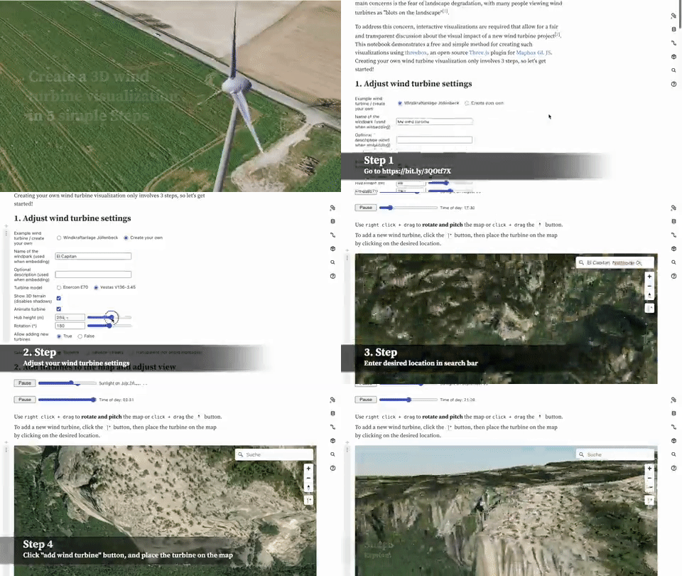
Visualizing wind turbines in 3D is an interactive map which can help you visualize the visual impact of erecting wind turbines at any location on Earth. 

Despite wind energy being a clean and relatively cheap source of energy the construction of new turbines can sometimes meet local resistance. People are often opposed to the erection of new turbines because of the visual impact of turbines on the local landscape. 'Visualizing wind turbines in 3D' allows you to model the visual impact of new wind turbines (of any height) by allowing you to add a 3D model of planned new turbines to a 3D map.

Using the map you can choose between two different types of turbine model (Enercon E70 or Vestas V136-3.45). You can also adjust the height of the wind turbines you want to add to the map. You can then add the 3D model of your wind turbine to any location simply by selecting the add turbine button and clicking on the map.

The map was created using three.js and Mapbox. If you want to experiment with adding your own 3D models to an interactive map then the Add a 3D Model example in the Mapbox GL development docs is a good place to start. 

вторник, января 17, 2023

Californian Coastal Erosion

This month California has been hit by a series of atmospheric rivers. When atmospheric rivers move over land they can result in heavy and rapid rainfall. As a result of these atmospheric rivers during the first two weeks of January nearly all of California has been affected by rainfall totals from 400-600% above average values for this time of year.

The USGS has been collecting topographic data in order to examine the erosion effect of the January 2023 storms on the coastline of Santa Cruz, California. Using aerial photographs captured on January 5th, 2023 the USGS has been able to create photogrammetry data that can be used to visualize elevation change to the Santa Cruz coastline.

You can view the data on this 3D Data Viewer interactive map. On this map the point cloud data is colored to show elevation change The red areas have seen erosion and the blue areas have seen accretion. The USGS has also compiled a number of before & after visualizations of the data which compare the  coastline now to the coastline as it looked before Sept. 13, 2022. These visualizations can be viewed in the article USGS Remote Sensing Data Tracks Coastal Erosion from California Storms.

понедельник, января 16, 2023

A Dialect Map of England

The University of Leeds' Dialect and Heritage Project has released a Sound Map of English dialects. The map features archived audio recordings of native English speakers from the different regions of England. 

In the 1950s and 1960s the Survey of English Dialects undertook to complete a survey of the regional dialects of England. The survey was conducted in over 300 different towns and villages. In each location a local person was asked about the words they used for everyday objects and about their local customs, culture and way of life. The survey included a questionnaire of over 1,300 questions and the surveyors used a special notation to record accents and pronounciation differences.

As the survey progressed the surveyors also began to use recording equipment in order to capture actual recordings of natives speaking their local dialects. You can listen to some of these recordings directly from the Sound Map. 

If you want to listen to accents from north of the border then you can refer to the Scots Syntax Map. The Scots Syntax Atlas is an interactive map which features recordings of some of the many dialects spoken across Scotland.

To create the map researchers visited 145 communities in Scotland interviewing local people and recording their answers. In these interviews the researchers were particularly interested in syntax of local dialects and in the ways that sentences are constructed in the different areas of Scotland.

If you click on the markers on the map you can listen to interesting examples of Scottish syntax which were recorded in different parts of the country. You can also discover where these different types of Scottish syntax are spoken by selecting the 'who says what where' button. This option shows you where different types of syntax are spoken in Scotland. The 'stories behind the examples' button provides a grammatical explanation of the recorded examples of Scotish syntax and information on how Scottish syntax differs from more 'standard' English.

If you live in the United States then you may wish to peruse the New York Times's 2013 study How Y’all, Youse and You Guys Talk. This interactive feature asks you a series of questions about your pronunciation and use of certain words and, from your answers, creates a personal dialect map. The resulting heat-map shows you which areas of the US have dialects similar to you.

суббота, января 14, 2023

The Gendered Streets of Leipzig

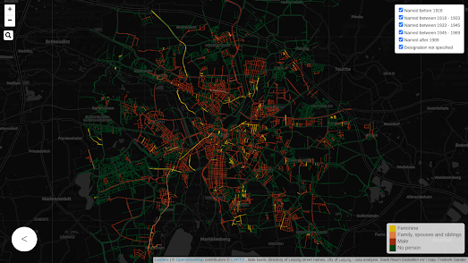
The Leipzig Gender Map is an interactive map which visualizes how many streets are named for men and women in the German city. The map clearly reveals the disparity in the number of street names which commemorate women compared to the number of streets which commemorate men.

On the map streets named for women are colored yellow and streets named for men are colored red (streets colored green are not named after people). In total only 119 streets in Leipzig have been named for women. In comparison 1,201 streets are named after men. Over half of the 119 streets named for women are not named after real women. For example a number of streets have been named after fairytale characters and Nordic deities. In total only 56 streets are named in honor of real historically prominent women.

All the colored streets on the Leipzig Gender Map are interactive. This means that you can click on a street to learn more about the derivation of its name. The city of Leipzig also maintains data on when streets were named (or renamed). The Leipzig Gender Map allows you to filter the map to show only streets named during different dates. You can therefore use these filters to analyze during which periods of the city's history streets were more likely to be named for women.

If you are interested in exploring the disparity of representation in street names in other major cities then you might like the maps created by Geochicas and EqualStreetNames. You can also find more examples under the toponym tag on Maps Mania.

пятница, января 13, 2023

Earthquakes with Depth

The World EQ Locator is an interactive map which visualizes the locations of historical earthquake data. The map also uses USGS data to show the locations and strengths of recent earthquake activity around the world. 

The map uses the ANSS Comprehensive Earthquake Catalog to plot the locations of historical earthquakes around the world. The marker for each earthquake on the map is colored to show the depth of its epicenter. The depth of each earthquake is also shown by its location on the 3D map in relation to sea level. Earthquakes can have depths from very near the Earth's surface to around 700 km deep. You can determine the exact measured depth of any earthquake by hovering over its marker on the map.

You can view the locations of recent earthquakes around the world by selecting the clock icon on the map. This will load a list of recent earthquakes recorded by the USGS. If you select any earthquake from this list its location will be shown on the map. The depth of selected earthquakes is also shown by the relative size of the vertical line shown above the earthquake's location on the map.

Another map which visualizes the depth of earthquakes is Earthquakes with Exaggerated Depth. Earthquakes with Exaggerated Depth is an interactive globe which visualizes one year's worth of earthquake activity around the world. The map was created by Esri's Raluca Nicola using data from the USGS.

On Raluca's transparent globe earthquakes which occurred between July 2017 and July 2018 are shown with their depth exaggerated by a factor of eight. Each earthquake is shown on the map using a colored circular marker. The color and size of the markers indicate the displayed earthquake's magnitude.

More than 75% of the world's volcanoes and around 90% of earthquakes occur in and around the basin of the Pacific Ocean. This area is commonly called the Ring of Fire. The reason for all this seismic activity in the Ring of Fire is the presence of converging tectonic plates.
The Pacific Ring of Fire can also be clearly seen on John Nelson's Seismic Illumination visualization. This map uses historical earthquake data going back to 1898 to show how earthquake activity reveals the Earth's tectonic plates. By concentrating on the Pacific Ring of Fire the map is able to show how continental drift causes seismic activity where the world's tectonic plates meet each other.

The Seismic Explorer interactive map also uses historical earhquake data to visualize 40 years of earthquake activity on Earth, including information on the magnitude, depth, and location of each recorded quake. The map uses data about recent seismic activity from the United States Geological Survey (USGS), and data from the Smithsonian Institution Global Volcanism Program on historical seismic activity around the world. 

On this map individual earthquakes are shown using colored and scaled markers. The colors of the markers represent earthquake depth and the size of the markers indicate the magnitude of the quake.The timeline control below the map allows you to view the seismic activity around the world for any date range. You can also press the play button to view an animation of global earthquakes from 1980 to the present day. 

Seismic Explorer also includes a cross section tool which allows you to view the depth data of earthquakes in a 3D view. You can use this tool to view an area of the globe as a cross-section, providing a three-dimensional view of the earthquake activity in that region. This allows you to view the depths of the earthquakes in that cross-section for any selected date range.

четверг, января 12, 2023

Beyond Snowfall

In 2012 the New York Times published a groundbreaking online article about the 2012 Tunnel Creek avalanche. The NYT's Snow Fall managed to seamlessly incorporate animated maps and other multimedia into its account of the avalanche in a way that didn't distract from the narrative flow. This integration of media and data within an online narrative was one of the first examples of the scrollytelling format.

William Davis's interactive map Snowfall owes more than just its title to the NYT's groundbreaking 2012 article. Davis's map is a fantastic visualization of snowfall in the United States over this winter. As you scroll the map visualizes 6-hour snowfall accumulation across the country from October 13 to December 18, 2022.

Like the NYT's original Snow Fall article William's Snowfall map seamlessly integrates the visuals within the emerging narrative. However while the Times employed an 11 person team for six months to produce Snow Fall William Davis single-handedly created Snowfall in a matter of days. Of course data visualization technologies have developed significantly in the decade since the Times published Snow Fall and I suspect William Davis was aided quite significantly by being able to adapt Mapbox's Scrollytell ing Template.

Which shouldn't distract at all from the beauty of William Davis's Snowfall map. As you scroll through Snowfall you advance chronologically day by day through the winter of 2022. As you do so it is amazing to be able to see daily snowfall accumulations instantaneously visualized on the Snowfall map. As you scroll information windows are also used to provide context about some of the significant and unusual snowfalls seen at locations across the United States over the course of the last few months.

I don't know if Davis's Snowfall is an intentional homographical homage to the NYT's 2012 Snow Fall article but it is a fantastic example of how data can be visualized on an interactive map.

среда, января 11, 2023

The Campaign for More Winter Sun

Today the residents of New York will see less than nine and a half hours of daylight. This lack of sunlight can lead to many people feeling SAD. Which is partly why every year there are calls to end the annual switch to standard time from daylight saving time, the result of which is that the sun sets even earlier every cold winter day.

It is also why FiveThirtyEight  has asked the question Can You Make Winter Less Dark? Obviously the answer is no but FiveThirtyEight have produced an interactive map which can help you find the best place to live in the United States if you would like a later sunset (or if you are an early riser where you should live for the earliest sunrises).

Percent of days with late sunsets

Essentially the FiveThirtyEight interactive is a map of the United States showing each time zone and colored to show the percentage of days with early sunrises and late sunsets. This map also includes the option to color the map only by the percentage of days with early sunrises OR to color the map only by the percentage of days with late sunsets. 

Percent of days with early sunrises

If you select to view the percent of days with late sunsets then you can see how this percentage increases as you move east and south of each time zone line. Conversely if you select to view the percent of days with early sunrises then you can see how this percentage increases as you move west and south of each time zone line. 

Obviously the actual number of hours of daylight remain the same with or without Daylight Saving. However the time you get up in the morning could affect how many hours of daylight you see. If you are an early riser then putting the clocks back in the Fall will probably result in you being awake for all the hours of sunlight. If you are a late riser then the clocks going back means that you are likely to miss some daylight time during the winter months.

The Daylight Saving Time Gripe Assistant Tool is an interactive map which allows you to play around with a number of different settings to explore whether Daylight Saving suits your sleeping patterns. Using the map you can explore how the geography of sunrise and sunset is affected by Daylight Saving across the United States. If you enter the time that you would like sunrise or sunset to be then the map will show you where in the United States it is best to abolish or always keep Daylight Savings (and where it is best to keep the current system).

If you live in Europe you can use Logan Williams' Daylight Saving Time Gripe Assistant Tool, Europe Edition. Logan has tweaked Andy Woodruff's original Observable notebook so that it works with a map of Europe. Again to use the tool you just need to enter your favorite time for sunrise or sunset and the map will then show you where in Europe it is best to abolish or always keep Daylight Savings (and where it is best to keep the current system).

вторник, января 10, 2023

All the Maps at Once

Hundreds of thousands of historical maps have been digitised by museums, libraries and organizations such as the David Rumsey Historical Map Collection. A very large number of those digitized maps can be accessed and viewed using IIIF

IIIF is a set of open standards for sharing and viewing online high-quality digital images. It is a format which is increasingly being used to digitize and share online historical vintage maps. For example I have recently used the IIIF manifests of vintage maps created by the John Russell Bartlett Library and the David Rumsey Historical Map Collection to create interactive annotated maps of:

&

Another great example of using IIIF to explore vintage maps is the Allmaps WebGL2 Preview. This interactive map uses the IIIF manifests of lots of different historical maps to overlay a number of different vintage maps on top of a modern map. 

You can use the location links on the WebGL2 Preview map to view vintage maps of Amsterdam, Boston, Delft and Harold Fisk's 1944 Meander Maps of the Mississippi River. The map also contains controls which allow you to adjust the opacity of the vintage map overlays and the underlying modern map.

The WebGL2 Preview was created using Allmaps. Allmaps is a fantastic platform which can be used to georeference vintage maps from a IIIF manifest and to display IIIF manifests as interactive maps. All you need to georeference or view a vintage map with the Allmaps Editor is the URL of a IIIF Image or Manifest. These manifest URL's are often freely shared on museum and library websites. 

The Allmaps Editor and the Allmaps Viewer both include links to lots of examples of vintage maps which have been georeferenced or which can be viewed using the Allmaps platform. 

понедельник, января 09, 2023

The Gendered Streets of Porto

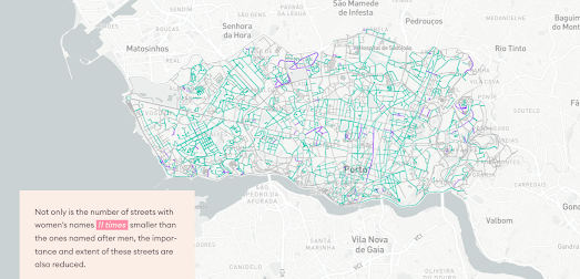
Ruas de Genero is a wonderful data visualization of the sexist toponymy of the second largest city in Portugal. By comparing the number of streets named for men and women in Porto and the length of streets named for each gender Ruas de Genero (Streets of Gender) explores how men and women are commemorated differently in the city's toponymy. 

In this interactive mapped visualization streets named for men and streets named for women are colored in order to highlight the disparity in representation in Porto's street names. On the map the light blue streets (named for men) clearly outnumber the purple streets (named for women). In fact 44% of Porto's streets are named after men and only 4% of the streets are named for women.

This sexist disparity of representation isn't only apparent in the number of streets named for each gender. It is also apparent in the names given to the city's most important streets. Ruas de Genero also analyzed the length of streets in Porto named for both men and women. It discovered that the most important gendered streets (determined by length) were all named after men. Whereas streets named for women tended to be shorter. According to Ruas de Genero 'the total length of streets named after men is 14 times bigger than the ones named after women'.

If you are interested in exploring the disparity of representation in street names in other major cities then you might like the maps created by Geochicas and EqualStreetNames. You can also find more examples under the toponym tag on Maps Mania. 

суббота, января 07, 2023

The Cost of Locking Up Americans

The United States houses around 1 in 5 of the world's prisoners. In fact 1.07% of all working age Americans are currently in jail. One obvious disadvantage of locking-up 1 in every 100 adults is the financial burden. The other 99 working age adults have to pay the huge financial cost of incarcerating so many Americans.

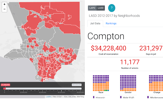
The largest jail system in the USA is in Los Angeles County and Million Dollar Hoods has mapped out how much is being spent on incarceration in every neighborhood in Los Angeles County. The name of the project should give you a little clue as to how much it costs to lock-up the residents in some LA neighborhoods.

The Million Dollar Hoods Map Room visualizes "the neighborhoods where LASD and LAPD spent the most on incarceration between 2012 to 2017." If you set the map filter control to $1 million you can see all the neighborhoods in LA County where the cost of incarceration is over one million dollars. 

According to the map locking-up the residents of Lancaster cost the county the most money. The Los Angeles Sherrif's Department spent $80,471,600 (2012-2017) to jail 19,910 people from the neighborhood. By my calculations 19,910 is nearly 12% of the entire population of Lancaster. Which means the Sherrif's Department locked up over 1 in 10 of the neighborhood between 2012 and 2017 (although I guess some of the residents may have been locked up more than once during that period - which would mean the percentage of the population jailed could be smaller). 

At the other end of the scale only 15 people in Angeles Crest were arrested in the same period. However the population of Angeles Crest is only just over 1,000 people. Therefore the Sherrif's Department still locked-up around 1.5% of the local population.

пятница, января 06, 2023

Weather Whiplash Animated Map

Weather Whiplash is a little experiment in overlaying a video on top of Mapbox's globe projection.

Earlier this week NASA released an impressive animation of the recent extreme weather conditions that have been experienced in North America. NASA's Weather Whiplash animation visualizes surface air temperature across North America, for December 2022 and the first few days of January 2023. The animation shows the extreme swings in temperature (from 36°F to 72°F) that many locations in the United States experienced in a very short period of time.

To create my video overlay map I cropped NASA's video and used Mapbox GL's video overlay capabilities to add the video as a layer on top of a globe projection. The Weather Whiplash map includes the option to pause and play the video by clicking on the actual video overlay. 

I'm far from happy with my map. I had to crop the map in order to be able to add to the globe projection which means I lost the date label from NASA's original video. I also had to use clideo.com's cropping tool to crop the video which is why the video has an ugly watermark. I also had to georeference the video by eye (which is why it is positioned so poorly). If anyone has a link to an online rubbersheeting tool for videos (like MapKnitter for images) that would be much appreciated.

четверг, января 05, 2023

The Land of Generation X

Modal Age by Neighbourhood is an interactive map which visualizes the median age of the population in English and Welsh neghborhoods (middle-layer super output areas), using data from the 2021 census. The map provides a fascinating insight into the average ages of the countries' towns and cities (a Median Age map is also available).

By area of land (but not necessarily by population) England and Wales belongs to Generation X. According to this map in most rural areas of England and Wales the average year of birth comes between 1965 and 1980. However in most of the large towns and cities of England and Wales the largest generational group is Millennials (1981-1996). 

Boomers born 1946-1964 appear to like to retire the coast. The coastlines of Somerset, Devon and Norfolk all contain neighborhoods where the average age is over 56. At the other end of the scale, if you want to find neighborhoods dominated by Gen Z (born 1997-2021) you need to look in University towns.

Alasdair Rae has also been publishing a number of visualizations of census age data to his Twitter stream, including this impressive animated map showing the percentage of people of every age (0-100).

вторник, января 03, 2023

Mapping Police Killings

The animated map above shows people being killed by the police over the course of 2022. 1,176 people in the United States were killed by the police last year. That means that on average 3.2 people a day were killed by the police during 2022. 

The map and the data comes from Mapping Police Violence. Mapping Police Violence collects and publishes data on police violence across the United States. Unfortunately they aren't very good at mapping. The animated map shown above, which visualizes police killings in 2022 by date and place, has been produced to convey the scale of police violence against U.S. citizens. However it isn't very effective at showing the per capita rate of police killings across the country.

The Cities page on Mapping Police Violence does provide graphs which allow you to compare the rate of police killings by population in major U.S. cities. This data seems to suggest that the St. Louis Metropolitan Police Department has lost complete control. The St. Louis Metropolitan Police Department rate of 15.9 killings per 1m (2013-2022) is way ahead of the Tulsa Police Department, who have the second highest rate (9.4) of police killing of American police departments.

понедельник, января 02, 2023

SatellitExplorer

Esri's Geo Experience Center has released an awesome interactive map which plots the locations of satellites orbiting the Earth. This 3D celestial map also does a very good job at explaining what satellites are used for, who owns them and the various types of orbits that the satellites follow.

The Satellitexplorer 3D map shows the Earth surrounded by thousands of satellites and tens of thousands of space debris. Along the bottom of the map are four options which allow you to explore the 'Purpose', 'Orbits', Owners' and 'Debris' of Earth's satellites. Select one of these options and you can learn everything you ever wanted to know about how and why satellites are used.

If you use the map's search facility you can also search and track individual satellites on the map. For example if you search for 'ISS' you can view the current location of the International Space Station and follow the satellite as it travels around the Earth in its low Earth orbit.


You can get a first person view from the ground of all these orbiting satellites on See a Satellite Tonight. James Darpinian's See a Satellite Tonight can tell you at what time tonight satellites will fly over your house. It can also show you exactly where to look in the night sky if you want to see a satellite passing overhead.

Share your location with See a Satellite Tonight and you can view an interactive 3D Cesium Earth map, showing your current location highlighted on the globe. The globe also features an animation of any satellites passing over your home tonight. The map menu (running down the left-hand side) tells you at what time a satellite will be flying overhead. It also includes, in chronological order, options to view any other satellite passes over your house tonight and on subsequent nights.

You can find more interactive satellite maps by exploring the Astronomy tag on Maps Mania.