среда, марта 31, 2021

Mapping Earth's Climate History

The Hadley Centre Central England Temperature data-set is the world’s longest running climate record. Since 1659 it has recorded the mean, minimum and maximum temperature every month since the middle of the 17th Century in central England. However, although the Hadley Centre data-set contains temperature records for over 350 years, it is still only a tiny snapshot into the world's climate during a minuscule period of the Earth's history. 

If we want to learn more about how the climate of the Earth has changed over the long term we need to look at other data. Luckily the ebb and flow of the climate can be detected from lots of different geological and natural processes. Climate scientists are able to observe long-term changes in the Earth's climate using 'proxy data', from the effect that the climate has on the biosphere.By looking at how different climatic conditions leave traces on the environment we can learn more about how the climate has changed over huge periods of time. For example, the effect of changes in the climate can be observed in the layers of ice sheets, in sediments at the bottom of lakes, in tree rings, and in the development of stalagmites.

Using these natural and geological 'proxy data' sources climate scientists can begin to understand the long-term changes in the Earth's climate and begin to put the current accelerated climate heating in a longer-term context. 

In Mapped: How ‘proxy’ data reveals the climate of the Earth’s distant past Carbon Brief has put together an interactive map which plots thousands of different 'proxy data-sets' around the world that scientists use to study the history of Earth's climate. NOAA has as archive of over 10,000 different 'proxy data-sets' used for exploring historical climate records. It is these data-sets that Carbon Brief has mapped. 

If you select any one of the thousands of 'proxy data-sets' shown on the map you can learn more about the period of Earth's history that it covers, the site name and a link to NOAA's reference webpage for the data-set.

вторник, марта 30, 2021

Discovering Local History and Culture

Clio is an interactive map based tool for discovering nearby historical and cultural sites across the United States. Enter your address into Clio and it will show you the location of nearby historical sites, museums, monuments, landmarks and other sites of cultural or historical significance.

When you search for a location on Clio all the nearby sites of historical importance are shown on an interactive map using numbered map markers. You can either click on the individual markers to learn more about the mapped historical site or you can view each entry listed beneath the map. 

Clio users can also contribute entries to the map, to add important cultural or historical sites which aren't already listed. To add a site to the map you need to register with Clio. Clio moderates all submitted sites, therefore if you add an entry it won't be immediately added to the map.

Clio can be used to create walking tours of local places of historical importance. For example in New York you could create a walking tour around local historic theaters. Creating a tour is easy for registered users and really only requires you to select individual historic sites from the map. Clio will create the walking route automatically to visit all your chosen sites. If you don't like route designed then you can simply reorder the chosen locations to change the route of your personal walking tour.

Can You Navigate the Suez Canal?

Thanks to the Ever Given we are now all aware that steering a 1,312-foot, 220,000 ton container ship is fraught with difficulty. With the help of a new map based game from CNN you can actually test how well you would cope with navigating the Suez Canal.

CNN has put together a little game which requires you to steer a large ship through a small section of the Suez Canal. CNN's Steer Through the Suez Canal map game was designed with the help of Master Mariner Andy Winbow and Captain Yash Gupta. The game requires you to use speed and direction controls to steer a large ship through a few thousand feet of the canal, fighting cross winds and trying to avoid crashing into the sides of the canal.

CNN's game is really just a little bit of fun and they acknowledge that the game bears little resemblance to the real difficulties of piloting a huge container ship. In real life a captain navigating the Suez Canal would also have to deal with the variable depth of water; the proximity of the banks; passing ships; and other weather conditions like visibility.

понедельник, марта 29, 2021

Mapping Vaccination Rates

The Washington Post has released an interactive map which visualizes vaccination rates at the county level in the United States. Using the Post's Detailed Picture of Vaccination Across the Country map you can discover how well your county is progressing in administering the Covid vaccination and how well it compares to other counties.

The map uses data from the Centers for Disease Control and Prevention to show the percentage of the population vaccinated in each county. According to the Post's analysis of the data there are "notably lower rates in predominantly Black areas and counties that voted most heavily for President Donald Trump in 2020." Eight of  the top ten most vaccinated counties are in Alaska. The Post explains that this is partly due to the success of the Indian Health Service in vaccinating Alaska Natives.

The New York Times is tracking the progress that countries around the world are making in vaccinating their citizens. You can view the results on the newspaper's Tracking Coronavirus Vaccinations Around the World interactive map. 

The NYT's map shows that Israel is still leading the world in the roll-out of the vaccine. The UK and the USA are also doing well if you look at those countries who have given the most first shots of the vaccination. Most countries in the European Union appear to still be struggling to implement speedy vaccination programs for their populations.

The NYT's vaccination tracking visualization also allows you to see how individual U.S. states are progressing with their vaccination plans. See How the Vaccine Rollout Is Going in Your State shows that New Mexico, Connecticut and Alaska are leading the way (although they are behind the pace of Palau & American Samoa). At the other end of the scale Georgia, Alabama and Tennessee are among the slowest states to roll-out vaccinations to their citizens. 

You can find many more mapped visualizations of Covid-19 infection rates, deaths and vaccinations under the health tag on Maps Mania.

Evergreen Anti-Shipping

A new interactive map shows how the Evergreen shipping company could effectively bring international marine traffic to a halt with just a few carefully positioned container ships.

Ever Given Every Where allows you to superimpose an image of the Ever Given container ship at any location on the Earth on top of a satellite map. As you can see in the screenshots on this page with just a few ships you could block access to the Mediterranean Sea, the Baltic Sea & the Panama Canal and block the gap between the USA and Russia across the Bering Strait.

The Strait of Gibraltar is around 8 miles wide so some of these well positioned container ships would have to be very large indeed to block these shipping lanes in real life. Luckily for those who wish to use the 'Ever Given Every Where' map to virtually bring the world's shipping trade to a halt you can make the aerial image of the Ever Given ship as small or as large as you want. So if you need to block the 8 mile wide entrance to the Mediterranean Sea you can just enlarge your ship on the map. 

If you want to see an imaginative solutios to freeing the Ever Given from the Suez Canal then you should have a look at Pratik Yadev's 'Unstuck Ever Given'. Pratik's Unstuck Ever Given 3D animated map shows how two Space X rockets could easily lift a 220,000 ton container ship out of a tight space. In fact the only shocking part of Pratik's plan is that Elon Musk hasn't already suggested it.

If you have a desire to know if the Ever Given has been freed yet then you can always refer to the very useful 'Is the Ship Still Stuck' interactive map. Is the Ship Still Stuck carries a simple 'Yes' or 'No' message, informing you as to whether the Ever Given is stuck in the Suez Canal. It also uses an interactive map from Vessel Finder, which shows the near real-time location of the Ever Green, so that you can see for yourself if the ship is still stuck in the canal, with a current speed of 0 km.

пятница, марта 26, 2021

The Interactive Mao Kun Map

The Mao Kun map is the earliest Chinese map to accurately map Southern Asia, Persia, Arabia and East Africa. The map was first published in the 17th century in the military treatise Wubei Zhi. The introduction to the map in Wubei Zhi suggests that the Mao Kun charts are based on documents from the expeditions of Zheng He, suggesting that the map dates back to at least the 15th Century. 

The Mao Kun map is also sometimes known as Zheng He's Navigation Map. The map is a long strip map charting the sea route from the Ming capital in Nanjing to the East Coast of Africa (the map is arranged from right to left, starting from Nanjing and finishing in Hormuz.).

The Mao Kun Explorer is a fantastic interactive map which displays and synchronizes the 17th Century Mao Kun strip map with a modern day map of the world. The original map contains over a hundred place-name labels. These labels have been made interactive on the Mao Kun Explorer. Click on one of these Chinese place-name labels on the Mao Kun map and you will be shown the location on the modern map. A small information window will also translate the Chinese place-name label into English.

Superimposed on top of the Mao Kun map is a small inset map which allows you to view the modern day countries that the Zheng He expeditions passed through. Click on this inset map and both the modern map and the Mao Kun map will pan to the selected country.


The Mao Kun Explorer was inspired by Professor Anthony Barbieri's Interactive Zheng He Sailing Map. This interactive version of the map was created by Professor Barbieri of the University of California, Santa Barbara. His map also includes translations of the Chinese place-names on the original Mao Kun map. 

If you hover over the place-names (highlighted in red on the map) you can read the English translation. If you click on a highlighted place-name you can view the selected location on Google Maps. All these translated and mapped locations are also available from a drop-down menu, which provides a quick way to find a location on the map. A small inset map runs along the top of the map to show where you are currently looking on the huge strip map.

The dotted lines on the Mao Kun map are sailing routes. The Chinese text along these routes provide sailing instructions, including compass points and distances. The sailing instructions are more detailed in the Chinese waters, presumably because the cartographer had a greater knowledge of these. The map as a whole is also more accurate in Chinese territory and becomes less complete the further west it goes.

How to Free the Ever Given

For nearly three days a huge container ship has been stuck in the Suez canal. This has caused huge disruption to global shipping. Rerouting ships around the continent of Africa instead of using the canal can add up to 9,000 kilometers to a journey, adding 8-10 days to a journey. 

So far efforts to free the Ever Given from the canal have involved trying to pull it free with tug-boats and / or widen the canal with mechanical diggers. These attempts have so far proved hugely unsuccessful. Pratik Yadev has therefore devised a radical new solution as to how a long container ship can be freed from a narrow canal. This solution is to use two Space X rockets to vertically lift the Ever Green free from the canal.

Pratik is aware that his idea may sound a little crazy. Which is why he has used Mapbox GL to demonstrate how his proposal would work in practice. Pratik's Unstuck Ever Given interactive map animates how two Space X rockets could easily lift a 220,000 ton container ship out of a tight space. In fact the only shocking part of Pratik's plan is that Elon Musk hasn't already suggested it.

BTW if you have a desire to know if the Ever Given has been freed yet then you can always refer to the very useful 'Is the Ship Still Stuck' interactive map. Is the Ship Still Stuck carries a simple 'Yes' or 'No' message, informing you as to whether the Ever Given is stuck in the Suez Canal. It also uses an interactive map from Vessel Finder, which shows the near real-time location of the Ever Green, so that you can see for yourself if the ship is still stuck in the canal, with a current speed of 0 km.

четверг, марта 25, 2021

How to Make Lockdown Walks Interesting

Last week one of my neighbors complained about how she had become incredibly bored having to walk the same streets and parks over & over again during lockdown. I told her that I would put together a list of online maps which I find useful for discovering more about the history of our local neighborhood.

The following list of interactive maps are mostly UK and London specific. However, even if you don't live in London, you may still find these maps interesting and in most cases you should be able to find similar maps which provide the same type of local historical information about where you live.

Wikimapia

One of the best online maps for discovering more about nearby points of interest is Wikimapia. For over ten years Wikimapia has provided a great map based resource for discovering information about locations and points of interest around the world. 

In essence Wikimapia is an interactive map which lets you describe physical locations in the same way that Wikipedia allows you to add and edit articles in its wiki database. Like Wikipedia it provides an invaluable resource for researching and discovering information about the world - only with Wikimapia every entry is a real-world location.

To use Wikimapia you just need to search for a place on the map and click on any of the highlighted areas to discover information about the selected location. For example, if you see an interesting looking building on your daily walk, you just need to click on the building on the Wikimapia map to read its Wikimapia wiki entry. 

Historical Ordnance Survey Maps

Wikimapia is a great resource for discovering more about existing landmarks and buildings. It isn't always so informative about the historical buildings and landmarks which, for whatever reason, no longer exist. I always find it fascinating using old Ordnance Survey maps to explore how my neighborhood has developed and changed over the last 150 years.

The National Library of Scotland's Ordnance Survey Map Finder is a great way to find and view vintage Ordnance Survey map of British towns and cities. Using the library's online map you can find old Ordnance Survey maps dating back as far as the 1860s. By exploring your neighborhood on these historical maps you can learn a lot about your area has developed over time and about some of the local historical landmarks and buildings which have been replaced by more modern developments.

Bomb Sight

If you live in London then the amazing Bomb Sight is a fantastic resource to discover the nearby locations which were bombed during World War II. Bomb Sight shows the location of bombs that landed during the war using data taken from a number of different sources. Chief among these sources are the maps created during the Bomb Census Survey 1940 to 1945, which was organized by the Ministry of Home Security.

As you can see from the screenshot above the map shows the locations of thousands of bombs that landed on London during World War II. In most neighborhoods in London's East End you can tell where bombs fell by the location of post-1940's buildings. You can use the Bomb Sight interactive map to confirm where bombs fell on your neighborhood during the war.

The Archaeology of Greater London online map

During lockdown I have turned time & time again to John Rogers' YouTube channel. John is a London-based film-maker and writer who has made hundreds of videos about interesting London walks.On one of his videos John explained how he uses The Archaeology of Greater London Online Map to learn more about some of the local prehistoric history which is hidden beneath our modern roads and streets.

The Archaeology of Greater London Online Map was created by the Museum of London Archaeology to show the locations in London of some of the most interesting archaeological finds and sites from London's prehistoric, Roman, Saxon, and medieval history. Using the map you can find the locations near you where important archaeological finds have been made. 

The map is a great resource for discovering more about the ancient history of your local neighborhood.For example the map reveals that a neolithic axe was discovered at the end of my road.and a Bronze Age settlement also used to exist nearby. This Bronze Age settlement has made no lasting impression on the modern urban landscape but on my walks I can still imagine a small settlement hidden in the low-lying marshes which dominated this area during the Bronze Age.

среда, марта 24, 2021

Mapping Where the Rivers Flow

Over the last few days Stamen Design has been busy creating animated maps which visualize some of the major watersheds of the world.

The animated maps in Visualizing the World’s Watersheds shows the flow of water starting at the most upstream locations in a major watershed and ends where these rivers eventually enter into the oceans. These animated maps are a great visualization of individual watersheds. For example the GIF above of South America's major watersheds perfectly illustrates how the Andes on the east of the continent contributes to the huge watersheds which flow west across nearly the whole continent and into the Atlantic Ocean.  

Stamen has also created animated maps which visualize the flow of the major watersheds in North America, Asia & Oceania.

If you are interested in exploring other interactive visualizations of the world's watersheds then you might also enjoy these maps:

The Watersheds Map allows you to visualize watershed regions throughout the USA. As you mouse-over the map it automatically updates to show upstream areas in red and downstream areas in blue. The map allows you to visualize over 100,000 watershed regions in the United States.

The Watershed Explorer interactive map allows you to click anywhere in the world to view all of its upstream areas and the downstream flow.When you click on this map a high-resolution digital elevation model is used to calculate the flow direction that water would take at every point on the surrounding land. The map then follows "these directions to calculate the region that contributes to a single outlet".

The USGS's Streamer map allows you to trace rivers or streams upstream to their source or downstream to their final destinations in the USA. The interactive map can create very dramatic visualizations of river watersheds, particularly when you trace a river upstream to show all of its tributaries.

The Continuing Legacy of Redlining

In the 1930s, under President Franklin D. Roosevelt's New Deal, black homeowners across the United States were discriminated against through the creation of redlining maps. These maps identified areas with significant black populations and labeled them as too high risk for mortgage support. Black homeowners living in these areas were therefore very unlikely to be successful when trying to refinance home mortgages from the government sponsored Home Owners' Loan Corporation. 

Unfortunately the racial discriminatory mortgage assessments of the 1930s have had a lasting legacy on American cities. A legacy which can still be felt in the United States today. Neighborhoods which were redlined as too high risk for mortgage lending in the 1930s have suffered from decades of under-investment in critical infrastructure. This historical under-investment means that anyone living in a once redlined neighborhood today is still likely to have less access to health care, be more at risk from extreme summer heat and is even at more risk of flooding than people living in neighborhoods which weren't redlined under Roosevelt's New Deal.

Flood Risk

One of the least obvious legacies of redlining is increased flood risk. It might not be immediately obvious that the denial of mortgage support in the 1930's would lead to a higher risk of flooding. However Bloomberg has released a convincing story map which shows that redlined neighborhoods in the U.S. have a much higher flood risk than their more affluent neighbors.

Bloomberg's Redlined, Now Flooding compares historical redlining maps with modern flood risk maps. This comparison reveals that in cities across the United States there is a greater risk of flooding in formerly redlined neighborhoods than in more affluent neighborhoods in the same city.

The reason why redlined neighborhoods have a higher flood is a direct result of "disparities in development compounded by decades of disinvestment". Since the 1930's more affluent neighborhoods have received greater investment in essential infrastructure compared to less affluent redlined neighborhoods. The result is that redlined neighborhoods are now at greater risk of flooding. And not just flooding ...

Urban Heat Islands

Redlined neighborhoods don't just face a greater risk of flooding. Since the New Deal's racially discriminated mortgage lending assessments of American cities redlined neighborhoods have continued to face under investment in infrastructure compared to the more wealthy greenlined neighborhoods. 

For example, last year the New York Times mapped out how racist housing segregation, dating back to the Home Owners' Loan Corporation's Redlining maps, is a major contributory factor to the location of urban heat islands in modern towns and cities across the United States. In How Decades of Racist Housing Policy Left Neighborhoods Sweltering the NYT uses a story map to show how across the United States neighborhoods which were redlined are now usually the hottest parts of towns and neighborhoods which weren't redlined tend to be the coolest. 

The reason for this is that redlined neighborhoods have largely remained areas of deprivation and tend to have fewer trees and a denser built environment than more affluent neighborhoods. Non-redlined neighborhoods are  more likely to have lots of parks, grass and far more trees. All factors which help to deter the build-up of urban heat.

Health Inequality

The legacy of the Home Owners' Loan Corporation (HOLC) redlining maps can also still be seen in the health inequality in cities today. The Digital Scholarship Lab and the National Community Reinvestment Coalition has used maps to show how redlined neighborhoods suffer severe health disparities in the 21st Century compared to more wealthy neighborhoods.

Not Even Past: Social Vulnerability and the Legacy of Redlining allows you to directly compare redlining maps with modern maps which visualize the modern health disparities in U.S. cities. Select a city on the Not Even Past website and you can view its HOLC redlining map placed side-by-side with a map which shows the CDC's current Social Vulnerability Index scores for the city's neighborhoods. This allows you to make a direct comparison between the two maps and see where the health disparities in your city today are a partial legacy of historical redlining.

Racial Segregation

One of the biggest lasting legacies of redlining has been the continuing racial segregation seen in many American cities. Wenfei Xu's Redlining Map visualization allows you to explore for yourself if the HOLC redlining maps have had a lasting impact on segregation in your city. Using modern census data alongside the HOLC redlining maps you can see which neighborhoods  have a high percentage of black, white or Hispanic people and see if these areas correlate with areas which were deemed at risk or safe for lending purposes in the 1930's. 

You probably won't be surprised to discover that black Americans are far more likely to live in neighborhoods  which were redlined 90 years ago. The result of the continuing disinvestment of America's once redlined neighborhoods is that many black Americans today live in the neighborhoods which have the lowest average incomes, the poorest access to health services, the worst urban heat islands and are at greater risk of flooding.

вторник, марта 23, 2021

Global Elevation & Bathymetry Data

Last week I posted a short review of Nicolas Lambert's Elevation Scan, a clever interactive map which visualizes the relative elevation of land across the world. Nicolas has now created a very similar map which also visualizes global bathymetry data.

Press the 'play' button on the Elevation Scan (with bathymetry) map and a line moves north from the bottom of the map to the top. As the line moves a graph shows the elevation height on land along lines of latitude. Over the world's oceans and seas the graph also shows sea depths. For example on the screenshot above you can see the high elevations of the Himalayas rising up from the line of latitude running across the map. To the right of the Himalayas you can also see the huge depths of the Mariana Trench in the Pacific Ocean.

If you press 'pause' you can manually explore the map and the relative elevation or bathymetry of locations around the world by moving the slide button left and right. The map also includes buttons which allow you to turn the elevation or bathymetry data on or off on the map.

Mapping Mumbai's Coastal Ecosystems

If you live in Mumbai and have ever wondered about the types of marine life which live on the local shores of the Arabian sea you can now refer to a new interactive map which explores the types of creatures which live on the city's beaches. 

Marine Life of Mumbai is an interactive map of a virtual Mumbai shore which shows the three common ecosystems which exist on the coast of Mumbai and the marine life which can typically be found living in each. The map presents three virtual habitats: a sandy, rocky and a muddy shore. Explore these habitats closely on the map and you will find lots of different examples of marine life. Click on any of the creatures shown on the map and an information window will open with a photo and information on the selected creature.

The Marine Life of Mumbai interactive map was created using a static image of Mumbai's virtual shore with the Leaflet,js mapping library. The Non-geographical Maps example in the Leaflet tutorial provides a good starting place if you want to create your own interactive map from a static image. This shows you how you can use L.ImageOverlay to add a static image to a Leaflet map. 

Using L,ImageOverlay is the simplest way to map a static image with Leaflet. You can also create a full set of interactive map tiles from an image if you want to create a map with a very high resolution and lots of zoom levels. Bjørn Sandvik has written a neat Leaflet plugin (code available on GitHub) which can help you create a Leaflet map from a photo or other static image using Zoomify. Showing Zoomify Images with Leaflet  explains how to use the plug-in to create a Leaflet interactive map from a Zoomified image. 

You can view lots of other interesting examples of Leaflet maps made from large static images on the Maps Mania post Microscopic Mapping

понедельник, марта 22, 2021

New York Bike Maps

If you want to cycle in New York then you might find the NYC Bike Map a useful guide to where it is safest to cycle and where you can find places to park your bike.

The NYC Bile Map uses data from NYC OpenData, Citi Bike and elsewhere to map the location of bike lanes, bike racks, bike shelters and biking hazards. Protected bike lanes, which are separated from motor vehicles, are shown on the map with dark green lines. The lighter green lines show on street bike lanes, which are mixed with vehicular traffic. The yellow lines indicate routes which are entirely mixed with vehicular traffic.

Black arrows on bike lanes indicate the direction of travel. Steep hills are shown with red triangles and stairs are indicated with a red stepped symbol. The location of bike racks and bike shelters are shown on the map with their own bike symbols.


Cycling in New York can be dangerous. Especially between 6-7 pm and during the month of September. You can see how precarious it can be to bike in New York on the NYC Cycling Incidents Map.

Each dot on the map shows the location of a cycling accident. The map shows that there aren't many sections of the city's roads where cyclists haven't been injured. The charts and graphs accompanying the map reveal the number of cycling accidents by time of day and by month. You can also click on these charts to filter the accidents shown on the map by time of day and the month of the year.


NYC Bike Maps is another useful resource for New York cyclists. This site includes a number of Google Maps of the city's boroughs, displaying bike lanes, bike paths and other information useful for cyclists.The separate and individual borough maps on NYC Bike Maps are a useful guide to navigating different neighborghoods of the city by bike. There is a also a map of the city's cobble-stoned streets and a handy Five Boro Bike Tour Map. 

Mapping Seasonal Fruit & Veg

If you are keen on lowering your carbon footprint then you should try to eat local and seasonal food when possible. Now a new European-wide interactive map can help you discover which fruits and vegetables are both local and in season.

Last week the European Food Information Council launched Europe's first interactive map of seasonal fruit and vegetables. The Explore Seasonal Fruit and Vegetables in Europe map allows you to select a month and a country to discover all the fruit and vegetables which should be in season in your chosen country. Buying and eating these locally grown seasonal foods can help you to develop a sustainable diet. 

The Explore Seasonal Fruit and Vegetables in Europe interactive map also includes a climate layer, which shows the six European climate regions. Each of these climate regions has different weather conditions over a long period of time. The climate regions obviously effect when the different fruits and vegetables are in season across the different regions of Europe.


You can learn more about local and regional foods and dishes on the TasteAtlas. The TasteAtlas is an interactive map which allows you to explore the local foods, dishes, tastes and cuisine of any location in the world. Using the map you can search different locations to discover the kinds of things the locals like to eat and drink. It is a great way to discover the tastes of different regions of the world and, at the same time, get a little inspiration about what to have for dinner tonight.

A great feature of TasteAtlas is that you can search the map for individual foods. For example here is the cheese map of the world and here is the bread map of the world. Search for a particular type of food and you can zoom-in on the map to discover the local varieties available at different locations. For example, on the cheese map you can zoom-in on France to discover all the local varieties of cheese available in different regions of the country. Or, if you search for the pasta map of the world, you can find out which different types of pasta come from the different regions of Italy.

суббота, марта 20, 2021

Music Maps of the World

lo-fi earth map

lo-fi earth is a Google Map which allows you to virtually explore the Earth while listening to the laid back tunes of lo-fi earth. lo-fi hip-hop is a laid back and chilled genre of music which marries hip-hop with jazz 'to create an atmospheric, instrumental soundscape'.

While the music plays you can explore the world on the interactive satellite map. This map includes a heat-map layer which updates to show all the places that you have explored. It also includes heat-map breadcrumbs showing you where other people have also been exploring the map since you started listening to lo-fi earth.

lo-fi earth also includes a camera button which allows you to take snapshots of places on the map as you explore the world. 


If you enjoy listening to music while exploring the world on an interactive map then you should also like the marvelous Radiooooo, global music map. Radioooo allows you to listen to music from anywhere in the world and from any decade going back to 1900.

To start listening to music on Radiooooo you just need to click on a country on the map. You can then select a decade using the buttons at the bottom of the map. The map will then automatically stream music from the country & decade which you have chosen. Radiooooo also includes an option to select the 'mood' of music that you wish to hear (slow, fast or weird). The 'Taxi' option even allows you to select to listen to music from more than one country.


You can also listen to music from around the world on Radio Garden. From the Pacific sounds of Radio Guam to the Siberian tunes of Radio Sabir, the Radio Garden 3d map allows you to listen live to thousands of radio stations across the globe.

Radio Garden features radio broadcasts from hundreds of countries around the world. Just click on a marker on this interactive map and you can tune in to local radio stations which provide live internet radio streams. Radio Garden is a great way to explore the sounds of different cultures around the world. It also provides an interesting insight into the broadcasting traditions of different countries.

пятница, марта 19, 2021

The D.C. Helicopter Map

There are a lot of helicopters flying over Washington D.C. If you ever want to know more about a chopper currently hovering overhead you can use the Helicopters of DC twitter bot. This Twitter account identifies the make, altitude and owners of helicopters flying in D.C. and then posts that information on Twitter. If you spot a helicopter in the city then there is a good chance you can discover what type of helicopter it is and who it belongs to on the Helicopters of DC Twitter account.

Helicopter of DC also maintain the interactive CopterSpotter map. Helicopters identified on the Helicopters of DC Twitter account are also added to the CopterSpotter map. The map therefore provides a reasonable overview of the helicopter activity in the capital. The map includes a date range filter so you can explore helicopter activity during specific periods of time.

Helicopters are shown on the map using colored markers. These markers indicate the operators of the helicopters shown on the map. Police helicopters are shown with red markers. Yellow markers show medical helicopters. The green dots show the President's helicopter - or Marine One (the President's helicopter is only given the call sign 'Marine One' when the President is on board).

Personal Air Pollution Reports

If you live in the UK you can get a personal air pollution report for your home from the Central Office of Public Interest. Simply type your postcode into their Address Pollution website and they will tell you the levels of NO2, PM2.5 and PM10 commonly found at that address. 

Share an address with Address Pollution and it will show you the levels air pollution found there on top of a Google Map Street View image of the address. This air quality report provides the annual NO2, PM2.5 & PM10 levels found at this address and tells you whether these levels are within the World Health Organization's recommended limits. The air quality data used in the report comes from Imperial College.


Every year the UK government provides its own annual estimates of greenhouse gas and air pollutant emissions in the UK. These estimates are compiled using 'internationally-agreed methods' using data from a number of different government departments, agencies and commercial organizations.

The UK Emissions Interactive Map allows you to explore the National Atmospheric Emissions Inventory for 2018 on an interactive map. The map shows the UK locations with the highest and lowest pollution levels for different types of emissions and also shows which sites around the UK produce these emissions. Using the map you can zoom in on any location in the UK and view the estimated levels of a number of different types of pollutants. These pollutants include NO2 emissions, Particulate Matter, Lead, Methane and many other types of possible harmful emissions.

This map also allows you to view the sites which are the major cause of each type of emission. If you select the 'show sources' option the map changes from a heat map view of the emissions to show where these emissions come from. Clicking on a source's marker will reveal the name and the amount of emissions that is produced at that location. 

четверг, марта 18, 2021

Political Segregation in America

The New York Times has mapped out the sharp political divide which exists in many American cities. Using data of party registrations the NYT shows how a partisan divide splits many cities in two, with many voters living in cities segregated along political lines.

In A Close-Up Picture of Partisan Segregation, Among 180 Million Voters the NYT uses a series of static maps to show where voters support the Republican and Democratic parties in major U.S. cities. These maps reveal how Democrats and Republicans live separated from each other, often in completely separate neighborhoods. The NYT analysis shows that even in neighborhoods with both Republican and Democratic supporters people still tend to live close to people who vote the same way as them.  

The NYT discusses the effect that this segregation has on American life, particularly at how segregated neighborhoods can lead to the demonizing of those with opposing political views. If you want to explore the levels of political segregation in your state then you can refer to Kenneth Field's interactive map of the US Presidential Election 2020. This interactive map visualizes 160 million voters as colored dots. The blue dots show Democratic voters and the red dots show Republican voters.

It is important to note that on Kenneth's map voters are randomly distributed within county areas so it won't show the political divide within individual neighborhoods. However the map does show the divide between different counties and how voters are divided within individual states. 

2021 Dutch Election Maps

The center-right VVD party were the biggest winners in yesterday's general election in the Netherlands. This means that the Prime Minister, Mark Rutte, will now serve a fourth term as leader of his country. 

Sixteen different parties will probably win seats in this Dutch parliament. This normally means that it can take a while for a working coalition to emerge. One of the VVD's current coalition partners, the pro-European D66 party, also gained seats in this election. The far-right, anti-Islam Freedom party (PVV) lost three seats. The left wing PvdA appear to have won the same nine seats as in the last election but the other left-leaning parties - the Greenleft and Socialist party - both lost seats.

De Volkskrant has published an interactive map which is visualizing the results in each electoral district as they are declared. The largest party (grootste partij) view on this map shows that the VVD were the most popular party across almost the whole country. The map also includes an option to compare the 2021 election results with the previous election in 2017. You can view a more detailed visualization of the 2017 election using NRC's interactive dot map All Votes as Ten Million Dots, which shows every vote cast in the 2017 election as colored dots. 

De Telegraf has also published an interactive map which shows the results of the 2021 Dutch election as they are announced. Like De Volkskrant's visualization De Telegraf's interactive map allows you to view the biggest party in each electoral district, the distribution of votes won by each party, the number of seats won by each party and a 'coalition builder' view. The coalition builder allows you to explore which parties could form together to create a working coalition with a majority of 76 seats.

Dutch newspaper NRC has also followed the same well trodden path for its 2021 election map. The NRC election visualization also includes an interactive map view, a graph showing the distribution of votes won by each party, a graph of the seats won by each party and a coalition builder tool.

среда, марта 17, 2021

Color Schemes for Maps


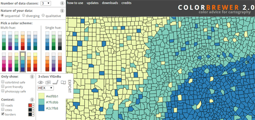
When I need to visualize data on a map I nearly always use ColorBrewer to help me use an appropriate color scheme. Cynthia Brewer's ColorBrewer is an online tool to help cartographers choose good color schemes for their maps. The tool helps you to think about what type of data you are visualizing and what would be an appropriate color scheme.

The tool includes three types of color scheme, sequential, diverging and qualitative. You simply need to choose which scheme best fits your data, choose the number of classes in your data and then choose a multi-hue or single color palette range. As you make your design decisions you can automatically see the scheme being applied to a sample map.

Whether you should choose a sequential, diverging or qualitative color scheme depends on the type of data you are visualizing. if you want some help on what type of color scheme you should use then you can now refer to Lisa Rost's new data visualization guide Which color scale to use when visualizing data. This four part guide provides expert advice on which type of color scheme to use with what kind of data.

Lisa Rost's four part guide explains the difference between the different types of color scheme you can use to visualize data. It provides advice on when you should use a qualitative color scheme and when you should use a quantitative scheme; when you should use sequential or diverging color schemes; and when you should use classed or unclassed color schemes.

The Corridors and Slums of Amsterdam

The fabric of Amsterdam is defined by its canals, its tall narrow buildings and its network of streets and alleys.Amsterdam also has lots of 'gangen'. These are small alley like paths between buildings which, unlike alleys, don't lead to another street, but instead lead to a dead end. These narrow corridors often lead to enclosed courtyards. Because these enclosed courtyards are hidden from the main thoroughfares in the past they were often colonized by the less fortunate, who would build dilapidated shelters or illegal buildings in which to live. 

Old gangen can be found throughout the center of Amsterdam but are more prevalent in the medieval center and in the Jordaan. However because of historical efforts to clear slum housing and because of urban renewal many of Amsterdam's original gangen have been built upon, walled up or given gates. Once there were more than 1,300 gangens in Amsterdam, now only about about 400 of these corridors survive.

Amsterdam's city council has now made an inventory of Amsterdam's surviving gangen and created an interactive map to show the locations of these historic corridors. The Gangen and Sloppen map (sloppen = slums) colors Amsterdam's streets to show the location of 'big' and 'small' gangen, courtyards and inner areas. The map also contains information on the history of the city's gangen and the slum housing that evolved with them.

вторник, марта 16, 2021

Elevating the World

Elevation Scan is a clever interactive map which visualizes the relative elevation of land across the world.

Press the 'play' button on Elevation Scan and a line moves north from the bottom of the map to the top. As the line moves a graph shows the elevation height along the line of latitude. For example on the screen shot above you can see the high elevations of the Himalayas rising up from the line of latitude running across the map. 

If you press 'pause' you can manually explore the map and the relative elevation of locations around the world by moving the slide button left and right. 


The Arun Valley in the South Downs National Park, England

You can also explore levels of elevation around the world using Peak Map. Peak Map is a fantastic interactive tool which you can use to create a joy-plot map for any location on Earth. To create your own joy-plot map you just need to center Peak Map on your chosen location and a very artistic elevation profile will be generated automatically by the map.

Joy-plots (or ridgeline plots as they are sometimes called) are inspired by Joy Division's famous album cover for their Unknown Pleasures record. Since the 1970's the Peter Saville designed cover for Unknown Pleasures has become an iconic image. The original cover was inspired by a visualization of the radio waves emitted by a pulsar, which was published in the Cambridge Encyclopaedia of Astronomy. 

In data science a visualization which is inspired by this radio waves graph is often called a 'joy-plot' in acknowledgement of Joy Division's iconic album cover. Over the years a number of maps have used ridgeline plots or joy-plots to visualize different types of data, often to show population density or to visualize elevation. Using Peak Maps you can now create your own joy-plot visualizations of elevation data for any location on Earth.

Open Street View

KartaView (previously known as OpenStreetCam) is a platform for collecting, viewing and sharing street level imagery around the world. People around the world use KartaView to map street level photographs using the KartaView apps for Android and iOS.

You can explore all the uploaded street level imagery on the KartaView interactive map. Where imagery is available roads are colored blue on the map. You just need to click on a blue road to view the available imagery for that location. KartaView's street level imagery is free to use under an opensource license.

Mapillary is probably the best known platform for capturing and sharing street level geo-tagged photographs. So far Mapillary and its users have collected 1,467,880,551 images around the world. 

The Mapillary interactive map colors roads green to show where street level imagery is available. Click on a green line and you can explore the available street level imagery. Using Mapillary's imagery in your own projects seems to have become a little more complicated since it was taken over by Facebook. I believe you can use the imagery for free in a non-commercial project but have to pay to use the imagery in a commercial product. You can find out more about the terms of use and how to access the imagery at Mapillary Developer Tools

понедельник, марта 15, 2021

Mapping the Texas Tornadoes

A number of tornadoes were reported in the Texas panhandle on Saturday. It appears that multiple tornadoes were caused by a single supercell. You can view radar imagery of this supercell on a new interactive map. QuadWeather has overlain 3D radar isosurfaces on top of a Mapbox powered map, so that you can explore the Texas supercell in 3D. 

QuadWeather Radar shows the massive, tornado-producing supercell developing south of Amarillo on Saturday. The grey 'Bearing' and 'Pitch' areas beneath the map act like track-pads which you can use to rotate around the radar supercell shown on the map. Tornadoes can emerge from both supercell and non-supercell storms. Tornadoes from supercell storms are more common than those from non-supercells. Tornadoes develop in a supercell storm by rotating updrafts, These updrafts can be caused by winds at different levels blowing at different speeds or in different directions.

QuadWeather's 3D weather radar map was created using three.js and Mapbox GL. I have seen a lot of weather radar maps before but this is the first time I've seen radar isosurfaces in 3D. The result is very impressive and really shows the intensity of the supercell which caused the tornadoes in Texas on Saturday.

The Global Easter Egg Hunt

Cadbury, the UK chocolate manufacturers, are using Google Maps to create a worldwide Easter egg hunt. You can use Cadbury Worldwide Hide to hide either a real or virtual Easter egg at any location in the world. Once you have hidden an Easter egg on a map of the world you can ask a special friend to try to find it.

At the beginning of Cadbury Worldwide Hide you are asked if you want to hide a real egg (paid) or a virtual egg (free). If you hide a real Easter egg (which you have to pay for) once the egg has been found the person who found it will receive a real Cadbury chocolate Easter egg in the post.

The process of hiding your Easter egg is very easy. You just need to click on your chosen location on a Google Map. You can then decide on a special clue which will help a hunter find the egg (e.g. 'where we first met'). Once you have hidden your egg somewhere in the world you will receive a link to your personal Easter egg hunt. You can then share that link with the person you want to find your egg. Your designated egg hunter then needs to search for your hidden egg on an interactive map, using your clue and a special 'egg meter', which tells them how far away they are from the hidden egg.

If you hide a virtual egg then Cadbury Worldwide Hide is free to play. However if you want you can pay Cadbury and they will send a real chocolate Easter egg to the person who solves your personal Easter egg hunt.

суббота, марта 13, 2021

Tracking Global Coronavirus Vaccinations

The New York Times is tracking the progress that countries around the world are making in vaccinating their citizens. You can view the results on the newspaper's Tracking Coronavirus Vaccinations Around the World interactive map. 

The NYT's map shows that Israel is still leading the world, having fully vaccinated 46% of their population. The UK and the USA are doing well if you look at those countries who have given the most first shots of the vaccination (having vaccinated 35% & 20% respectively). Most countries in the European Union appear to still be struggling to implement speedy vaccination programs for their populations.

The NYT's vaccination tracking visualization also allows you to see how individual U.S. states are progressing with their vaccination plans. See How the Vaccine Rollout Is Going in Your State shows that New Mexico, Connecticut and Alaska are leading the way (although they are behind the pace of Palau & American Samoa). At the other end of the scale Georgia, Alabama and Tennessee are among the slowest states to roll-out vaccinations to their citizens. 

You can also follow the progress of vaccinations around the world on Bloomberg. Bloomberg's Covid-19 Vaccine Tracker uses data gathered from government websites and public statements to map the progress of the Covid-19 vaccination in different countries. 

Like the NYT the Bloomberg Covid-19 Vaccine Tracker also includes an interactive map which shows the rate that individual states in the USA are administering the Covid-19 vaccination.

The Dutch Election Dot Map

Next Wednesday the Netherlands will hold a general election. Four years ago more than 10 million people voted in the last House of Representatives election. You can now explore how the Dutch voted in that election on a new dot map of the 2017 vote.

On Dutch newspaper NRC's interactive map All Votes as Ten Million Dots every vote in the 2017 elections is represented by a single colored dot. One dot equals one voter. There are 13 parties in the Dutch elections, which means there are 13 colors shown on the map. The result is that it is a little harder to spot patterns on this dot map, than say on Kenneth Field's US Presidential Election 2020, where you only have to determine between two different colors.

To help more clearly determine the geographical patterns in the vote for the different parties you can use the map legend to turn on or off the votes cast for different parties. This makes it much easier to compare the votes, say between the two largest parties (the VVD and the PW), by turning off the votes for all other parties. 

The data shown on the map comes from the votes cast in all polling stations. The map also uses land registry data to determine the inhabited areas of an electoral district. The votes cast in that district are then randomized within those inhabited areas. This is weighted so that more dots are shown in areas with more residential addresses (so, for example, an apartment block, will have a high density of dots).

пятница, марта 12, 2021

The Japanese Tsunami Video Map

Mapcident is a rather voyeuristic interactive map which maps videos of accidents around the world. Mapcident says its mission is "to offer everyone the ability to share when, where and what they have observed, in it's raw form." 

In essence Mapcident allows you to search for and watch videos of accidents posted by people around the world. If that seems a little gruesome that is because browsing Mapcident can be gruesome. On the other hand you might argue that Mapcident provides an important record of historic events. For example the link to the map I provided above will take you to a map of Japan which features a number of videos taken during the Japanese tsunami which struck the north-east coast of Japan ten years ago yesterday. 

If you want to find and watch videos of other historic events you can use Mapcident's filter option, which allows you to search the map by date and keyword. Although in my experience in most cases all you are likely to find are videos of car crashes and incidents of road rage.

The OSM Ochestra

 OpenStreetMap isn't only the world's leading editable map, it is also a never ending free-form improvised song.

Open up Musical OSM and you can not only watch edits being made to OpenStreetMap in real-time but you can also listen to those edits as they are being made. Musical OSM is an interactive map which shows the locations of edits being made to OpenStreetMap around the world. As each edit is made to OSM the map also plays a single note. Thanks to the huge number of people contributing to OpenStreetMap around the world Musical OSM plays a continually emerging tune, which will play as long as people continue editing OpenStreetMap.

Musical OSM uses code from James Westman's OSM in Realtime map as the basis for the real-time map. The chimes used in the map come from the wonderful Trams of Helsinki map, which is an interactive map showing trams moving around the Finnish capital in real-time. 

четверг, марта 11, 2021

Honoring America's Covid Victims

In America: How Could This Happen is an interactive map which displays virtual flags in honor of people who have died as a result of the coronavirus epidemic. This virtual memorial to the victims of Covid-19 is the online recognition of a real memorial erected on the Armory Parade Ground in the U.S. Capitol last year.

In the Fall of 2020 thousands of people traveled to Washington D.C. to plant flags for their loved ones who had died from Covid-19. The In America: How Could This Happen memorial was the idea of artist Suzanne Brennan Firstenberg. Her idea was to create a space of national mourning, where people could acknowledge family and friends lost to Covid-19.

As the death toll in the U.S. passed the quarter million mark during the Fall space in the Armory Parade Ground began to run out and new flags had to be planted in nearby green spaces. Permission to use the Armory Parade Ground ran out at the end of November. In response this interactive memorial map has been created instead. 

You can learn more about both the real and virtual memorial to America's Covid victims on the In America: How Could This Happen website. The website includes a short form which you can use to add a flag to the map in honor of someone you know who has fallen victim to Covid-19.

The Global Wildfire Map

Over the last couple of years we have begun to see how global heating is already leading to more widespread and intense wildfire seasons in Australia, California and Africa. Kontur's Global Fires interactive map is a new tool which visualizes the past year's global fire data. It also can be used to visualize smoke pollution during wildfire seasons around the world. 

The Global Fires map consists of two main views. Using the 'Fire (last year)' option you can view global fire data for the past year. If you press the play button on the timeline you can actually watch over a year's worth of global wildfire activity play-out on the map. This timeline visualization clearly shows the intense fires which burned in Australia in early 2020, in California during the summer and in Africa during both spring and fall.

The other main view of Global Fires is the 'Air Quality (now)' option. This allows you to view the current data from air quality monitors across the world. I'm now sure how effective this map would actually be if you were caught in a wildfire. I certainly don't think it will be a effective enough to justify Kontur's claim that it will enable you "to find a breathable spot nearby if you have fires outside your window" (in fact that claim is wildly irresponsible). However the Air Quality view does provide a neat overview of the current air pollution levels around the world. It certainly isn't detailed enough to be useful on the ground during an active wildfire. 

среда, марта 10, 2021

Putting Women on the Map

Yesterday, in honor of International Women's Day, Canada's Minister of Natural Resources announced the release of a new interactive map which highlights all the roads, towns and other locations in the country which have been named for women. The Recognizing Women with Canadian Place Names interactive map shows 500 locations in Canada which have been named for women from lots of different backgrounds.

All the locations named for women are shown on the map using colored markers. The colors of these markers reflect the different backgrounds of the women honored, such as royalty, politics, science or the arts.Click on a marker on the map and you can read a short story behind the woman being honored with her own place-name. 

I have a little problem with the Recognizing Women with Canadian Pace Names map. I think they made a strange choice to show place-names on the map using map markers rather than the customary map labels. I can't help feeling that using map labels would be more in keeping with the purpose of the map. Using map markers instead of place-name labels almost feels as if the map has actually removed these women's names from the map rather than honoring them. 

Geochicas has been at the forefront of efforts around the world to reveal the under-representation of women in place-names. Their Las Calles de las Mujeres is an interactive map which reveals all the streets named for men and women in a number of cities in Spain, Argentina, Mexico, Bolivia, Cuba, Paraguay, Peru and Uruguay. 

A number of other interactive mapping projects have explored the sexist culture of naming streets in cities around the world: 

Street Names in Vienna visualizes all the streets named for men and women in the Austrian capital.
EqualStreetNames: Belgrade is an interactive map which colors the streets of the capital of Serbia based on whether they are named for men or women. 
EqualStreetNames.Brussels is a similar map looking at the number of streets named for men and women in the capital of Belgium. 
From Pythagoras to Amalia analyzes 5,400 Amsterdam street names - including exploring how many are named for women compared to the number named after men.