Berlin's New Skyline in 3D
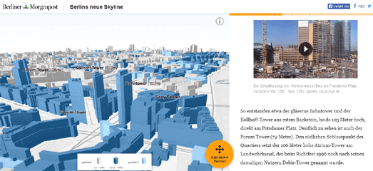
Berlin's neue Skyline is yet another super mapped visualization from the Berliner Morgenpost. This one uses 3d building data from OSM Buildings to create a story map exploring Berlin's growing skyline.
As you scroll down the page you can see how the center of Berlin has changed since 1990. The map spins and zooms into some of Berlin's new skyscrapers. The map sidebar also scrolls down to provide information on the building visualized in the current map view (the text is in German but the map still works if you view the page in Google Translate).

The Berliner Morgenpost's map was inspired by the New York Times' Reshaping New York. Reshaping New York looks at how New York changed in the first 12 years of Michael Bloomberg's reign as mayor.
The interactive centers around an impressively large 3d map of the entire city. As the user scrolls down the page the 3d map moves and zooms into the areas of the city that saw the most change during Bloomberg's term of office.
Each of these locations is accompanied by analysis from the New York Times and before and after photographs of the development that had taken place during the 12 years covered by the map.


Comments