Tuesday, December 31, 2019

The 2019 Map of the Year


During December the Maps Mania team usually spends many hours debating which were our favorite maps of the year. This year the choice was very easy. In 2019 there was only one real contender.

The 2019 Maps Mania Map of the Year is Donald Trump's Sharpie-gate Map.

On Sunday September 1st Donald Trump Tweeted that Alabama was in danger from the approach of Hurricane Dorian. Fortunately for the citizens of Alabama, and embarrassingly for the President, Alabama was not on the projected path of the hurricane.

When the error was pointed out to the President he took a really weird, but entirely within character, decision. Rather than admit to being wrong Donald Trump doubled down on his mistake. On Thursday August 29th the President called a White House briefing. In this briefing Donald Trump held up a NOAA hurricane advisory map showing Dorian's five-day forecast path into Florida. On this official NOAA map the President, or one of his employees, had drawn with a Sharpie an additional cone which extended into Alabama.

The NOAA map shows in white the hurricane's five day cone of uncertainty. With a black Sharpie line the President's map includes a cone of imbecility - the area that the impeached President Trump mistakenly warned was in the path of Hurricane Dorian.

There are a lot of pious gatekeepers in cartography. People who believe that amateurs really shouldn't mess with GIS without knowing at least some of the basic rules of cartography. Over the last 14 years Maps Mania has taken a more inclusive approach and has championed the work of amateur cartographers. If anything this blog is a celebration of maps created by individuals who often have very little formal training in cartography.

Maps Mania will always support the rights of idiots to make maps. In that spirit we are proud to award Donald Trump the award of Idiot Cartographer of the Year.

You might not like Donald Trump's map but the 2019 Sharpie-gate map is an almost perfect metaphor for this idiot's term of office. It perfectly encapsulates Trump's inability to listen to experts. His tendency to then make childlike mistakes. His refusal to then admit to these mistakes. And finally his amateur and often moronic attempts to cover up those mistakes.

Unfortunately for the people of America, in the paragraph above, you can also substitute the word 'crimes' for 'mistakes'.

If you want to finish 2019 by looking at some good maps then you might like Mapbox's round-up of 19 Amazing Maps from 2019. If you want to view some great maps without the Mapbox bias then you might also like Cartonerds's Favourite Maps from 2019. Cartonerd's list includes the work of Eleanor Lutz, who would I suspect be many people's Cartographer of the Year 2019.

2020 is Conquering the Earth


You can watch 2020 sweep across the world on the New Year Map. As time progresses today the New Year Map will become grayer and grayer as parts of the world move into 2020.

The new decade will first arrive in Polynesia. As time progresses today the New Year will move westward around the globe. New Year will arrive in Hawaii around 24 hours after it first arrives in Polynesia. You can use the New Year Map at any time today to see which countries across the world are already experiencing 2020 and which countries are still in 2019.

If you hover over a city on the map you can view the current local time and how much time is left until the city moves into New Year. Hovering over the map will also reveal the timezone of your selected location - highlighted on the map in gray. If you click on a city's red marker you can view a New Year's Countdown for the selected city.

Monday, December 30, 2019

Mapping American Poverty


There are 42,500,000 people in the United States living in poverty. Economic instability is now a matter of course for many Americans. In fact 40% of Americans would be unable to come up with $400 in an emergency. Microsoft News has partnered with Spotlight on Poverty and Opportunity to explore the economic hardship which is now confronting millions of Americans.

As part of this series on poverty Microsoft has released the Poverty Next Door interactive map. Every county on the Poverty By State and County map is colored to show the numbers of people living in poverty. If you select a state from the map's drop-down menu you can view the median household income in the state and the numbers living in poverty. If you select a county you can also view the local median household income and the number of people in the county living in poverty.

When you select a county on the map you can view a list of local charities working with people in poverty. Microsoft's interactive poverty map is part of its Poverty Next Door series, exploring economic inequality in modern America.

The Mercator Map of the Arctic


I predict that in 2020 we are going to see a lot of maps of the Arctic. It seems almost certain that the worsening global climate crisis will lead to an abundance of new maps visualizing the increasing loss of sea ice in the Arctic and Antarctic. It seems somehow appropriate then to end 2019 with an interactive version of the world's oldest separately printed map of the Arctic region.

Gerard Mercator's Septentrionalium Terrarum Descriptio is map of the Arctic, which was first published in 1595. Mercator's 1595 View of the Arctic is an annotated interactive presentation of the original map.

Mercator's map of the Arctic is not entirely accurate. It was plotted using contemporary discoveries but also uses myths and hearsay to fill in the gaps in real knowledge. For example the map shows the location of a race of "Pygmies, at most 4 feet tall", living in the Arctic. The map also seems to rely heavily on Inventio Fortunata, the travelogue of a Franciscan friar, which described the North Pole as a magnetic island surrounded by a giant whirlpool.

The map also includes the location of a very northerly California and, in one of the map's roundels, a depiction of the phantom island of Frisland.

The American Geophysical Union has released a much more modern map of the Arctic. Their new time-lapse video shows the extent of ocean ice in the Arctic over the past 35 years.


The video shows the age of Arctic sea ice between 1984 and 2019. It provides a stark visualization of the effects of global heating on sea ice in the Arctic region. Be prepared to see many more maps like this in the coming decade.

Sunday, December 29, 2019

The Butterfly Map


Butterflies is a Leaflet powered map which allows you to explore images of butterflies from the Natural History Museum's digital records. The map shows over 150,000 butterflies which have been organized, classified and mapped using deep learning.

The butterflies have been classified and mapped using the t-SNE machine learning algorithm for visualization. This type of machine learning algorithm maps similar objects closely together and dissimilar objects further apart. Interestingly the taxonomy developed by the algorithm closely matches the biological genus of the butterflies.

If you click on the image of a butterfly on the map then an information window opens showing the original Natural History Museum digital record and its classification and Latin name. You can learn more about how the map was made on Visualizing 150000 Butterflies From the Natural History Museum. This blog post also includes an image of the map with scientific labels showing the genus names of the clustered butterfly families.


The Butterflies map isn't the first time that the Leaflet mapping platform has been used to map small winged insects. British photographer Levon Biss has used the Leaflet mapping library to present close-up photographs of insects. His Microsculpture allows you to view high resolution photos of insect specimens from Oxford University Museum of Natural History in exquisitely fine detail using the Leaflet zooming and panning tools.

Each insect's completed image map consists of around 8,000 individual photographs (the large scale photographic prints are up to 3m high), captured using optical microscopes. The Leaflet mapping library really allows the user to fully explore these high resolution photos by zooming in close on the insects. The map scale in the top right-hand corner of the map provides a useful guide to the size of the insects as you zoom in & out on the images.


And it isn't only insects which can be found on Leaflet maps. Back in 2016 Cornell Lab created a beautiful Wall of Birds interactive map of a photograph of the wall mural in the Cornell Lab's Visitor Center.

Cornell Lab hired artist Jane Kim to paint a huge mural of birds on the largest wall in the Cornell Lab’s Visitor Center. The mural depicts species from all surviving bird families on a map of the world. Each of the 243 birds featured in the mural is painted on the map in a country where that species can be found.

The Leaflet powered map of the mural not only allows you to explore the exquisite detail in Jane Kim's painting it also allows you to learn more about each of the featured species of bird. Click on a bird on the map and a side panel opens with information on the selected species. You can even hear the song of each bird by clicking on the embedded audio recording from the Macaulay Library.

Saturday, December 28, 2019

The Martian Joy-Plot Maker


Last week the wonderful Peak Map was released. Peak Map is a fantastic interactive map which can create a joy-plot map for any location on Earth. Now, thanks to Peaks on Mars, we can make our very own joy-plot maps of Mars.

Peaks on Mars is an elevation map of Mars. The map uses a NASA digital elevation model to show the relative height and depth of Mars' canyons, mountains and canyons. It also includes the option to create a joy-plot map of any location on Mars. To create your own joy-plot map of Mars you just need to center Peaks on Mars on any location on the red planet and the map will automatically create a very artistic elevation profile of your chosen location.

Joy-plots (or ridgeline plots as they are sometimes called) are inspired by Joy Division's famous album cover for their Unknown Pleasures record. The Peter Saville designed cover for Unknown Pleasures has become a much loved iconic image. His cover design was inspired by a visualization of the radio waves emitted by a pulsar, which was published in the Cambridge Encyclopaedia of Astronomy. In data science a visualization which is inspired by this radio waves graph is often called a 'joy-plot' in acknowledgement of Saville's iconic album cover for Unknown Pleasures.

Tuesday, December 24, 2019

The Santa Tracker


Santa has begun has begun work on his busiest day of the year. This year you can follow Santa's journey around the world, as he delivers presents to all the world's children, on both the Google Santa Tracker and the NORAD Santa Tracker.

Google uses GPS (the Gnome Positioning System) to track Santa's sleigh as it travels around the globe on Christmas Eve. They then plot his movements around the world on a real-time Google Map. While following Santa on the Google Santa Tracker you can keep an eye on the sleigh dashboard to see how much time is remaining until Santa arrives at your chimney.

You can also follow Santa's progress this Christmas Eve on the Official NORAD Santa Tracker. Every Christmas NORAD's geo-synchronous satellites use the heat signature from Rudolph's red nose to track Santa's sleigh as it delivers presents to children around the world. While following along with Santa's global journey you can listen to a selection of Christmas songs, played by the US Air Force Academy Band.

Monday, December 23, 2019

Surfing While Balmoral Burns


Two maps have dominated my Twitter timeline over the weekend. One (shown above) was a screenshot of MyFireWatch, an interactive map of Australian bushfires. The other (shown below), from the Australia Bureau of Meteorology, reveals the record breaking temperatures the country has been experiencing this summer.


The climate-change denying Prime Minister, Scott Morrison, has come in for huge amounts of criticism after taking his family on vacation to Hawaii during what is seen by many as a national emergency.


The bushfire season in Australia has been very extreme this year. It has also been exhaustively long. The NASA satellite images above show bushfires burning in southeastern Australia in September and December. The satellite image on the left was captured on September 12, 2019 and the satellite image on the right is from December 4th, 2019. After four months of severe bushfires there is still no end in sight.

Last week Australia experienced its two hottest days on record. On Tuesday a record temperature of 40.9C was recorded. This record was then broken the very next day when a temperature of 41.9C (107.4F) was recorded. The extreme heat, strong dry winds and lack of rain are proving disastrous for those threatened by the bushfires. Meteorologists currently expect no significant rainfall in Australia for at least the next two months. The fire season in southeast Australia tends to be most severe during summer and autumn (December–March).

Saturday, December 21, 2019

The Bay Area Housing Calculator


The Mercury News has created an interactive map which shows you where you can afford to rent or buy a property in the Bay Area based on your annual income. The Housing Calculator uses data from Zillow to map the median rental and mortgage costs in each zip code area. The map reveals that unless you earn more than the median wage it is almost impossible to afford to live in the Bay Area.

If you earn less than $66,000 a year then you can forget about renting affordable property anywhere in the Bay Area. If you earn $66,000 a year then you can just about afford the median rent in Fairfield in Solano County. The cheapest place to buy a property is in Rio Vista, also in Solano County. In Rio Vista you will need to earn at least $57,200 to afford the median mortgage payment in the area.

For the purposes of this map properties are deemed affordable if the homeowner or renter is able to spend 30% or less of their gross monthly income on the mortgage or rent.


The Housing Calculator has been created as part of Mercury News' ongoing investigation of rising housing costs in the Bay Area, The Price we Pay. This three part series examines how the housing crisis is turning the Bay Area into an unaffordable area to live for all but those who earn significantly more than the median wage.

A Weiße Christmas


When Did You Last Have a White Christmas is a fantastic visualization of Germany's historical winter snow data. The visualization uses small multiples to show all the white Christmases at different German locations in the past 71 years.

When Did You Last Have a White Christmas doesn't involve any maps but it does use location data. If you enter the name of a German town or city the application will create a fantastic poster showing which years at that location had snow at Christmas since 1948. The visualization uses small multiples of different colored Christmas trees to show years which had snow, one day of snow or snow every day over the Christmas period.

You can download your town's Christmas snow visualization as a PDF file. This means that you can print out your own White Christmas visualization as a poster or even to use as wrapping paper for your Christmas presents.

Friday, December 20, 2019

The Spy in Your Pocket


The New York Times has been given a huge data file which holds more than 50 billion location records from the phones of more than 12 million Americans. This file helps to reveal how dozens of companies are using mobile phones apps to track the movements of people during the course of their everyday lives.

The NYT's article, Twelve Million Phones, One Dataset, Zero Privacy, is superbly illustrated with a number of maps. These maps help to illustrate both the huge number of people whose locations are being tracked and the huge amount of location data which is being tracked for each and every person who owns a mobile phone. The Times animates location data on top of satellite images of a number of locations to show the scale of the location tracking which is taking place. As the data is added these images become completely obscured, perfectly illustrating the ubiquity of how many people are being tracked by their phones and how phone owners are being tracked almost everywhere they go.

Many mobile phone apps insist that their tracking data is completely anonymous and that individuals can not be identified from their location data. The NYT shows how this claim is completely spurious and how easy it is to identify individuals from tracking data. Home and work locations are very easy to identify in most individual's mapped data and from there it isn't difficult to establish the identity of any individual.

The Times article includes a satellite map of Manhattan overlaid with the location of just one individual (the data is obscured to protect the real identity of the person). This image shows how by connecting all the individual location pings you can reveal a diary of a person's life. The image illustrates just how easy it can be to identify an individual from the patterns of their daily movements.

100 Years of Motorways


London's Victoria & Albert Museum has released an interactive map which plots the development of Europe's motorway network over the last 100 years. In 1924 Italy opened the world's first motorway. As you progress through the Evolution of European Motorways 1920-2020 you can observe how Europe's vast high-speed road network developed from that first stretch of the Autostrada dei Laghi in northern Italy.

In the first few decades of motorway construction Germany led the way in developing a national network of high speed roads. It was only in the 1960's that most other European countries started to build their own motorway networks. For example the UK's first motorway, the Preston By-Pass, wasn't constructed until 1958. As you progress through the V&A's motorway map you can click on the 'read more' buttons to learn about some of the more significant sections of motorway built in Europe over the last century.

The V&A's map ends by plotting out the route of the planned Russia Meridian highway. This very long new highway will eventually form part of a proposed massive inter-continental Russia-China highway. Once the Russia-China highway is completed you will be able to drive over 8,000 km on motorways from Portugal to the east coast of China.

Thursday, December 19, 2019

The Fabulous Joy Plot Map Maker


The Arun Valley in the South Downs National Park, England

Peak Map is a fantastic interactive map which can create a joy-plot map for any location on Earth. To create your own joy-plot map you just need to center Peak Map on your chosen location and a very artistic elevation profile will be generated automatically by this brilliant map.

Joy-plots (or ridgeline plots as they are sometimes called) are inspired by Joy Division's famous album cover for their Unknown Pleasures record. Since the 1970's the Peter Saville designed cover for Unknown Pleasures has become an iconic image. The original cover was inspired by a visualization of the radio waves emitted by a pulsar, which was published in the Cambridge Encyclopaedia of Astronomy. In data science a visualization which is inspired by this radio waves graph is often called a 'joy-plot' in acknowledgement of the iconic album cover. Over the years a number of maps have used ridgeline plots or joy-plots to visualize different types of data, often to show population density or to visualize elevation.

Peak Map includes a number of options which allow you to change the appearance of your generated joy-plot. The automatic setting draws black lines on a white background but you can choose your own background and line colors (my example above flips the default to show white lines on a black background). You can also change the height scale and smoothness of the elevation lines on your joy plot map and even reduce the joy plot map's opacity to reveal a labelled map beneath.

You can view some examples of joyplots being used to visualize mapped data on Maps Will Tear Us Apart Again.

This Map Writes Poetry


OpenStreetMap Haiku is a clever map that can write you a personal poem based on your current location. Share your location with OpenStreetMap Haiku and it will generate a unique ode using data gleaned from OpenStreetMap.

For example I shared my current location in east London with OpenStreetMap Haiku and it wrote this very apt poem for me:

Burford Road 
In this empty place
That's how it is in England!

The poems generated by the map can be a bit hit and miss. Not all of the poems are as good (or as accurate) as the poem generated for me about Burford Road.

The map works by querying the Overpass API to find points of interest on OpenStreetMap near your current location. A poem is then randomly assembled using the information it knows about your shared location. For example if I move the map a little to the east from Burford Rd, near to a local primary school, OpenStreetMap Haiku gives me:

By the school gate
The blur of lifetimes
bid good morning

I've obviously oversimplified how OpenStreetMap Haiku works. If you want more details about how the map generates poems based on different locations then you should read the author's explanation, OpenStreetMap Haiku: Using OSM and Overpass for Generative Poetry.

If you want to find poems about places written by real life human poets then you might also like the Poetry Atlas. The Poetry Atlas is an interactive map of poems written by established poets about locations around the globe.

Wednesday, December 18, 2019

Constellations of Hope


Alyssa Flowers has created a number of constellation maps which show which areas of the USA have been protesting the most since the inauguration of Donald Trump. Since Donald Trump became president there have been over 20,000 protests across the country. These protests have been held for a number of reasons, including for women's rights, to tighten gun laws and to protest Trump's anti-immigration measures.

Points of Light: Protest in America uses data on the number of public protests held across the country to link locations which have protested the most over the same political issues and at the same time. For example the constellation map of gun violence demonstrations shows that Florida, Richmond VA, Boulder CO and Santa Rosa CA have all seen numerous protests against gun violence and gun legislation.

Points of Light: Protest in America includes an animated map which shows the locations of protests across the country for every week since the inauguration of Donald Trump. It also includes a timeline and graphs showing the number and type of protests which have occurred during Trump's term of office. These visualizations help to explain when and why different types of protest have happened and what events may have triggered these protests.

The data for Points of Light comes from Count Love's tracking of protests. Count Love crawls local newspaper and television sites to track where political protests are taking place in the United States. The Count Love site includes an interactive map which shows the locations of all the protests which have occurred in the USA since January 20th 2017. This map can be filtered to view specific types of protest, for example civil rights, immigration or gun legislation.

Mapping the Exodus of Egypt


MosesTrek is an interactive map which plots the Biblical journey of Moses and the people of Israel from Egypt to Palestine. As you progress through the map you can follow the journey of the Israelites on their exodus of Egypt based on the account given in one of the oldest German-language Bibles from the 15th century. MosesTrek also uses information used in vintage 19th century maps and illustrations.

One of the two main vintage maps used as a basis for MosesTrek is the 1840 Map of the Promised Land (printed in Rostock around 1830), which is a map of "the 40-year journey of the children of Israel according to the scriptures". The other main historical map used is the Map of the Nile Delta to Palestine, (printed in London in 1848), which includes a plot of the "Israelite train from Egypt to Canaan".

Where the actual locations mentioned in the Bible aren't definitively known MosesTrek points to plausible locations. For example the real location of Mount Sinai (where God gave Moses the Ten Commandments) is not known so MosesTrek identifies locations which are plausible based on the Biblical story and timeline. MosesTrek also points to the locations which were identified as Mount Sinai in the German and English vintage historical maps of the Exodus.

MosesTrek is in German. However, the map works well with Chrome's 'translate this page' option. The map is also fairly easy to follow even if you have only a little familiarity with the story of Moses' journey.

How to Be Big in Switzerland


If you want to be a pop star in Switzerland then you should sing in Spanish. The top 2 most listened to musical artists in Switzerland are J.Balvin and Ozuna (in that order), both of whom sing in Spanish. About the worst thing you can do if you want to be big in Switzerland is sing in English. Of the top 10 most listened to artists only Lady Gaga and Ed Sheeran sing in English - and they both come way down the top 10 list at 8 and 9 respectively.

24 Heures has analyzed the most listened to artists on YouTube by French speaking people in Switzerland. In What Music Do the Romande Listen to the Most? 24 Heures has mapped the popularity of the 20 most listened to artists in French-speaking Switzerland. For each artist 24 Heures has mapped out their popularity (based on YouTube hits) in each region of the country.

The maps reveal that there is definitely a language and geographical element to the popularity of artists across Switzerland. Perhaps unsurprisingly French speaking artists are generally much more popular in the French speaking regions of Switzerland. In fact some of the French artists on the top 20 list appear to have almost no fans in non-French speaking areas of the country. Conversely German speaking artists are popular in German speaking regions and much less popular in the western French speaking part of the country. English and Spanish speaking artists seem to have a more universal appeal than French and German speaking artists and tend to be popular in both English and French speaking regions (although a few of the Spanish speaking artists seem to be only popular in very specific regions of Switzerland).

Tuesday, December 17, 2019

Who Lives Longest?


According to the latest data from the United Nations Japanese people have the longest life expectancy on the planet. In 2019 the life expectancy in Japan is 85 years. That means the average Japanese person can expect to live 32 years longer that the average person in the Central African Republic. In 2019 the life expectancy in the Central African Republic is 53 years, the lowest life expectancy of any country.

Our World in Data has created an interactive map which shows the life expectancy of countries around the world, based on data from James C. Riley, Clio Infra and the United Nations Population Division. Mouse-over a country on the Life Expectancy map and you can view the current life expectancy in that country.

As well as showing the latest life expectancy for people in countries around the world the Life Expectancy map allows you to see how life expectancy has changed over time. If you use the timeline control beneath the map you can view life expectancy around the world for any year since 1543. For example in 1880 the life expectancy in the USA was 39.4 years. In 2019 it is 78.9 years. If you select the chart option you can view a line graph showing how life expectancy has changed in different countries over time.


Mapipedia's Average Life Expectancy by Country since 1800 is another interesting data visualization of life expectancy around the world. This interactive map shows how life expectancy has changed around the globe since the beginning of the Nineteenth Century and also attempts to explain the reasons behind some of the most significant changes in life expectancy during this period of history.

If you select a country on the Mapipedia map you can view a list of historical events that have probably effected the average life expectancy of the population in the chosen country. For example if you click on Russia the 'Description' column will include information about World War I, Spanish Flu, the Soviet Famine, World War II and Russian Alcohol Consumption (1990-2001).

Select a country on the map and you can view a graph showing the average life expectancy in that country from 1800-2018. This graph is interactive. If there are any significant falls in life expectancy shown on the graph you can click on the chart to find out why these occurred. For example, using the example of Russia again, the graph shows a steep decline in life expectancy starting in 1940. If you hover over this data the 'Description' column provides information about the affect of World War II on life expectancy in Russia.

Yer aff tae lik' this map


The Scots Syntax Atlas is a freish interactive map whilk records th' different ways that scots fowk blether in th' different areas o' scootlund. Th' map includes sound recordings o' scots syntax whilk wur recorded o'er th' land. Th' map an' a' allows ye tae explore in whilk different areas o' th' land different types o' scots syntax ur spoken.

Tae create th' map th' researchers visited 145 communities in bonnie scotland interviewing local fowk 'n' recording thair answers. In thae interviews th' researchers wur particularly interested in syntax o' local dialects, in th' ways that sentences ur bult` up in th' different areas o' scootlund.

If ye click oan th' markers oan th' map ye kin listen tae interesting examples o' scots syntax whilk wur recorded in different bits o' th' land. Ye kin an' a' discover whaur thae different types o' scots syntax ur spoken by selecting th' "who says whit where" button. This option tae` shows ye whaur different types o' syntax ur spoken in bonnie scotland. Th' "stories behind th" examples' button provides a grammatical explanation o' th' recorded examples o' scotish syntax 'n' speirins oan howfur scots syntax differs fae mair 'standard' sassenach.

Translation

The Scots Syntax Atlas is a new interactive map which records the different ways that Scottish people talk in the different areas of Scotland. The map includes sound recordings of Scottish syntax which were recorded across the country. The map also allows you to explore in which different areas of the country different types of Scottish syntax are spoken.

To create the map the researchers visited 145 communities in Scotland interviewing local people and recording their answers. In these interviews the researchers were particularly interested in syntax of local dialects, in the ways that sentences are built up in the different areas of Scotland.

If you click on the markers on the map you can listen to interesting examples of Scottish syntax which were recorded in different parts of the country. You can also discover where these different types of Scottish syntax are spoken by selecting the 'who says what where' button. This option shows you where different types of syntax are spoken in Scotland. The 'stories behind the examples' button provides a grammatical explanation of the recorded examples of Scotish syntax and information on how Scottish syntax differs from more 'standard' English.

Monday, December 16, 2019

The Long Range Missile Map


If you've ever worried about whether North Korea's intercontinental ballistic missiles have a long enough range to target your home then you might like MISSILEMAP. Alex Wellerstein's MISSILEMAP is an interactive map which allows you to view the range of different nuclear and intercontinental ballistic missiles.

If you select a country from the drop-down menu you can view a list of that country's available long range weapons. Select a missile from this list and you can view its range overlaid on top of the interactive map. This allows you to see at a glance the theoretical capabilities and accuracy of the selected missile. If you select a target for your chosen missile the map will calculate the SSPK (Single Shot Probability of Kill). This is the probability that a single launch of the chosen missile will completely destroy a given target.


You can find out more about the likely effects of the missile on your chosen target by clicking on the export to NUKEMAP button. This will open up Alex Wellerstein's NUKEMAP with your chosen weapon and target automatically loaded.

NUKEMAP is an interactive map which visualizes the effects of different sized nuclear weapons. It allows you to see the fireball, airblast and radiation fallout extents of different nuclear weapons on any location in the world. The map can also calculate the estimated number of casualties for the selected nuclear weapon on your selected target. This estimation includes the expected number of fatalities and the expected number of injuries.

Both MISSILEMAP and NUKEMAP recently switched from Google Maps to Mapbox. Alex has written up a detailed explanation of why he made this switch on Why NUKEMAP isn't on Google Maps anymore. Most map developers will probably be well aware of the main reasons given for the switch, particularly the lack of development of the Google Maps API in recent years, coupled with Google's extortionate charges for using the Google Maps API.

UK Small Warming Maps


Last week German newspaper Zeit created an impressive small multiples visualization of global heating in Germany. Zeit's Too Warm Here uses 137 small colored maps of Germany to illustrate how the country has warmed since 1881. Each successive map is colored to show the average temperature in the country for that year.

I liked the visualization so much that I wanted to create a small multiples visualization of UK average temperatures over time. My UK Warming Maps is 50 small maps of the UK, each one colored to show the average temperature for each successive year from 1969-2018.


I'm not entirely happy with the results. I don't think 50 years is quite long enough to clearly see the pattern of rising temperatures in the UK. I would have liked to have made a visualization with at least a hundred maps to show rising temperatures over the last century. However I only had a few hours to make this visualization yesterday and I only got as far as creating 50 maps. When I have more time I might complete the whole 100 years.

I created the visualization using 50 SVG maps of the UK, with each map colored by the average annual temperature for that year. My UK Warming Maps uses average annual temperature data from the Met Office. The color scale works by coloring each year's map by how much the average temperature in that year was above or below the average mean temperature in the UK in the 50 years from 1969-2018. Despite only showing 50 years you can clearly see how the temperatures in the last 20 years have nearly all been over the 50 year average temperature for the UK.

If you want to create your own small multiples mapped visualization then you might like Webkid's Small Multiple Maps Using d3. Using d3 you could create a web visualization which is much more interactive than my static image. For example you could create a visualization which allowed you to click on the individual maps to reveal the average annual temperature for that year.

Saturday, December 14, 2019

The UK Election Interactive Maps


The BBC has created a scrollytelling map which provides a tour of what the BBC believes are the biggest stories in the 2019 UK election. These stories include the huge 365 seats by the Conservatives, Labour's loss of a number of traditionally left-leaning constituencies, the loss of the Lib Dem leader Jo Swinson's seat and the success of the SNP in Scotland.

The BBC's General election 2019: Animated tour in 10 stops provides an interesting tour of some of the important stories of this UK election. What it doesn't do is provide the user with the tools to analyze the results of this election for themselves. It is therefore a neat summary of the UK election but light on any detailed analysis.


The House of Commons library has created an interesting cartogram view of the UK election results. This map does provide a few filters which allow you to explore the results in a little more depth. The General Election 2019 Constituency Results cartogram groups constituencies by area. This not only allows users to easily navigate the cartogram it also provides an interesting insight into where each political party was most successful. For example it reveals quite clearly that the Labour Party (outside of London) has hardly any seats in the south of England.

The map also includes filters which allow you to see where male and female candidates were successful in this election and which seats were won by sitting candidates and where seats were won by new candidates. You can also filter the map to see where each political party made gains and losses.

One clear pattern which emerges on this map is the loss of Labour seats in its traditional heartlands of Wales, the Midlands and the north of England. However it wasn't only these seats which saw a swing from Labour to the Conservatives. The Times (paywall) created a swing arrow map which reveals this national swing to the Tories very clearly.


Even in the majority of seats won by the Labour Party there was an overall swing towards the Conservative Party. The major problem with this map is that it only looks at the swing between the Labour and Conservative Parties. Therefore this map isn't particularly useful in Scotland, where the main story appears to have been the uniform swing from all parties towards the SNP.

If you are interested in exploring the results of the 2019 UK election in more detail then you might also like the Economist's 2019 General Election map. The Economist's map includes a number of demographic filters which allow you to explore the results by age, income and population density. It also allows you to explore the results by the percentage who voted to Leave or Remain in the 2016 EU referendum.

Friday, December 13, 2019

It Was Brexit Wot Done It


A landslide victory for the Conservative Party in the 2019 UK election has already lead to lots of recrimination among left of center voters and politicians. Those on the left of the Labour Party are arguing that the voters didn't necessarily reject the party's left-wing policies. They are saying that the Conservative Party successfully cast this election as being about getting Brexit done.

Everyone else in the country appears to be blaming the Labour leader Jeremy Corbyn.

The Economist's 2019 General Election map allows us to explore the results of the 2019 UK election in more detail. In particular the map allows us to compare the 2019 election results with the results of the 2016 EU referendum results. The map shows that in the constituencies where the majority voted to leave the EU in 2016 the Conservatives won 291 seats and Labour won 105 seats. In the constituencies where the majority voted to remain in the EU the Conservative Party won 71 seats and the Labour Party won 95. The Liberal Democrat Party also won 10 out of their 11 seats in constituencies which voted to remain in the EU. There does therefore seem to be some support for the idea that Brexit was a major factor in how people voted in this election.


The BBC has released an interactive 2019 Election map which shows all the constituencies which have switched party since the last election. This map includes a neat hexagon view (using Esri hexagons) which reveals how the Conservative Party managed to pick up a lot of new seats in the north of England, the midlands and north Wales.

The six new seats which the Conservative Party won in Wales were all Labour seats in 2017. All six seats also supported leave in the 2016 EU referendum. In the Midlands the Conservatives picked up Wolverhampton SW, Wolverhampton NE, West Brom W, West Brom E and Dudley North, all from the Labour Party. Again all five of these constituencies voted to leave in the EU referendum. The same pattern seems to hold up in the North of England where the Conservative Party also picked up a number of seats from Labour in areas which voted to leave in the 2016 EU referendum.

The Labour Party only managed to win one new seat in the whole of the UK. This was the previously Conservative seat of Putney. In the 2016 EU referendum Putney voted to remain in the EU. It is therefore clear that in the 2019 UK election the Conservative Party were very successful in winning Brexit supporting seats which in the past normally vote Labour. Conversely the Labour Party were unable to win over traditional Conservative seats which voted to Remain in 2016.

The Economist's map also allows us to explore what demographic factors were at play in the 2019 UK election. Age is one of the biggest demographic factors which effect the results of most UK elections. It was no different in 2019. In the constituencies where over 65s make up more than 30% of the population the Conservatives won 79 seats and Labour won 3. Conversely in the constituencies where 16-34 year olds make up over 40% of the population Labour won 46 seats compared to the Conservatives 4 seats. Another huge demographic factor which played a part in this election was population density. In the least densely populated constituencies, where population density is between 10 and 1,012 people per square mile, the Conservative Party won 163 seats and the Labour Party won 9. In the most densely constituencies, where population density is between 9,656 and 50,000 people per square mile, the Conservative Party won 23 seats and the Labour Party won 90 seats.

The popularity of the Labour leader Jeremy Corbyn is a lot harder to quantify. The YouGov polling company's Public Figure tracker says that 61% of the UK public has a negative opinion of Jeremy Corbyn. This is compared to 47% of the population having a negative opinion of the Conservative leader Boris Johnson. When asked who would make the best Prime Minister the contrast is just as great. In November (according to a YouGov poll) 41% of the population said Boris Johnson would make a better Prime Minister and only 22% said Jeremy Corbyn.

It could well be that it was a combination of 'getting Brexit done' and the unpopularity of the Labour leader that cost Labour this election. What ever the reasons for the huge Conservative win Jeremy Corbyn has already said that he won't be leading the Labour Party in the next election. It remains to be seen if a new leader will move the Labour Party towards the middle-ground of UK politics. Clearly the party has a lot to do to win the votes of older and more rural voters.

Thursday, December 12, 2019

How Big Are the Bushfires? Part Two


Last week the Guardian created a simple visualization showing the size of the Australian bushfires. The How big are the fires burning on the east coast of Australia? is a very simple map which consists of a square polygon overlaid on New York, Paris, London and a number of Australian cities. While the map is an effective visualization it is not exactly visually compelling.

This week Reuters has released a more interesting visualization of the current bushfires burning in Queensland and New South Wales. In How a Mega Fire Spread Towards Sydney Reuters has created an animated map which shows the spread of the New South Wales bushfires from October until December 8th. The area which has been consumed by the fire in that time is truly shocking.

Non-Australians, unfamiliar with the size of the country, may not truly appreciate the size of the New South Wales bushfires. Reuters has therefore created a very simple visualization of the Gospers Mountain and Carrai Creek fires, represented as scaled squares. These two squares are placed next to a third, much smaller, square representing the size of California's largest ever wildfire. A small outline map of Manhattan Island provides further context to the astonishing size of the Australian bushfires.

Mapping the History of Luxembourg


Luxatlas is an interactive map which visualizes the urban development of Luxembourg since the beginning of the 19th century. The atlas uses a number of historical vintage maps to explore the city's growth and development from an early 19th century fortress city to a large-scale, international metropolis of the 21st century.

Using Luxatlas you can explore how Luxembourg has changed over time by viewing a number of vintage maps dating from the 1820's right up to the modern day. You can also explore the history of the city by overlaying a number of historical layers on top of an OpenStreetMap view of the present city. These historical layers include the footprint of the fortress, historical buildings and important historical infrastructure. You can even click on individual buildings on the map to view information and photos of these historically important sites.

Luxatlas includes a history layer which provides information on the city's development over time. This layer includes potted histories of some of the most important eras in Luxembourg's development. These include an account of the city before the 16th century fortress was constructed, the period from the fortress' construction until its demolition in 1867 and the city's urban development up to the 1960's & its development since the 60's.

Luxatlas is a collaboration between the University of Luxembourg and the Luxembourg City History Museum. The project is ongoing and more maps, photographs, and historical information will be added to the site over the next two years.

Wednesday, December 11, 2019

A Pipeline to Global Warming


A controversial expansion project is set to triple Canada's Trans Mountain pipeline capacity when it is completed in 2022. The pipeline carries up to 300,000 barrels of crude and refined oil a day from Alberta to the coast of British Columbia. After expansion it will have the capacity to transport 890,000 barrels per day.

Al Jazeera traveled more than 2,000 km along the pipeline route. During this journey they interviewed indigenous land defenders, community leaders, legal experts and supporters of the project. You can explore the results of this Al Jazeera investigation on Nations Divided: Mapping Canada's Pipeline Battle. This scrollytelling interactive map follows the route of the Trans Mountain pipeline.

As you progress through this story map, traveling along the pipeline's route across Canada, you can read Al Jazeera's interviews with locals, environmentalists and supporters of the expansion project. Al Jazeera's interactive story map explains the history behind the Trans Mountain pipeline, the reasons why it is being expanded and why its expansion is so controversial. As well as the many interviews with people along the pipeline's route Al Jazeera's map includes photos, videos and custom made Street View panoramas of locations along the route.

Al Jazeera's Nations Divided map was created using Mapbox's new Scrollytelling Template. The Scrollytelling Template can help you create a scroll driven story map using the Mapbox GL mapping library.

Climate Stripe Maps


Climate Stripes are one of the most powerful tools to visualize global heating. A climate stripe visualization uses different colored stripes to show the annual average temperatures over time. If you want to know how global heating has effected temperatures in any German town you can now create  localized climate stripe visualizations using a new interactive tool.

Zeit's Too Warm Here allows you to generate the climate stripes for any German town. Just enter a location into the tool and it will create a climate stripe image which shows the average annual temperature in the town for every year since 1881. The images also informs you which was the coldest and hottest year (on average) in your selected town.

Zeit's Too Warm Here also includes a small multiple map visualization which shows how temperatures have changed in the whole of Germany over the last 137 years. In this visualization a small map of Germany is colored for every year since 1881 to show the average annual temperature. In 21 out of the last 22 years Germany has experienced hotter than average temperatures.

If you live outside of Germany you can still create your own climate stripes. The European Commission's ERA5 Explorer allows you to view historical climate data for cities around the world. Click on the map and you can explore a range of climate statistics showing how the climate has changed at the selected location over the last forty years. The map even generates climate stripes for your selected location.

You can also generate climate stripes for individual countries around the world (and for individual U.S. states) using #ShowYourStripes. Select a region and then a country from the drop-down menu on #ShowYourStripes and you can view and download an image showing how temperatures have risen over the last 100+ years at your selected location.

Tuesday, December 10, 2019

The World's Diplomatic Network Map


The USA operates hundreds of embassies and consulates across the globe. In fact the USA has the most extensive diplomatic network of any country in the world. You can explore this comprehensive network for yourself on the 2019 Lowy Institute's Global Diplomacy Index interactive map.

The Lowy Institute's Global Diplomacy Index ranks the diplomatic networks of all the G20, OECD and Asian countries by city, country and post type. The index ranks each of these countries based on factors such as the number of embassies and consulates each country operates across the globe. The Global Diplomacy Index Network Map allows you to view the diplomacy ranking of each of the countries featured in the index and to view the diplomatic networks of each country. If you select a country on the map you can see the locations of its diplomatic missions in each country across the globe.

The yellow dots on the map show cities around the world which have diplomatic embassies or consulates. Click on a city's dot and lines connect to the city showing every country with a diplomatic post in the city. For example if you click on Washington D.C. on the map you can view all the 59 countries around the world who maintain diplomatic posts in the city.

The 1st Santa Tracker of Xmas


Every year the Google Santa Tracker battles it out with the Official NORAD Santa Tracker to see who can best keep tabs on Santa's sled as it travels around the world bringing joy to the world's children.

It takes a very brave person to take on the combined might of NORAD and Google. However that hasn't stopped Colby Fayock from giving it a go. His Santa Tracker is an interactive map which visualizes Santa's route around the world on Christmas Eve. The Christmas present markers on the map show all of Santa's many scheduled stops across the globe. If you click on these markers you can actually view the accumulated total of presents that Santa delivers as he travels around the world. According to the map Santa will have delivered close to 8 billion presents by Christmas morning.

Colby Fayock's Santa Tracker map itself seems to be have been built primarily as a demo for the Gatsby JavaScript library, which is an open source framework based on React. It also uses what it calls Google's unofficial Santa Tracker API, which I assume is the list and order of locations around the world which Google uses in its own Santa Tracker.

Monday, December 09, 2019

The Noongar Place-Name Map


Gnarla Boodja Mili Mili (Our Country on Paper) is an interactive map of some of the original Noongar place-names for locations in what is now the Australian city of Perth. Perth itself is known as Boorlo or Burrell in the Noongar language. The map features the Noongar place-names for Noongar camping and hunting grounds, natural landmarks and sacred places.

The Noongar are the indigenous people of the south-west corner of Western Australia. The Noongar place-names used on Gnarla Boodja Mili Mili are displayed on top of a vintage map of Perth. This 1838 map by Alfred Hillman shows what was, at the time, the proposed layout for the city of Perth. This map includes many of the lakes and swamps that existed before they were drained for the city's construction.

If you click on a Noongar place-name on the map an information window opens with vintage photos of the location, a description of the landscape (before development) and a translation or explanation of the Noongar name for the area.


If you are interested in Aboriginal place-names then you might also like the Weemala map. This interactive map uses data from historical surveys undertaken by the Royal Anthropological Society of Australasia. This 100 year-old survey data includes information on Aboriginal place-names their locations and their meaning.

The Weemala map allows you to browse the surveys and letters of the Anthropological Society of Australasia Survey. Each time you open a survey page or letter in Weemala any indigenous place-names in the text are also geo-located on a Leaflet map. If you click on any of the locations marked on the map you can find out the aboriginal place-name's meaning in English.

Road Orientations and Street Directions


Last year Geoff Boeing's Comparing City Street Orientations proved to be a very popular visualization of the street patterns in 25 major American cities. Using a series of compass roses Geoff revealed that the majority of U.S. cities adhere to a fairly strict grid system of roads. He then compared the strict grid system of many U.S. cities to the more organic street patterns found in other cities around the world.

His City Street Orientations around the World visualization includes similar compass rose charts showing the street orientations of 25 cities across the globe. When you look at the street orientations of American cities side-by-side with some of the much older global cities you can see how older cities tend not to have the same strict grid cities of younger cities in the USA.


In many American cities the street grid system is often reflected in the names of the city's streets. For example in some cities you might find that all roads called 'Avenue' run north to south, while all roads called 'Street' run west to east (or vice versa depending on the city). It is possible to visualize this pattern very effectively with an interactive map and a radial chart. My Miami Streets map visualizes the directions of all roads called 'avenue' and 'street' in Miami.

On the map all roads named 'Avenue' are colored red and all roads named 'Street' are colored blue. Simply by looking at the map you can tell that streets and avenues run in distinctly different directions in Miami. The radial chart on top of the map visualizes this more explicitly, showing the overall orientation of all the streets and avenues in the current map view (move the map around and the radial chart will update to show the orientation of all streets and avenues in the current map view).


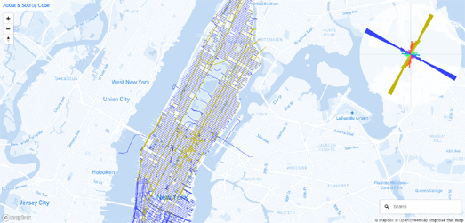
New York has a similar grid system to Miami. However in Manhattan the direction of the street grid system follows the directions of the Hudson and East Rivers, so in Manhattan streets and avenues are offset a little from the true cardinal directions. My New York Street Orientations map visualizes the directions of all roads called 'avenue' and 'street' in Manhattan. On this map all roads named 'Avenue' are colored gold and all roads named 'Street' are colored blue.


In both New York and Miami 'Avenues' run north-south and 'Streets' run west-east. This isn't true in every US city. You can see that in a new visualization by Data Stuff. Data Stuff's Street Network Orientation by Road Type visualizes the street orientations of many different road suffixes (including Avenues and Streets) in 25 U.S. cities. The visualization shows you the orientations of not only Streets and Avenues but also Drives, Boulevards, Roads, Terraces, Places, Courts and Ways.

You can see in this visualization how Streets and Avenues seem to be the two road suffixes which are most used in city grid systems. They tend to be the two types of road suffix which are used in the major roads in these grid systems. However Streets and Avenues don't follow the same directions in every city. As we saw earlier - in Manhattan and Miami 'Avenues' run north-south. Data Stuff's visualization shows us that in Atlanta, Cleveland, Denver and Las Vegas Avenues run west-east and in these cities 'Streets' run in the north-south direction.

America is Moving Up


Real-estate company Zillow argues that new residential construction in nearly all US metro areas consists of concentrated clusters of very large apartment buildings. Traditionally US cities have developed outwards with the development of new suburbs consisting of mainly single-family homes. However, Zillow says, that in recent years new residential construction has consisted almost entirely of concentrated clusters of apartment buildings in already developed areas.

In Islands of Density in a Sea of No Growth Zillow has used a series of interactive maps to show how this new pattern of residential construction is developing in America's major cities. On Zillow's maps census tracts are colored to show the mixture of housing type in a number of major cities. Single-family homes are colored blue and large apartment buildings are shown in red. The maps also include a menu which allows you to filter the buildings shown by building age.

This filter allows you to more easily identify the type of housing built in different decades. For example in Los Angeles if you select to view only buildings built before 2000 you can see that in the Twentieth Century single-family and small unit structures were the most popular residential construction types in nearly all of LA. If you then change the map to show only properties built after the year 2000 you can see that 50+ unit structures are now the most common type of new residential development. Which seems to support Zillow's argument that the US is now building almost exclusively islands of large apartment buildings in already developed areas.

Sunday, December 08, 2019

The UK Election Map


On Thursday the UK will be electing a new government. However we don't need to wait until Friday for the first interactive UK election map. In preparation for this week's general election the Economist has released a map which allows you to explore how a number of different demographic factors shaped the 2017 UK election.

The Economist's The political geography of the 2017 election allows you to visualize on an interactive map how different demographic factors, such as age, race and population density effect the results in individual UK constituencies. The map also allows you to explore the support for Brexit in each UK constituency, based on the 2016 EU referendum results.

One of the surprises in the last UK general election was the high youth turnout. In general young people overwhelmingly vote Labour. However traditionally turnout among the young is very low compared to the turnout of older voters, who tend to vote in large numbers for the Conservative Party. The unexpected large turnout of young voters in the last UK election is one of the main reasons the polling companies underestimated the Labour vote in 2017 (I believe that for the 2019 election all but one of the major polling companies have now changed their weightings towards respondent's self-declared voting intentions rather than weighting by age).

The Economist's interactive map includes two age filters. You can choose to see the seats won by the percentage of the population who are 16-34 years old. Alternatively you can choose to view the number of seats won by the percentage of the population over 65. Using these two filters you can explore for yourself how the age breakdown of the local population can have a drastic effect on the results in different constituencies.

Population density is another major demographic factor in voting intention. Like many other countries around the world rural electoral areas in the UK tend to vote more conservatively than urban constituencies. The Economist's map allows you to see the results of the 2017 UK election by the local population density. If you select a range on the population density slider and then drag it up and down to show constituencies with higher and lower population densities you can observe how the number of seats won by the Conservative Party goes down and the Labour Party seats rise as the map shows the more densely populated constituencies.

Saturday, December 07, 2019

How Big Are the Australian Bushfires?


The bushfires which are currently burning in eastern Australia have destroyed nearly 480 homes. According to the Guardian newspaper the combined size of the different bushfires is at least 2.2m hectares. To illustrate how big 2.2m hectares is the Guardian has created an interactive map which allows you to view 2.2m hectares overlaid on top of a number of global cities.

The How big are the fires burning on the east coast of Australia? interactive is a very simple map which consists of a square polygon overlaid on New York, Paris, London and a number of Australian cities. The map also includes the option to view the size of the total fires in both Queensland and New South Wales separately, as smaller squares overlaid on the same global cities.

The animated Gif above was made using imagery from the Himawari-8 satellite. The imagery consists of a number of satellite images, taken 10 minutes apart, which were captured between around midday and 4pm on 12th December.

Friday, December 06, 2019

Working Only for the Rent


The island of Sylt in the north of Germany is the most unaffordable place to rent a property in the whole of the country. If you are a low-incomer earner in Sylt then, on average, you will have to pay over half of your salary on rent. The most affordable municipality in Germany is Borgentreich, in the Höxter district of North Rhine-Westphalia. Low-income earners in Borgentreich on average only have to pay 18% of their salary on rent.

Two weeks ago Zeit released an interactive map of rental costs in Germany. Zeit's interactive map How Expensive is Living in Germany? visualized the average rent charged in towns across the whole country. On the map individual German municipalities were colored to show the average rental cost of properties by square meter. As part of its continuing examination of the rental market Zeit has now released a new interactive map which visualizes German rents as a percentage of the average income of a low-income earner.

Zeit's Rental Costs: Working Only for the Rent includes an interactive map which shows the cost of renting in 4,000 municipalities, based on the average rent as a percentage of the average low-income salary in the municipality. For the sake of the map low-income earners are defined as the 20 percent of the local population with the lowest salary. If you hover over an area on the map you can view the local average rent, the average local low-income salary and the percentage of this wage which would have to be paid for the average rent.

Zeit's article also includes three maps which show how much of their salaries low-income earners would have to pay for different priced rental properties. These three maps show the percentage of a low-income salary which would need to be spent on a low-cost rental property, an averagely priced rental, and an expensive rental. Obviously the burden increases with the cost of a property. In many cases a low-income worker would have to pay over 100% of their salary to be able to afford an average priced expensive rental property.