Skip to main content
Search
Search This Blog
Maps Mania
Posts
Showing posts from April, 2010
Show all
April 30, 2010
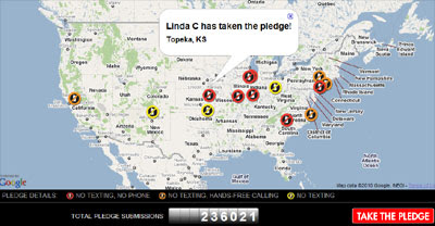
Mapping the 'No Phone Zone'
April 30, 2010
Create Collaborative Google Maps
April 30, 2010
Friday Fun with Google Maps
April 29, 2010
Live Tornado Action on Google Maps
April 29, 2010
Crime of Denmark on Google Maps
April 29, 2010
Finding Wildlife with Google Maps
April 29, 2010
Bulgarian Google Maps Mashups Roundup
April 29, 2010
The Stumble Upon for Google Maps
April 28, 2010
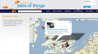
Tag the World
April 28, 2010
2010 California State Geologic Maps
April 28, 2010
Two More French Google Maps Mashups
April 28, 2010
Share Your Adventures with Google Maps
April 28, 2010
Finnish Google Maps Mashup Roundup
April 27, 2010
Berlin Travel Times on Google Maps
April 27, 2010
Creating Sound Gardens with Google Maps
April 27, 2010
Mapping the Trees of San Francisco
April 26, 2010
Google Earth Comes to Google Maps
April 26, 2010
Follow 4Chan on Google Maps
April 26, 2010
Create a Travel Guide with Google Maps
April 26, 2010
Mapping American Crime with Google Maps
April 26, 2010
Google Maps for MapInfo Professional
April 25, 2010
Jack the Twitter Tracked with Google Maps
April 24, 2010
The London Marathon on Google Maps
April 24, 2010
The Long Journey Home - Mapped
April 24, 2010
Hubble Telescope's 20th Anniversary
April 23, 2010
Videos of the World on Google Maps
April 23, 2010
Friday Fun with Google Maps
April 22, 2010
Google Maps Adds Kinetic Scrolling
April 22, 2010
Finding Restrooms with Google Maps
April 22, 2010
UK Election Twitter Maps
April 22, 2010
Moving from ArcGIS to Google Maps
April 21, 2010
Google Maps Adds Buzz Layer
April 21, 2010
Tracking Objects with Google Maps
April 21, 2010
Finding Concerts with Google Maps
April 21, 2010
On the Trail of a Rapist
April 21, 2010
Google Maps Navigation Now in the UK
April 21, 2010
Government Take Down Requests Map
Newer Posts
Older Posts
Home