Tuesday, April 30, 2019

The World in Globes


From observing the cyclical movements of the stars in the night sky Greek philosophers theorized that the Earth was at the center of a circular universe. Aristotle surmised from the circular shadow of the Earth on the Moon that our planet must also be a globe. At least one of those Greek theories was correct.

Humans have known for over 2,000 years that the Earth is round. We have also been representing the world as a sphere for much of that time. The National Library of France's Le Monde en Spheres explores the history of maps and globes. Starting 2,500 years ago BnF looks at the invention of the globe, its development by Islamic scientists, its rediscovery in the west during the renaissance and even how it is being reinterpreted in the digital age.


Le Monde en Spheres is entirely in French. Even if you don't read French and your browser can't translate the text it is still worth visiting just to view the interactive images of the historical maps and globes featured in Le Monde in Spheres. The site features many zoomable images of vintage maps and animated globes from Ptolomy to the Space Age.

Monday, April 29, 2019

Mapping White Return in the USA


The New York Times has explored census tracts across the United States and discovered a trend of white residents moving into traditional nonwhite neighborhoods. In The Neighborhood Is Mostly Black. The Home Buyers Are Mostly White the NYT maps out the neighborhoods where the white population has grown.

The NYT article includes a series of small maps showing how city centers are increasingly attracting new white residents, while traditional white dominated suburbs are becoming more diverse. Because of the history of redlining and years of under-funding in the USA inner-city neighborhoods are relatively cheap. In most other countries around the world city neighborhoods so close to downtown are among the most expensive places to live. It appears that many white Americans have woken up to the value of inner-city living. As with most gentrification this often comes at the expense of the traditional residents of these neighborhoods.

An interactive map is also included in the article which shows every census tract in the USA that has grown more diverse since 2000 (about one in three). The yellow census tracts on the map have seen a growth in the percentage of white residents. The blue census tracts have become more diverse. If you hover over the individual tracts you can view the mean income of all residents and the mean income of the new buyers in the area. In the blue census tracts the new non-white residents tend to have similar incomes to the older residents of the tracts. In the yellow census tracts the new white residents tend to have much larger incomes than the non-new homeowners.

The University of Minnesota recently released an interactive map which also looks at neighborhood change. American Neighborhood Change in the 21st Century: Gentrification and Decline visualizes which neighborhoods in the U.S. have seen economic decline and which have seen economic growth. The University of Minnesota study reveals that non-white Americans are far more likely to live in economically declining areas than white Americans. In 2016 only 9% of black Americans lived in economically expanding areas.

A Geography of Thrones Game


How well do you know A Game of Thrones?

You might be able to tell the difference between a White Walker and a Wildling but can you point to where the Wildling's most permanent settlement is on a map of Westeros? A new interactive map game from Carto will test how well you know the geography of Westeros and Essos?

Let's put your Ice & Fire knowledge to the test with the Geom of Thrones game. In this Game of Thrones map trivia game you need to identify locations on an unlabeled map of Westeros and Essos. For example you might be asked to identify the city who's chief export are bedslaves trained in 'The Way of Seven Sighs.' All you need to do is click on the location of the city on the interactive map.

Get a question right and you are awarded 100 points and you progress to the next question. Get a question wrong and you will have points deducted from your overall score. There are five questions in all.

If you want to create your own interactive Game of Thrones map game then you might want to have a look at Carto's Game of Thrones Basemap of the Seven Kingdoms. This Game of Thrones basemap layer provides a great canvas on which you can add all of your Games of Thrones geo-data.

The 2019 Spanish Election Maps


The centre-left Spanish Socialist Workers' Party (PSOE) have emerged as the main winners in yesterday's national election in Spain. The party took 28.7% and won the most seats (123 seats, an increase of 38 seats from 2016). The biggest losers were the corruption hit centre-right People's Party (PP), who lost about half of their voters. The PP only managed to win 66 seats (down from 135 seats in 2016).

You can explore the results for yourself on El Pais' 2019 General Election map. The map reveals that the PSOE were popular throughout much of the country and that the PP lost votes nearly everywhere, but most dramatically in the south and east of the country. The PP were the most successful party in the last election in 2016, however the party has been damaged by corruption scandals and by its handling of the Catalan independence issue.


Last week El Pais published an interactive map of the 2016 Spanish Election. The image above shows the 2016 (left) and 2019 (right) election maps side-by-side. This map clearly shows how the PP lost ground throughout central Spain and how the PSOE has spread from its traditional southern stronghold to capture most of Spain.

The fall of the centre-right PP also resulted in a rise in seats for the centre-right Citizens party and the far-right Vox party. The Citizens party won 57 seats (a rise of 25) and for the first time Vox picked up 24 seats (0 seats in 2016).

Despite the huge rise in support for the centre-left PSOE they still remain short of the 176 seats they need for a working majority. The party will therefore need to rely on the support of the Unidas Podemos party (42 seats) and some of the smaller regional and nationalist parties to form a government.


After the midterm U.S. elections last year many interactive maps used directional arrows to visualize the swing in votes towards either the Democrats or the Republicans. El Diaro has created a similar directional arrow map for the 2019 Spanish election which shows where Spain has moved to the left or right since the 2016 election.

If you click on the 'Por Bloques' tab above the El Diaro interactive map and then select the 'VariaciĆ³n sobre 2016' map you can view an arrow map showing where the vote swung left or right in this election. The map reveals a huge swing to left-wing parties in the north-west regions of Spain, along the Mediterranean coast and in Madrid. There seems to have been a swing to right-wing parties in the south of Spain, but these swings appear very small compared to the larger swing to the left elsewhere in Spain.


The only map I can find which provides a breakdown of where people voted for the extreme right Vox party is on Reddit. This map shows the percentage of votes cast for Vox in each constituency area (you can view the percentage of votes cast for all of the parties in each constituency on Wikipedia).

The two dots underneath Spain on the map are the two Spanish autonomous cities of Ceuta and Mililla, both of which are situated on the north coast of Africa. Cueta recorded the highest percentage (24%) of the electorate voting for Vox in the whole of Spain. Melilla recorded the fourth highest percentage vote (16.9%). Morocco believes that sovereignty of Ceuta and Melilla should be transferred to Morocco. This may be one reason why voters in the two cities voted in such high numbers for a nationalist party like Vox. Other constituencies which voted in higher percentages for Vox than the rest of Spain were: Alemeira (19.2%) and Murcia (18.6%) on the south-east coast, and Toledo (16.9%) and Guadalajara (16.5%) in the Castilla–La Mancha region of Spain.

The areas which showed the least support for Vox are all in the Basque Country and Catalonia. You could argue that voters there voted for their own Nationalist parties. However it is probably more accurate to say that Vox's opposition to Basque and Catalan autonomy proved particularly unpopular to voters in these two regions.

Saturday, April 27, 2019

No Planes Over Pakistan


FlightRadar24 has become the go-to source for mappers searching for flight data, particularly when something happens to disrupt air traffic around the world. Last month the New York Times used data from FlightRadar24 to visualize the grounding of Boeing 737's around the world after the crash of Flight 302. Now Reuters has used data from the same source to visualize How India-Pakistan tensions have disrupted air travel.

During the early hours of February 26 Indian warplanes flew into the Khyber Pakhtunkhwa province in Pakistan and dropped a number of bombs in the vicinity of the town of Balakot. India claimed that they had made a preemptive strike against a terrorist training camp. A claim which Pakistan disputes, saying that the bombs were dropped in an uninhabited area. The day after the Indian airstrike Pakistan cancelled all commercial flights and closed its airspace.

Reuters has used data from FlightRadar24 to create a number of maps showing how air travel in the region has been disrupted by Pakistan's closure of its airspace. These mapped visualizations include a series of small maps showing how a number of planes had to divert around Pakistan on the day that the airspace closure was announced. It also includes a larger map which provides a snapshot of flights on February 27, with a big absence of flights over Pakistan. A third map shows the flight paths of planes from April 3-9, most of them skirting around the southern tip of Pakistan.

Friday, April 26, 2019

Wicked Weather & Deadly Disasters


The Washington Post has mapped out the areas of the United States which have experienced the worst weather related disasters. In Mapping America’s wicked weather and deadly disasters the WaPo has published a series of maps which use historical weather data to show which parts of the country are most prone to tornadoes & hurricanes, floods, extreme heat & cold, wildfires, lightning, and earthquakes & volcanoes.

Most of you are probably already aware of the areas of the country which are most likely to be hit be hurricanes, tornadoes and earthquakes. These areas are already pretty well known. Hopefully you are also already aware of the local areas around you that are susceptible to flooding. You might not be so aware of the areas nationally which see the most floods (areas around the tributaries of the Missouri and Mississippi Rivers and 'Flash Flood Valley' in Texas).


Did you know that around 17 million lightning strikes flashed across American skies in 2018? According to the Post's map only a very small percentage of those lit up the skies in the west of the country. On the other hand Florida, in the extreme south east, is America's lightning rod. On average the state witnesses around 1.25 million lightning events every year.

At the end of the Washington Post article are a number of links to related stories on America's extreme weather events. These include stories on the $155 million cost of natural disasters this year and why you should prepare a natural disaster emergency plan.

Brussels - City of the World


Brussels has the second highest percentage of citizens who were born abroad of all the cities in the world, after Dubai. Around 60% of Brussels residents were not born in Brussels. You can discover where these residents born overseas originally came from on Karim Douieb's visualization of the Belgium capital's population.

Brussels - A Lovely Melting Pot is an impressive data visualization exploring the diverse composition of the population of Brussels. The visualization uses d3.js to seamlessly animate between a number of different charts and graphs exploring the origins of Brussels' residents. These charts and graphs show the percentage of citizens born overseas and which countries they were born in.

At the end of the visualization a series of dot maps reveal where the immigrants from different parts of the world live in the city. These maps reveal that citizens from different countries tend to live in distinct areas of the city. Around 10% of immigrants living in Brussels originate from North African countries. These residents tend to live mostly in the north-west of the city, particularly in the Anderlect, Sint-Jans-Molenbeek and Bockstael neighborhoods. Residents who emanate from EU15 countries (EU countries before the 1995 enlargement) are most densely concentrated in south central Brussels. It might not surprise you to learn that Anderlect, Sint-Jans-Molenbeek and Bockstael are among the most disadvantaged areas of Brussels.

Germany's Red Belt Area


The so called Black Belt region of the United States is an area cutting across the south east of the country. It is an area which is defined by the highest levels of slave ownership in the 19th century. Even though slavery was abolished in 1865 the legacy of slavery can still be observed in the stark levels of inequality in the region. It also apparent in how the region under performs in many different socio-economic areas compared to the rest of the United States.

Over 150 years after abolition the Black Belt area still often stands out on maps exploring socio-economic data in America. For example you can see the how the Black Belt area shows up prominently in maps as diverse as American mortality rates and IRS targeted areas.

Maps visualizing socio-economic data in Germany also often feature a prominent 'black belt' area. When looking at maps of socio-economic data in Germany the region which often stands out as being economically behind the rest of the country is the former East Germany. In Germany this area is not defined by slavery but by the border of the former German Democratic Republic. So perhaps we should call it Germany's 'red belt' area.

An example of this distinct 'red belt' area can be seen in yesterday's Hamburger Abendblatt. The newspaper released an interactive map of disposable income in Germany in which this 'red belt' is very apparent. On this choropleth map, showing Where Disposbale Income is Highest and Lowest, you can clearly see that on average Germans living in Brandenburg, Mecklenburg-Vorpommern, Saxony, Saxony-Anhalt, and Thuringia have less disposable income than Germans living in the former West Germany. On average people living in the former East Germany have around 84.7% of the disposable income of the average West German.


Back in 2014 Zeit Online, in German Unification: A Nation Divided, explored how the former East Germany 'remains visible in statistics'. Twenty Five years after the fall of the Berlin Wall the paper published German maps of average income, the average age, the number of children in day care and in many other areas. In nearly all of these maps you can clearly see that there is a marked difference between the former East and West Germany.

Over 150 years after its abolition the legacy of slavery is still causing huge levels of inequality in the USA. My guess is that Germans living in the area of the former German Democratic Republic won't be facing so many years of inequality. This is mainly because white Germans don't have to battle against institutionalized racism. In fact, if we go back to the Hamburger Abendblatt's map of disposable income, we can see how things might already be changing. The disposable income map of Germany includes a choropleth layer which visualizes the areas which have seen the biggest increases in disposable income since 2011. On this measurement East Germans are doing much better. According to the Hambureger Abendblatt "with an increase of around 13.9 percent, the increase in income in the East was above the national average".

Besides, as the Day Care map in the Zeit Online article suggests, former East Germany doesn't lag behind the former West Germany in every area. One reason why more children are in day care in the  East could be because women face less discrimination in these states than in West Germany. Back in March the Berliner Morgenpost mapped out Where women earn more than men in Germany. The Morgenpost's map reveals that the pay gap between men and women is not so bad for women living in the former East Germany as it is for women living in the west of the country. If you are a woman working in the former East Germany then you are much more likely to earn a similar wage to an East German man. Women who live in the west of Germany are more likely to earn a lot less than the men living in the west of the country.

Thursday, April 25, 2019

Exaggerated Relief Maps


Exaggerated relief maps can be fun to make. However they can also be time consuming to create. They normally require some serious GIS software, a digital elevation model and a lot of patience. Unless you have an interactive map to do all the work for you.

The Relief Map Viewer is a fun interactive tool which allows you to view an exaggerated raised relief map for any location in the world. Just use the search box to navigate to a location and the Relief Map Viewer will show you the location with the elevation data slightly exaggerated. This is achieved by overlaying satellite imagery on top of an exaggerated digital elevation model.


The Relief Map Viewer includes a number of tools which allow you to adjust the map settings. In the 'Map Settings' menu you can adjust the height multiplier, which allows you to exaggerate the elevation to an even greater extent than the default setting. This menu also allows you to zoom in and out on the map. The 'Lighting' menu allows you to adjust the intensity and direction of the lighting effect.

The map was created using the Mapbox SDK for Unity. Mapbox's SDK for Unity includes a global digital elevation model encoded in raster tiles. This is what allows the Relief Map Viewer to show an exaggerated relief map and to allow users to adjust the height multiplier on the fly.

Wednesday, April 24, 2019

How Global Warming Has Warmed Your Home


Buzzfeed has released two interactive maps which show how climate change is effecting locations across the globe. How Climate Change Has Already Transformed The Earth features two maps. One shows how temperatures have risen over the last 138 years. The other reveals how sea levels have risen since 1993.

The first interactive map visualizes the rate of global warming around the world since 1880. Click anywhere on the map and you can view a graph showing the changes to the average temperature at that location for the last 138 years. As well as creating a graph of temperatures over time the map includes a choropleth layer which reveals where temperatures have risen since 1950. This layer provides a stark illustration of how global warming has affected locations around the world, in particular in the Arctic. If you click on individual years on the interactive temperature graph you can see by how many degrees the temperature has risen at the selected location.


I've definitely written about the global warming map before on Maps Mania, however the map appears to have been updated since it last featured with the latest temperature records. The Buzzfeed article also features a new, similar styled, map which shows how sea levels have risen around the world. The choropleth layer on this map shows a comparison of the average sea level from 2008–2010 compared to the average from 1993–1995. The darker the shade of blue on the map then the higher the sea level rise. The graph shows the average global sea level for every year since 1993.

You can see how the two interactive maps were made (and how the Arctic sea ice animation in the Buzzfeed article was built) on the project's Github page. The maps were created with Mapbox GL and Highcharts (for the interactive graph).

The 2019 Spanish Election


Spain's general election will take place this Sunday (April 28th). All 350 seats in the Congress of Deputies are up for election, as well as 208 of the 266 seats in the Senate. Ahead of the election El Pais has released a detailed interactive map of the results from the 2016 Spanish Election. El Mapa del Voto en Toda Espana provides a stark illustration of the geographical strongholds of the main political parties.

The centre-right People's Party (PP) won the most votes in the 2016 election. The centre-left Spanish Socialist Workers' Party (PSOE) got the second most votes. As you can see on the map the PSOE performed well in the south of the country. They also performed well in the mining areas of Asturias. In the Basque region the Basque Nationalist Party (PNV) was the most popular political party. In Catalonia the Republican Left of Catalonia (ERC) was very popular. The left-wing Unidos Podemos (now Unidas Podemos) was the third most popular party nationally.

The new far-right Vox party didn't really feature in the 2016 election, so don't appear on the map. Vox may capture some votes from the People's Party this time around, mainly because  the PP have been hit in recent years by a number of corruption scandals. The emergence of the centre-right Citizens party may also have an impact on the People's Party. The polls predict that PSOE will win the most seats of all the parties but won't get an overall majority. They will be hoping that PP, Citizens and Vox don't get enough seats between them to form a coalition government.

Tuesday, April 23, 2019

Inequality in Australia


The Guardian has mapped out the percentage of people living in the most economically advantaged households and the number living in the most disadvantaged households in each Australian neighborhood.

The Guardian's Inequality in Australia interactive map use the experimental Index of Household Advantage and Disadvantage, which is in turn compiled from data from the 2016 Census of Population and Housing. The map has two different data layers. One shows the percentage of households living in the most disadvantaged group (the lowest quartile of the index). The other shows the percentage of households in the most advantaged group (the highest quartile of the index).

The Guardian hasn't provided much commentary alongside the map, except to say that the highest percentage of disadvantaged households are in remote and regional areas where a relatively "large proportion of the population is Indigenous". They also say that the areas with the most advantaged households are in inner metropolitan areas.


This static map (from Wikipedia) shows the number of Aboriginal Australians as a percentage of the population based on the 2011 census. Comparing the two maps there does seem to be a large percentage of households living in the most disadvantaged quartile in areas with a higher number of Aboriginal Australians as a percentage of the population.

Death on the Roads


Cars are now the biggest killers of people aged 5-29 around the world. Those deaths are from traffic injuries alone and don't take into account fatalities caused by air pollution. According to the World Health Organization 1.35 million people were killed in road traffic accidents in 2016. A disproportionate amount of those deaths were in developing countries.

There are large regional differences in the rate of road traffic deaths around the world. Europe has the lowest rate of road traffic deaths with 9.3 deaths per 100,000 population. The Americas have the second lowest regional rate with 15.6 deaths per 100,000 population. Africa and South-East Asia have the worst record for road traffic deaths with 26.6 and 20.7 deaths per 100,000 population respectively.

You can explore the rates of road traffic deaths in countries around the world on WHO's Death on the Roads interactive map. Select a country on the map and you can view its road accident death rate, the total number of road traffic deaths, and information of the selected country's road safety laws and vehicle standards.

The United States has a traffic death rate of 12.4 per 100,000 population and compares very unfavorably to most other countries with similar economies (Canada for example has a rate of 5.8 per 100,000). One reason for this is that the United States doesn't meet any of the World Health Organization's criteria for good road safety laws. The WHO rates every country on whether it has good laws for Drink-driving, Speed, Helmets, Seat-belts and Child seats. The United States doesn't rate as having good laws for any one of these individual areas of road safety.

Mapping China Tech Giants


The recent arrest of Huawei's Meng Wanzhou in Canada, at the request of the USA, has highlighted the growing tensions between China and the west over the ever growing influence of Chinese technological companies around the world. The west accuses these Chinese tech companies of continually stealing technology from western companies. It also has security concerns about Chinese technology being used in the west.

Chinese technology companies are playing a huge role in bringing modern technology to many previously unconnected areas, particularly in the developed world. This in turn worries many western governments who are concerned about the strategic and political implications of countries in the developing world being reliant on Chinese technological infrastructure.

The Australian Strategic Policy Institute has released an interactive map tracking the global reach of 12 key Chinese tech companies (including Huawei). Mapping China's Tech Giants shows the global influence and the global infrastructure being built by 12 of China's biggest technology companies. The interactive map includes the locations of undersea cables, 5G networks, data centers and manufacturing facilities. In total there are 17,000 data points shown on the map. This data can be filtered by technology type, by company and by individual company. If you click on the 'view companies' link in the map sidebar you can also view more details on the 12 individual Chinese tech companies featured on the map.

Providing technological support and infrastructure is just one way in which China is expanding its geo-politcal influence and global reach. China has also invested heavily in the physical infrastructure related to transport, energy and trade around the world. You can read more about China's global 'belt and road' initiatives in Understanding China's Belt and Road Project.

Monday, April 22, 2019

World Press Freedom 2019


The United States has fallen three places in the World Press Freedom Index since last year. Every year Reporters Without Borders rank the countries of the world based on an assessment of each country's record of supporting the freedom of the press. This year the United States is ranked 48th out of 180 countries, and the RWF say that the media climate in the U.S. is now “problematic”.

When President Trump took office the United States was ranked 41st of all the countries in the world. They have dropped down the list every year since Trump became President. Other countries to have fallen down the list this year are Venezuela (down five at 148th), Russia (down one place at 149th) and China (177th down one place). For the third year running Norway tops the list. Finland have moved up two places to come second in this year's index and Sweden are in third place overall.

You can find out where every country in the world ranks on the 2019 World Press Freedom Index interactive map. Countries on the map are colored based on their rankings. Countries colored a pale yellow are deemed 'satisfactory'. Countries colored orange are seen as 'problematic'. Red countries are in a 'difficult situation' and black countries are in a 'very difficult situation'.

The very pale yellow colored countries (which the RWF say are colored white) are classified as 'good'. This year 24% of the 180 countries ranked by Reporters Without Borders have qualified as 'good' in the index. Last year it was 26%. If you click on a country on the map you can read the score awarded by RWF and click on the 'read more' button to view the overall assessment of press freedom in the selected country.

Mega Monday Map Quiz


Can you name these three European cities?

The maps above show three different cities. To make the question harder each map only shows building footprints. All other features, such as roads, rivers and parks have been removed from the maps.

It isn't easy is it? 

How about if I told you the first city is in Switzerland, the second map shows a small section of a city in Germany, and the last map shows a section of a city in England.

Still stuck?

What if I tell you that one map is from Berlin, one is from London and the other Basel?

OK, so that isn't exactly a 'mega' map quiz. That's because each of those three circular maps comes from a different quiz. The first map comes from Tages Anzeiger's Do you recognize the Swiss city?. The second map comes from the Berliner Morgenpost's Do You Recognize the Area?. The third map comes from my own quiz London Squares, Markets & Circuses.

The first quiz, from the Swiss newspaper Tages Anzeiger, includes 12 maps of different cities in Switzerland. The second quiz, from the Berliner Morgenpost, includes 12 maps of different areas of Berlin. My quiz includes six maps of different areas of London. Now that's a bit more mega

All of these three quizzes were made with Hans Hack's Figuregrounder. Figuregrounder is a very easy to use tool which allows you to make map posters for any location in the world using OSM data. The posters are simple circular building footprint maps. So if you want to create your own map quiz you can just use Figuregrounder to make maps of different cities, towns or neighborhoods.


Alternatively you could use the Street Patterns tool for making map posters from city street patterns. Street Patterns is a very similar tool to Figuregrounder, except it uses data from OpenStreetMap to create maps from just streets and roads (instead of building footprints).

The image above shows street patterns found in Paris, London & New York. Can you guess which is which? The answer can be found here.

The Ukraine Presidential Election Map


A comedian has been voted the President of Ukraine. Volodymyr Zelenskiy, who plays the role of the president on a popular television comedy, is now the actual President of Ukraine, after cruising to victory in yesterday's presidential election in Ukraine.

Volodymyr Zelenskiy received an astonishing 73.2% of the vote in the election. The incumbent, Petro Poroshenko, received just 24.5% of the national vote. Little is known of how Zelenskiy intends to preside over Ukraine. His election campaign contained almost no information about his policies or his plans for office. Apart from a vague promise to clean-up politics and end the power of the oligarchs his campaign consisted of viral videos and jokes. Some already doubt his promise to clean-up politics, with rumors of close ties between Zelenskiy, Zelenskiy's campaign team, and the oligarch Ihor Kolomoyskyi.

You can view how Ukraine voted on Dekoder's Presidential Elections in Ukraine 2019 interactive map. The map was initially released following the first round of the Ukraine Presidential Election. It has now been updated to include the results of yesterday's second round of voting between Zelenskiy and Poroshenko. As can be seen from the map Zelenskiy was the popular choice in nearly the whole country.


The Dekoder interactive map allows you to filter the results by candidate. If we show just the areas where Poroshenko received more of the votes it is noticeable that Poroshenko remained popular in only the area around the city of Lviv (the Lviv Oblast) in the west of Ukraine. The map includes an option to also filter the results shown by the gap between the two candidates. In fact, if you adjust the size of this filter, you can see that Zelenskiy's winning margin generally gets larger the further east you move.

Saturday, April 20, 2019

The Language of Story Maps


The Pudding's Why EU Regions are Redrawing Their Borders is a hugely impressive story map illustrating how European countries are redrawing regional borders in order to qualify for more European Union funding. As you progress through The Pudding's story the map is used to illustrate the economic health of EU regions and where regional borders are being redrawn.

The map sidebar includes a number of highlight links which are used to pick out extra details in the map. Hover over these highlight links in the text and related features are picked out on the map. So not only does the map update as you scroll through the text but the text itself includes highlighted text links to provide further explanation of the data. The colors of these highlight links are defined by the data. For example, in the sidebar text the highlight link for the 'least developed regions' is the same color as the least developed regions on the map.

These colored highlight links are such a useful feature in a story map that I've updated my example choropleth story map on Glitch to include colored highlight links. Scroll through Measles in Europe and hover over the highlighted text in the map sidebar to pick out different features on the map. If you want to create your own choropleth story map using Leaflet.js then feel free to clone and copy the Measles in Europe map on Glitch.

Dutch Election Map


Provincial elections were held in the Netherlands in March 2019. These elections have a bearing on the national government, since the members of the twelve provincial states will elect the Senate's 75 members in the Senate election on 27 May.

You can view the provincial election results at every polling booth on de Volkskrant's Hoe stemde jouw buurt? interactive map. The good news is that the repugnant Party for Freedom lost half of its seats. Unfortunately those lost votes seemed to mostly go to another extreme right party. The big winner in the election was the far-right Forum for Democracy, led by the elitist white nationalist and misogynist Thierry Baudet. The Party for Freedom won the same number of seats (12) as the center-right People's Party for Freedom and Democracy (VVD), who lost one seat since the last election in 2015. The GreenLeft party also did well, gaining four seats since 2015, and winning nine seats overall.

The interactive map from de Volkskrant allows you to view the results of the election down to the individual polling booth level. This allows you to view the voting patterns at a very local level, within individual towns and cities. At the national level it appears that the Party for Freedom and the People's Party for Freedom and Democracy picked up a lot of votes in the west of the country. The GreenLeft, on the other hand, appear to have done very well in the the east of the Netherlands.

Friday, April 19, 2019

European Gerrymandering

How do you make regional funding in the European Union interesting? With an interactive map - that's how. As a map fan you might already be intrigued by The Pudding's headline Why EU Regions are Redrawing Their Borders. When I tell you that the article is illustrated with a sublime story map then I know you will be hooked.


Maarten Lambrechts' report into how some EU countries are gerrymandering their regional boundaries in order to qualify for European Union funding is explained with the use of an interactive map. The map is used to explain how the EU calculates regional aid based on economic development, which EU countries are currently more and less economically developed and how some countries are redrawing their regional boundaries in order to ensure that they qualify for EU funding.

As you scroll through the article the story map updates to illustrate these points. I particularly like how the map also updates when you hover over highlighted words in the text. Some words in the map sidebar are highlighted in color. These colors match the colors used on the choropleth map. If you mouse-over these words in the sidebar then the countries matching the selected data range are highlighted on the the map. Later in the story country names are highlighted in white in the text and when hovered over these named countries are also highlighted on the map.

The map itself is completely custom made using SVG. This allows the data on the map to be animated to further illustrate how some regions are being redrawn to ensure areas qualify for economic support from the EU. At one point the regions on the map animate into a chart showing the economic development of all the regions in each country (if you scroll back up the page you can watch these points on the chart animate back to form a map of Europe).

In Europe capital cities are often more economically developed than the surrounding region. Why EU Regions are Redrawing Their Borders shows how some countries have redrawn their regional borders so that the capital is placed in one region and the surrounding region then becomes another separate poorer region, which then qualifies for EU funding.

Where Germans Drive Fastest


The German autobahn system includes stretches where motorists are allowed to drive as fast as they want. These speed-unrestricted stretches do have an advisory speed limit of 130 kilometres per hour (81 mph) but going faster isn't illegal (however if a driver has an accident while driving at over 130 kph they may face increased liability).

Zeit has used data from TomTom to workout how fast Germans drive on average on each stretch of the autobahn. An interactive map on Where Germany is Racing shows the average speed of all drivers across the autobahn network and the average speed driven by the fastest 10% of drivers. Around 70% of the autobahn has no speed limit. The other 30% has different speed limits depending on certain factors (such as the level of urbanization, the road condition and road safety). Using TomTom's data Zeit discovered that the lower the speed limit the more drivers tend to ignore it.

On the sections which have an advisory speed limit (130 kph) then the average speed is 122 kph (75.8 mph). Only 30% of drivers drive faster than 130 kph on the speed unrestricted sections of the autobahn. Only 12% drive faster than 150 kph (93.2 mph).

Zeit's online map doesn't allow you to filter the sections of autobahn shown by the average speed of all drivers or the average speed of the fastest 10% of drivers. However towards the end of the article Zeit has published a static map which shows the sections of the autobahn network where the fastest 10% of drivers tend to drive on average at over 180 kmh (112 mph) or more.

Thursday, April 18, 2019

Mapping Urban Heat Islands


While the governments of the world refuse to take action against climate change you might want to start planning how you are going to cope with the extreme heat of your future summers. Particularly if you live in a large town, city or other large built environment.

It has long been known that certain areas of a town or city can be much warmer than other parts of the same town or city. This 'urban heat island' effect is often most pronounced in the summer and on days with extreme heat. If you know where those heat islands are in your town then you may be able to avoid them on the hottest days of the year.

Last August (2018) NOAA ran a citizen science project in Washington D.C. and in Baltimore in order to discover if these cities had urban heat islands, and if so, where those heat islands were. NOAA mounted thermal sensors on the cars of a number of volunteers. They then asked the volunteers to drive a set route while the monitors recorded temperatures, the time of the temperature recording and the location. NOAA then used this data to create detailed maps of the hottest and coldest places in each city.

In Baltimore on the same day and at the same time some areas of the city experienced temperatures 17 degrees F higher than other areas. In Washington D.C. it was discovered that some areas of the city were 16 degrees warmer than other areas. The detailed maps which NOAA were able to create from the project not only provided proof of the urban heat island effect, it showed where those heat islands were and allowed NOAA to look for common features found in the hottest and coolest locations. In other words it allowed NOAA to explore what causes certain areas in a city to experience more extreme heat than other parts of the same city.

You can view the location of Baltimore's and D.C.'s urban heat islands on NOAA's Detailed maps of urban heat island effects in Washington, DC, and Baltimore. Both these two city maps overlay heat maps of the recorded temperatures in each city on top of an aerial imagery map. A swipe control then allows you to closely examine the common features underneath the hottest and coldest areas in each city.

You don't need to be an environmental scientist to see that the hottest areas in both cities are the areas with the densest built environment and the most roads. This is a result of un-shaded roads and buildings absorbing heat and then radiating it out to their surroundings. The coolest places in both cities are parks or other areas with tree cover. The dark surfaces of roads and built materials, such as bricks and concrete, absorb more heat than grass and vegetation. Which is why the densest built areas tend to be significantly warmer than areas with tree cover or parks.

In order to avoid creating areas that experience a heat island effect city planners can introduce measures which mitigate against the albedo effect of roads and buildings. Roofs can be painted white to reflect heat. Trees can be planted along roadways and parking lots can be replaced with parks (or at least made more green).


You can explore the locations of the urban heat islands in your town and city on Yale University's Global Surface UHI Explorer. This interactive map uses our knowledge of what causes the urban heat island effect to predict where urban heat islands will appear in towns and cities around the world.

You can read more about the algorithm which predicts the urban heat islands on the interactive map in the paper A simplified urban-extent algorithm to characterize surface urban heat islands on a global scale and examine vegetation control on their spatiotemporal variability, published in the International Journal of Applied Earth Observation and Geoinformation.

Wednesday, April 17, 2019

All the Lands & Kingdoms in the Whole World


Google Arts & Culture is an often overlooked resource for viewing vintage maps online. One example of an historically important map which you can view in detail on the site is Leonardo da Vinci's Plan of Imola. An even earlier map which you can explore on Google Arts & Culture is Hanns RĆ¼st's Mappa Mundi (c1480).

These two maps were created possibly as little as 20 years apart but they belong to two entirely different worlds. Da Vinci's Plan of Imola, created with his own scientific instruments, belongs entirely to the Renaissance. The map is not only amazingly accurate it would not look entirely out of place in a modern atlas of Italy. On the other hand Hanns RĆ¼st's Mappa Mundi is a product still rooted in the Middle Ages. It is a picture of the world which owes little to the new thinking of the Renaissance and nearly everything to a religious understanding of the world.

The Mappa Mundi, usually attributed to the German printer Hanns RĆ¼st, is a much smaller map of the world than the better known Hereford Mappa Mundi. The Hereford Mappa Mundi stands over 5 feet tall and is over 4 feet wide. The Hanns RĆ¼st map in comparison measures less than 11 x 16 inches. Despite this large difference in size both maps share a number of similarities.

Both the Hanns RĆ¼st and Hereford Mappa Mundi are religious maps of the world as much as they are geographical maps of the world. The title of the Hanns RĆ¼st map boasts (in German) "This is the mappa mundi of all the lands and kingdoms which there are in the whole world". However the knowledge which underpins this understanding of the world comes firstly from the Bible and the church. Ezekiel 5:5 says "Thus saith the Lord God; This is Jerusalem: I have set it in the midst of the nations and countries that are round about her." Something that the creator of the map has taken quite literally by placing Jerusalem at the very center of this map and therefore at the center of the known world.


Jerusalem appears above European countries on the map. The Mappa Mundi is orientated so that east is at the top of the map. Paradise is also at the top of the map. In Genesis the Garden of Eden is said to be the source of four rivers. This religious knowledge is used to frame the cartographer's understanding of the world. On the map four rivers are shown flowing from the Garden. Most sources claim that these rivers are labelled as the Ganges, Phison, Indus and Nile (however to me it appears that one river is labelled the Euphrates (Eufrates) and another the Tigris).

To the left of these four rivers is a mountain range with a single head appearing from behind one peak. The mountain is labelled, "Caspian Mountains gog and magog". The tribes of Gog and Magog are the descendants of Noah's son Japheth. For Christians Gog and Magog often seem to represent the uncivilized tribes of the world. The Book of Revelation says that in the Last Days Satan will rally "the nations in the four corners of the Earth, Gog and Magog, to a final battle with Christ and his saints".


Back in the center of the map, around Jerusalem are a number of locations which are probably included on the map as much for their religious significance as for their geographical importance. So, for example, we have Bethlehem, the Mount of Olives and Galilee.

Moving out from Jerusalem the map is divided into three continents. These are labelled in red on the map. Asia is shown above Jerusalem (remember the map is orientated with East at the top). Below Jerusalem Europe is shown in the bottom-left corner of the map and Africa is shown in the bottom-right corner. The three continents are also named for Noah's three sons Ham, Shem, and Japeth (see the red outlined labels on the map). At the time it was traditional to identify the three known continents as populated by the descendants of Ham, Shem, and Japeth, as can be seen on early T and O maps.


The Mappa Mundi itself contains a form of T and O map. In an inset at the bottom-right we have a T and O map which depicts the division of the world into town, country and sea. To the left of this is another inset which shows the world as consisting of the four elements, wind, fire, earth and water.

Back on the main map you can see that the world is encircled by an ocean which contains a number of islands (including in the bottom-left 'engenland'). To the right of engenland are the Columns of Hercules. The Columns of Hercules were believed in ancient times to be located at the Strait of Gibraltar and they marked the western extreme of the known inhabited world. As you move around the outer ocean the islands contain a number of weird and wonderful people and monsters. Outside of the encircling ocean four classical windheads are located at the four cardinal directions of the map.

If you were lost in Imola you could without a doubt use Leonardo da Vinci's map to find your way home. If you tried to navigate your way around the world using Hanns RĆ¼st's Mappa Mundi you would soon be lost - unless you are a Christian and you need to find yourself philosophically within the myths and traditions of the Old Testament. In fact the only thing that the two maps have in common is the importance given to the different winds.

Tuesday, April 16, 2019

Plastic Polluted River & Oceans


Around 8 million tonnes of plastic is dumped into the world's oceans every single year. Plastic which is dangerous to marine life and, once it enters the food chain, dangerous to the health of people as well. This plastic comes from homes across the world. Mismanaged plastic waste and waste which is intentionally dumped enters the world's rivers and then flows into our seas. Studies are now beginning to map where this plastic ends up and where it originates from.

Litterbase is one organization attempting to collate the results of scientific studies researching the levels of plastic pollution found in the world's oceans. Currently Litterbase provides a summarized overview of the results from over 1,900 studies into the amount and composition of litter and its effect on marine environments. An example of one of these summaries is Distribution of Litter Types in Different Realms, which is an interactive map created from the results of 916 scientific publications on the amount, distribution and composition of litter in the world's oceans.

The map shows the results of hundreds of scientific studies carried out in specific locations around the world. It is not a heatmap of marine pollution around the world. It only shows the levels of pollution in the areas where studies were carried out. The markers on the map do show the levels of plastic and other types of pollution detected at different locations across the globe. However there are gaps in seas and oceans where little scientific research has taken place, for example around Africa and the Polar regions.


One way that we can fill in these gaps in our knowledge is by modeling the density of pollution in the oceans based on the results of scientific studies. Sailing Seas of Plastic is a dot density map which shows the estimated concentration of floating plastic in the oceans based on the results of 24 survey expeditions (2007-2013) and on wind and ocean drift models.

Each dot on the Sailing Seas of Plastic map represents 20 kg of floating plastic. According to the map there are 5,250 billion pieces of plastic adrift on the seas of the world. If you want you can also overlay the sailing tracks of the 24 survey expeditions on top of the dot map.


The Seas of Plastic is another visualization of the floating plastic debris that is polluting the world's oceans which is based on ocean drift models. The visualization includes an interactive globe showing the five large circulating gyres of plastic in the North Pacific, North Atlantic, Indian, South Atlantic and North Atlantic oceans.

The data for the Seas of Plastic visualization comes from a Lagrangian particle tracking model which simulated 30 years of input, transport and accumulation of floating plastic debris around the world. The model tracks the paths of plastic particles from land to sea and estimates the relative size of each of the five circulatory gyres.

The visualization also includes a Sankey Diagram that shows the amount of plastic debris which different countries contribute to each of these five circulating gyres. This diagram reveals that China is by far the biggest polluter of the world's oceans, followed closely by Europe. The notion that China is the source for a large proportion of ocean pollution is supported by the Ocean Cleanup campaign.


The Ocean Cleanup organisation believes that between 1.15 and 2.41 million metric tons of the plastic in the oceans originates from the world's river systems. Two thirds of it from the rivers of Asia. To help explain how and where plastic ends up in the world's oceans the Ocean Cleanup has released an interactive map, River Plastic Emissions to the World’s Oceans.

This map shows river systems around the globe. The predicted input from each river system is shown at the coast using scaled circular markers. These predicted inputs are based on a model which looks at population density, waste management, topography, hydrography, the locations of dams and the reported concentration of plastic in rivers around the world.

You can learn more about how the plastic you place in your trash ends up in the world's oceans in a National Geographic story map. In What Happens to the Plastic we Throw Out National Geographic explains how domestic plastic trash ends up polluting a remote island in the middle of the South Pacific. As you progress through National Geographic's story a background map of the South Pacific shows the levels of mismanaged municipal plastic waste produced by countries on the Pacific Ocean. Much of this plastic waste eventually ends up in the Pacific. Carry on scrolling and the map updates to show the levels of plastic waste entering the ocean from rivers in Asia and North, Central & South America.

National Geographic identifies the Yangtze River as the most polluted river in the world. Most of the pollution from the Yangtze eventually ends up in the Pacific by way of the East China Sea. The background map animates the modeled pathways of marine debris to show how the plastic from the world's rivers ends up creating the huge plastic gyres which are polluting our oceans.

Monday, April 15, 2019

Tilt Shift Maps


Tiltshift is an interesting experiment in creating an interactive map with a tilt-shift effect. Tilt-shift is a technique which is often used in photography to make subjects appear miniaturized. You can view some example photographs with a tilt shift effect applied, and even add a tilt-shift effect to your own photographs, at Tilt Shift Maker.

Many moons ago I created something similar for adding a tilt-shift effect to Google Maps Street View images. Unfortunately because of Google's new extortion racket API charges that little application no longer works. However, thanks to the post that I wrote for Maps Mania on this technique, I do still have a screenshot.


I also have the information which I posted about how I created this effect with Street View. To create the effect you need to overlay
"... one Street View layer on top of another Street View of the same scene. You can then use CSS filter transparency to create a masking effect. If you add this transparency filter to a horizontal band in the top Street View you can see the bottom Street View through this band. Then all you have to do is add a CSS blur filter to the top Street View. The effect is a Street View that is blurred (apart from one horizontal strip) creating a reasonable tilt shift effect".

If you look at the html code for the Tiltshift map you can see that something similar has been done to apply the tilt-shift effect to this interactive map. One Mapbox map layer has been overlaid on top of another map layer. The top map has a transparency style applied to it so that you can partly see the map beneath through it. A linear gradient has also been applied to the top map so that the transparency is greatest along the middle of the map. A blur effect has also been applied to this top map. The result is that the top and bottom of the map is slightly blurred while the middle band isn't blurred.

I think the effect is improved on the Tiltshift map if you offset the pitch of the map a little. You can do this by pressing down on your mouse's right button and dragging up or down.

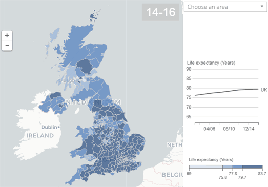
Why Are We Dying Younger?

Life expectancy in the UK and the USA is falling, bucking a century long trend of people living longer lives. The CDC says that between 2016 and 2017, the average life expectancy in the US fell from 78.7 to 78.6 years. In the UK this year the Institute and Faculty of Actuaries (which calculates life expectancy for the UK pension industry) cut the average life expectancy of people in the UK by a whole six months. That follows the two month cut in life expectancy it announced last year.

So why is life expectancy suddenly falling for the first time in over a hundred years?


Creating choropleth maps of average life expectancy can show us where people are living shorter lives on average. For example, the UK's Office for National Statistics has released information on the Health State Life Expectancies 2014 to 2016, which examines life expectancy in each area of the UK. This ONS report includes two interactive maps; one visualizing life expectancy in each local area in the UK and the other showing the gain in life expectancy in each local area since 2001-2003.

The map reveals that the best places to live if you want a long healthy life in the UK is Richmond upon Thames if you are male (69.9 years) and the Orkney Islands if you are female (73.0 years). The worst places to live are Dundee City for males (54.3 years) and Manchester for females (54.6 years). So why are men in Richmond upon Thames expected to live longer than men in Dundee and why are females in the Orkney Isles expected to live longer than women in Manchester?


The answer isn't just geography or climate. Time and again maps of life expectancy show us that life expectancy can vary by huge amounts even between neighborhoods which are very close together geographically. Quartz's Life Expectancy Map reveals the average life expectancy in nearly every US neighborhood. According to the map people who live in New York's Chinatown have a life expectancy of 93.6 years, while people who live in nearby Roosevelt Island have a life expectancy of just 59 years. Obviously it is not the climate in Chinatown that is helping its residents live longer than people on Roosevelt Island.

You can view the life expectancy at birth for each county in the USA on the University of Washington's US Health Map. A choropleth layer shows the life expectancy for every county in the country. FiveThirtyEight has used the same data (life expectancy at birth 1980-2014) to compare the life expectancy in each state to the U.S. average. Life Expectancy in Each State vs. U.S. Average reveals which U.S. states have higher or lower life expectancy than the country average. It also shows which states are improving or falling behind over this time period compared to the country average.

Again these maps show that there can be huge differences in life expectancy even between neighboring counties. To find out why people in some areas are now expected to live significantly shorter lives than people living in other areas we need to look at the underlying demographics of these areas. We need to explore some of the economic and demographic data which might begin to explain why some people are living longer than other people who live close by.


In the UK the University of East Anglia argues that health inequality is a major cause for the higher rates of premature mortality in some areas of the UK. The UEA's Year's Lost interactive map shows how many years of life are lost in each local authority area in the UK. The UEA's research shows that the rates of premature mortality are twice as high in the most deprived areas of England when compared to the rates in the most affluent areas.  In other words wealth (or lack of wealth) is a major factor in how long you can expect to live.

NBC News' map of How Long People in Your City Are Expected to Live reveals some of the underlying demographic and economic data which might begin to explain some of the huge differences in life expectancy between close neighbors. NBC's map colors each census tract by the average life expectancy. However if you click on a census tract on the map you can also view information on the median annual income, the percentage of the population without health insurance, the percentage without a high school diploma, the percentage of the population unemployed and the racial composition of the local population.

This extra economic and demographic data allows you to explore for yourself some of the possible causes of lower life expectancy. In fact NBC News have themselves provided a number of examples where census tracts in close proximity have vast differences in life expectancy. In Los Angeles they show how one tract in Palo Verdes has a life expectancy of 86.4 years, while a nearby tract in Long Beach has a life expectancy of 73.3 years. In the Palo Verdes census tract the average median income is $175.536, while in the Long Beach neighborhood the average income is $54,167.


Time and again the map reveals that areas with a high life expectancy are likely to have a high average income and areas with a lower life expectancy usually have a lower average income. In fact Associated Press' analysis of the National Center for Health Statistics' data on life expectancy found that on average life expectancy increased by six months with a $10,000 increase in median income. They also found a strong correlation between life expectancy and race. On average life expectancy decreased by eight months with a 10% increase in the black population.

What appears to be clear is that in both the USA and the UK average life expectancy is beginning to fall. None of these maps provide evidence that this falling life expectancy is a result of the middle-class squeeze in the USA and the UK. However it is apparent that those areas in both countries with the lowest life expectancy are on average the most deprived areas. In other words there is a high level of health inequality in both the USA and the UK.

Saturday, April 13, 2019

Leonardo da Vinci's Map of Imola


In the early Sixteenth Century NiccolĆ² Machiavelli and Leonardo da Vinci accompanied Cesare Borgia on his rampages through the Romagna region of northern Italy. Borgia, acting in the name of his father, Pope Alexander VI, was busy capturing city after city in order to create his own northern state in Italy. Machiavelli had been sent by Florence to accompany Borgia as an emissary-cum-spy. Leonardo was there because he had been employed by Borgia as a military architect and engineer.

While working in the role of military engineer Leonardo da Vinci created the 1502 Map of Imola. Borgia had captured the city of Imola at the end of the 15th century, which he then used as a base to attack Bologna, the main city in the region. Leonardo da Vinci was given the task of mapping Imola, possibly as a plan to strengthen the city's defenses. The map that he created is now renowned as one of the first scientifically accurate maps ever created.

If you want to explore the map in detail you can view an interactive zoomable version of Leonardo's Plan of Imola at the Royal Collection Trust. You can also view an interactive version of the map at Google Arts & Culture.

Leonardo's Plan of Imola is reported to be the oldest extant ichnographic or zenith map. An icnographic map shows every location depicted as it would be seen when looking directly down from above. The accuracy of the Leonardo map is a testament to da Vinci's scientific knowledge and probably to his own inventions of accurate scientific measuring tools, including the odometer and magnetic compass.


While surveying Imola Leonardo da Vinci may well have walked the city with his own design of odometer (measuring wheel). You can view one of da Vinci's odometer designs on Google Arts and Culture. This odometer consists of a wheel, used to measure the distance on the ground, and a tray of balls. The odometer holds a tray with a number of sections, each of which contains a ball or a stone. This tray is pushed along as the odometer moves. When each box passes over a hole the ball or stone it holds falls into a drawer. The number of balls dropped into the drawer gives the distance traveled.

As well as accurately measuring the lengths of roads, walls and buildings Leornardo da Vinci would also have had to measure the angles of the streets, building walls and city fortresses. To do this he could use his own design of magnetic compass. Henry Gillete in 'Leonardo da Vinci, Pathfinder of Science' describes this compass as "a board with an arc on it and a compass needle, and was probably the first magnetic needle on a horizontal axis."

The map itself contains a form of compass rose which frames the whole map. We are accustomed to seeing a compass rose placed in one of the corners of a map. The Plan of Imola doesn't have a small compass showing the cardinal directions. Instead the circular plan is marked itself with eight lines emanating from the center of the circle. The lines marking the cardinal directions are marked in da Vinci's own hand at the outer rim with the names of the main winds.

While in the city Machiavelli and da Vinci cooked up a plan (ultimately unsuccessful) to support the ambitions of Florence by stopping the Arno river from reaching Pisa, thus depriving the city of water. After leaving Imola, Machiavelli went on to write The Prince, of which the eponymous character appears, at least partly to be based on Cesare Borgia. Borgia himself wasn't able to enjoy his conquest of northern Italy for very long. After the death of his father, the Pope, in 1503, his fortunes quickly turned and he was killed in 1507.

Leonardo da Vinci went on to accomplish much more before his death in 1519. Not least among these achievements was his painting of the Mona Lisa. The mountains in the background of this painting are the Apennine mountains which da Vinci rode through while working as military engineer for Cesare Borgia.

If you want to see how revolutionary Leonardo da Vinci's map was then you can compare it with Hanns RĆ¼st's Mappa Mundi. This map of the world was created around 22 years before the Plan of Imola. Despite being created within a short period of time the maps belong to completely separate eras. Hanns RĆ¼st's map, inspired by a religious understanding of the world, is a product of the Middle-Ages while Leonrando da Vinci's Plan of Imola, created with scientific instruments, heralds the new Renaissance.