Understanding China's Belt & Road Project
China has spent more than 25 billion dollars on its Belt and Road Initiative (BRI). The initiative is designed to create the infrastructure to secure China’s trade routes and energy supplies. It is also being used to increase China's influence in the rest of the world. Kontinentalist has published a great introduction to China's Belt and Road Initiative in the form of an interactive story map.
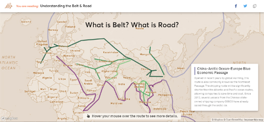
Understanding the Belt and Road both visualizes the physical infrastructure being built by China and explores the reasons why China is investing so much money in creating these transport links with the rest of the world. The interactive map first displays the six economic corridors that China are developing to connect the super power with Europe, Central Asia, Russia, and the Middle East. Each of these corridors can be selected on the map to learn more about each of the six individual routes. As you progress through the story the interactive map updates to explore the economic reasons behind the Belt and Road Project. To help visualize the economic reasoning behind the project the map is updated to show the population of China's major cities and regional GDP from 2012-2016.
Understanding the Belt and Road includes a number of other data visualizations which look more closely at how China is funding the initiative. In particular Understanding the Belt and Road examines the Asian Infrastructure Investment Bank, which China is developing to counteract the power of the Bretton Woods institutions of the World Bank, the International Monetary Fund, and the Asian Development Bank.
Understanding the Belt and Road also explores the diplomatic partnerships that China is developing with other countries. The interactive map is used to highlight on the map the '16+1 Initiative', China's partnership with 16 Central and Eastern European countries. It also shows how in Asia the 'Lancang-Mekong Cooperation', is building a partnership with all the Mekong countries. The map also explores the partnerships China is developing in the Middle-East and in Africa.
Finally Understanding the Belt and Road looks at some of the issues that China is facing in building such a huge initiative. These problems include territorial disputes where other countries might not be entirely supportive of China building economic corridors on disputed territory. It also explains some of the debt-trap diplomacy that China has used to impose its Belt and Road Initiative on countries which are heavily in debt to China.
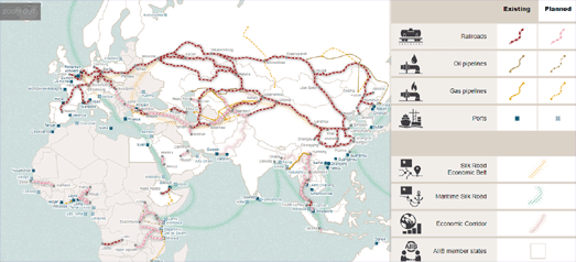
You can learn more about the BRI on the Mercator Institute for China Studies' Belt and Road Tracker, an interactive map which shows some of the many BRI projects spanning Asia, the Middle East, Europe and Africa. These projects include huge transport and oil & gas pipeline networks. The map sidebar allows you to show or hide different types of infrastructure project on the map. These include the railroads, ports and gas & oil pipelines which China has already constructed as part of its BRI. It also allows you to view railroads, ports and gas & oil pipelines which China plans to construct in the near future.
In One Belt, One Road the Financial Times also explores some of the construction projects being created by China to transport people and goods around the world. In The five main projects of the Belt and Road Initiative the South China Morning Post explores five huge Chinese infrastructure projects. These include a rail route from China to London, Gwadar Port, a rail route to Iran, the Asian gas pipeline and the Khorgas Gateway.


Comments