Friday, May 31, 2019

The Poetry of Places


Places of Poetry is a creative arts project which wants to inspire the English and Welsh to write poetry about the places that inspire them. The project hopes that budding poets will pin their poems about English and Welsh locations directly to the Places of Poetry interactive map.

Users can add poems to the map from now until the 4th October 2019. After that date new poems will not be able to be added. The map, however, will still be available for those who wish to read all the poems added during the project. Poems can be submitted in English and Welsh. All poems will be reviewed before being added to the map in order to ensure that no offensive or plagiarized work is published.


As a cartographer what most attracts me about the Places of Poetry project isn't so much the poetry but the map itself. The background map used for Places of Poetry is inspired by William Hole's engraved maps created for Michael Drayton epic poem Poly-Olbion (1612). The Places of Poetry map is an original work but is heavily inspired by Hole's highly decorative and iconographic style.

The Place of Poetry map includes new icons celebrating some of the UK's most well known heritage sites. These include Stonehenge, Ely Cathedral and even the Oval cricket ground. Other icons on the map (for example for forests and farming regions) are more direct copies of Hole's iconography. The marine icons of Neptune, sirens and ships are also direct copies from William Hole's engraved maps.


Fans of poetry may also be inspired by the Poetry Atlas, an interactive map of poems written about locations around the globe.

Thursday, May 30, 2019

Mapping 2000 Unmarked Graves


Between 2006 and 2016 nearly 2,000 clandestine graves were found in Mexico. The graves contained 2,884 corpses, 324 skulls and thousands of fragments of bones belonging to an undetermined number of individuals. The graves were dug by criminal gangs. The bodies were the victims of gang violence.

In The Country of 2000 Graves A donde van los desaparecidos has mapped out the locations of all 2000 clandestine graves. To collect the data for the map A donde van los desaparecidos submitted freedom of information requests to all Mexico's state attorney's offices. The interactive map includes a timeline which allows you to explore the data by year. This timeline includes two animation options to either view how many graves were discovered each year or view the accumulated total of graves discovered over time since 2006.

Not all of the state attorney's offices responded to the request for data so it is highly likely that there are more clandestine graves which have been discovered and that are not shown on the map. The article accompanying the interactive map includes an analysis of which states have discovered the most clandestine graves and bodies. The article also includes links to view individual interactive maps for each state. These individual state maps include charts showing the number of graves and corpses discovered in each state by year.

Famous People of the USA


The Pudding has created a really interesting map which shows the most famous person from each town in America. A People Map of the USA renames every town in the country for its most Wikipedia'ed resident. So on this map Dodge City becomes 'Wyatt Earp Dodge City' and Memphis becomes 'Elvis Presley Memphis'.

I've seen a number of comments online questioning some of the strange results on the map. For example, 'Kublai Khan' for Sherman, Texas. This is a result of using the Wikipedia API to retrieve the names of people on the thousands of "People from X city" pages on Wikipedia. The People from Sherman list for the Texan town includes the band Kublai Khan. Of all the people listed under the Sherman entry Kublai Khan are the most looked up on Wikipedia.

If you want to see whose Wikipedia page has the most page views you can do this yourself by using Pageviews Analysis. Just enter names into Pageviews Analysis and you can view how much traffic their entries on Wikipedia receive.

On The Pudding's map the biggest name labels indicate the most Wikipedia'ed individuals. So the label for Elvis Presley (Memphis) is much bigger than the label for Stevie Nicks (El Paso) because his page on Wikipedia is viewed far more often than hers. On a casual view of the map it does appear that singers and actors are among the most viewed pages of people listed on Wikipedia. For example George Washington isn't even the most notable person associated with the U.S. capital. According to The Pudding's map Washington D.C. should be renamed Samuel L. Jackson D.C..

Where Europeans Move in Europe


In the 2019 European Elections far-right nationalist political parties won the largest share of the votes in the UK, Italy and France. These extreme right-wing parties all share a dislike for the European Union and immigration. They all wish to stop the freedom of movement for workers in Europe. Which raises the question of whether internal immigration in Europe is a huge problem in these countries.

How Europe Moves is an interactive map visualizing the number of European citizens of working age living in another European country (2017). The map uses scaled circles and flow lines to show the number of internal (to Europe) immigrants and emigrants in every European country. Of the three countries voting for extreme right-wing parties only the UK has a significant net gain in workers moving between European countries (2,730,000 workers in and 454,000 workers out). France has a slight net gain (875,000 in, 572,000 out). Italy actually has a net loss 1,160,000 in and 1,300,000 out).

Germany and the UK are the countries with the largest numbers of European internal migrants. However in terms of the percentage of the working age population Luxembourg (45%), Switzerland (19%), Ireland (12%) and Cyprus (11%) have the most internal European migrants. Eastern European countries and Portugal are among the countries with the biggest percentage of the working age population emigrating to other European countries.

The flow lines on the How Europe Moves map reflect the numbers of people moving between different countries. If you click on a country the map will switch to just show the migration flow for that country. This makes it easier to determine where migrants are coming from and going between individual countries. For example, the UK is the most popular destination for Polish emigrants. Italy is the most popular destination for Romanians. France is the most popular destination for the Portuguese. Germany is the most popular destination for Italians.


In Europe citizens within both the EU and the European Free Trade Association (EFTA) are free to live, study, work and retire in any other EU or EFTA country. Swissinfo has undertaken a more detailed look at internal migration in Europe and created a map which shows which individual regions of Europe have a net gain or loss of workers.

Which European countries attract the most immigrants? shows the difference between the number of immigrants and emigrants in each region based on movement within the free movement area. Areas with a positive net migration rate (where more people are moving to) are colored blue on the map and areas & regions with a negative net migration rate (where people are leaving) are colored brown on the map.

As you might expect migrants within Europe tend to move to regions that have the strongest economies. Conversely the areas and regions where the most people move from tend to be areas with weaker economies. This map is featured in Swissinfo's 'migration' series. This in-depth series explores the issues of migration around the world (particularly in how it effects Switzerland) and includes a number of maps and other data visualizations of global and European migration data.


If you want a list showing the number of immigrants and emigrants in individual European countries and where they came from and where they went then you can check out the Pew Research Center's the Origins and Destinations of European Union Migrants within the EU.

This interactive map allows you to select individual European countries and view choropleth maps showing internal and external migration between the selected country and other European countries. It also lists the numbers moving to and from the chosen country and the other countries of Europe.

Wednesday, May 29, 2019

Global Homicide Rates


El Salvador has the highest homicide rate in the world. The good news for El Salvador is that its homicide rate has actually dropped for three years in succession. In fact the homicide rate in El Salvador has fallen by half since 2015. Unfortunately the current rate of 56.69 homicide per 100,000 people (2017) is still way higher than the rates in most other countries in the world.

You can view an interactive map visualizing the homicide rates in countries around the globe on Our World in Data. Their Homicide Rate map colors individual countries by the number of homicides per 100,000 people in each country. If you want to view the trend over time then just click on a country on the map. You can then view a graph which shows the homicide rate in the selected country by year.


The Homicide Monitor also visualizes homicide rates across the world, only this time on an interactive 3d globe. When you first load the Homicide Monitor the globe animates through the ten countries with the highest homicide rates.

If you pause the animation you can explore the data yourself by selecting individual countries on the map. Click on a country and you can view the country's homicide rate, a graph of the homicide rate over this century, the percentage of those killed by firearms and the percentage of people killed by gender. You can also view where the Homicide Monitor sourced its homicide data for the selected country.

Our World in Data and the Homicide Monitor use different data sources for their homicide rates. The two maps therefore don't always agree on individual country homicide rates or the countries with the largest and smallest homicide rates.

Here be Pirates!


If you want to avoid pirates while sailing the seven seas then you should steer clear of the equator. Around the globe pirates seem to be most active off the coasts of countries that are close to the equator. You can view this for yourself on John Nelson's 40 Years of Nautical Piracy interactive map.

40 Years of Nautical Piracy is a heat map which visualizes where pirates have been most active around the world over the last 40 years. The map uses data from the National Geospatial-Intelligence Agency to show the most dangerous maritime locations in terms of marine piracy.

The map uses equal area hexagons to show the frequency of incidents across the globe. You can click on an individual hexagon on the map to see how many individual incidents there have been in that area. If you zoom in on the map then the individual incidents will be shown as single dots on the map. If you select an individual dot then you can read a description of the piracy event. Once you start reading these descriptions you soon realize how seriously dangerous piracy can be to sea vessels.

You can read more about the map and view a video on how the map was made on the Esri Blog's 40 Years of Piracy post.

The Great Pacific Garbage Patch


The Center for Biological Diversity has created a simple but very effective mapped visualization of the Great Pacific Garbage Patch. The visualization allows users to drag a polygon shape, representing the physical size of the gyre, over any location on Earth. In this way it is possible to directly compare the size of the garbage patch with familiar locations.

The drag & drop map in Ocean Plastics Pollution may not be entirely scientifically accurate but it is a very powerful visualization tool. Much of this power comes from its simplicity. It is just a huge shape on a map which you can drag around to more clearly understand its vast size. The map was also ridiculously easy to make.

The Google Maps API has a simple function for creating draggable polygons. It also allows you to make the polygons geodesic so that the shape changes size as you drag it north or south. If you want to make a polygon draggable in Google Maps you simply have to set draggable and geodesic to true in the polygon's properties:
draggable: true,
geodesic: true
It really is as simple as that.


Another map which makes great use of draggable polygons is The True Size Of. The True Size Of allows users to compare the size of different countries by dragging any country on top of any other country. Why not see how many countries you can fit inside Russia.

Tuesday, May 28, 2019

The US Bombing of Raqqa


Six children aged between 15 months and 13 years were killed on 5 September 2017, when a Coalition air strike hit their home in the town of Raqqa in Syria. The children were just six of the hundreds of civilians killed by the US-led Coalition's military campaign to oust Islamic State in Raqqa. Amnesty International has carried out extensive investigations on the ground in Raqqa and carried out crowdsourced remote analysis to reveal the cost of the Coalition's military campaign. War in Raqqa allows you to explore the results of this investigation into the civilian deaths in Raqqa, which were the result of the Coalition airstrikes on the city fired between June and October 2017.

Amnesty International's analysis includes an interactive map showing the locations in Raqqa of civilian casualties from Coalition strikes. On the map black circles are used to show verified casualties and the grey markers reveal the locations of casualties with 'credible reports'. If you select a marker on the map you can view details of the selected airstrike and its resulting casualties. These details include photos of the victims (where available) and before & after satellite imagery of the location hit by the coalition airstrike.

In order to determine when and where buildings were destroyed in Raqqa Amnesty International crowdsourced the analysis of satellite imagery of the city. Volunteers were asked to examine a timeline of satellite images to pinpoint the dates of a building's destruction. You can read more about this crowdsourced investigation on the project's Strike Tracker website.

SOS Air Pollution


Greenpeace has released an interactive map showing air pollution in Russia. SOS Air shows air pollution data from road traffic, landfill and industrial sources. It also shows the latest air pollution readings from monitors across the country and the air pollution generated by traffic on the country's roads.

The SOS Air interactive map shows the location of stationary sources of air pollution such as industrial plants, landfill sites, incinerators and other industrial facilities. This information is based on data from OpenStreetMap. Volunteers from across Russia are helping to gather information about these individual stationary sources of air pollution and the map will be updated to show what is exactly emitted by each location and the levels of air pollution produced.

The biggest source of air pollution in large towns and cities is road traffic. SOS Air shows near real-time air pollution on city roads based on local traffic conditions. The more congestion there is on the roads then the more air pollution is generated. The air pollution data from near real-time road congestion comes from Mapbox's traffic service.

The colored markers on the map show the latest readings from air pollution monitors across the country. If these monitors show dangerous levels of air pollution SOS Air users can submit air pollution complaints directly from the map. Greenpeace will then pass these complaints on to the relevant government authorities.

Monday, May 27, 2019

Hotter or Not?


The world's four warmest years were 2015, 2016, 2017 and 2018. If that doesn't convince you about the truth of global heating then you can always refer to Axios' Climate Change Globes.

These two side-by-side interactive globes visualize the annual average surface temperature change across the world before and after 1970. Because the globes are interactive you can spin them around to see the extent of climate heating everywhere in the world. The article accompanying the interactive globes reveals that 2019 already looks like being another record year for global temperatures. In other news the Arctic sea ice extent in April was a record low and carbon dioxide levels have passed 415 parts per million for the first time in human history.


Buzzfeed has created two interactive maps which show how the climate emergency is affecting temperatures in countries across the globe. How Climate Change Has Already Transformed The Earth features two maps. One shows how temperatures have risen over the last 138 years. The other reveals how sea levels have risen since 1993.

The first interactive map visualizes the rate of global warming around the world since 1880. Click anywhere on the map and you can view a graph showing the changes to the average temperature at that location for the last 138 years. As well as creating a graph of temperatures over time the map includes a choropleth layer which reveals where temperatures have risen since 1950. This layer provides a stark illustration of how global warming has affected locations around the world, in particular in the Arctic. If you click on individual years on the interactive temperature graph you can see by how many degrees the temperature has risen at the selected location.


If you want to know how hot your hometown will become if climate heating continues then you can find out using a clever interactive map from 23 Degrees. Enter your location into the tool and you can find your climate analog for the year 2080. For example in 2080 London will experience weather which resembles the climate in Lima today. Frankfurt in Germany will be as hot as Malawi and living in Berlin will be like living in Lesotho in southern Africa.

You can find your 2080 climate twin using The Summer of 2080 Will Be This Warm interactive map. If you enter your location or click on your location on the map you can view the town or city in the world which has a climate now which is similar to the climate you can expect in your location in the year 2080. The map uses two different climate models. This allows you to find your climate twin for a global heating scenario of 4.2 degrees or 1.8 degrees.

When you search for your climate twin the map displays some details of the kind of weather experienced by your twin now (and which you can expect to experience in the year 2080). This includes the annual rainfall and the number of extreme hot and cold days.

2019 European Election Maps

The big two political groups who have historically dominated the European Parliament have failed to win overall control in the 2019 European Elections. Neither the centre-right European People's Party nor the Socialists and Democrats bloc achieved enough seats to form a working majority.

The general trend across Europe seems to have been for a fall in votes for the centre-right and centre-left parties. Far-right and nationalist parties have performed well in many countries across Europe. The Green Party has also seen a large rise in its share of the vote across much of the continent.

National newspapers and news channels in Europe tend to concentrate on national news. The first mapped visualizations of the 2019 European Elections are mostly limited in scope to individual countries. Here is a round-up of some of the election maps created for individual countries across the continent:

Germany

Zeit has released a choropleth election map colored to show the level of support for the winning party in each electoral district. It has also created a series of small multiples showing the level of support across Germany for each of the political parties. These small maps show that there is still a large political split between the former East Germany and West Germany.

The three largest parties the Christian Democratic Union, the Greens and the Social Democratic Party were most popular generally in electoral districts in the old West Germany. Angela Merkle's CDU remained the largest party in Germany, although its share of the vote dropped from 35% (2014) to 29%. The SPD also experienced a large drop in support, from 27% to 15.5%. The Greens made the biggest gains winning 21 seats and 21.5% of the votes (up from 10.7%).
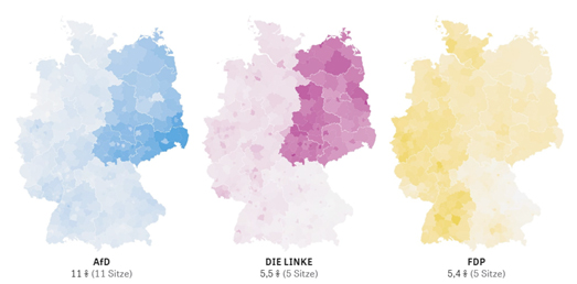

Support for the extreme left party, Die Linke and the extreme right party, AfD was strongest in electoral districts in the old East Germany. The extreme right-wing party AfD did improve their share of the vote from 7.1% in 2014 to 11% but didn't make the huge gains that far right and nationalist parties made in some other countries in Europe.

United Kingdom

The BBC has mapped out the 2019 European election results in the UK. The BBC's map is colored to show the party which won the largest share of the vote in each electoral district. However the map also allows you to view a choropleth view of support across the country for each of the major political parties.

In England and Wales the nationalist Brexit party was the big winner with 33% of the vote. However they only achieved 19.9% of the vote in Scotland, where the Remain supporting Scottish National Party won 28.4% of the vote (up 7.7% since 2014). The biggest news in the UK (aside from the large share gained by Brexit) was the complete annihilation of the governing Conservative Party who only managed to win 8.8% of the national vote. The Labour Party also saw a 10.8% drop in its share of the vote, down to 14.6%.

France

In France Le Monde has mapped out the winning political party in each electoral district. The far-right National Rally party of Marine Le Pen narrowly beat President Emmanuel Macron's La République en Marche party. There was less than one percent between the two parties and they will both have the same number of seats in the European parliament (23 seats each).

The traditional left-wing and right-wing parties in France each failed to achieve 10% of the vote. The Greens were the third largest party, picking up 13.5% of the vote and 13 seats. Although the far right National Party won the largest percentage of the vote (just) their share of the vote in 2019 is actually down by about 1.5% on 2014.

Spain

The traditional left-wing parties of Europe have seen a loss of votes in most of the continent. But not in Spain. The Socialist Party (PSOE) won the largest share of the European Election votes in Spain with 33%. The right-wing Popular Party (PP) were the largest party in 2014. The collapse of the SPD in Germany means that the PSOE could be the largest party in the Socialists and Democrats bloc in the European Parliament.

The far-right Vox party won only 6% of the vote in Spain and will have three seats in the European Parliament.

Belgium

De Morgen has mapped out the European Election votes in Belgium. The New Flemish Alliance (N-VA) were the big losers in these elections, dropping their share of the vote by 14.2% since 2014. The far right-wing Vlaams Belang increased their vote share by 12.1% and the Greens increased their share of the vote by 7.8%. The N-VA and Vlaams Belang will now have three seats each in the European Parliament and the Greens will have one seat.

The political map of Belgium always shows a large geographical split between Wallonia (French speaking) and Flanders (Flemish speaking). This is essentially a result of the electoral system which says that voters can only vote on the lists depending on the language area they live in. The country also has different political parties standing in each of the two main regions (both N-VA and Vlaams Belang are Flemish parties who advocate for the secession of Flanders from Belgium).


Note: counting of votes is still continuing across Europe and results are accurate at time of writing.

Sunday, May 26, 2019

A Border of Trees


This Google Earth Engine satellite view from 1984 shows the border between Belize and Guatemala. The actual border between the two countries is impossible to see in this satellite image because it is obscured by the rain-forest. However if we fast-forward to 2018 it is very easy to see the border - because Guatemala has chopped down all of its trees.


You can use Google Earth Engine to explore this deforestation in Guatemala for yourself. You can even animate the timeline to view the disappearance of the rain-forest in the country over the last thirty odd years. Guatemala, according to Global Forest Watch, has lost nearly 17% of its forests since the start of this century.

The reason why Belize still has such a large rain-forest and extensive biodiversity is that the government has protected the environment. According to the World Database on Protected Areas 37% of the country has some kind of official protection. In Guatemala, on the other hand, the government has allowed oil companies to decimate the Laguna del Tigre National Park. Elsewhere the government has allowed forests to be stripped for sugar cane, palm oil and other agriculture. There has also been extensive deforestation for cattle farming.


Here is another view of the border between Guatemala and Belize from Global Forest Watch. The green color is used to show tree cover on the map. The pinky-red color shows where there has been tree-cover loss since 2010. Can you guess where the border is?

Saturday, May 25, 2019

Indian Election Maps


The Bharatiya Janata Party (BJP) had a landslide victory in the Indian election and increased its already huge parliamentary majority. The BJP, led by the current Prime Minister Narendra Modi, won 303 seats in the Lok Sabha, the lower house of India's parliament. The next largest party, the Indian National Congress (INC), only managed to win 52 seats.

The Indian Express has released an interactive map of the Lok Sabha Election Results 2019. The map shows the winning party in each of the 543 constituencies. The map includes a cartogram view of the results which shows each of the constituencies as an equal sized square. Despite the BJP's huge majority there is still a geographical divide in support for India's political parties. The BJP won lots of seats in the north-west and center of the country. It won far fewer seats in the south and along the eastern seaboard.

The 2019 Lok Sabha election was the first election in India where women voted in equal numbers to men. The number of women who won a seat in the Lok Sabha was also the highest ever. The Indian Express map includes a filter control which allows you to see where female candidates won in this election. Although the number of female held seats has increased since the last election women still hold less than 10% of the seats in the Lok Sabha.


The Financial Times has created a choropleth map of the election results, which gives you an overview of the level of the winning majority in each seat. Again this view shows a north-south divide in the support for the BJP. Some of the party's biggest majorities were in the northern states of Himachal Pradesh and Uttarakhand.

Reuters' India Election Results interactive map also provides a 'margins' view, showing the margin of victory for the winning candidate in each seat. You can hover over individual seats on the Reuters map to view the percentage of the votes won by each of the main candidates. The Reuters map also includes a choropleth view of the voter turnout in each seat.

Friday, May 24, 2019

Send a Selfie Around the World


You can now send a selfie to yourself using Google's 'Network Journey'. Upload a picture to Google's latest Chrome Experiment and Google will send it around the world and then send it back to you, covered with the internet visa stamps it has gathered on its journey.

Network Journey is actually a clever demonstration of the speed of the Google Cloud network. After you post your picture to Network Journey you can watch it travel around the globe on a map of the world. As your photo passes through each Google Cloud data center it is given a country stamp. After your selfie has completed its global journey you will also be told how many seconds it took to circumnavigate the globe.

If you want to explore how your selfie traveled across the globe in a little more detail then you might like the Infrapedia - Global Internet Network, Datacenter and Infrastructure Atlas. This interactive map shows the location of the data centers, undersea cables, IXPs and networks which make up the global internet.

How Europe Votes


From now until Sunday people in the European Union will be voting to elect their Member of the European Parliament. Some countries, such as the Netherlands and the UK, voted yesterday. Many other countries will not hold elections until Sunday. In order to avoid early results affecting how people vote elsewhere in Europe no results are allowed to be published anywhere in Europe until Sunday night.

If you can't wait until Sunday night for the results of the 2019 European Union Election then you can explore Zeit's Europe from Left to Right interactive map. This map colors 80,000 regions in Europe based on the most recent election results in that country. The map is therefore not a map of how people have voted or intend to vote in the 2019 EU election instead it maps out which way people voted in their most recent national election.


On the map you can select any of the main political groups to see how they have most recently performed across Europe. For example if you click on Green you can view a choropleth map of how much support there is across the continent for Europe's Green parties (Lithuania and the far north of Finland seem to show the most support for Green parties). If you click on the extreme right you can see that in the most recent national elections Poland, Austria and northern Italy have all shown a high level of support for extreme right-wing political parties.

The colors assigned to each country's political parties is determined by the the Chapel Hill Expert Survey, which categorizes political parties in European countries based on their positions on ideology, European integration, and policy issues.

Thursday, May 23, 2019

The Air Space Mafias


When you buy a ticket for an international flight the price will partly be determined by airspace fees, the charges that countries around the world require airlines to pay for flying in their airspace. For example an airline flying from Japan to New Zealand has to pay the USA a fee even though the flight goes nowhere near the USA. This is because the USA claims the airspace over a massive portion of the Pacific Ocean.

As well as using airspace as a form of generating revenue countries also use access to their airspace as a political tool. So flights to Israel historically have not been allowed to fly over Arab countries and Taiwanese flights cannot travel over mainland China. Recently Pakistan has restricted access to its airspace after an Indian airstrike was made on Pakistani territory.

The South China Post in Why the World's Flight Paths are Such a Mess has taken a closer look at the historical, political and financial reasons for why planes take the routes that they do. The story includes numerous maps of some of the strange flight paths that airlines have to take to get from A to B and a host of interesting facts about how flight restrictions and airspace fees can determine those routes.

Many flight routes have been improved in recent years because Russia and China have become a bit less restrictive in controlling the air space over their countries than during the height of the Cold War. However both China and Russia still have more restrictions than most western countries. The South China Post says that China will replace the US as the biggest flight market in the world by 2036. At the moment the army controls 80% of Chinese airspace. In order to manage the future growth in air travel the country will need to be a lot less restrictive over how its airspace is used.

How Your Neighbors Voted


Jackson, Mississippi is the most politically segregated city in America. In Jackson Democrats and Republicans tend to live in very different areas of the city and there are very few neighborhoods where both Republicans and Democrats live side-by-side.

FiveThirtyEight has released a new tool which allows you to see Where Democrats and Republicans Live in Your City. If you enter an address into the tool you can view an interactive map colored to reveal where your city voted Democrat and Republican. On the interactive map each precinct is colored to show the margin of support for the most popular party based on the 2016 Presidential election.

After viewing the map of your city you can scroll down the page to see how segregated your city is based on FiveThirtyEight's partisan dissimilarity index. This ranks your city based on how politically divided it is. Having looked at the results across the USA FiveThirtyEight claim that Republican enclaves in cities tend to be in low-density, less centralized neighborhoods. The cities with the highest political segregation tend to be cities with a high proportion of black residents. Looking at FiveThirtyEight's list of the cities with the highest partisan dissimilarity index score it appears that the most segregated cities are in the Deep South. As FiveThirtyEight points out the "persistence of racial segregation in American cities continues to define those cities’ politics".

What Happened to the Romanovs?


The Russian Imperial Romanov family ruled over Russia for over 300 years. That rule came to an end with the Russian Revolution. In 1917, during the revolution, seventeen members of the imperial family lost their lives. 45 other members of the extended Romanov family managed to escape Russia and fled to other parts of the world.

The Russian news agency Tass has created a data visualization project which traces the history of every single member of the Romanov family from 1847 to 2007. The project consists of a family tree, an interactive map and a timeline. The interactive map in The Romanov's Twilight shows where individual members of the Romanov family ended up after the revolution. 13 of the family, including Emperor Nicholas II and his immediate family, were killed in the city of Yekaterinburg. Some members of the Romanov family managed to escape the revolution and ended up living in countries around the world, including the USA, the UK, Argentina and Egypt.


If you click on an individual Romanov in the extended family tree you can view a brief biography of the chosen individual. This biography also includes an interactive map. This small map shows the individual life journey of the selected Romanov. The map shows their place of birth, where they died and other places where they may have lived in between.

If you are interested in Russian history then you might also like Borders of Russia 1462-2018, which is an interactive map visualizing the ever changing political boundaries of Russia since the 15th Century. You may also be interested in Histography's interactive map of Russian History. This map explores Russia's history from the year 862 right up until the present day.

Wednesday, May 22, 2019

Where the Richest Australians Live


Australia's richest people seem to live in New South Wales and Western Australia. All 10 of the top neighborhoods for income earners can be found in these two states. Ashburton in WA has the highest proportion of residents who are in the top income bracket in the whole of Australia. According to ABC this is due to the 'prevalence of the mining industry in the area'.

ABC has mapped out the average annual income in each local government area (LGA) in the country. ABC's How does your income compare to everyone else’s? includes a story map which takes you on a tour of a choropleth visualization of the average income in each LGA. This story map highlights the areas of Australia with the highest and lowest average incomes. The areas with the lowest average incomes can often be found in regions with a higher than average Indigenous population. These areas also tend to be very remote.

As well as this interactive map the ABC article includes a tool which can tell you where you sit on the scale of the lowest to highest-earning Australians, based on your income. Enter your weekly income into this tool and you can find out the percentage of the country who earn more than you and the percentage who earn less. The article also includes information on which professions make up the largest proportion of those in the top income bracket.

The Global Internet Map


This blog post was written on my laptop in London. From there it was sent digitally along fiber optic cables from my home to my Internet Service Provider's port servers. From there the post traveled to Google's servers and from there it travels via the global internet network to computers around the world. To reach your computer or phone this blog post has traveled along thousands of miles of terrestrial and submarine cables.

The Infrapedia - Global Internet Network, Datacenter and Infrastructure Atlas is an interactive map of the data centers, undersea cables, premium vendors, IXPs and networks which make up the global internet. The map is fully interactive, which means you can select individual cables and data centers on the map to discover information about who they are owned by and when they were built.Where available this information also includes a link to the service's Wikipedia page.

If you select the 'Future Only' option you can view cables which are currently under construction or which are in the planning stages. Selecting these cables on the map allows you to learn which year they will become active.


Every year Telegeography releases a new updated version of its interactive map of the global network of undersea telecommunication cables. The 2019 Telegeography Submarine Cable Map highlights the huge recent building boom in submarine cables. In the next few years around 107 new submarine cables will be laid around the world, adding over 400,000 kilometers of new telecommunication cable to the global network.

A number of information insets along the bottom of Telegeography's 2019 internet map help explain this new building boom. These include insets showing new countries which will soon be connected for the first time and the amount of new cables being laid in the different global regions. Content providers, such as Google, Amazon, Facebook and Microsoft, are investing and driving much of this new building boom in submarine cables. An inset for each of these companies shows where each company is driving the construction in new submarine cable infrastructure.

Rivers Should Flow Free


The number of free-flowing rivers around the world is falling drastically. Of the world's longest rivers (over 1,000 kilometres in length) only a third remain free-flowing. These remaining free-flowing rivers can only be found in areas which are relatively underpopulated by humans, for example in the Arctic and the Amazon and Congo basins.

The result of restricting the free-flow of rivers is extensive damage to the environment, river biodiversity and floodplain agriculture. The free-flow of rivers can be disrupted in many ways, including dams & reservoirs, the construction of buildings & bridges, agriculture and disruption to natural aquifers and floodplains. Free-flowing rivers contribute to biodiversity, they help to maintain natural floodplains, they help to maintain fish stocks and contribute enormously to the recreation and tourism industries. Where possible rivers should be allowed to flow free.

The World Wildlife Fund is creating a global database to map the world's remaining free-flowing rivers. They have also released the Free Flowing Rivers interactive map to visualize the worlds remaining free-flowing rivers and to allow you to explore in what way the free-flow of rivers is being disrupted. The 'Story Mode' section of the map takes a closer look at the drastic impact of human construction on natural river environments around the globe. It also explores how removing outdated human infrastructure can help to restore the natural flow of rivers.

What's Next For Google Maps?

If you've been wondering where the Google Maps API is heading then you might have already watched the live streams from the Google I/O conference last week. Traditionally the Google Maps team have used I/O to announce any big changes or developments to its interactive mapping platforms.

If you didn't view the live streams then you can catch up on the latest developments on the Google Maps blog post What’s next for Google Maps Platform. From an outsider's perspective the two main announcements made at I/O this year (as far as maps are concerned) are Deck.GL's support for Google Maps and the beta release of the new Maps SDK for Android.


Deck.GL

Google Maps has partnered with Deck.GL so that Deck.GL can now be used with the Google Maps API. Deck.GL is an opensource data visualization library which uses WebGL technology to enable the visualization of very large datasets on interactive maps. For example this Paris Trees map, created with Google Maps and Deck.GL shows the location and genus of 203K trees in the French capital.

To get started using Deck.GL with Google Maps you should check-out the Deck.GL / Google Maps documentation.

Maps SDK for Android

Google also announced the beta release of the next version of the Maps SDK for Android. The big change in the new Maps SDK for Android is that it is built on entirely the same infrastructure as the Google Maps mobile app. This should lead to improvements in performance and lead to a large decrease in data consumption.

Tuesday, May 21, 2019

Storm Chasers Live


Live Storm Chasing is an interactive map which allows you to follow a number of storm chasers as they track storms across the USA. The map also provides information about the latest weather warnings and storm reports from across the country. Most importantly you can watch the live broadcasts of storm chasers directly from the Live Storm Chasing map.

The current positions of the storm chasers are shown on the map using colored dots. The storm chaser locations are updated every minute on the map. You can see which storm chasers are currently broadcasting in the map sidebar, where active broadcasters are indicated with a red 'live' indicator. You can watch any of these live broadcasts by clicking the eye icon in the map sidebar or by selecting a storm chaser on the map.

The map sidebar also allows you to filter the weather information shown on the map. These weather layers include a number of different options for viewing the current weather conditions across the United States. A radar layer provides up-to-date precipitation information. Local storm reports provide updates on local storms around the country. You can also view the latest hail, snow, flooding and tornado reports.

Mapping Europe's Wolf Populations


The wolf population in Switzerland is growing. In 2010 there were only five wolves in the whole of Switzerland. Last year a total of 47 individual wolves were counted. Switzerland's wolf population is also moving more widely throughout the country. At the beginning of this decade the wolves, which entered Switzerland from Germany, were found only in the west of the country. They are now more evenly distributed across the whole country.

Swiss newspaper Neue Zurcher Zeitung has been mapping out the spread of wolves in Switzerland. In Wolf in Switzerland the newspaper has published an interactive map which shows where wolves have been spotted during the last year. The newspaper has also created a map which shows the movement of one of the wolves over the course of just two months. In January and February the wolf M75 walked across the whole width of Switzerland from south to north.


Switzerland's wolves entered the country from Germany. The wolves in Germany in turn originally came from Poland. Back in the year 2000 the first wolf in modern times arrived in Germany, crossing from Poland into the eastern state of Saxony. There are now reported to be over 1000 wolves in Germany. The Berliner Morgenpost has created an interactive map which animates how these wolves have repopulated the country.

If you press 'play' on the interactive map in Wölfe in Deutschland you can watch how wolves have spread, mostly across the north of the country, since the turn of the century. The map includes colored markers to indicate single wolves, pairs of wolves and wolf packs. The map also includes a search function which allows you to view how close the nearest wolves have been spotted to your home.

The wolf is not only on the rise in Germany. All countries in mainland Europe now have wild wolf populations. The Guardian has published a static map showing the wolf populations in different European countries. The Selected European Wild Wolf Populations map shows that the southern countries of Spain, Italy and Romania currently have the largest wolf populations in Europe.

Hate Crimes in India


India’s National Crime Records Bureau does not record hate crimes separately from other crimes. It is therefore unable to document or spot the rise of religious based hate crimes in India. Which is why the Hate Crime Watch project was started in 2018. Hate Crime Watch is tracking crimes which have been committed against people or groups in India because of their caste, religion or ethnicity. Although the project was only launched in 2018 it includes data on religious motivated hate crimes carried out in India since 2009.

The Hate Crime Watch interactive map plots individual hate crimes to the location where they were carried out. The map includes a number of filter controls which allow you to filter the hate crimes shown on the map by year, type of assault and by individual state. If you select an individual dot on the map you can read details on the selected hate crime and view the source where Hate Crime Watch learned of the crime.


As has already been mentioned India’s National Crime Records Bureau does not record incidents of hate crime as actual hate crimes. Which is why Amnesty International has also released an interactive map that tracks incidents of hate crimes across the country. Halt the Hate maps crimes which have been committed against people or groups in India because of their caste, religion or ethnicity.

The Halt the Hate map is a very basic interactive map. You can't zoom in on the Amnesty International map and because the map has no place-labels it is very difficult to search this map by location. However the map does include a number of filter controls which allow you to explore the data by year, motive and individual states. Each hate crime incident shown on the map is based on media reports.

Monday, May 20, 2019

The Problem with Australia's Election Maps


The 2019 Australian Election has been a bit of a disappointment for those interested in election maps. Generally the maps visualizing this year's election have been unimaginative and on the whole deceptively misleading.

There is a glaring problem with mapping Australia's election results, which comes from the huge variations in size between different electoral divisions. For example, Durack, in the north-west of the country is 1,629,858 square kilometers in size and bigger than many countries in the world. While, at the other end of the scale, the electoral district of Grayndler is just 32 square kilometers in size.

Here lies the major problem. Both Durack and Grayndler have one member in the House of Representatives. Yet Durack appears nearly 51,000 times larger on the map than Grayndler. Durack was won by the Liberal Party in the 2019 election. Grayndler voted for the Labor Party. On all the election maps I've seen of the Australian election the blue colored Durack has a huge visual impact, while the red of Grayndler is almost impossible to see - despite both electoral divisions having the same number of members in the House of Representatives. This is a visualization nightmare.

I challenge you to find Grayndler on The Age's How America Voted interactive map (the same map also appears in the Sydney Morning Herald). Grayndler is so small that it is almost impossible to find on the map. One purpose of using a map to present election results is that people can quickly find different electoral divisions to view the local results. If you need to use the search facility to find Granyndler then I would argue that the map is lacking as a search tool and that the data would be better presented in a table or chart.

There might have been some purpose to The Age's election map if it provided some kind of visual guide to the results. However reading the map based purely on the proportion of the different colors suggests that the Liberal Party won around 75% of the votes and the Labor Party won around 20%. In fact the Labor Party (so far) has won 65 seats and the Liberal Party has won 42.

This problem of visualizing election votes is not unique to Australia. Many countries around the world, including the USA and the UK, have similar patterns of voting - where right-wing parties often win the large (in geographical size) seats while the left-wing parties win the smaller urban and suburban seats. The problem is just exasperated in Australia because of the really huge differences between the largest and smallest electoral divisions.

Any election map of Australia, which sticks to any kind of geographical accuracy, is going to visually under-represent the Labor vote while over-representing the Liberal vote. The Guardian's Australian Election 2019 interactive map manages to cope with this problem better than The Age's map. The Guardian's map still gives far too much visual weight to the Liberal Party but it has more clearly defined the boundaries of the electoral divisions. While the color blue still clearly dominates the map you can more clearly see on The Guardian map that the Labor party has won a lot of seats in urban areas.

Note: Despite being the largest individual political party in terms of the number of seats won the Labor Party have lost the election to the minority Coalition (consisting of the Liberal Party and the National Party of Australia) who between them will win enough seats to form a government.

Thursday, May 16, 2019

Sea Monsters & Fantastical Beasts of America


Jean-Baptiste-Louis Franquelin was the first official cartographer in Canada. Franquelin first arrived in Canada as a trader in 1671. The Governor of New France soon employed him as a cartographer. Franquelin's 'Carte Genlle. de la France Septle' is just one of the many maps of North America produced by Franquelin for the Governor of New France. The map was made with the help of Father Jacques Marquette and explorer Louis Joliet after their 1673 voyage along the Mississippi River.

Cartographic Beasts is an interactive tour of the many wonderful beasts depicted on Franquelin's 1675 map. Most of the animals depicted on the map, such as deer, rabbits and bears, are real. However a few of the beats seems a little fantastical, particularly the manitous, which Franquelin described as having "horns like a deer, red eyes, (and) a beard like a tiger".

The joy of Cartographic Beasts is being able to explore the wonderful drawings of the North American animals in close detail. The descriptions which accompany each of the creatures featured on the map include a judgement on whether the illustrated beast is real or fantastical.


North America is not the only land where fantastical beasts are known to roam. Wonderful creatures can also be found in Scandinavia. At least many strange beasts are shown on Olaus Magnus’ Carta marina. The Carta marina is the earliest map of the Nordic countries that includes place names. The map depicts an area which includes the modern countries of Norway, Denmark, Iceland, Finland, Estonia and Latvia. It also includes a number of fanciful sea beasts just waiting to be rediscovered.

Slate has created an interactive map of Magnus’ beautiful 1539 Carta marina. This means that you can use Slate's map in your search for mythical creatures. The Carta marina is brimming with wonderful sea monsters. Slate has made each of the monsters selectable on their interactive map. Users of the map are therefore able to click on each of the monsters and read how Olaus Magnus described the monster in his own commentary to the map.


Modern maps are also sometimes known to feature the odd sea monster or two. Telegeography's 2015 Submarine Cable map was inspired by medieval and renaissance cartography and therefore features not only a vintage map style with map border illustrations but also a number of scary sea monsters.

The sea monsters featured on the Submarine Cable map are actually taken from real vintage maps. These mythical sea monsters are each accompanied on Telegeography's map with a little text which references the historical map the creature first appeared on.

The Eurovision Song Contest Map


The final of the 2019 Eurovision Song Contest takes place in Tel Aviv this Saturday night (the second semi-final takes place tonight). Ten acts from the two semi-finals will be joined by the hosts (Israel) and the 'big five', the UK, France, Italy, Germany and Spain. This year's final is taking place in Israel because they won last year's competition.

You can listen to every country's official song in this year's Eurovision competition on Esri Ireland's Eurovision Song Contest 2019 interactive map. Just click on a country on the map (each country is represented by its national flag) and you can watch a video of the chosen country's song.


I haven't heard any of the songs (I did click on Russia on the map but 'forgot' to turn on my computer's speakers) so I cannot tell you which country is most likely to win this year's competition. Reddit user Mackelowsky has created a static map showing every country in Europe which has never won the Eurovision Song Contest (I assume they are the countries colored red).