Showing posts with label earthquakes. Show all posts

Monday, March 20, 2023

The Earth Shakes

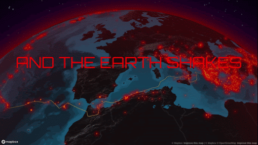
And the Earth Shakes is an interactive storymap which explores the location and magnitude of earthquakes around the world since 1900. The map and data visualizations were created by the atlo data journalism team using data from the United States Geological Survey. 

The first part of And the World Shakes uses an interactive globe to show the locations of around 37,000 earthquakes which have occurred since 1900. As you scroll through the article the globe takes you on a tour of some of the most impactful earthquakes of the last 123 years. These include the recent earthquake to hit Turkey and Syria, the largest recorded earthquake (May 22 1960 in Chile), the 9.2 magnitude earthquake which hit Alaska on March 28 1964, and the San Francisco earthquake of April 18, 1906.

You can explore all post-1900 earthquakes greater than magnitude 5.5 on the interactive map yourself by using the filter controls which appear when you reach the end of the map presentation. These controls allow you to filter the earthquakes shown on the globe by year, strength and tectonic plate.

The second half of And the World Shakes explores the strength and depth of post-1900 earthquakes. The article also takes time to explain what causes earthquakes to occur and the nature and effect of their shockwaves.

And the Earth Shakes is in Hungarian. However the data visualizations in the article are fairly self-explanatory and the whole site can be read in English using the 'translate' option in the Chrome browser.

Friday, March 10, 2023

Earthquakes - Global Risk & Hazard Maps

The Global Earthquake Model Foundation is a non-profit organization working to assess and help manage the risk from earthquakes and seismic activity around the globe. Part of its mission is to is assess and share open data on earthquake risks and hazards.

The Global Earthquake Model Foundation has released two interactive maps, the Global Seismic Risk Map and the Global Seismic Hazard Map, which can be used to explore the risk from earthquakes at locations around the world. The estimated hazards are based on the foundation's own OpenQuake engine, an open-source seismic hazard and risk model.

I think the main difference between the two earthquake maps is that the hazard map visualizes earthquake hazards based on seismic faults around the world, while the risk map is based on likely damage and risk assessments. In other words the hazard map shows the estimated ground effect of an earthquake and the risk map shows the potential damage to buildings at that location from seismic activity.

Global earthquake hazards can also be seen on ResourceWatch's Global Earthquake Hazard Frequency and Distribution map. This interactive map visualizes all earthquake activity around the world, from 1976 to 2002, exceeding 4.5 on the Richter scale.

You can also explore historic earthquake data on the Seismic Explorer. The Seismic Explorer interactive map visualizes 40 years of earthquake activity on Earth, including information on the magnitude, depth, and location of each recorded quake. The map uses data about recent seismic activity from the United States Geological Survey (USGS), and data from the Smithsonian Institution Global Volcanism Program on historical seismic activity around the world.