Showing posts with label awards. Show all posts

Tuesday, April 08, 2014

Google Maps at the Webby's

There are only 16 days left until this year's Webby Awards. As ever Google Maps features prominently in a number of the nominated websites. Here are just a few of our favorite websites that are contenders for this year's awards.

 
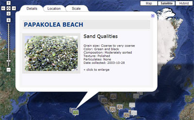
Find a Spring is a community driven database and Google Map of natural springs around the world. If you select a spring's map marker you can view details about the spring and the map zooms in to show a satellite view of the spring.

Users of Find a Spring can add locations of springs that don't already appear on the map.

Vote for Find a Spring.


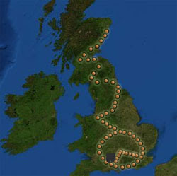
The Nature Valley Trail View is a beautiful map of trails in some of America's national parks. The map includes a number of trails, each of which can be experienced with a glorious animated custom Street View tour. If you click on the menu link you can select any of the trails and then virtually walk the trail with custom Street Views of the whole trail.

Each tour includes an option to animate a walk on the trail, so you can just sit back and watch as you walk the trail with custom Street Views. Below the Street View is an altitude graph and a compass rose is also provided.

Vote for Nature Valley Trail


Last year Google Maps, the U.S. Geological Survey, NASA and TIME came together to release an awesome new interactive timelapse application for viewing satellite images of the Earth.

Timelapse allows you to create a timelapse sequence from satellite images (from 1984 to 2012) for anywhere on Earth.The application comes with a number of default views that allow you to view timelapse animations of satellite images showing the sprawling growth of Las Vegas, the building of Dubai, the shrinking of the Mendenhall Glacier and the drying-up of Lake Urmia.

Vote for Timelapse


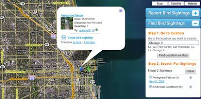
Roadtrippers is a Google Maps based trip planner. The application allows users to get driving directions between two locations in the U.S. and find points of interest along the route.

Using Roadtrippers it is possible to search for places of interest and good places to eat, drink and shop along a planned drive. You can search for points of interest in a large range of categories, including 'attractions', 'accommodation', 'shopping', 'food and drink' etc.

If you like the look of one of the recommended points of interest you can easily add it to your trip and the application automatically adds the stop to the finished driving directions.

Vote for Roadtrippers


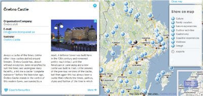
In October of last year Visit Victoria launched a five day campaign to promote the city of Melbourne. Melbourne Remote Control Tourist allowed potential tourists around the world to experience the city online in real-time by controlling and directing a number of remote controlled tourists around Melbourne.

The remote controlled tourists were kitted out with helmet-mounted cameras and could be instructed where to go and what to visit via Twitter and Facebook. The Melbourne Remote Control Tourist website included live broadcasts of the video and audio feeds from the remote controlled tourists.

The campaign has now finished but you can still view selected videos captured during the five days. You can also explore the Remote Control Tourist Google Map of Melbourne which features a categorized selection of the city's best restaurants, bars, cafes and sights

Vote for Remote Control Tourist

Wednesday, April 22, 2009

Webby Nominated Maps

Isn't it time that the Webby Awards created a Best Use of Maps or a Location Aware category? Four of this year's Webby nominees are mapped based websites and of course many of the other websites, particularly in the travel and real estate categories, feature maps somewhere in their service.

Sandrific.com

Sandrific.com is a nominee in the Personal Web Site category and is a great example of how Google Maps can be used to help share a personal passion with the world. The website features mapped photos of sand collected by Betsy Kimak.

With the help of family and friends, who have brought sand back from their vacations, Betsy has amassed a collection of sand from beaches all over the world. Using Google Maps and Slimbox, Sandrific.com has created an attractive interface to present geo-tagged photographs of her large sand collection.

Britglyph
Britglyph is a nominee in the Net Art category of the Webby's. I had the pleasure of meeting Alfie Dennen, one of the brains behind Britglyph, earlier this year. To my eternal shame I have told Alfie at least twice of my eagerness to review Britglyph on Google Maps Mania, and both times I have promptly forgotten to actually do so.

Britglyph is an amazing collaborative art work in which 61 people carried a rock to 61 locations in the UK, they then took a photograph of themselves with their rock and then sent it in to the site with the GPS location of the photograph.

The result is an incredible image of a timepiece drawn on top of a map. The finished art work is a symbolic representation of John Harrison's Marine Chronometer H5, the tool which effectively solved the Longitudinal problem.

Birdpost
Birdpost Map
Birdpost is nominated in the Social Networking category. We first featured Birdpost on Google Maps Mania in October of last year. The site is designed to allow bird watchers to report bird sightings and find the bird sightings of other bird watchers.

You can use Birdpost's Google Map to either report bird sightings or find out about bird sightings in a particular area. To add a bird sighting the user just double clicks on the map and completes a short form. To find sightings the user just types a location into a search box. The map then centres on that location and shows previous sightings with blue markers on the map and lists the birds in a side panel.

Bird watchers can also use Birdpost to create an on-line chronicle of the birds they have seen, share their chronicles with other Twitterers, connect with other bird watchers and create e-mail alerts for sightings of rare birds.

VisitSweden


VisitSweden is nominated for a Webby in the Tourism category. VisitSweden was first featured on Google Maps Mania back in 2007 and is Sweden's official website for tourism and travel information.

VisitSweden has created Google Maps for each of Sweden's main regions. The maps each have a number of layers that can be selected to find interesting places to visit in the country. The layers include Culture, Family vacation, Nature experiences, Outdoor activities, Gastronomy, Coastline experiences, Wellness, Design and Airports.

______________