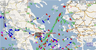
Real-Time Ship Tracking on Google Maps
MarineTraffic.com

MarineTraffic.com have produced a Google Map showing real-time information about ship movements throughout the world.
The system is based on AIS (Automatic Identification System). The International Maritime Organization (IMO) requires all vessels over 299GT to carry an AIS transponder on board, which transmits data on position, speed and course, among some other static information, such as the vessel’s name, dimensions and voyage details.
MarineTraffic uses this information to plot the real-time position of marine vessels on a Google Map. The vessels' positions are shown on the map by tags in the shape of boats. The tags are colour-coded to show whether the vessel is a tanker, passenger vessel, cargo vessel, yacht etc. Clicking on a tag brings up a wealth of information about the vessel and its current destination.
MarineTraffic say they can expand their coverage to include any area worldwide. Anyone can install a VHF antenna, an AIS receiver and start immediately sending and seeing data on the map.
Other Marine Maps
- Hi-Def San Francisco -real-time ship tracking in the San Francisco Bay
- Isle of Wight Live Ship Tracking - live tracking of ships around the Isle of Wight
- Live Piracy Map 2008 - A piracy map created by the International Chamber of Commerce purports to show all the piracy and armed robbery incidents during 2008.
- Bluemapia - Bluemapia is a boating social network built around Google Maps.
- World Port Source - Interactive satellite images, maps and contact information for hundreds of ports throughout the world.


Комментарии
the job is nice but forbidden!
according to imo rules, these data can't be published and the reason is very simple: the ship's security - don't forget why the a.i. system was introduced
So I guess it depends on how close ships hug the Somalian coast.
The precious info is when and where the ship has been seen for last time. The site is free, requires registration only