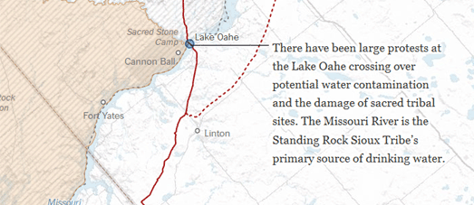
The Dakota Access Pipeline Map

The Dakota Access Pipeline is being built from the Bakken oil fields in North Dakota to southern Illinois. The pipeline will be nearly 2,000 miles long and travel through four states. When completed the pipeline will be able to deliver up to 570,000 barrels of crude oil every day.
The construction of the pipeline has become increasingly controversial, mainly because of its likely impact on the environment. Much of this controversy has been centered on the potential threat to the water quality on Native American tribal lands.
Cooper Thomas has released an Esri Story Map showing the route of the Dakota Access Pipeline. In Oil, Water and Steel Cooper explores the necessity of the pipeline, discusses the safety of different oil transportation methods and explores the controversy around the pipeline's construction.
As you scroll through Oil, Water and Steel you are taken on a journey along the pipeline's route. During this journey important locations on the pipeline's route are picked out on the map. In particular you can learn more about the most controversial locations on the pipeline's route and where and how the pipeline's construction is being contested

The New York Times has also mapped the pipeline's route. In Conflicts Along the Dakota Access Pipeline the Times has created an impressive strip map of the pipeline and the locations which have seen the most controversy over its construction.
Locations where the pipeline has to cross water are marked with blue circles on the map. Small yellow circles show where land in Iowa was purchased under eminent domain. The NYT's map uses data from The Bakken Pipeline Map, which includes much more detailed information on the progress of the pipeline's construction and the properties it crosses, properties purchased under eminent domain and property owners legally contesting eminent domain.


Комментарии