Make Your Own Map Posters

Maposaic is a fun interactive tool for creating your own colorful maps. The application is being marketed as a way to create random colorful map mosaics. However Maposaic has a number of settings which can be adjusted that allow you to choose your own colors and map any location in the world.
At the heart of Maposaic are Mapbox's customizable vector map tiles. The Mapbox API allows users to adjust the styling and colors of the underlying map data on the fly. This means that Maposaic can offer a clever tool which allows users to change the map's colors and create their own colorful map designs.
In the settings menu you can enter a location to create a map of your favorite town, city or neighborhood. In the 'Colors' section of the settings menu you can choose 'random' colors or choose your own palette of colors. When you have created a map design that you can like you can then download and save the map as a printable image. You can also upload your map design to the Maposaic gallery of maps.
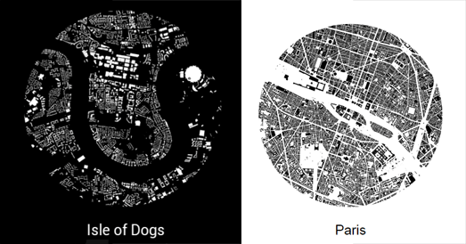
You can also create your own map posters using Hans Hack's Figureground Posters. Figureground Posters is an easy to use tool for creating map posters using OpenStreetMap data.
To create your poster simply click on the Figureground Posters interactive map to select the location that you want. You can then
select a size for the area that you wish to map. Figureground Posters creates circular maps so just choose the radius size that you wish to map (up to 2000 meters). When you are happy with your chosen location and radius size just click 'Make Poster'. Figureground Posters will then create a simple map of your selected area using the building footprint data from OpenStreetMap.
Once you've created your map you can then add a place-name (or any other text to your map). You can also choose between showing your map as black building footprints on a white background or white building footprints on a black background. That's it. You can now download your finished map poster as either a SVG or PNG image.
Street Patterns is another great tool for making map posters. The tool also uses data from OpenStreetMap to create small circular images consisting of just the street map of your chosen location.
Street Patterns doesn't only help you create your own map posters it also explains the whole process it uses in creating these Street Pattern maps. So while using Street Patterns to create your own map poster you also learn a little about how to use Overpass Turbo and Turf.js.


Комментарии