The Last Frost of Winter

NOAA has released an interactive map which uses historical temperature data to map the Average Date of Last Spring Freeze Across the United States.Using the map you can view the last day on average when there is a chance for freezing temperatures at thousands of locations across the whole country.
NOAA's last spring freeze map uses temperature data from 1991-2020 captured from weather stations across the United States. The colored dots on the map indicate the average date on which the chance of freezing temperatures drops below 50 percent at each location. If you click on a dot on the map you can view the actual date of the average last frost for the selected weather station. Shades of purple are used for locations where the last frost normally occurs before the first day of spring (in mid-March). Weather stations colored with a shade of green indicate locations where the last frost usually comes after the first day of spring.
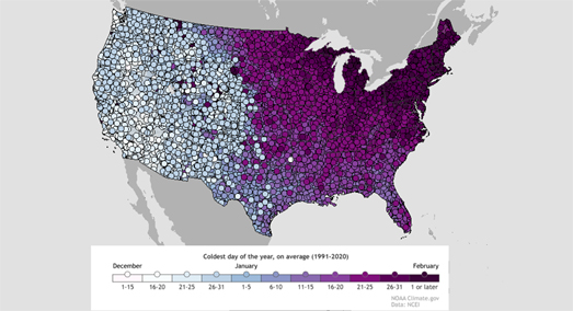
You can discover when your coldest day of the year is likely to occur (on average) on NOAA's interactive map Coldest Day of the Year on Average. On this map weather stations across the United States are colored to show when on average in the year they have experienced their coldest day. These dates are calculated using data from the National Centers for Environmental Information (NCEI). The specific data used is the average low temperature for every day from 1991-2020. You can also click on individual weather stations on the map to view the exact date for the coldest day of the year on average at that location.
Just from looking at the screenshot of the map above you can see that the coldest day of the year normally occurs later in the season in the East than it does in the West of the country. This is partly due to when cold air from snow-covered areas of Canada is blown down into the East. In the Western half of the United States the coldest day usually occurs in December. In the Eastern half of the country the coldest day usually arrives in January or February.
If you want to know when the first snow of the year is most likely to fall then you can refer to NOAA's handy interactive First Snow Map. This map provides a nationwide guide as to when you can expect to get the first snow of the winter. The map shows the date at your location when the chance of snow is at least 50%, based on historical weather records (1981-2010).
Your latitude and altitude play the biggest role in determining when you are most likely to experience snow. On average the more northerly you are and the higher your altitude then the earlier you are likely to see snow.
If all this talk of snow and low temperatures leaves you feeling cold then you might want to look forward to when you can expect your hottest
day of the year. NOAA's Warmest Day of the Year map shows the warmest day of the year on average across the United States based on temperature data from 1991-2020. In most of the country
the hottest day normally occurs between mid-July and mid-August.


Комментарии