How to Make Your Own Pretty Map Posters
I made the map poster above using a new map poster creation tool called prettymaps. prettymapp is a web app which you can use to create pretty map images for any location on Earth.
Prettymapp is an online interactive version of @marceloprates' pretty maps project. The original 'pretty maps' project is a Python library to draw customized maps from OpenStreetMap data. The new prettymapp app uses this library to create an actual online tool for making your very own pretty map images.Prettymapp is very simple to use. Simply enter an address and press the 'submit' button and prettymapp will automatically create a map poster centered on your location (you can type in a latitude,longitue instead of an address to give a precise location). The tool includes a number of options for changing the design of your final map. These allow you to choose your own colors for individual map features, such as the color of water, grassland and roads. There are also options for customizing the size and placement of the title of your map.
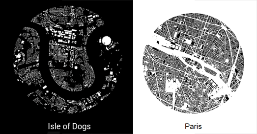
Hans Hacks' Figureground Posters is another fun tool for creating map posters from OpenStreetMap data. To create your poster simply click on the Figureground Posters interactive map to select the location that you wish to work with. You can then select a size for the area that you want to map.
Street Patterns is another great tool for making map posters. The tool also uses data from OpenStreetMap to create small circular images consisting of just the street data of your chosen location.
Street Patterns doesn't only help you create your own map posters it also explains the whole process it uses in creating these Street Pattern maps. Therefore while using Street Patterns to create your own map poster you can also learn a little about how to use Overpass Turbo and Turf.js to download and use OSM map data.
Hans Hacks' Figureground Posters is another fun tool for creating map posters from OpenStreetMap data. To create your poster simply click on the Figureground Posters interactive map to select the location that you wish to work with. You can then select a size for the area that you want to map.
Figureground Posters creates circular maps so just choose the radius size that you wish to map (up to 2000 meters). When you are happy with your chosen location and radius size click 'Make Poster'. Figureground Posters will then create a simple map of your selected area using the building footprint data from OpenStreetMap.


Комментарии