

Gibraltar (left) compared to Central Park (right)
Same Scales is an interactive map which allows you to compare two different locations side-by-side at the same scale. Comparing locations on the same map can be difficult because of the distortions caused by map projections. Same Scales helps you compare two different locations by showing each at the same scale on two different maps placed side-by-side.

Africa (left) compared to Greenland (right) on the same map
Famously Greenland and Africa appear to be similar in size on maps which use the Mercator projection. The Mercator projection is commonly used in many world maps because it accurately represents direction and shape. However, it distorts the size of land areas the further they are from the Equator.
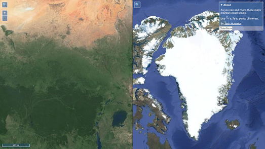
A small part of Africa (left) compared at the same scale to Greenland (right)
If you are interested in comparing the sizes of different countries with each other then you can also use The True Size Of interactive map. The True Size Of app allows you to overlay the shape of one country on top of an interactive map. You are then able to select and drag this country polygon around on the map in order to compare its size with any other location on Earth.
1 comment:
One way to accomplish a side-by-side size comparison could be for each map to use the same projection centered on that location. For example, both the African and Greenland maps could use the same equal-area or conformal projection, centered at the geographic centers of each land mass. I don't know if any of this is possible; I wish I'd studied map datums (data?) and projections more closely!
Post a Comment