Friday, February 28, 2025

The Battering School Kids Map

I was horrified to learn today that not only is corporal punishment legal in most of the U.S., but 20 states even allow schools to physically punish young children. The U.S. States Where Corporal Punishment is Allowed - IDRA Map shows where schools are permitted to use corporal punishment and also details how many schoolchildren have been subjected to it.

The map was created by the Intercultural Development Research Association (IDRA) using data from the U.S. Department of Education from 2017-2018. A data dashboard of the corporal punishment incidents carried out in this year is also available.

According to the data, approximately 70,000 children were physically punished during the 2017-18 school year. Mississippi reported the highest number of students hit, with 20,388 pupils beaten. Texas (14,264 students beaten) and Alabama (9,174 students beaten) recorded the second and third highest numbers, respectively.

Upon first viewing the IDRA Map (shown at the top of this post), I was immediately reminded of U.S. "Black Belt" maps. It is, therefore, unsurprising to learn from the IDRA that in 2017-2018, "the rate of corporal punishment of Black students was twice as high as that of their white peers." The IDRA also reports that students "with disabilities experience higher rates of corporal punishment than their peers without disabilities."

Thursday, February 27, 2025

It's a Scrambled World

If you're a fan of map-based puzzles, there's exciting news for you - Scrambled Maps has evolved into something bigger and better! 

Scrambled World, is a major new version of Scrambled Maps that expands the game beyond its classic format and introduces a host of new features designed to enhance your puzzle-solving adventure.

What is Scrambled Maps?

For those unfamiliar, Scrambled Maps is a game where map tiles are jumbled up, and players must rearrange them to form an accurate representation of a city, state, or country. Think of it as a jigsaw puzzle, but with real-world maps! The challenge lies in piecing together the correct layout in as few moves as possible.

What's New in Scrambled World?

Scrambled World takes the original Scrambled Maps concept and turns it into a comprehensive global experience. Here are some of the biggest additions in this update:

🌍 1. A Unified Gaming Platform

Scrambled World integrates both Scrambled Maps and Scrambled Hex Maps, giving players the choice between the traditional square-based layout and a more complex hexagonal variation. This means more flexibility and a fresh challenge for puzzle enthusiasts.

🎯 2. Progress Tracking on a Global Scale

One of the best new features in Scrambled World is the ability to track your progress. A new world map interface lets you visually track how many Scrambled Map games you have solved. Successfully unscrambled cities will be marked in green, providing a satisfying way to see your accomplishments. Plus, by signing in with your Google account, you can sync your progress across multiple devices - and never lose track of where you left off!

🔄 3. Customizable Objectives

Want to focus on specific regions? Now you can! Choose to master all cities within a country or, if you're in the U.S., concentrate on completing cities within a particular state. This feature makes gameplay feel more structured and goal-oriented.

🔍 4. Enhanced City Selection

Finding your next challenge is easier than ever with multiple ways to select cities:

  • Search for a specific city
  • Click on the world map to discover nearby locations
  • Use the random city selector for a surprise challenge
  • Follow the featured city of the day for a guided experience

🔄 5. Flexible Game Settings

Whether you prefer the classic square grid or the more advanced hexagonal layout, Scrambled World lets you switch between them seamlessly. You can also adjust grid sizes to match your skill level - perfect for both beginners and advanced players.

🗺 6. Explore Mode

Once you've completed a puzzle, switch to Explore mode to view an interactive map of the game area. This is a fantastic way to learn more about the cities and regions you've been solving!

Performance Improvements & Future Plans

Currently Scrambled World includes games for over 11,000 locations around the world, focusing on major population centers and historically significant places. 

Looking ahead, we are hoping to also include custom puzzle creation - which will allow players to generate map challenges for any location on Earth (and possibly beyond!).

Stay Connected & Share Your Thoughts

We value your feedback about the game - and so a new support messenger system has been added. This can be accessed via the envelope icon in the top left corner of the screen. Whether you have suggestions, encounter technical issues, or simply want to share your thoughts, we want to hear!

Ready to Start Your Puzzle Adventure?

With all these new features, Scrambled World is more engaging than ever. Whether you’re a longtime fan of Scrambled Maps or a newcomer looking for a fun way to test your geography skills, there’s never been a better time to dive in.

Start playing today on the original Scrambled Maps or take on the world by playing the new and enhanced Scrambled World - and see how many cities you can unscramble!

Wednesday, February 26, 2025

The Best & Worst Countries in the World

This map reveals how people perceive each country on Earth. The snappily entitled Sentiment Different Ratio by Country visualizes global public sentiment based on comments from the popular social media platform, Reddit.

According to an analysis of 444,059 Reddit comments, Laos, Iceland, and Slovenia are the most highly regarded countries in the world.

On the other hand, Palestine, Israel, and Qatar receive the most negative sentiment. These three countries have the highest concentration of negative comments among the 444,059 Reddit posts analyzed.

You can explore the study’s methodology and findings in more detail in the blog post Country Recognition and Geolocated Sentiment Analysis Using the RoBERTa Model. In addition to the interactive map above, the post includes maps highlighting the Positive Sentiment Ratio and Negative Sentiment Ratio of each country.

For reference, the United States has a Sentiment Difference Ratio of -0.2835541, ranking it as the 17th worst country in terms of negative sentiment.

According to the author's conclusions, the countries with the highest positive sentiment ratios "share characteristics like a high quality of life, natural beauty, political stability, a discreet presence in international politics, or popularity as tourist destinations". Conversely, nations with "internal conflicts, restrictions on civil liberties, humanitarian crises, or recent political developments, can contribute to a widespread negative perception". 

Tuesday, February 25, 2025

Colonial Frontier Massacres

In 2017, the University of Newcastle in Australia released an interactive map of Colonial Frontier Massacres in Central and Eastern Australia 1788-1930. The map is part of the university's efforts to record and document the massacre of over 10,000 Native Australians between 1788 and 1930.

The eight-year-long project to document the massacres of First Nations people in Australia has now ended. The university's research into colonial frontier massacres actually concluded in 2022. Since then, every site on the map has been fact-checked and peer-reviewed to ensure its accuracy.

The map makes for harrowing reading. In just one example, it records how, on May 1, 1838, at Slaughterhouse Creek, fifteen heavily armed stockmen attacked and killed 300 Kamilaroi Aboriginal people. The massacre occurred just four months after 50 Kamilaroi people were killed by police at nearby Waterloo Creek.

The Guardian has now updated its The Killing Times interactive map. The Guardian map  incorporates data from the University of Newcastle alongside The Guardian's own research, which was conducted using the university’s methodology. The Guardian's map now includes the final peer-reviewed data from the Colonial Frontier Massacres project.

Like the university’s map, The Guardian's map features a timeline that allows users to filter massacres by date range. It also enables filtering by the number of victims and by perpetrator groups. Clicking on a marker on the map reveals additional details about the selected mass killing beneath the map.

Also See

Map of White Supremacy’s mob violence, 1848 - 2021 - an interactive map of lynchings against Black Americans

Monday, February 24, 2025

2025 German Election Maps

The conservative CDU party emerged as the biggest winner in yesterday's German election. Another clear winner from Sunday's vote was the far-right AfD party, which doubled its vote share to 20.8%. Meanwhile, the center-left SPD (the party of incumbent Chancellor Olaf Scholz) suffered its worst-ever results, securing just 16.4% of the national vote.

The Berliner Morgenpost's Federal Election 2025 Results includes an interactive map visualizing the winning party in each electoral district. This "winner-takes-all" view highlights a stark contrast between the results in former East Germany and the rest of the country. In nearly all West German regions, the CDU emerged as the most popular party. However, in almost all of former East Germany, the extreme far-right AfD was the dominant party.

Zeit's 2025 Election Results map uses a similar shaded margin layer to illustrate the election results. Both maps employ party colors to represent the winning candidates in each electoral district, while also using varying shades to indicate the strength of each party's winning margin.

On both maps, users can click on individual electoral districts to view the percentage of votes won by each political party in that area. Additionally, the Berliner Morgenpost map allows filtering by individual party. For example, selecting the far-right AfD reveals how well they performed across Germany—confirming that the party fared significantly worse in former West German regions compared to areas of former East Germany.

Tagesspiegel's Federal Election 2025 map also includes options to view both 'first' and 'second' votes and to view maps of all German elections dating back to 1990. The first vote is used to determine the candidate who will represent the constituency. The second vote is used for each party's state list. 

About half of the Bundestag consists of directly elected candidates (determined by the first votes). The rest of the seats in the Bundestag are determined by the proportion of second votes won by each party. The total number of seats a party gets is determined by the share of the second vote it receives (as long as it surpasses the 5% threshold or wins at least three direct mandates). Each party then fills these seats using candidates from its state party lists.

Saturday, February 22, 2025

2024 - Another Year of Record Heat

Last year, two-thirds of the Earth’s surface experienced at least one month of record-breaking heat. The Guardian has visualized data from the Copernicus Climate Change Service to illustrate the average temperatures around the world for each month in 2024.

The animated map at the top of the article comes from The Guardian's feature,  Two-thirds of the Earth’s surface experienced record heat in 2024. See where and by how much – visualised. The map displays the number of degrees (Celsius) by which previous monthly temperature records were surpassed worldwide from January to June 2024. As the article states, throughout the year, "65% of the world’s surface recorded at least one month hotter than scientists had ever previously observed there."


The Guardian's visualization of Copernicus Climate Change Service data allows users to explore where and when previous temperature records were broken in 2024. For example, in September, parts of China exceeded previous temperature records by more than 5°C. In August, temperatures in Antarctica were up to 6.5°C above the previous record.

The Paris Agreement of 2015 set a target of limiting global warming to 1.5°C by the end of the century. However, The Guardian reports that the world is now on track to reach 2.7°C of global heating. A rise of 2.7°C could lead to more frequent and intense extreme climate events - such as heatwaves, wildfires, and hurricanes - while accelerating polar ice melt will lead to rising sea levels, threatening coastal communities and ecosystems worldwide.

Friday, February 21, 2025

Zoom, Pan, and Explore: Sutro Tower in 3D

Vincent Woo has released an astounding 3D model of Sutro Tower in San Francisco. Sutro Tower in 3D is a fully interactive representation of the city's 977-foot (298-meter) tall radio and television transmission tower. The model was created using thousands of aerial images of the tower, all captured by drone. These images were then processed into a fully interactive 3D model, thanks largely to Gaussian splatting

Because the model is interactive, you can fly around the tower and zoom in and out to examine any detail of the 977-foot-tall structure. It even includes interactive markers that, when clicked, provide information on various features of the tower.

If you want to experience the views from the top of Sutro Tower, you can explore three gigapixel images taken from the tower by Explore Sutro Tower. These annotated images offer a panoramic view of San Francisco as seen from the tower’s peak. Explore Sutro Tower also provides a guided tour featuring its own detailed 3D model of the transmission tower.

For those interested in exploring 3D models of other locations around the world, check out SuperSplat. SuperSplat is a free, open-source, browser-based tool designed for inspecting, editing, optimizing, and publishing 3D Gaussian Splats. Its homepage showcases hundreds of 3D models uploaded by its community of users.

Thursday, February 20, 2025

How Climate Change is Destroying Crops

world map with 100 colored markers showing the locations where crops have been destroyed by extreme weather. The colors of the markers are related to the type of weather event responsible for the destruction

Carbon Brief has analyzed global media reports to identify where and how extreme weather events have destroyed crops over the past two years. In How Extreme Weather is Destroying Crops Around the World, Carbon Brief has mapped this analysis, highlighting 100 instances of crops being lost to heat, drought, floods, and other extreme weather events in 2023-24.

The colors of the 100 markers on the map indicate the type of extreme weather event responsible for the destruction. Some markers are multi-colored, representing "compound" events where crops have been affected by more than one extreme condition - for example, frost and drought impacting grain yields in South Australia.

With only 100 data points, the Carbon Brief analysis is likely too limited to draw definitive conclusions about how different extreme climate events are affecting crops in various regions. However, the map effectively illustrates the growing challenges faced by the agricultural sector due to climate change and global warming. As climate change intensifies, agriculture worldwide faces mounting threats, and the Carbon Brief map underscores the urgent need for adaptation strategies to ensure food security.

Wednesday, February 19, 2025

The Best (and Worst) Cities for Rail Transport

maps of London and New York with rail lines and population density visualized
London & New York - population density and railways

The citizens of Hong Kong have the best rail transport system in the world according to a new study by the University of Toronto. Osaka, Japan, and Madrid, Spain, rank second and third, respectively, while New York ranks highest among U.S. cities.

The University of Toronto's School of Cities analyzed how well the world's 250 most populated cities provide rail transit for their residents. The ranking is based on the percentage of each city's population that lives within 1 km of a rail station. In essence, the study measures how many people have convenient access to rail transit.

You can view the result for yourself on the University's Rail Transit & Population Density website. The interactive visualization allows you to compare maps of any two cities and see what percentage of their populations have easy access to rail. Each city's map displays population density overlaid on its rail network, with a breakdown beneath showing the share of residents living within 1 km of a major rail station.

The School of Cities highlights two main limitations in their analysis. The rankings focus solely on rail transit, excluding other public transportation systems that may offer comparable service, such as bus networks. Additionally, they do not account for service frequency, a key factor in the overall effectiveness of transit systems.

Via: Data Vis Dispatch

Tuesday, February 18, 2025

Before New York

an animated 3D model of New Amsterdam showing two windmills, panning ans zooming to the wooded city walls

This is New Amsterdam in 1660, when Peter Stuyvesant was serving as the director-general of the colony of New Netherland. New Amsterdam, located on the southern tip of Manhattan Island, was the capital of New Netherland.

One of my favorite interactive maps of all time is the Beyond Manhatta. This project visualizes Manhattan Island and its native wildlife, as it would have looked in 1609. The Beyond Manhatta map allows you to explore New York's original natural landscape of hills, valleys, forests, wetlands, salt marshes, beaches, springs, ponds and streams. 

Thanks to the New Amsterdam History Center, we can now travel forward half a century to explore Manhattan after it had become a Dutch colony, administered and governed by the Dutch West India Company.

The New Amsterdam 1660 3D model (shown above) was created by the New Amsterdam History Center for its Mapping Early New York collection, which features maps and documents of New Amsterdam and New Netherland. This model allows you to explore the settlement’s houses, farms, taverns, and workshops, as well as its surrounding walls. It was developed based on the Castello Plan, a map of the settlement created in 1660 by Jacques Cortelyou.

You can view the original Castello Plan itself on the Mapping Early New York interactive map.

Monday, February 17, 2025

The Gulf of Kleptocracy

map with the Gulf of Mexico renamed to the Gulf of Kleptocracy
Apple Maps has joined Google Maps in kowtowing to the maggot infestation of U.S. geopolitical policy. This means you might want to bookmark OpenStreetMap, Bing Maps or Mapquest, - who now seem to be the only interactive map providers still interested in maintaining geographical accuracy.

As well as continuing to use the correct place-name label for the "Gulf of Mexico," MapQuest has also released a fun new tool that lets you participate in Google’s and Apple’s new era of crap maps. MapQuest's Name Your Own Gulf allows you to play at being an appeaser to a corrupt, incompetent U.S. president yourself.

With Name Your Own Gulf, you can spend your whole day renaming the Gulf of Mexico to whatever you want. Just enter a new name, and the interactive map will automatically update to display your latest crazy misnomic place-name label. Feeling lazy (or running out of ideas), then simply press the "Surprise Me" button to see the Gulf of Mexico randomly renamed.

If you want to take your deranged despot cosplay to the next level, you can even head over to X in the middle of the night and send demented tweets containing unique URL links to each of your crazy Gulf of Mexico names.

map showing the Gulf of Mexico with every location in the USA and Mexico renamed 'United States'

If you still have a few minutes to kill, you can also play my Where's the Gulf of Mexico? game. This game imagines a world where Google and Apple have taken their new MAGA mapping policy to its logical conclusion - renaming every location in the world "United States." However, the Gulf of Mexico has gone into hiding, still remaining somewhere among the thousands of "United States" place-name labels. You have just 60 seconds to find the Gulf of Mexico and report it to Google's ICE (Imaginary Cartographic Edits) team of enforcement agents.

Saturday, February 15, 2025

The Black History Month Map

The Black History Month Map is a new collaborative and dynamic map developed by kinkofa and PamPam to honor and document the significant places, individuals, and movements that have shaped Black history. To help you explore the invaluable contributions of Black Americans to U.S. history, the map is powered by PamPam's "Ask Pam" AI assistant.

The Black History Month Map allows you to discover and learn more about the places, people, and movements that have influenced Black history in the United States. To navigate the vast amount of information available, you can use the categories and themes highlighted in the map’s sidebar. For example, selecting "Movements" will filter the map to display significant movements in African American history and their associated locations.

Additionally, the "Ask Pam" AI assistant enables you to search and filter results with ease. For instance, you could ask "Show me significant locations in the life of Martin Luther King" or "Highlight key locations in the Underground Railroad," and the Black History Month Map will automatically display relevant results both on the map and in the sidebar.

The Black History Month Map is more than just a collection of locations - it is a living archive that invites everyone to participate by adding significant events, individuals, and landmarks. As more people explore and contribute, the map will continue to expand, creating an ever more comprehensive record of Black history.

Also See

The Sundown Town Map - mapping the locations of sundown towns across the USA
The Legacy of Redlining - exploring the HOLC's redlining of American towns and cities
Visualizing Emancipation - a map of slavery’s end during the American Civil War

Friday, February 14, 2025

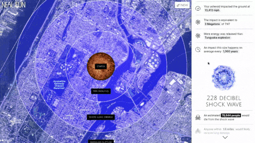
What If Asteroid 2024 YR4 Hit Your Town?

an animated map visualizing a 1 mile fireball superimposed on New York

According to NASA, Asteroid 2024 YR4 has a 2.3% chance of impacting Earth on December 22, 2032. The asteroid is estimated to be between 40 to 90 meters (130 to 300 feet) in diameter.

If you want to know what damage Asteroid 2024 YR4 might cause if it lands in your backyard, you can use Neal.Fun's Asteroid Launcher to find out.

According to Neal.Fun's Asteroid Launcher, if a 200-foot diameter rock asteroid hit Manhattan at 38,000 mph at a 45-degree impact angle, it would cause a fireball almost 1 mile in diameter. As a result of the fireball, 3,671,280 people would die, and an estimated 2,904,736 people would receive third-degree burns. Homes within 8.2 miles of Manhattan would collapse, and nearly all the trees within 8.8 miles would be knocked down.

Neal.Fun's Asteroid Launcher is an interactive map that allows you to visualize the impact and effects of an asteroid hitting the Earth. The map allows you to define the size, composition, speed, and impact angle of an asteroid and then choose where on Earth the asteroid will hit. Once you have chosen an impact location, you can view information on the predicted width and depth of any impact crater, as well as data on the number of people who would be vaporized in the crater or killed by the resulting fireball, shock wave, and wind blast.

While the current estimated impact probability of Asteroid 2024 YR4 is 2.3%, it is important to note that this figure is likely to change as additional observations and data are collected. Continued monitoring and analysis by NASA and other space agencies will help refine the asteroid's trajectory and provide a clearer understanding of any potential threat.

The chances of Asteroid 2024 YR4 hitting your town are very slim - there is probably more chance of a nuclear war. But don't worry, Bomb Blast Bomb Blast can show you the likely effects of a nuclear missile landing on your home.

Outrider's Bomb Blast interactive map allows you to choose from a range of different types of nuclear weapons and select whether you want to detonate it at ground level or as an airburst. You can then view the likely damage of the selected weapon hitting your town, visualized on an interactive map. The map shows the likely radius of the fireball, radiation, shock wave, and heat. It also provides an estimate of the number of fatalities and injuries that the selected nuclear weapon would cause to your chosen target.

Thursday, February 13, 2025

What is Your Ecoregion?

map showing the distribution of the northern giraffe in Africa

Ecotenet is an interactive platform that provides users with a unique map of ecoregions across the globe. The map focuses on ecological boundaries in order to provide users with an understanding of different types of ecoregion and their unique biodiversity.

One of the most compelling aspects of Ecotenet is its emphasis on ecoregions, which are defined by the World Wildlife Fund as a "large unit of land or water that contain distinct species, natural communities, and environmental conditions".

Click on any ecoregion on the map and you can read a general summary of the region's ecological characteristics and history. The ECO-651 Filter can be used to view the global distribution of various animal or plant species. For example the screenshot at the top of this post shows the distribution of the northern giraffe in Africa.

The species distribution data on Ecotenet is sourced from organizations such as the Global Biodiversity Information Facility, World Wildlife Fund, IUCN Red List of Threatened Species, USDA, and the Ocean Biodiversity Information System. This ensures that the data is both accurate and comprehensive, covering a wide range of species and their habitats.

Also See

Wednesday, February 12, 2025

The Flight of the Barn Swallow

This animated gridded occurrence map shows recorded sightings of the Barn Swallow in Europe throughout 2024. The Barn Swallow is one of Europe's most well-known migratory birds, undertaking a long-distance migration between its breeding grounds in Europe and wintering areas in Africa.

On the animated map, you can see Barn Swallows returning to southern Europe in late February and early March. During April and May, they spread northward into central and northern Europe, reaching the UK, Scandinavia, and even parts of Russia.

In August and September, the swallows begin their southward migration as insect availability declines. By late November, most Barn Swallows will have reached their wintering grounds in sub-Saharan Africa, in countries like Senegal, Nigeria, and South Africa.

This animated map of Barn Swallow sightings can be viewed on the EuroBirdPortal (EBP), a collaborative project that compiles and visualizes bird observation data from across Europe. The site integrates millions of records submitted by birdwatchers from multiple online platforms. EBP then creates animated, interactive maps that track bird distributions and movements over the course of a year, offering valuable insights into migration patterns, seasonal changes, and species distributions across the continent.

You can also explore European bird migration patterns on the Bird Migration Atlas. The Bird Migration Atlas is an interactive map that plots the migration patterns of over 300 bird species across two continents: Eurasia and Africa. The map integrates data from historical European ringing schemes and modern tracking technologies to provide a comprehensive view of migration routes across both continents.

You can explore the migration patterns of American bird species on the impressive Bird Migration Explorer. The Bird Migration Explorer is an interactive map that visualizes the migratory patterns of 458 bird species that breed in the United States and Canada. Using this map, you can explore the journeys of individual bird species and discover when different species are likely to migrate through your town or city in North America.

Tuesday, February 11, 2025

3D Print Your World

an animated GIF panning around a 3D rendering of the island of Bioko

The Topography Explorer is an interactive map that generates and allows users to explore 3D renderings of the Earth's surface.

Using the application, you can create your own 3D visualizations of watershed areas or predefined regions. The animated GIF at the top of this post is an example of a 3D visualization generated by the Topography Explorer. This animation shows a 3D rendering of Bioko, an island belonging to Equatorial Guinea.

The Topography Explorer includes dynamic URL addresses. For example, here is a direct link to the 3D visualization of the island of Bioko. Currently, the application does not provide the option to download data from created 3D visualizations.

The DEM Net Elevation API can also help you create your very own 3D terrain models for any location on Earth. DEM Net has a fantastic tool that allows you to generate 3D models simply by selecting an area on a map.

To create a 3D model using the DEM Net Elevation API, all you have to do is draw a square on an interactive map around the area you wish to model. Within seconds, DEM Net will generate a 3D model of your selected area. You can then rotate and zoom in & out on your model directly in the browser. Additionally, you can download the model in two different formats.

DEM Net offers several customization options, including:

  • A selection of different satellite imagery or map tile sources for your model.
  • The ability to adjust the height of your model to exaggerate elevation levels.
  • A choice of various elevation models to generate your terrain.

If you’d love to own a 3D model of your own neighborhood, you might want to try Tile Exporter. Unlike the Topography Explorer and DEM Net, this application does not generate topographical representations but instead creates 3D models of urban areas using building footprints from Mapzen maps.

The tool utilizes building height data from Mapzen’s vector map tiles, enabling you to create a 3D map of any neighborhood. Just enter an address into Tile Exporter, and you’ll see a 3D map of the location. You can also use the inset map to adjust the location by selecting adjacent map tiles.

Once you’ve found a 3D scene that you like, simply press the "Download" button to grab the .obj file. This file includes:

  • Building height data
  • Earth, water, and land-use layers of your selected map tile

Once you’ve downloaded your .obj file, all you need is a 3D printer to bring your model to life!

Monday, February 10, 2025

There's Something About Islands

There is something slightly old-fashioned about Obscure Islands I Find Interesting, which I find very endearing. In essence, it is a simple interactive map with a limited selection of just 16 interesting islands. However, there is a certain charm in its innocent delight in exploring the world—one that reminds me of why I first became obsessed with interactive maps.

Obscure Islands I Find Interesting takes you on a tour of some of the world's most unique and little-known islands. With a selection of just 16 islands, each accompanied by a brief but intriguing description, this site offers a delightful exploration of some of the most isolated and mysterious locations across the globe.

The islands featured on the map range from historical curiosities (like Pheasant Island, which changes sovereignty every six months) to geographical anomalies (such as the recursively nested unnamed island in Canada). Its simplicity is perhaps the map's greatest strength. For example, the minimalist interface, with “Next” and “Previous” buttons, allows for smooth browsing between islands, making it easy for users to navigate through the 16 'interesting' islands with minimal hassle.

One of the islands featured on Obscure Islands I Find Interesting doesn't actually exist. In 2012, scientists from the University of Sydney sailed to Sandy Island, an island that appeared on Google Maps in the Pacific Ocean. However, when they arrived at the location, all they found was open sea. Sandy Island didn't exist - it was a phantom island.

Phantom islands are fake islands that have appeared on maps for a period of time, only to be later removed when proven to be nonexistent. Most of these islands originated from reports by sailors exploring uncharted waters. Presumably, they were a mix of mythical tales and simple cartographic errors in positioning real islands on early maps.

One of the most impressive explorations of these imaginary places is Phantom Islands – A Sonic Atlas, an interactive map that takes users on a journey through some of history’s most famous phantom islands. Each island is marked on the map, and clicking on a location reveals the story behind its creation. You can learn when the island first appeared on an atlas, when it was last recorded on a map, and how it was eventually debunked. Press the "Cruise" button, and you'll be taken on an audio tour of all the phantom islands.

Friday, February 07, 2025

Godview AI

Godview is one of the most promising new AI-powered maps to have emerged in the past 18 months. It is an interactive map that allows users to perform geographical searches using natural language queries.

This week, Godview introduced an exciting new feature called "Discover." This addition enhances the user experience by enabling individuals to click on any location on the map and instantly access AI-generated insights about the area.

Discover

The Discover feature is particularly valuable for a wide range of users, from travelers and researchers to everyday individuals curious about their surroundings. For example, as I plan a trip to southern Italy, Discover should allow me to simply click on towns and cities in Puglia to identify which ones might be most interesting to visit. It could also help me pinpoint must-see attractions in the towns where I eventually decide to stay.

Or Don’t Discover

Unfortunately, Godview appears to be somewhat myopic, and its Discover answers can be geographically imprecise. For example, when I clicked on West Ham in London, I was informed that it was Wanstead—"a generally affluent area." While the two locations are only two miles apart, in a city like London, those two miles can make a world of difference (West Ham actually has one of the highest poverty rates in the UK). 

I encountered similar inaccuracies when clicking on towns and cities in southern Italy. For the large city of Bari, Discover provided an accurate and useful general description. However, for smaller towns in Puglia, the results were more inconsistent. Godview frequently defaulted to a broader description of the Puglia region rather than providing details specific to the town in question. In some cases, it even confused locations with nearby towns.

Final Thoughts

While Godview’s Discover feature has significant potential, it still has room for improvement in accuracy and precision. The issue may stem from imprecise reverse geocoding rather than the AI itself - perhaps the geocoding service Godview relies on is returning overly broad results. Alternatively, the language model (LLM) powering Discover may currently be limited to generating insights in some locations at a broad regional rather than a local level.

This also raises the question of user needs - something Discover does not yet fully address. Different users clicking on Greenwich Village in New York, for example, may be looking for entirely different levels of detail. One might expect a general overview of New York City, another may want specifics on the neighborhood itself, while a third could be interested in insights about a particular block or street.

Thursday, February 06, 2025

Jumbled Maps

a map of the world with all the country names mixed up
Introducing Jumbled Maps

Tripgeo has kindly agreed to host another of my map games, bringing geography enthusiasts a fresh and exciting challenge. If you love testing your knowledge of world maps and enjoy puzzles, then my latest game, Jumbled Maps, is perfect for you. 

In Jumbled Maps, someone has played a cosmic prank on the world map, and every country place-name label has been randomly displaced. Your mission is simple: restore geographical order by putting each nation back in its rightful place.

To play Jumbled Maps, click on any misplaced country label and type in its correct name. There are 249 countries in total to correct. Country names that you have successfully fixed will be shown with a green outline on the map and will also appear in the map sidebar.

How the Map Works

In essence Jumbled Maps is a very simple game. The game is powered by MapLibre, the flexible and open-source mapping library, with map tiles provided by OpenFreeMap, an open-source platform providing free custom map layers. These map tiles have then been custom styled using Maputnik to remove all country place-name labels from the map layer.

When the map loads, new country place-name labels are displayed on the map in randomly shuffled positions. These labels are retrieved from a GeoJSON dataset. This creates the core challenge of Jumbled Maps, as players must use their geographical knowledge to restore order.

The game also utilizes local storage to track a player’s progress. Any countries that have already been correctly identified are saved and excluded from future shuffles. This means you don’t have to correct all 249 country names in one session - you can return to the game at any time and pick up where you left off!

Also See

If you enjoy Jumbled Maps then you will also love Scrambled Maps, Tripgeo's daily map challenge. Scrambled Map requires you to unscramble the jumbled map tiles of a different city every day.

Wednesday, February 05, 2025

The Digital Twin's Digital Twin

an animated gif moving around a virtual model of the Punggol Digital District

The Punggol Digital District

The Punggol Digital District (PDD) is a pioneering smart district under development in Singapore. Designed to be a hub for innovation, it will house major technology firms, fintech hubs of banks like OCBC and UOB, and will be seamlessly integrated with the newly opened Punggol Coast MRT station. What sets PDD apart from other smart districts is its Open Digital Platform (ODP) - a centralized system that enables seamless connectivity between various technologies and services across the district.

Building an Open Digital Platform (ODP)

The ODP will serve as the district’s core digital infrastructure, facilitating smooth communication between different systems, including robotics, energy management, security, and public utilities. Acting as the smart city’s "operating system," it will streamline processes such as energy optimization, robotic coordination, and facility management, ensuring greater efficiency and sustainability.

Practical Applications

The ODP promotes interoperability between various smart systems. For example, autonomous food delivery robots and cleaning robots will operate seamlessly within the district using the ODP’s unified communication standard. This will allow robots to access elevators, navigate buildings, and move between designated zones without technical obstacles.

Building a Digital Twin

One of the ODP's key features is its integration with a real-time 3D digital twin of the district. This virtual model allows estate managers to monitor conditions, track footfall, analyze energy consumption, and manage public services efficiently.

Building a Digital Twin of a Digital Twin

The Straits Times has an amazing track record of creating virtual 3D models to illustrate important news stories. Therefore when it came to covering the 3D digital twin of PDD, the Straits Times naturally developed its own scaled-down version of the district to provide a visual representation of its smart systems in action.

In Punggol Digital District: Singapore’s blueprint for future smart districts, the Straits Times uses its very own 3D model of the district to demonstrate how cleaning and delivery robots will navigate the district by using the city's new Open Digital Platform (ODP).

The Straits Times’ 3D virtual model of the Punggol Digital District provides a visual tool that brings the district’s smart systems to life. It perfectly illustrates how the Open Digital Platform (ODP) will help to facilitate seamless interaction between robots, infrastructure, and urban services in Singapore's newest smart district. 

Tuesday, February 04, 2025

It's Groundhog Day (Again & Again & Again)

It was Groundhog Day on Sunday. Punxsutawney Phil of Gobbler’s Knob saw his shadow, and according to tradition, this means there will be six more weeks of winter.

However, Punxsutawney Phil's prognosis of an extended winter was not universally accepted by all the groundhogs of North America. This is why you need the Groundhog Map.

If you don’t trust Punxsutawney Phil’s forecast, the Groundhog Map offers 84 other groundhog predictions to consider. The map compiles the annual weather predictions of groundhogs across the United States and Canada, harnessing the collective wisdom of the burrow to provide a crowd-sourced critter climatological forecast.

This year, 55% of all groundhog predictions actually forecast an early spring. So, at least for this year, Punxsutawney Phil is in the minority with his prediction of a long winter.

The Groundhog Map also features an API. The Groundhog Day API allows users to access data on past predictions from individual groundhogs, as well as aggregate yearly data comparing the number of early spring forecasts to predictions of longer winters.

Of course, whether you trust a single seasoned marmot or the wisdom of the burrow, one thing is certain - spring is coming. Until then, you can either embrace Phil’s prophecy and dust off your snow shovel, or side with the majority of groundhogs and start shopping for sunglasses. Either way, at least now you have data-driven rodent meteorology to back up your decision.

Monday, February 03, 2025

Synchronized Street View Tours

Introducing Street View Animator

Who doesn’t enjoy exploring the world on Street View? I can’t begin to calculate the number of hours I’ve spent on Google Maps, virtually wandering the streets of New York, Paris, and Rome. Street View has also given me the chance to explore some of the ancient wonders of the world, such as the Pyramids of Giza, the rock city of Petra, and the temple complex of Angkor Wot.

Now imagine exploring those locations on Street View with your friends. 

Picture this: You’ve just returned from visiting Tokyo, and you want to share your experience with your friends. But instead of just showing them static photos or a map, you take them on a fully immersive virtual tour. With Street View Animator, you can guide them through the bustling streets of Shibuya, past the iconic Tokyo Tower, and along the serene pathways of the Meiji Shrine - all in real-time and from the comfort of their own homes.

Street View Animator represents an innovative new approach to virtual exploration, combining Google's Street View technology with interactive routing and real-time sharing capabilities. This powerful tool can transform how you experience and share locations virtually, making it invaluable for education, real estate, tourism, and personal travel planning.

How It Works

At its core, Street View Animator allows users to create custom routes on Google Maps and automatically navigate them through Street View. Users can either draw routes directly on the map or enter start and end locations. The tool then generates a smooth, continuous journey along the selected path, creating an immersive ground-level experience that feels like actually traveling through the location.

Real-Time Sharing

One of the most impressive features of Street View Animator is its real-time sharing capability. Once you’ve created a journey, you can explore it in real-time with your friends or colleagues. In Shared View, you can lead an interactive group experience and guide other viewers through your journey in real-time. Everything you do on the animated Street View tour is seen in real-time by everyone you’ve invited - on their own screens and monitors.

During your guided tour you can:
  • Pause and resume navigation at any point
  • Look around 360 degrees while traveling
  • Switch between map view and Street View perspective
  • Jump to specific points along the route
And everything you do will also be seen by the friends you’ve invited along on your virtual tour.

Practical Applications

There are numerous possible uses for Street View Animator:

Education
  • Virtual field trips for geography and history classes
  • Architectural studies of urban environments
  • Cultural exploration of different cities and regions
  • Environmental observation and urban planning studies
Real Estate
  • Virtual neighbourhood tours for potential buyers
  • Property location context visualization
  • Area amenity exploration
  • Commute route demonstrations
Tourism
  • Pre-trip route planning
  • Virtual tour guiding
  • Tourist attraction previews
  • Travel itinerary visualization
Business
  • Location scouting for events or filming
  • Site survey preliminary assessments
  • Client location presentations
  • Delivery route planning

Street View Animator’s combination of route planning, automated navigation, and real-time sharing capabilities makes it an invaluable tool in many scenarios. Whether used for virtual tourism, education, real estate, or business applications, it offers an engaging and practical way to explore and share locations virtually with other people in real-time.

Saturday, February 01, 2025

Millions Flee War, Floods, and Persecution

map showing refugee flows to Germany in 2023 from individual countries around the world

In 2023 nearly 5.5 million Ukrainians were forced to leave their homes because of the Russian invasion. In the same year, over 6 million refugees fled Pakistan following the devastating 2022 floods. Additionally, the ongoing war in Syria displaced over 3 million people, forcing them to seek refuge abroad.

In total, 27,320,316 people were displaced in 2023 and forced to seek a new life in a new country. Of those 27.3 million refugees, only 394,073 found a home in the United States. To put that into perspective, Germany - a country about 27.5 times smaller than the U.S. - accepted 2,488,862 refugees. Meanwhile, Iran alone took in 3,764,517 refugees, which is approximately 10 times the number accepted by the United States.

These figures come from the Refugee Project interactive map. The map uses 50 years of refugee migration data from the UNHCR to plot the numbers of refugees forced to flee individual countries each year since 1975, as well as the countries where they sought asylum. 

Using the map's timeline, you can select any year to view refugee data. Once a year is selected, you can choose any country in the world to see how many refugees it accepted that year and the countries those displaced individuals fled from. You can also explore how many refugees were forced to leave specific countries and where they found asylum globally.