24 Hours of Ship Traffic in the Bay

Like San Francisco Bay the North Sea also sees enormous amounts of shipping traffic. Delft University of Technology has mapped the section of North Sea marine traffic which travels past the Netherlands.
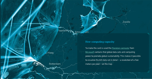
As you scroll through Crowds on the North Sea the map zooms and pans to highlight and explore the different types of shipping traffic active off the coast of the Netherlands. This includes large ferries (used for shipping passengers to and from the Netherlands) and the container ships constantly (sailing in and out of the huge Dutch commercial ports). The AIS tracks of dredging ships can also be seen as they work to keep the main shipping routes open for all other shipping traffic.

To help illustrate the huge amount of marine activity which takes place off the coast of Belgium the financial newspaper De Tijd created an animated map which visualizes 24 hours of marine traffic, using data from marinetraffic. On this animated map different colors are used to show four distinct types of marine vessel. In the story The North Sea is Teeming container ships are shown in yellow, the blue vessels are fishing boats, dredgers are shown in red and other types of ship are shown in gray.


Comments