The Viking Invasion
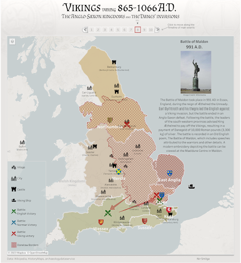
The Vikings: The Invasion of the Anglo-Saxon Kingdoms is an interactive map, created by Nir Smilga, which documents the history of the Viking incursions into the British Isles during the early-Middle Ages. These invasions eventually led to the Danelaw and Viking control of much of eastern and northern England.
The map covers a period of 201 years from the Arrival of the Great Heathen Army in 865 to the Battle of Stamford Bridge in 1066. The numbered timeline at the top of the interactive map allows you to progress through the history of the Viking invasion. This mapped history includes the Battle of York in 866, the Treaty of Wedmore (establishing Danelaw) in 886, the Battle of Maldon in 991, and the Battle of Stamford Bridge in 1066 (when King Harold defeated an invading Viking army).
The Vikings interactive map provides a fascinating potted history of the Vikings in Britain. If you are interested you can explore evidence of the lasting legacy of the Vikings and Danelaw in the continuing prevalence of Viking placenames in some areas of England.
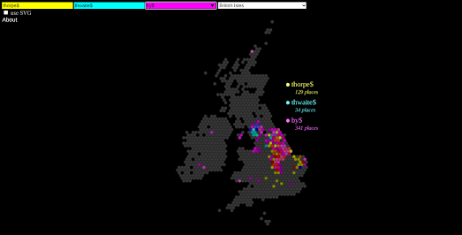
The Placename Patterns map allows you to visualize geographical patterns in the distribution of different types of placename. Using regular expressions it is possible to explore the distribution of different suffixes and prefixes in placenames in a number of different countries.
For example we can use the Placename Patterns to explore the geographical distribution of placenames ending in 'thwaite', 'thorpe' and 'by'. When we map these old Norse words we find their geographical distribution matches quite closely the Danelaw, the area of the UK which was once ruled by the Vikings. 'Thorpe' is an old Norse word for homestead. 'Thwaite' means wooded clearing and 'by' means farmstead or small village.


Comments