
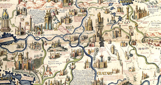
The only thing I love more than exploring historical vintage maps of the world is exploring annotated, interactive versions of ancient world maps. Now thanks to the Museo Galileo I can browse an annotated version of the world's greatest medieval map - the Fra Mauro World Map.
The Annotated Fra Mauro World Map is an interactive zoomable version of the famous 1450 Venetian map of the world. The map includes interactive annotations which allow you view translations of the map's nearly 3,000 cartouches, over 1,000 named cities, and the place-names of thousands of rivers, mountains, seas and islands.
If you enjoy exploring annotated vintage maps then you will probably also love Historia Cartarum Annotated Claudius Map. Historia Cartarum's annotated version of Matthew Paris' 13th Century map of Britain includes interactive annotations of every place-name and transcription on the Claudius Map. The result is a fantastic tool for studying one of the earliest geographical representations of Britain.

Fra Mauro's world map was created around 1450 by the Italian monk and cartographer Fra Mauro. His map is a circular planisphere with south orientated to the top of the map. Fra Mauro's map is one of the first European world maps to break from the tradition of Bible based cartography. In other words Fra Mauro's map favors geographical accuracy rather than religious beliefs and mythological stories.
Fra Mauro lived in the Republic of Venice. Venice had for centuries been an important center of trade between Europe and the Middle East and Africa. Before becoming a monk Fra Mauro had himself traveled as a merchant and a soldier. As a cartographer he was therefore able to draw from his own experience and from the many Arab traders and other world travelers passing through Venice. Instead of relying purely on traditional religious maps Fra Mauro could actually get first hand accounts from sailors, merchants and other travelers.
One area where Fra Mauro's break from the religious tradition of map making is apparent is in having south at the top. Placing south at the top was common in Arab maps of the time. In contrast, most European world maps had east at the top, mainly because east was the direction of the biblical Garden of Eden. Many European maps of the time also placed Jerusalem in the exact center of the map (and therefore the world). Fra Mauro's map also breaks with this tradition.
One result of Fra Mauro's more scientific approach to map making is that his map is the first European map to show Japan as an island and to show that it was possible to sail all the way around Africa.
Matthew Paris' Map of Britain is one of the first ever geographical maps of the British Isles. It was made by a 13th Century monk called (you guessed it) Matthew Paris. Paris' map was one of the first medieval maps to move away from a schematic plan (e.g. a strip map or route map) to instead attempt an accurate geographical representation (compare the Paris Map of Britain with Mathew Paris' own route itinerary maps outlining the journey from London to Palestine).
No comments:
Post a Comment