In March 2022 Russian troops invaded the Ukrainian village of Yahidne. During their month long occupation of the village the Russian army locked the villagers in a school basement. 360 people, including children and the elderly, where forced to live together in cramped and unsanitary conditions. There was so little space that people had to sleep standing up, people had to use buckets for toilets and there was very little food. During their imprisonment 11 of the villagers died.
It is impossible to imagine the conditions in which the 360 residents of Yahidne were forced to endure by the Russian army. However thanks to the power of phtoogrammetry you can explore a 3D model of the school basement where the villagers were imprisoned. Hidenori Watanave's
Satellite Images of Ukraine uses a 3D model to provide a virtual guided tour of the school basement.
The photogrammetry 3D scan of the basement was captured by Kyiv-based
@YaroPro4. This photogrammetry model was then added to a Cesium 3D globe by professor Hidenori Watanave of the University of Tokyo.
You can read more about the criminal actions of the Russian army in Yahidne and the awful conditions in which the villagers were kept on Time's article
A Ukrainian Village's Month in Captivity in a Basement.
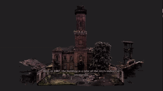
Australia's ABC News has published a number of 3D photogrammetry models to document the destruction caused by Russian missiles to culturally important Ukrainian buildings. The article
Culture in the Crosshairs includes three separate visualizations which reveal the devastating destruction being caused to important Ukrainian landmarks.
The 3D models of Kharkiv’s historic red brick fire station, the Irpin Bridge and Chernihiv's historic regional youth library were each created using LIDAR data captured on the ground in Ukraine. This data was then processed into 3D photogrammetry models. Models which ABC News are then able to use to create interactive fly-throughs documenting and highlighting the scale of destruction of each of these historic landmarks.
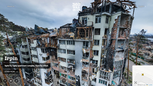
360war is also working to document the damage being caused to Ukraine by Russia's illegal war and to ensure that this senseless destruction is seen by people around the world.
360war is documenting the destruction of Ukrainian towns and villages, showing the aftermath of Russian air strikes and artillery fire on the infrastructure and buildings of Ukraine. Using panoramic 'Street View' imagery 360war allows you to explore in close detail some of the devastating destruction left behind by the Russian army.
An interactive map shows the location of all the available 'Street View' images (mainly concentrated in Kharkiv, Kyiv and Chernihiv). On this map aerial panoramic images are indicated using a drone shaped marker, while ground based panoramic images are shown with black dots. Many of the interactive panoramas include a 'learn more' link which provide more information on the location depicted and the damage caused by the invading Russian army.
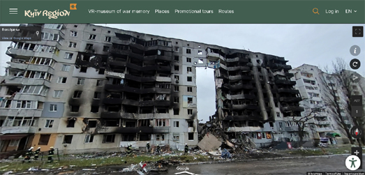
The Department of Tourism of the Kyiv Oblast State Administration is also determined to record and document the destruction being caused in their region. In order that no-one is ever able to forgot the crimes committed in the Kyiv region they have established a Virtual Museum of War Memory.
The main exhibit in the Virtual Museum of War Memory is a number of custom made Street View panoramas. These 360 degree panoramic images, taken at different locations in the Kyiv Oblast, allow you to take a virtual walk through some of the horrific destruction inflicted by the invading forces.
The Street View images for each of these virtual tours have also been added to Google Maps. This means that while exploring one of the museum's virtual tours you can click on the 'View on Google Maps' link to reveal the exact location on Google Maps. The 'i' information icon in the top right hand corner of the Street View image also reveals the name of the town where the panorama was taken.

These maps use data from images and videos captured in Ukraine to recreate incredible 3D models of some of the devastation caused by the Russian army. 3D photogrammetric models have been created of buildings and vehicles which have been destroyed during the war using drone captured imagery and photos taken on the ground. The result is a shocking interactive 3D map which allows you to view some of the devastating destruction in Ukraine from an almost first person perspective.


No comments:
Post a Comment