The World's Bioregions & Ecosystems Mapped
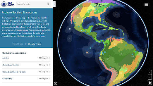
Bioregions 2023 is an interactive map which visualizes the Earth as 185 discrete bioregions. A bioregion is a geographical area defined not by political boundaries but by ecological systems. It is a geographical area that encompasses a unique set of interconnected ecosystems, landforms and watersheds in which a broad community of plants and animals are adapted to specific climatic conditions.
A bioregion is defined by natural boundaries such as mountains, rivers, and coastlines, rather than political or administrative borders. The Bioregion 2023 map recognizes 14 different types of bioregion, including deserts, mountain grasslands, mangroves and tundra.
You can click on the different bioregions on the Bioregions 2023 map to learn more about the unique ecosystems and wildlife that can be found within that system. Circle markers on the map list the unique species which live in a specific bioregion. If you select a specific bioregion on the map then the map sidebar will provide further details on the size of the region and how many ecoregions exist within that bioregion.

The Nature Map Explorer includes a number of map layers which allow you to explore global biodiversity and ecosystems. For example the Terrestrial Habitat Types layer shows where forests, wetlands, deserts and other types of habitat can be found around the globe. If you want to see how the world might look without humans you can view the Potential Natural Vegetation layer, which visualizes what vegetation cover we could expect without human impact.
The Species Richness layer shows where in the world there is an abundance of mammals, birds, reptiles and amphibians and where there is little remaining biodiversity in animal and plant life. You can also view the negative impact of humans on biodiversity using the Threatened Species Richness layer which visualizes where plant and animal species are under threat across the world.

You can also explore the many ecoregions of the world on the Ecoregions 2017 interactive map. This map provides a guide to 846 ecoregions around the globe. Using the map you can view the different ecoregions which can be found across the world and discover more about the distinct characteristics of each type of ecoregion.
Ecoregions are ecologically and geographically defined areas which have distinct natural characteristics, species and habitats. The ecoregions are colored on the map by the type of habitats that exist within them. If you hover over an area on the map you can view more details about the region's natural habitat and the biogeographic realm in which it exists.
The Ecoregions 2017 map also includes a number of other layers. These include a layer showing the global distribution of biomes, a layer showing the protected status of regions around the world and a 'realms' layer showing the Earth's eight biogeographic realms.


Comments