Russian Bombing in 3D
Satellite Images of Ukraine is an interactive map which allows you to explore 3D models of buildings destroyed by Russian bombing in the Ukrainian town of Borodyanka.
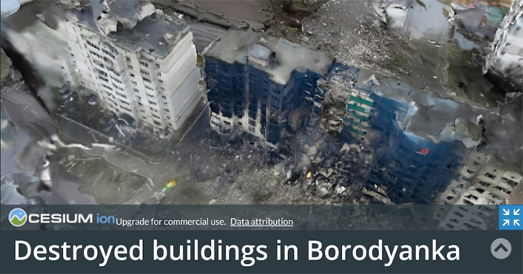
Last week Russian bombs destroyed the entire town center of Borodyanka, which is located about 37 miles north of Kyiv. The town had no Ukrainian military presence but Russia decided to decimate the town anyway, resulting in the murder of numerous civilians and the destruction of shops and residential buildings.
Satellite Images of Ukraine uses data from images captured in the town after it was struck by heavy bombing. 3D photogrammetric models were created of the town's destroyed buildings and vehicles using drone captured imagery and photos taken on the ground. The result is a shocking interactive 3D map which allows you to view the devastating destruction of Borodyanka from a first person perspective.
The use of interactive 3D models is a growing trend in data journalism. Here are links to some other examples of news organizations using photogrammetry to illustrate and explain major news events:


Comments