This is NOT a Map
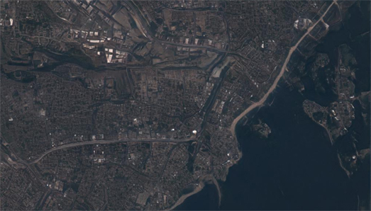
Argleton Harbour
This is Argleton Harbour, situated on the north-east coast of England.It is now a sleepy seaside town, relying on tourism and a small fishing industry to survive. It was once a busy port town, shipping coal to northern Europe, and unloading cargo (mainly from the Baltic countries). Like many northern towns Argleton Harbour hasn't yet recovered from the closure of England's coal mines.
Apart from the fall-out from the collapse of British industry Argleton Harbour has another problem. It does not exist. The satellite image above isn't a photo of a real location. It was in fact generated by artificial intelligence. This City Does Not Exist is a fun website which purports to show fake satellite images, generated by artificial intelligence. Just hit refresh on your browser and This City Does Not Exist will create another unique satellite image of a location that does not exist in the real world.
This City Does Not Exist links to a slideshow which suggests that the fake satellite images are created by a generative artificial intelligence model trained on satellite images from WorldView-2 and Sentinel 2.
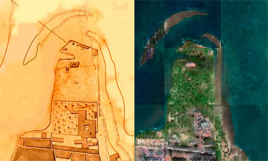
While This City Does Not Exist is fun to play with artificial intelligence powered satellite imagery can actually be very useful. In Use AI To Convert Ancient Maps Into Satellite-Like Images Michelle Hampson explores how machine learning algorithms can be trained to transform vintage maps of locations into 'fake' satellite images of the same locations.This could be used to show how land-use has changed over time, for example to visualize the urbanization of a location over a period of time.
Of course like any tool artificial intelligence models for creating deep-fake maps can be used for both good & evil. It doesn't take a great leap of imagination to believe that a rogue state might use fake satellite imagery to support military action. For example by creating fake satellite imagery to claim the presence of a chemical weapons factory in a country that they wish to invade.
Kim Eckart discusses the potential problems of deepfake satellite imagery in more detail in A growing problem of ‘deepfake geography’: How AI falsifies satellite images. In this article for the University of Washington Kim cites a new study published by the university which shows how deepfake satellite images can be created and discusses how we might develop tools for detecting fake satellite photos.
If you want to learn more about how artificial intelligence or a generative adversarial network (GAN) can be used to create fictional maps then you might like Topi Tjukanov's article Mapdreamer — AI cartography. Topi trained a GAN on 10,000 vintage maps. His article does a great job at explaining how a GAN works and how he built a GAN to create AI generated maps. It also contains lots of wonderful examples of the maps created by his AI GAN cartographer.


Comments