Liberating Ukraine
The Financial Times has taken a close look at the September counter-offensive which resulted in the reclamation of Russian held land in the north-east of Ukraine by the Ukrainian army. In The 90km journey that changed the course of the war the FT uses maps, photos and video to illustrate and explain how Ukraine managed to take back over 6000km of land and forced the Russian army to retreat.
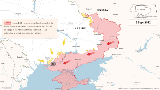
A Mapbox GL story-map is used by the FT to map the territory regained by Ukraine during the early weeks of September. As you scroll through this map you can see where and how the Russian army was forced to cede land as the month progressed. The map shows how before the counter-offensive began long range missiles were used to destroy Russian stores and arm depots and disrupt supply lines by destroying key bridges. At the same time Ukraine managed to fool Russia into believing that they were actually launching an attack in the south of the country. Russia responded by redeploying large numbers from the north-east to Kherson in the south.
As you continue scrolling through the map Ukraine's significant gains are shown on the map as the Ukraine held territory (shown in yellow on the map) grows and the Russian held territory (shown in red) retreats. In less than a week the Ukrainian army was able to recapture more than 6000km. It has been the most successful military manoeuvre of the entire war so far and hopefully marks a significant stage in Russia's eventual defeat.


Comments