Mapping Mariupol's Destruction

A Timeline of Mariupol's Destruction is an animated map which visualizes the damage caused to buildings by the Russian attacks on the Ukrainian city of Mariupol. The map shows damage caused by Russian bombing between March 5th and July 29th of this year.
The city of Mariupol was under siege from Russia from 25th February until 17th May 2022. In March the Red Cross declared the siege a humanitarian crisis. In May Ukarainian authorities reported that 90% of buildings in the city had been damaged or destroyed. Around 25,000 civilians are believed to have been killed in the Russian attacks on the city.The map was created by analysing satellite imagery of the city by PlanetScope. This analysis "found that 2,664 structures sustained significant damage in the city".
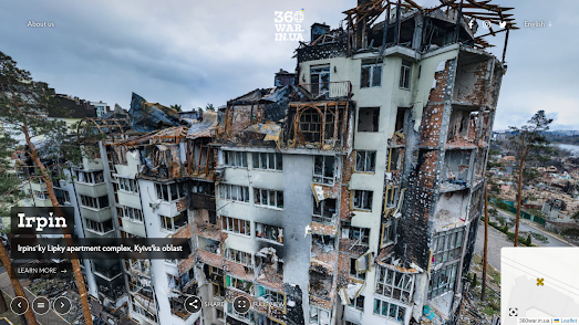
An interactive map shows the location of all the available 'Street View' images (Mariupol is still under Russian occupation so is not featured). On this map aerial panoramic images are indicated using a drone shaped marker, while ground based panoramic images are shown with black dots. Many of the interactive panoramas include a 'learn more' link which provide more information on the location depicted and the damage caused by the invading Russian army..


Comments