The 1911 Train Travel Map
Chronotrains was one of my favorite interactive maps of this summer. This interactive map shows you how far you can travel from any European rail station in less than five hours. Hover over any location on Chronotrains (within the highlighted area in Europe) and you can view an isochrone layer which shows you how far you can travel by train in hourly increments.
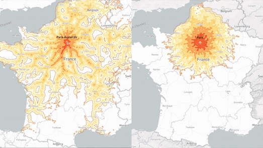
Now Benjamin, the developer of Chronotrains, has released Chronotrains 1911. This new interactive isochrone maps uses train travel times from 1911 to show you how far you could travel by train in five hours from any French station in the second decade of the 20th Century.
The animated GIF above shows Chronotrains and Chronotrains 1911 side-by-side, with the modern train times on the left and the 1911 train times on the right. In 2022 France has a lot of high speed rail lines which hadn't yet been constructed in 1911. However the map on the right shows that in 1911 France actually had a denser rail network with a lot more local stations than it does now.
The data for the 1911 map comes from Cambridge Universtiy's Communes project, which has digitised the French rail network from 1832 to 2015.


Comments